Report on Gaua (Vanuatu) — July 1991
Bulletin of the Global Volcanism Network, vol. 16, no. 7 (July 1991)
Managing Editor: Lindsay McClelland.
Gaua (Vanuatu) Increased fumarolic activity; vegetation killed
Please cite this report as:
Global Volcanism Program, 1991. Report on Gaua (Vanuatu) (McClelland, L., ed.). Bulletin of the Global Volcanism Network, 16:7. Smithsonian Institution. https://doi.org/10.5479/si.GVP.BGVN199107-257020
Gaua
Vanuatu
14.281°S, 167.514°E; summit elev. 729 m
All times are local (unless otherwise noted)
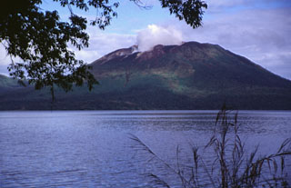
"An increase in fumarolic activity was noted by VANAIR pilots since April. On 13 July, a detailed aerial survey was conducted over the island during a VANAIR flight. Strong continuous degassing was observed, forming a dense white plume from the SE crater of Mt. Gharat cone. The NW slopes of the cone were largely denuded of vegetation, and the area of the caldera affected by the prevailing SE trade winds had burned vegetation. Due to this increasing activity, we plan to install a seismological station to monitor the volcano as soon as possible.
"Gaua is a composite volcano with a large (8 x 6 km) central caldera occupied by Lake Letas (428 m elev). Mt. Gharat (797 m elev) is an active basaltic cone located near the center of this caldera. Only solfataric activity was recorded from 1868 to 1962 (Mallick and Ash, 1975). Beginning in 1962, central crater explosions with frequent associated ash columns were reported nearly every year until 1977. Information on activity from 1977 to 1990 is scarce, but the volcano was probably quiet, with only minor steam emissions from the SE crater." [BVE reported strong gas emission in mid-1980, a black plume on 9 July 1981, and a brown plume with tephra on 18 April 1982.]
Reference. Mallick, D.I.J., and Ash, R.P., 1975, Geology of the southern Banks Islands: New Hebrides Geological Survey Regional Report, 33 p.
Geological Summary. The roughly 20-km-diameter Gaua Island, also known as Santa Maria, consists of a basaltic-to-andesitic stratovolcano with an 6 x 9 km summit caldera. Small vents near the caldera rim fed Pleistocene lava flows that reached the coast on several sides of the island; littoral cones were formed where these lava flows reached the ocean. Quiet collapse that formed the roughly 700-m-deep caldera was followed by extensive ash eruptions. The active Mount Garet (or Garat) cone in the SW part of the caldera has three pit craters across the summit area. Construction of Garet and other small cinder cones has left a crescent-shaped lake. The onset of eruptive activity from a vent high on the SE flank in 1962 ended a long period of dormancy.
Information Contacts: C. Robin and M. Monzier, ORSTOM, Nouméa, New Caledonia; M. Lardy and C. Douglas, ORSTOM, Vanuatu; C. Mortimer, Dept. of Geology, Mines, and Rural Water Supply, Vanuatu; J. Eissen, ORSTOM, France.