Report on Kuwae (Vanuatu) — July 1991
Bulletin of the Global Volcanism Network, vol. 16, no. 7 (July 1991)
Managing Editor: Lindsay McClelland.
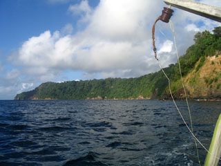
Kuwae (Vanuatu) Summit at 2-3 m depth; no visible fumarolic activity; sulfur odor
Please cite this report as:
Global Volcanism Program, 1991. Report on Kuwae (Vanuatu) (McClelland, L., ed.). Bulletin of the Global Volcanism Network, 16:7. Smithsonian Institution. https://doi.org/10.5479/si.GVP.BGVN199107-257070
Kuwae
Vanuatu
16.8304°S, 168.5227°E; summit elev. -2 m
All times are local (unless otherwise noted)
"Kuwae is a mainly submarine caldera (~10 x 5 km) that, according to 14C ages, Tongan folklore, and reconnaissance fieldwork (Garanger, 1972; Crawford, 1988), is probably very young (~1,500 A.D.). The caldera is located between Epi, Laika, and Tongoa islands in the central part of Vanuatu. During the ORSTOM-CALIS cruise in May 1991, detailed bathymetric and magnetic surveys of the collapse structure were made, and data are presently under analysis. August fieldwork was carried out on Tongoa and Laika Islands in order to study caldera eruption products, their composition, and their age. Several ignimbrite units, including non-welded ash and pumice flow deposits, and thick, complex sequences of poorly-welded to densely-welded tuffs, have been discovered. C14 ages will be determined for charcoal samples from these deposits.
"During the last century, the caldera's active Karua volcanic cone has emerged at least six times, in 1897, [1901], . . . 1948, [1949], 1959, and 1971. Each period of activity was accompanied by explosions. The ephemeral island reached a maximum size of 100 m tall and 1.5 km in diameter in 1949. On 6 August, during a visit by speedboat, the submerged summit area was 50-70 m large at 2-3 m depth. No fumarolic activity was observed despite a strong sulfur smell." [Turbulence and discolored sea water were observed in 1971-74 and 1977.]
References. Crawford, A.J., 1988, Circum-Pacific Council for Energy and Mineral Resources: Earth Science Series, v. 8.
Garanger, J., 1972, Publication de la Société Océanistes, no. 30.
Geological Summary. The largely submarine Kuwae caldera occupies the area between Epi and Tongoa islands. The 6 x 12 km caldera contains two basins that cut the NW end of Tongoa Island and the flank of the Tavani Ruru volcano on the SE peninsula of Epi Island. Native legends and radiocarbon dates from pyroclastic-flow deposits have been correlated with a 1452 CE ice-core peak thought to be associated with collapse of Kuwae caldera; however, others considered the deposits to be of smaller-scale eruptions and the ice-core peak to be associated with another unknown major South Pacific eruption. The submarine Karua cone in the east-central part of the caldera has formed several ephemeral islands since it was first observed in eruption during 1897.
Information Contacts: C. Robin and M. Monzier, ORSTOM, New Caledonia; M. Lardy and C. Douglas, ORSTOM,Vanuatu; C. Mortimer, Dept of Geology, Mines, and Rural Water Supply, Vanuatu; J. Eissen, ORSTOM, France.