Report on Whakaari/White Island (New Zealand) — October 1991

Bulletin of the Global Volcanism Network, vol. 16, no. 10 (October 1991)
Managing Editor: Lindsay McClelland.
Whakaari/White Island (New Zealand) Tephra from new vent
Please cite this report as:
Global Volcanism Program, 1991. Report on Whakaari/White Island (New Zealand) (McClelland, L., ed.). Bulletin of the Global Volcanism Network, 16:10. Smithsonian Institution. https://doi.org/10.5479/si.GVP.BGVN199110-241040
Whakaari/White Island
New Zealand
37.52°S, 177.18°E; summit elev. 294 m
All times are local (unless otherwise noted)
A new active crater formed in the S part of the 1978/91 Crater complex between visits by geologists on 9 and 23 October. The crater (named Wade; figure 14) had developed at the site of the former R.F. Crater, active January 1989-mid 1990. The onset of activity at the new crater was not documented, but may have been marked by E-type seismic events recorded on 18 October. The captain of the Island Princess reported that red ash had been falling for at least four days before 23 October.
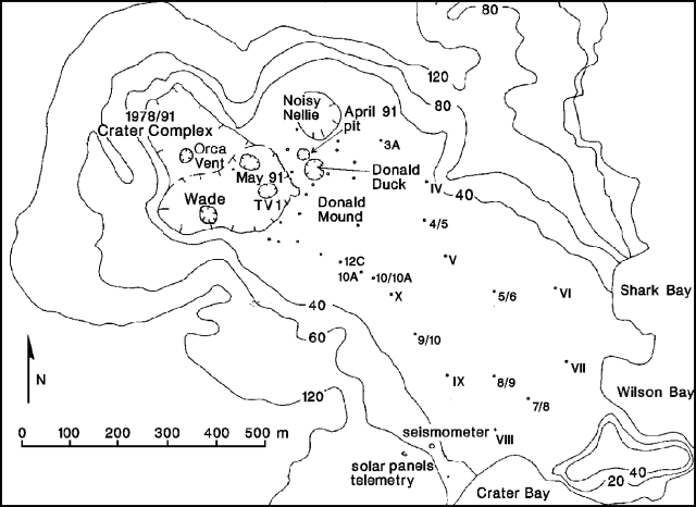 |
Figure 14. Map of White Island's Main Crater, showing the new (Wade) crater. The position of the 1978/91 Crater rim is as of 28 November 1990. Dots labeled with Roman numerals are levelling sites; only some are shown. Courtesy of B. Scott. |
As geologists approached the island on 23 October, activity was initially limited to moderate steam emission. At about 1120, an eruptive episode sent a red-brown steam/ash column to ~1 km above sea level. Long trains of low- to medium-frequency, low-amplitude earthquakes were recorded between 1115 and 1127, with a burst of stronger, higher frequency tremor at about 1118. During field studies between about 1230 and 1500, quiet emission of reddish ash-rich gas continued from the new circular crater, roughly 30-50 m in diameter and at least 30 m deep. Recently fallen red-brown ash was visible on all of the outer slopes of White Island. About 4 cm of ash had fallen at a site roughly 200 m SE of the new crater, thickening to 14 cm on the S rim of 1978/91 Crater. No significant juvenile component was evident in the ash.
A small amount of recently fallen ballistic tephra, including andesitic scoriae that are probably juvenile and accessory blocks, was found within 20 m of the SE rim of 1978/91 Crater. The orientation of ash thrown from the impact craters suggested an origin for the ballistic clasts in the direction of TV1 crater (roughly 100 m NE of the new crater), perhaps during the late-morning eruptive episode. TV1 may also have been the source of a layer of lithic gravel within a gray ash matrix, deposited to its E between layers of reddish ash. TV1 emitted only white steam until about 1315, when it began to erupt voluminous clouds of gray-brown ash. Ash emission was continuous for at least the next 30 minutes, and the color of the ash was noticeably different from that emerging from the simultaneously erupting new crater. TV1 had formed on 2 October 1990 and erupted again in February 1991, but had been relatively quiet since then. Little gas emerged from May 91 crater during the 23 October fieldwork, although it was the site of vigorous gas emission during the previous visit on 9 October.
Geological Summary. The uninhabited Whakaari/White Island is the 2 x 2.4 km emergent summit of a 16 x 18 km submarine volcano in the Bay of Plenty about 50 km offshore of North Island. The island consists of two overlapping andesitic-to-dacitic stratovolcanoes. The SE side of the crater is open at sea level, with the recent activity centered about 1 km from the shore close to the rear crater wall. Volckner Rocks, sea stacks that are remnants of a lava dome, lie 5 km NW. Descriptions of volcanism since 1826 have included intermittent moderate phreatic, phreatomagmatic, and Strombolian eruptions; activity there also forms a prominent part of Maori legends. The formation of many new vents during the 19th and 20th centuries caused rapid changes in crater floor topography. Collapse of the crater wall in 1914 produced a debris avalanche that buried buildings and workers at a sulfur-mining project. Explosive activity in December 2019 took place while tourists were present, resulting in many fatalities. The official government name Whakaari/White Island is a combination of the full Maori name of Te Puia o Whakaari ("The Dramatic Volcano") and White Island (referencing the constant steam plume) given by Captain James Cook in 1769.
Information Contacts: C. Wood, DSIR Geology & Geophysics, Rotorua.