Report on Akutan (United States) — March 1992
Bulletin of the Global Volcanism Network, vol. 17, no. 3 (March 1992)
Managing Editor: Lindsay McClelland.
Akutan (United States) Small steam-and-ash emissions
Please cite this report as:
Global Volcanism Program, 1992. Report on Akutan (United States) (McClelland, L., ed.). Bulletin of the Global Volcanism Network, 17:3. Smithsonian Institution. https://doi.org/10.5479/si.GVP.BGVN199203-311320
Akutan
United States
54.134°N, 165.986°W; summit elev. 1303 m
All times are local (unless otherwise noted)
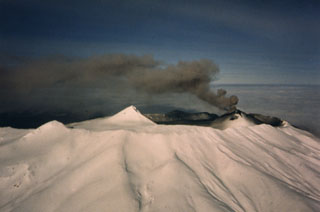
Small steam-and-ash emissions were observed periodically through mid-April, beginning at 1645 on 8 March, when a pilot flying near the volcano reported a small steam plume, possibly containing ash, that rose about 2 km above the summit. One hour later, only minor steaming was observed during a flight directly over the crater. A second flight at 1806 reported ash covering snow on the SW side of the crater. Minor steaming continued to be visible during flights at 1915 and 2006, rising to ~150 m. No activity was observed the following morning. Small steam and ash plumes, mostly <100 m high, were noted on 11-12 March.
Fishing vessels reported ashfall off Akutan Island on 22 March, following a pilot's report of a 4.3-km-high ash plume at 1637. No ashfall was reported 16 km NE, in Akutan village. A NOTAM was issued at 1224 on 24 March, prohibiting air traffic within 18 km of the volcano, up to 18 km altitude.
Activity was reported again on 7 April, when an Akutan village resident noted ash plumes rising 450-550 m above the volcano. Two days later, at 1000, a pilot reported an ash cloud at about 3-3.5 km altitude, drifting NW. A single lightning strike was recorded at the time of the eruption, by AVO's detection system.
Geological Summary. Akutan contains a 2-km-wide caldera with a large cinder cone in the NE part of the caldera that has been the source of frequent explosive eruptions and occasional lava effusion that covers the caldera floor. An older, largely buried caldera was formed during the late Pleistocene or early Holocene. Two volcanic centers are located on the NW flank. Lava Peak is of Pleistocene age, and a cinder cone lower on the flank produced a lava flow in 1852 that extended the shoreline of the island and forms Lava Point. The 60-365 m deep younger caldera was formed during a major explosive eruption about 1,600 years ago and contains at least three lakes. A lava flow in 1978 traveled through a narrow breach in the north caldera rim almost to the coast. Fumaroles occur at the base of the caldera cinder cone, and hot springs are located NE of the caldera at the head of Hot Springs Bay valley and along the shores of Hot Springs Bay.
Information Contacts: AVO; FAA.