Report on Whakaari/White Island (New Zealand) — April 1992
Bulletin of the Global Volcanism Network, vol. 17, no. 4 (April 1992)
Managing Editor: Lindsay McClelland.
Whakaari/White Island (New Zealand) New collapse crater; ash emission
Please cite this report as:
Global Volcanism Program, 1992. Report on Whakaari/White Island (New Zealand) (McClelland, L., ed.). Bulletin of the Global Volcanism Network, 17:4. Smithsonian Institution. https://doi.org/10.5479/si.GVP.BGVN199204-241040
Whakaari/White Island
New Zealand
37.52°S, 177.18°E; summit elev. 294 m
All times are local (unless otherwise noted)
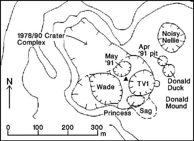
Continued eruptive activity in March and April was dominated by fine ash emission from Wade Crater (figure 17). Numerous E-type (eruption) earthquake sequences were recorded, but no new deposits of ballistic ejecta were evident. A new collapse crater (named Princess) developed in the SE part of the 1978/90 Crater complex in mid-April, and subsidence occurred over a substantial area nearby.
During 15 April fieldwork, Wade Crater emitted a gas column that included a little ash, while dense white steam emerged from nearby TV1 Crater ... . Sounds from Wade Crater appeared to have a deeper origin than previously, suggesting that the level of the magma column had dropped. Fumarolic activity NW of the 1978/90 Crater complex occurred with a strong, high-pitched roar. Fine, green-brown ash coated much of the Main Crater floor and walls. Stratigraphy of a pit dug roughly 200 m SE of Wade Crater included 57 mm of fine ash overlying a block/lapilli layer erupted in early March. The coarsest fraction of surface ash collected at the site was dominated by fresh crystals of plagioclase, orthopyroxene, and clinopyroxene, with minor amounts of vesiculated brown glass and a little altered lithic material. Fewer than 10 fresh impact craters were observed near the tephra pit; one contained a scoriaceous bomb, the others dense lava blocks. A detailed infrared survey was flown over White Island, but no data were available at press time.
The new crater was not present during 15 April fieldwork, but collapse had occurred by the time R. Fleming visited the island during the late morning of 17 April. The only significant seismicity during the 2-day interval was a 37-minute E-type event, similar to many others recorded during 1992, that began at 0002 on 17 April. Light ash emission was occurring from Wade Crater on 17 April, and ash fallout N of the island was too heavy to sail through on 18-19 April. Red ash was emerging from Wade Crater on 20 April, and an eruption column rose ~1,500 m on 21 April at 1445.
The new collapse crater was 60-70 m in diameter with nearly vertical walls, when first observed by geologists on 23 April. No coarse ejecta appeared to have been erupted during its formation. More than 4,000 m2 of the adjacent Main Crater floor had subsided and sagged toward the new crater. The head of the subsided area had a vertical scarp 1-1.5 m high, and its center had dropped an estimated 8-10 m. Given its shape, geologists suggested that the subsided area had previously been underlain by a SE-trending cavity.
Gray-brown ash collected near the subsided area on 23 April appeared to be mainly derived from crater-fill material involved in the formation of Princess Crater, with only a minor magmatic component. The sample's coarse fraction was dominated by white altered lithic material, although small amounts of black scoria and brown vesiculated glass were present. Many crystals had abraded surfaces and did not appear as fresh as those in the ash collected 15 April. Some fine pyrite clasts were also found in the sample.
Seismicity through 21 March was characterized by 2-5 A-type events/day. Significant volcanic tremor that was dominantly of medium frequency (3-5 Hz) resumed on 21 March. Individual tremor episodes lasting 2-9.5 hours continued through 31 March. A shallow ML 5 earthquake centered ~12 km NW of White island occurred on 26 March at 0527, followed by ~90 aftershocks in the next nine days. High-frequency A-type volcanic earthquakes began to increase on 29 March, averaging 7/day until a swarm of >150 events occurred on 3 April, with 58 more the next day; the largest reached ML 3.8. Seismicity remained elevated 5-12 April at >10 recorded events per day, then declined to more normal levels of 3-4/day. B-type events continued to be detected about every other day. No E-type earthquakes occurred from 18 March until one was recorded 2 April, but there were at least 20 from 6 to 16 April, sometimes accompanying the beginning or end of volcanic tremor episodes. Another E-type event was recorded on 21 April.
Geological Summary. The uninhabited Whakaari/White Island is the 2 x 2.4 km emergent summit of a 16 x 18 km submarine volcano in the Bay of Plenty about 50 km offshore of North Island. The island consists of two overlapping andesitic-to-dacitic stratovolcanoes. The SE side of the crater is open at sea level, with the recent activity centered about 1 km from the shore close to the rear crater wall. Volckner Rocks, sea stacks that are remnants of a lava dome, lie 5 km NW. Descriptions of volcanism since 1826 have included intermittent moderate phreatic, phreatomagmatic, and Strombolian eruptions; activity there also forms a prominent part of Maori legends. The formation of many new vents during the 19th and 20th centuries caused rapid changes in crater floor topography. Collapse of the crater wall in 1914 produced a debris avalanche that buried buildings and workers at a sulfur-mining project. Explosive activity in December 2019 took place while tourists were present, resulting in many fatalities. The official government name Whakaari/White Island is a combination of the full Maori name of Te Puia o Whakaari ("The Dramatic Volcano") and White Island (referencing the constant steam plume) given by Captain James Cook in 1769.
Information Contacts: B. Scott, DSIR Rotorua.


