Report on Unzendake (Japan) — May 1992

Bulletin of the Global Volcanism Network, vol. 17, no. 5 (May 1992)
Managing Editor: Lindsay McClelland.
Unzendake (Japan) Lava-dome growth and pyroclastic flows
Please cite this report as:
Global Volcanism Program, 1992. Report on Unzendake (Japan) (McClelland, L., ed.). Bulletin of the Global Volcanism Network, 17:5. Smithsonian Institution. https://doi.org/10.5479/si.GVP.BGVN199205-282100
Unzendake
Japan
32.761°N, 130.299°E; summit elev. 1483 m
All times are local (unless otherwise noted)
Lava-dome growth continued through mid-June, and pyroclastic flows were frequently generated by partial collapse of the dome complex. The new dome (7) which first appeared on 24 March (correction to 17:3-4), continued to grow, reaching 150 m length by the end of May. Lava extrusion formed "banana peel" and sometimes "petal" structures (petal with two lobes). Swelling of the cryptodome raised its summit to 1,390 m elevation, 30 m higher than the pre-eruption summit. Lava blocks on the surface of the cryptodome were reddish in color and small (< 10 m across, commonly a few m across), suggesting to geologists that they had broken into pieces during intrusion. Earthquakes, probably occurring within the dome complex, frequently triggered collapse of the cryptodome, causing it to develop a conical shape with a relatively smooth surface.
Collapses occurred at both sides of the growing lobes on dome 7, as well as at the dome front. One rockfall, measured by the GSJ with a theodolite, was estimated to have a volume of 1.2 x 10⁵ m3. Pyroclastic flows generated from rockfalls traveled primarily down the dome complex's SE flank towards Mt. Iwatoko and into the Akamatsu valley, extensively burying its gentle slope (figure 42). Ash clouds accompanying the flows rose to about 1,000 m, with a maximum height of 1,400 m on 19 May. The pyroclastic-flow-deposit distribution was little changed from previous months. During mid-May to mid-June, 2-3 flows extended > 2 km/day, a flow 2.5 km long occurred every two days, and no flows reached > 3 km from the dome complex. Longer flows had a tendency to erode the steeper, upstream area, then deposit in the middle and downstream areas. The eroded upstream channels were subsequently filled by less-energetic flows. The longer flows tended to follow topographic lows quite closely, and as the saddle in the Akamatsu Valley was filled (~ 2.2 km SE from the front of dome 7), the height of the S cliff decreased from 30 to 10 m by early June. A deposition rate of ~ 35 cm/day was calculated for the mid-May to mid-June period.
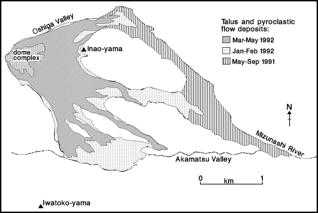 |
Figure 42. Map showing distribution of 1991-92 pyroclastic flow deposits at Unzen, mid-June 1992. 1991 pyroclastic surge deposits are not shown. Courtesy of Setsuya Nakada. |
The magma-supply rate, based on mapping by the Geographical Survey Institute, was estimated to be roughly 2 x 10⁵ m3/day for late February-late April, the lowest value since June 1991 (prior reported rates ranged from 2.5 to 3.5 x 10⁵ m3/day). The low magma-supply rate reflects the low level of activity in April, when the lava domes grew very little, large pyroclastic flows were rare, and seismicity was at low levels. Estimates of magma supply in May-early June suggest that the rate had returned to ~ 3 x 10⁵ m3/day. Geologists believe that the supply rate has probably fluctuated considerably since February. The volume of the dome complex was estimated to be 44 x 106 m3 on 25 April (similar to that of late February); combined pyroclastic flow and avalanche deposits, 50 x 106 m3 (dense rock equivalent); indicating a total erupted volume of ~ 94 x 106 m3.
Continued geomagnetic measurements by Kyoto Univ scientists show that the degree of demagnetization around the dome complex had decreased from mid-March. Demagnetization was strongest when lava first appeared in May 1991, and continued steadily until February 1992. Electronic distance measurements collected by the GSJ also showed the strongest shortening (between the summit and a point ~ 1.5 km away) in May 1991, and steady shortening through recent months, implying continuous swelling of the summit region.
Small earthquakes continued to occur beneath and within the dome complex, with 50-150/day in May-early June. A total of 3,235 earthquakes was recorded in May, similar to April. The daily number of seismically detected pyroclastic flows ranged from 5 to 17, with a total of 337 events, similar to previous months.
The evacuated area E of the volcano, in Shimabara and Fukae town, was reduced somewhat in June, decreasing the number of evacuees from 7,600 in May [to] about 6,750 by 11 June.
Geological Summary. The massive Unzendake volcanic complex comprises much of the Shimabara Peninsula east of the city of Nagasaki. An E-W graben, 30-40 km long, extends across the peninsula. Three large stratovolcanoes with complex structures, Kinugasa on the north, Fugen-dake at the east-center, and Kusenbu on the south, form topographic highs on the broad peninsula. Fugendake and Mayuyama volcanoes in the east-central portion of the andesitic-to-dacitic volcanic complex have been active during the Holocene. The Mayuyama lava dome complex, located along the eastern coast west of Shimabara City, formed about 4000 years ago and was the source of a devastating 1792 CE debris avalanche and tsunami. Historical eruptive activity has been restricted to the summit and flanks of Fugendake. The latest activity during 1990-95 formed a lava dome at the summit, accompanied by pyroclastic flows that caused fatalities and damaged populated areas near Shimabara City.
Information Contacts: S. Nakada, Kyushu Univ; JMA.