Report on Colima (Mexico) — June 1992

Bulletin of the Global Volcanism Network, vol. 17, no. 6 (June 1992)
Managing Editor: Lindsay McClelland.
Colima (Mexico) Rockfalls and thermal activity; large lahar deposit described
Please cite this report as:
Global Volcanism Program, 1992. Report on Colima (Mexico) (McClelland, L., ed.). Bulletin of the Global Volcanism Network, 17:6. Smithsonian Institution. https://doi.org/10.5479/si.GVP.BGVN199206-341040
Colima
Mexico
19.514°N, 103.62°W; summit elev. 3850 m
All times are local (unless otherwise noted)
The following . . . covers activity between 10 April and 30 June 1992, and describes the 25 June 1991 lahar deposits.
Seismicity and rockfall activity. After a brief seismic crisis 4-10 March, activity at Colima remained near background levels. Starting 10 April, seismicity became more frequent. Nine B-type earthquakes were detected by the Red Sismológica de Colima (RESCO) and up to 60 events were recorded 10-20 May at the SW-flank Yerbabuena station (figure 17). Subsequent seismic activity remained near background, with only four B-type earthquakes recorded by RESCO 20-31 May, and three between 1 and 20 June. Seismic activity increased slightly 21-30 June, when 22 B-type earthquakes were recorded and the number of associated seismically detected rockfalls reached 55. Other rockfalls were also noted, probably associated with small diurnal changes in the volcano's hydrothermally altered summit region, which might be related to changes in rock temperature and surface water content. Extraordinary out-of-season precipitation in January, related to the El Niño/Southern Oscillation event of 1991-92, exceeded 700% of the monthly mean of the past 30 years and must have saturated the volcano's upper porous regions.
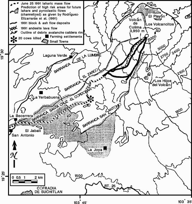 |
Figure 17. Sketch map of the summit area and SW flank of Colima, showing major canyons and recent volcanic deposits. Modified from Rodríguez-Elizarrarás, and others, 1991. |
Current thermal activity. Fumarolic activity has been steady, with an impressive white plume that can rise several hundred meters above the summit before dissipating. This represents the systematic release of meteoric water accumulated in the upper part of the volcano, not an increase in the magmatic component of the fumarolic activity. Further avalanching of the most precarious hydrothermally altered regions of the summit area is expected during the rainy season, which has just started.
25 June 1991 lahar deposit. Block-and-ash flows emplaced about 1 x 10⁶ m3 of loose pyroclastic debris in the upper Barranca El Cordobán during collapse of the crater dome and rim on 16-17 April 1991, just before the 1991 lava flow began to move down the SW flank (figure 17) (Rodríguez-Elizarrarás and others, 1991). Despite heavy rains in May-September 1991, geologists from the CICT reported that most of the pyroclastic deposits had been washed away without producing sizeable mudflows (Rodríguez-Elizarrarás, and others, 1991). Nevertheless, on 28 March 1992, S. de la Cruz-Reyna and CICT geologists observed a significant laharic mass-flow deposit near El Jabalí, which was studied 5-7 June by J.-C. Komorowski and CICT geologists. A more thorough field and laboratory investigation of this deposit is in progress.
The lahar reached the settlements of La Becerrera and San Antonio, ~12 km SW of the summit (figure 17). Unequivocal non-reworked lahar material was seen at 1,280 m elevation, ~500 m above the confluence of the barrancas El Zarco and El Cordobán. The total thickness was 2 m with a channel width of 30 m. Deposits from this lahar have been identified up to ~1,900 m above sea level, at the bottom of a 20-30-m vertical lava wall in the barranca El Cordobán. The barranca's slope flattens drastically after the lava wall, so deposition probably began below this point. The most distant block-and-ash flow deposits in this barranca reached down to 2,100 m elevation. Upstream, the barranca was significantly eroded by water and debris from a maximum elevation of 2,600 m. Although there is no clear evidence of lahar deposits at San Antonio and La Becerrera, one person reported that the water crossing on the San Antonio-Laguna Verde road was obstructed for two days by lahar material, until machines cleared the debris. Such occurrences are frequent in the rainy season, because several large barrancas draining the upper slopes join there to form a channel 30 m wide.
We estimate the total lahar path at 9.9 km. Based on several measurements at different sites, the lahar deposit averages 25 m wide and 2 m thick. Maximum width was 38 m and maximum thickness 2.9 m at 1,640 m elevation (star on figure 17). Volume was estimated at approximately 0.5 x 10⁶ m3, or about 50% of the material estimated to have been emplaced by the 16-17 April 1991 pyroclastic activity. Field evidence and testimony (see below) unequivocally show that all of the lahar deposit was emplaced during one event. April 1992 field studies of barrancas at higher altitude revealed tremendous erosion since April 1991, leaving ravines incised deeply (to 15 m) into the pre-1991 pyroclastic deposits. A significant volume of loose 1991 debris remains on the mountain, ready to be incorporated into lahars during the rainy season.
Preliminary field investigations showed that the lahar deposit is characterized by a very flat surface, with suspended lava blocks to 1-2 m in maximum dimension protruding through the surface, and abundant pumiceous clasts from eroded 1913 deposits. The deposit is massive, non-stratified, non-graded, poorly sorted, and matrix supported. Its typical massive lowermost zone (0.6 m thick), locally well-sorted, has a concentration of blocks (to 0.5 m size) and wood fragments at the base, a prominent clast-supported medial zone (0.7 m thick) with imbricated sub-rounded boulders (to 0.3 m), and an uppermost massive unit (0.8 m) with a tendency toward reverse grading of lithic cobbles, supported in a sandy matrix. The deposit is typically semi-indurated. Inter-unit contacts are sharply defined in several places, most likely reflecting shear between rheologically different portions of the mass flow. Given the large suspended blocks, the very flat surface, the constant thickness over 9 km of travel distance, the presence of marginal levees, and overturned logs that came to rest vertically, the mass flow clearly had a significant yield strength. However, it must have been relatively swift, as it was able to flow around topographic barriers in the channel, and in some places to leave an elevated deposit on the outside wall when it rounded a sharp curve.
Few people witnessed the lahar. The best testimony came from a farmer (Ramón Aguirre Valencia) who went to Barranca El Cordobán on 26 June 1991 to check his cattle. At 1,600 m altitude, the barranca was filled by a gravel- and boulder-rich deposit with a flat surface. Rocks on the surface were coated with a thin layer of light-colored fine ash. Of the 20 cows killed by the lahar, several could be seen, with horns, heads, and feet protruding from the deposit. Numerous tree trunks several meters long and as much as 30 cm in diameter were also on the lahar's surface. Heavy rains had occurred the previous day, and the lahar apparently began to form after about 2 hours of heavy precipitation, accompanied by loud thunder. The nearest meteorological station (Cofradía de Suchitlán), about 12 km from the lahar's most likely source area, recorded 50 mm of rain on 25 June. By 3 July, a ravine had developed in the new lahar that was as deep (4.6 m) but not as wide as the present channel, which now spans 10.6 m of the 38-m-wide deposit. Five kilometers downstream, the lahar overran and destroyed a 2-m-high stone wall at El Jabalí and clogged the existing channel, but 2 km farther downslope, residents of La Becerrera noticed nothing unusual. Larger sediment flows reported at La Becerrera in January may have been related to breaching of a small earthen dam.
Warnings of future lahar flows and the hazards within Barranca El Cordobán were reiterated to authorities in 1992, as abundant loose material remains from the 1991 eruption and recently exposed 1913 pyroclastic units. The El Jabalí basin is filled with old mass-flow deposits that have traveled down several steep, deeply incised barrancas. On 12 June, CICT organized a meeting that included civil protection authorities to discuss these hazards.
Reference. Rodríguez-Elizarrarás, C., Siebe, C., Komorowski, J.-C., Espindola, J.M., and Saucedo, R., 1991, Field observations of pristine block-and-ash flow deposits emplaced April 16-17, 1991 at Volcán de Colima, México: Journal of Volcanology and Geothermal Research, v. 48, no. 3/4, p. 399-412.
Geological Summary. The Colima complex is the most prominent volcanic center of the western Mexican Volcanic Belt. It consists of two southward-younging volcanoes, Nevado de Colima (the high point of the complex) on the north and the historically active Volcán de Colima at the south. A group of late-Pleistocene cinder cones is located on the floor of the Colima graben west and east of the complex. Volcán de Colima (also known as Volcán Fuego) is a youthful stratovolcano constructed within a 5-km-wide scarp, breached to the south, that has been the source of large debris avalanches. Major slope failures have occurred repeatedly from both the Nevado and Colima cones, producing thick debris-avalanche deposits on three sides of the complex. Frequent recorded eruptions date back to the 16th century. Occasional major explosive eruptions have destroyed the summit (most recently in 1913) and left a deep, steep-sided crater that was slowly refilled and then overtopped by lava dome growth.
Information Contacts: Carlos Navarro, Abel Cortés, I. Galindo, José J. Hernández, and Ricardo Saucedo, CICT, Universidad de Colima; Jean-Christophe Komorowski and Claus Siebe, Instituto de Geofísica, UNAM.