Report on Piton de la Fournaise (France) — September 1992

Bulletin of the Global Volcanism Network, vol. 17, no. 9 (September 1992)
Managing Editor: Lindsay McClelland.
Piton de la Fournaise (France) Summit fissure eruption follows 7 months of seismicity
Please cite this report as:
Global Volcanism Program, 1992. Report on Piton de la Fournaise (France) (McClelland, L., ed.). Bulletin of the Global Volcanism Network, 17:9. Smithsonian Institution. https://doi.org/10.5479/si.GVP.BGVN199209-233020
Piton de la Fournaise
France
21.244°S, 55.708°E; summit elev. 2632 m
All times are local (unless otherwise noted)
An eruption began on 27 August after 7 months of increased seismicity below the summit crater and the E flank of the summit cone. Up to 19 earthquakes/day were recorded during the days before the eruption (figure 31). Focal depths were from about sea level to 1.5 km altitude . . . . (figure 32).
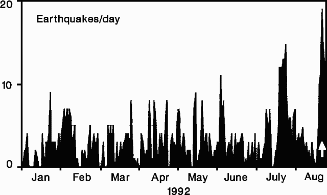 |
Figure 31. Daily number of earthquakes at Piton de la Fournaise, January-August 1992. A white arrow marks the start of the eruption. Courtesy of OVPDLF. |
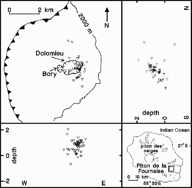 |
Figure 32. Epicenters of seismic events at Piton de la Fournaise, 2-26 August 1992, with N-S and E-W hypocentral cross-sections. A sawtooth pattern marks the rim of Enclos Fouque caldera. The epicenter map's location is indicated by the small rectangle on the inset map. Courtesy of OVPDLF. |
Immediate eruption precursors - seismicity. A shock at 1054 on 27 August marked the onset of the pre-eruption seismic crisis. About 30 events of up to M 1.3 were detected between then and the swarm's strongest shock (M 2.2) at 1105. More than 100 seismic events of M >1.3 followed until 1150, when generalized tremor indicated the start of the eruption. Hypocenters were beneath the E part of the Dolomieu Crater between the summit and sea level. Geologists interpreted the seismic pattern as resulting from a shallow magma pocket feeding an intrusion moving up towards the Dolomieu area.
Immediate eruption precursors - deformation. Rapid changes in vertical ground deformation began less than an hour before the eruption at electronic tiltmeters between the Dolomieu crater rim and sites 8 and 9 km away. The maximum radial component of 1,300 µrad was recorded on the SE side of the crater (station DOL, figure 33). Less deformation (<=20 µrad, tangential) was detected 1.5-2 km away, and at 8 and 9 km the deformation was 0.8 µrad (radial) and 7 µrad (tangential), respectively. At stations around the crater rim, tilt values (3, 10, and 12 µrad/minute at BOR, SOU, and DOL, respectively) and directions from 1111 to 1124 indicated inflation centers and possible intrusion below the SW part of the crater (figure 33). Tilt values increased between 1125 and 1133 to 5, 10, and 30 µrad/minute, respectively, with NW tilts at BOR and SOU, and a SE tilt at DOL. This pattern suggested a general inflation of Dolomieu, but inflation centers could not be identified. The period 1134-1139 was similar, with the highest tilt at DOL. During 1140-1145, tilt vectors rotated at SOU and BOR while the radial component at DOL inverted. This period is interpreted by geologists as a deflation episode. Deformation stopped after 1145 at the BOR and SOU stations, but continued until 1155 at DOL.
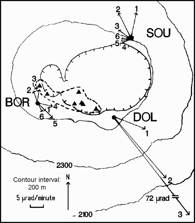 |
Figure 33. Map of the summit area of Piton de la Fournaise, showing tilt vectors at BOR, SOU, and DOL stations for six time-periods on 27 August; the first five periods begin at 1111, 1125, 1134, 1140, and 1146. Tilt vectors could not be calculated at DOL after 1134. Inflation centers calculated from tilt vectors are indicated by triangles enclosed by the dashed line. Hachures mark the rims of Bory and Dolomieu craters. Courtesy of OVPDLF. |
Eruptive activity. The eruption began at 1150 from a fissure within Dolomieu crater that produced lava fountains ~40 m high and a small basaltic lava flow. The fissure propagated rapidly southward, crossed the SW rim, and produced a small flank flow (flow 1; figure 34). Four additional vents opened at 1211, 1214, 1216, and 1221, producing lava flows 2-5. The first four flows halted within 3 hours, but high lava fountains (>40 m) at vent 5, SE of Dolomieu crater, quickly built a cone, named Zoé. The high velocity of flow 5 and strong degassing were noted 3 hours after the start of the eruption. Geologists from the OVPDLF reported 40-m lava fountains and intense SO2-rich degassing on 28 August. Flow velocity at the foot of the cone was estimated at 4 m/s, suggesting a mean outflow rate of ~20 m3/s. Geologists estimated that Zoé crater produced 5 x 10⁶ m3 of lava, covering ~1 x 10⁶ m2. Flows 1-4 included an additional 5 x 10⁵ m3 of aphyric basalt. Tremor decreased rapidly and had reached low levels by mid-September. Tremor ceased on 23 September after ~20 hours of strong seismic activity related to the collapse of the main crater and surface feeding structures. Outflow was very weak during the eruption's last days, and the total volume of lava remained at 5.5 x 10⁶ m3.
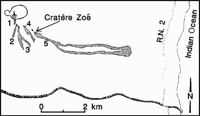 |
Figure 34. Sketch map of the southern part of Enclos Fouque caldera on Piton de la Fournaise, showing Zoe Crater and the area covered by the five successive lava flows on 27 August 1992. The area shown is indicated by the small rectangle on the inset map. Courtesy of OVPDLF. |
Geological Summary. Piton de la Fournaise is a massive basaltic shield volcano on the French island of Réunion in the western Indian Ocean. Much of its more than 530,000-year history overlapped with eruptions of the deeply dissected Piton des Neiges shield volcano to the NW. Three scarps formed at about 250,000, 65,000, and less than 5,000 years ago by progressive eastward slumping, leaving caldera-sized embayments open to the E and SE. Numerous pyroclastic cones are present on the floor of the scarps and their outer flanks. Most recorded eruptions have originated from the summit and flanks of Dolomieu, a 400-m-high lava shield that has grown within the youngest scarp, which is about 9 km wide and about 13 km from the western wall to the ocean on the E side. More than 150 eruptions, most of which have produced fluid basaltic lava flows, have occurred since the 17th century. Only six eruptions, in 1708, 1774, 1776, 1800, 1977, and 1986, have originated from fissures outside the scarps.
Information Contacts: J. Toutain, P. Kowalski, P. Labazuy, P. Taochy, A. Tessier, and A. Pham, OVPDLF; J-L. Cheminée, P. Blum, J. Zlotnicki, A. Hirn, and J. Lepine, IPGP.