Report on Manam (Papua New Guinea) — October 1992

Bulletin of the Global Volcanism Network, vol. 17, no. 10 (October 1992)
Managing Editor: Lindsay McClelland.
Manam (Papua New Guinea) Strong explosions feed 10-km column; lava and pyroclastic flows; 18 buildings destroyed
Please cite this report as:
Global Volcanism Program, 1992. Report on Manam (Papua New Guinea) (McClelland, L., ed.). Bulletin of the Global Volcanism Network, 17:10. Smithsonian Institution. https://doi.org/10.5479/si.GVP.BGVN199210-251020
Manam
Papua New Guinea
4.08°S, 145.037°E; summit elev. 1807 m
All times are local (unless otherwise noted)
"Manam continued to erupt during October, with a paroxysmal phase of activity from Southern Crater at the beginning of the month and a series of strong effusive phases from Main Crater in the middle of the month. "Activity had increased at Southern Crater at the end of September (29th and 30th). Continuous bright-red glow and projections of incandescent lava fragments were accompanied by moderate-to-dense emissions of white (occasionally blue) vapour, frequent rumbling, and occasional explosion noises. This culminated in a paroxysmal eruption on 1 October, which produced an ash column rising ~10 km above the crater. Pyroclastic flows descended SW and SE Valleys, but were contained in them and did not cause any property damage (figure 4). The flows in SW Valley advanced ~4 km from the crater while those in SE Valley traveled ~3.5 km. Moderate-heavy scoria fall on the W side of the island reportedly damaged some food gardens. A new lava flow in SW Valley advanced ~1.6 km from the crater. After the eruption, activity at Southern Crater declined, with weak-to-moderate emissions of white and occasional blue vapour throughout the month.
"Main Crater was more active in October with weak-to-moderate emissions of white vapour, accompanied occasionally by forceful projections of dark-grey ash rising a few hundred meters above the crater. On the night of the 9th, projections of brightly incandescent lava fragments were observed. At about 0400 on the 10th, very bright continuous glow was seen above the summit, quickly followed by lava extrusion into NE Valley. The lava was channeled into four low-lying gullies and reached the sea in two places.
"There was no night glow for two days after the eruption, and only small-to-moderate amounts of white vapour were emitted. An aerial inspection showed a deep funnel-shaped vent in Main Crater. Main Crater activity subsequently intensified and emissions changed to thick white vapour and frequent expulsions of dense grey ash clouds rising several hundred meters above the summit crater. "On 14 October, a brief period of more intense activity took place. Commencing at 0445, the activity consisted of frequent rumbling and explosion noises, red incandescent lava-fragment projections, and forceful emissions of dense grey ash clouds at a rate of ~3/minute. The visible activity was accompanied by a rise in seismicity. Most of the eruptive activity stopped at about 1530. An aerial inspection of the summit showed that projections of incandescent material were continuing, but the vent was choked with debris.
"About 0600 on the 15th, Main Crater activity intensified again. The rate of explosions of lava fragments and ash was ~5/minute. At 0830, the red incandescent projections became continuous, reaching ~100 m above the crater. Two small pyroclastic flows seen around this time traveled only a few hundred meters downslope from the vent. At 1015 lava was extruded into NE Valley. The lava flow overwhelmed 3 houses in a village near the S edge of the valley and entered the sea along a wider flow-front than on 10 October. Lava effusion stopped at about 1245. The eruptive column reached ~6 km above the crater during this period.
"Between 16 and 18 October, the summit was covered in atmospheric clouds so no observations were possible. No noises were heard, but the seismograph showed that seismic activity was high.
"When the summit cleared early on 19 October, a weak glow was seen from Main Crater, which brightened as time progressed. No incandescent projections were observed. Intermittent, low rumbling noises were heard from 0450 onward. There appeared to be a slow build-up of an eruption column during the morning. The summit was obscured after 0650. Inhabitants on the N side of the island reported a pyroclastic flow in NE Valley at about 0920. This advanced ~3 km from the summit, stopping 200 m short of a village. Lava extrusion followed, with a large volume of lava (although probably smaller than on 10 and 15 October) channeled into the S half of the valley, reaching within 60 m of the coast. Effusive activity stopped in the early afternoon.
"Following this eruption, the level of activity declined and remained low until the 25th, when explosions began to intensify again. There was an increase in seismicity and in visible activity, with emissions of dense dark-grey ash clouds, rumbling noises, and bright-red glow at night.
"A total of 14 houses and four cocoa fermentaries, all constructed from bush materials, were destroyed by the lava flows in October. The emplacement of pyroclastic flows and lava flows in the main valleys at Manam has clearly demonstrated the high hazard-potential of these parts of the volcano. Recommendations have been made for the evacuation of settlements near SW and NE Valleys. It is not anticipated that the entire population of Manam will need to be evacuated.
"Measurements from the water-tube tiltmeter . . . showed 1.5 µrad of inflation up to 8 October, and 4 µrad of deflation following the paroxysmal eruption on the 10th. Inflation was recorded from the 23rd until the end of the month.
"Figure 5 shows seismic signal amplitudes for September and October. The eruptions on 16 September and 1 and 10 October were preceded by gradual increases in seismicity, over periods of 4-10 days. The 15 October eruption took place during a period of high seismicity, whereas the eruption of 19 October occurred during a decline in seismic activity."
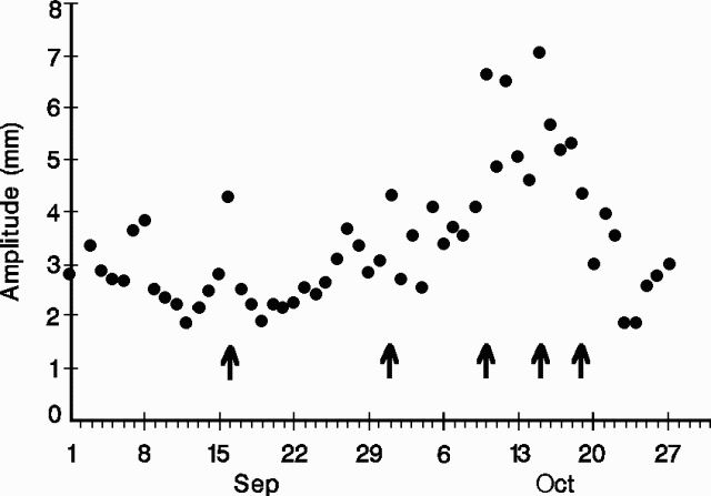 |
Figure 5. Seismic-signal amplitudes recorded at Manam, September-October 1992. The amplitudes are daily means based on the mean amplitudes of the five largest events each hour. Arrows mark the five strongest eruptive episodes. Courtesy of RVO. |
Geological Summary. The 10-km-wide island of Manam, lying 13 km off the northern coast of mainland Papua New Guinea, is one of the country's most active volcanoes. Four large radial valleys extend from the unvegetated summit of the conical basaltic-andesitic stratovolcano to its lower flanks. These valleys channel lava flows and pyroclastic avalanches that have sometimes reached the coast. Five small satellitic centers are located near the island's shoreline on the northern, southern, and western sides. Two summit craters are present; both are active, although most observed eruptions have originated from the southern crater, concentrating eruptive products during much of the past century into the SE valley. Frequent eruptions, typically of mild-to-moderate scale, have been recorded since 1616. Occasional larger eruptions have produced pyroclastic flows and lava flows that reached flat-lying coastal areas and entered the sea, sometimes impacting populated areas.
Information Contacts: I. Itikarai, R. Stewart, and C. McKee, RVO.