The Darwin Volcanic Ash Advisory Centre (VAAC) reported that an ash plume from Manam was identified in a satellite image at 1020 on 16 May drifting SE. The plume had dissipated by 1220.
Source: Darwin Volcanic Ash Advisory Centre (VAAC)
Low thermal activity during January-June 2023
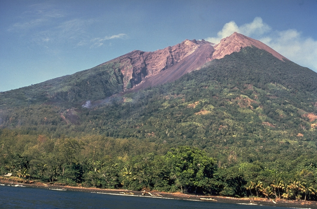
Manam is a 10-km-wide island that consists of two active summit craters: the Main summit crater and the South summit crater and is located 13 km off the northern coast of mainland Papua New Guinea. Frequent mild-to-moderate eruptions have been recorded since 1616. The current eruption period began during June 2014 and has more recently consisted of ash plumes and thermal activity (BGVN 48:07). This report covers activity during January through June 2023 primarily using various satellite data.
Weak and intermittent sulfur dioxide plumes were detected using the TROPOMI instrument on the Sentinel-5P satellite, some of which exceeded at least two Dobson Units (DU) and drifted in different directions (figure 96). Few low-power thermal anomalies were recorded by the MIROVA (Middle InfraRed Observation of Volcanic Activity) system; two anomalies were captured during January, one during late March, one during early April, one during late May, and one during early June (figure 97). On clear weather days, thermal activity was captured in infrared satellite images in both the Main and South summit craters (figure 98).
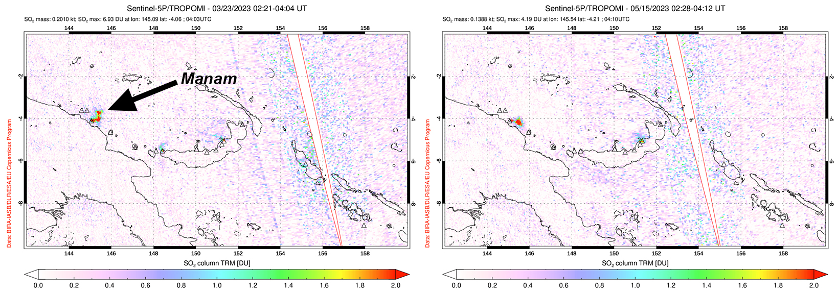 |
Figure 96. Distinct sulfur dioxide plumes were visible rising above Manam based on data from the TROPOMI instrument on the Sentinel-5P satellite on 23 March 2023 (left) and 15 May 2023 (right). Plumes drifted NE and SE, respectively. Courtesy of the NASA Global Sulfur Dioxide Monitoring Page. |
 |
Figure 97. Few thermal low-power thermal anomalies were detected at Manam during January through June 2023, as shown in this MIROVA graph (Log Radiative Power). Two anomalies were captured during January, one during late March, one during early April, one during late May, and one during early June. Courtesy of MIROVA. |
 |
Figure 98. Infrared (bands B12, B11, B4) satellite images show a consistent thermal anomaly (bright yellow-orange) in both the Main (the northern crater) and South summit craters on 14 January 2023 (top left), 3 February 2023 (top right), 24 April 2023 (bottom left), and 28 June 2023 (bottom right). The two craters are just under 400 m apart. Gas-and-steam emissions occasionally accompanied the thermal activity. Courtesy of Copernicus Browser. |
Information Contacts: MIROVA (Middle InfraRed Observation of Volcanic Activity), a collaborative project between the Universities of Turin and Florence (Italy) supported by the Centre for Volcanic Risk of the Italian Civil Protection Department (URL: http://www.mirovaweb.it/); NASA Global Sulfur Dioxide Monitoring Page, Atmospheric Chemistry and Dynamics Laboratory, NASA Goddard Space Flight Center (NASA/GSFC), 8800 Greenbelt Road, Goddard, Maryland, USA (URL: https://so2.gsfc.nasa.gov/); Copernicus Browser, Copernicus Data Space Ecosystem, European Space Agency (URL: https://dataspace.copernicus.eu/browser/).
2025: January
| March
| May
2024: May
| June
| September
| October
| November
| December
2022: February
| March
| April
| May
| June
| July
| October
| November
| December
2021: January
| May
| June
| October
| November
| December
2020: March
| July
| August
| September
| December
2019: February
| March
| May
| June
| July
| September
| October
| November
2018: June
| August
| September
| October
| December
2017: March
| April
| May
| August
2016: March
| July
2015: January
| February
| March
| April
| May
| June
| July
| August
| September
| October
2014: September
| December
2013: January
| February
| March
| April
| May
| June
| July
| August
| September
| November
| December
2012: May
| June
| July
| October
| November
| December
2011: January
| August
| October
| November
2010: August
| September
| October
| November
| December
2009: May
| June
| October
| December
2008: April
| May
| July
| August
| September
| October
| November
| December
2007: January
| February
| March
| April
| May
| June
| August
| September
| October
| December
2006: January
| February
| March
| April
| May
| July
| August
| November
| December
2005: January
| February
| March
| April
| May
| June
| July
| August
| September
| October
2004: April
| September
| October
| November
| December
2003: May
2002: February
| May
| October
2001: June
| September
The Darwin Volcanic Ash Advisory Centre (VAAC) reported that an ash plume from Manam was identified in a satellite image at 1020 on 16 May drifting SE. The plume had dissipated by 1220.
Source: Darwin Volcanic Ash Advisory Centre (VAAC)
The Darwin Volcanic Ash Advisory Centre (VAAC) reported that an ash plume from Manam was identified in a satellite image at 1230 on 15 March drifting NNW. The plume had dissipated by 1510.
Source: Darwin Volcanic Ash Advisory Centre (VAAC)
The Darwin Volcanic Ash Advisory Centre (VAAC) reported that continuous ash plumes from Manam were identified in satellite images at 0640 and 1050 on 14 January. The plumes rose to an altitude of 2.1 km (7,000 ft) a.s.l. and drifted WSW.
Source: Darwin Volcanic Ash Advisory Centre (VAAC)
The Darwin Volcanic Ash Advisory Centre (VAAC) reported that continuous ash plumes from Manam were identified in satellite images at 1850 and 2000 on 7 January. The plumes rose to an altitude of 2.4 km (8,000 ft) a.s.l. and drifted E and SE.
Source: Darwin Volcanic Ash Advisory Centre (VAAC)
The Darwin Volcanic Ash Advisory Centre (VAAC) reported that an ash plume from Manam was identified in satellite images at 1710 and 2020 on 24 December drifting NW and NNW at an altitude of 2.7 km (9,000 ft) a.s.l.
Source: Darwin Volcanic Ash Advisory Centre (VAAC)
The Darwin Volcanic Ash Advisory Centre (VAAC) reported that ash emissions from Manam were identified in satellite images at 1330 and 2220 on 4 December drifting W and WNW at an altitude of 2.1 km (7,000 ft) a.s.l.
Source: Darwin Volcanic Ash Advisory Centre (VAAC)
The Darwin Volcanic Ash Advisory Centre (VAAC) reported that ash emissions from Manam were identified in satellite images during 29 November-1 December rising 2.4-3 km (8,000-10,000 ft) a.s.l. and drifting NW and W. Weather clouds occasionally obscured or partially obscured views.
Source: Darwin Volcanic Ash Advisory Centre (VAAC)
The Darwin Volcanic Ash Advisory Centre (VAAC) reported that continuous ash emissions Manam were identified in satellite images during 20-25 November rising to 2.4 km (8,000 ft) a.s.l. and drifting NW, W, and SW. Weather clouds occasionally obscured or partially obscured views.
Source: Darwin Volcanic Ash Advisory Centre (VAAC)
The Darwin VAAC reported that at 0900 on 15 November an ash plume from Manam was identified in satellite images rising to 2.1 km (7,000 ft) a.s.l. and drifting NW. The plume had dissipated by 1100 on 16 November. A period of continuous ash emissions was identified in satellite images during 0430-1730 on 17 November. Weather clouds and darkness obscured views through the night but by 0920 on 18 November the ash plumes were no longer visible and had dissipated.
Source: Darwin Volcanic Ash Advisory Centre (VAAC)
The Darwin VAAC reported that continuous ash emissions from Manam were observed in satellite images acquired by HIMAWARI-9 on 30 October, rising to approximately 2.1 km (7,000 ft) above sea level, dispersing E and SE, and dissipating by 1930 UTC on the same day. The Aviation Color Code remained at Orange.
Source: Darwin Volcanic Ash Advisory Centre (VAAC)
The Darwin VAAC reported that ash plumes from Manam were identified in webcam and satellite images during 26-28 October rising to 2.4 km (8,000 ft) a.s.l. and drifting E, SW, and W. The plumes were sometimes continuous, though weather clouds often obscured views.
Source: Darwin Volcanic Ash Advisory Centre (VAAC)
The Darwin VAAC reported that ash plumes from Manam were identified in satellite images during 10-13 October rising to 2.4 km (8,000 ft) a.s.l. and drifting NW, WNW, and W. The plumes were mostly continuous, though weather clouds sometimes obscured views.
Source: Darwin Volcanic Ash Advisory Centre (VAAC)
The Darwin VAAC reported that ash plumes from Manam were identified in satellite and webcam images, and reported by the Rabaul Volcano Observatory, rising to 2.7 km (9,000 ft) a.s.l., or about 1 km above the summit, and drifting NW at 1000 on 3 October. The ash emissions were continuous during 3-5 October, though weather clouds sometimes obscured views. The ash had dissipated by 2140 on 5 October. At 1250 on 7 October a continuous ash plume was identified in satellite images rising to 2.4 km (8,000 ft) a.s.l. and drifting NW.
Source: Darwin Volcanic Ash Advisory Centre (VAAC)
The Darwin VAAC reported that during 0000-0600 on 29 September ash plumes from Manam were identified in satellite images rising 2.4 km (8,000 ft) a.s.l. and drifting NW. At 0230 on 1 October an ash plume rose 4 km (13,000 ft) a.s.l. and drifted S.
Source: Darwin Volcanic Ash Advisory Centre (VAAC)
The Darwin VAAC reported that at 2040 on 11 September an ash plume from Manam was identified in a satellite image rising 5.2 km (17,000 ft) a.s.l. and drifting NNW. The plume had dissipated by 0210 on 12 September.
Source: Darwin Volcanic Ash Advisory Centre (VAAC)
The Darwin VAAC reported that continuous ash plumes from Manam were identified in satellite images at 0740, 1330, and 1530 on 17 June rising 2.1 km (7,000 ft) a.s.l. and drifting WNW.
Source: Darwin Volcanic Ash Advisory Centre (VAAC)
The Darwin VAAC reported that on 12 May an ash plume from Manam rose to 4.6 km (15,000 ft) a.s.l. and drifted E based on satellite images and weather models. The plume had dissipated by 0030 on 13 May.
Source: Darwin Volcanic Ash Advisory Centre (VAAC)
The Darwin VAAC reported that on 26 December an ash plume from Manam rose to 3 km (10,000 ft) a.s.l. and drifted S and SSE based on satellite images.
Source: Darwin Volcanic Ash Advisory Centre (VAAC)
The Darwin VAAC reported that on 20 November ash plumes from Manam rose to 1.8 km (6,000 ft) a.s.l. and drifted NW based on satellite images.
Source: Darwin Volcanic Ash Advisory Centre (VAAC)
The Darwin VAAC reported that on 14 November an ash plume from Manam rose to 2.1 km (7,000 ft) a.s.l. and drifted W based on RVO webcam images.
Source: Darwin Volcanic Ash Advisory Centre (VAAC)
The Darwin VAAC reported that on 7 November an ash plume from Manam rose to 2.1 km (7,000 ft) a.s.l. and drifted NE based on satellite images and weather models. The plume had dissipated within four hours.
Source: Darwin Volcanic Ash Advisory Centre (VAAC)
The Darwin VAAC reported that on 29 October an ash plume from Manam rose to 1.5 km (5,000 ft) a.s.l. and drifted NW based on satellite images. The plume had dissipated within three hours.
Source: Darwin Volcanic Ash Advisory Centre (VAAC)
The Darwin VAAC reported that on 14 July ash plumes from Manam rose to 2.1 km (7,000 ft) a.s.l. and drifted NW based on satellite and RVO webcam images.
Source: Darwin Volcanic Ash Advisory Centre (VAAC)
The eruption at Manam was ongoing. The Darwin VAAC reported that during 1-3 and 5 June ash plumes rose to 2.4-3 km (8,000-10,000 ft) a.s.l. and drifted NW, W, and SW, based on satellite and webcam images and information from RVO.
Source: Darwin Volcanic Ash Advisory Centre (VAAC)
The Darwin VAAC reported daily ash plumes at Manam during 25-29 May. At 0720 on 25 May an ash plume rose to 2.4 km (8,000 ft) a.s.l. and drifted W, and dissipated within 30 minutes. Ash plumes rose to 2.1 km (7,000 ft) a.s.l. and drifted NW during 25-26 May. An eruptive event, observed at 0657 on 27 May by RVO and webcam images, produced an ash plume that rose to 2.4 km a.s.l. based on webcam views; weather clouds prevented satellite views of the emissions. On 28 May an ash plume rose to 2.1 km a.s.l. and drifted NE. A thermal anomaly over the volcano was visible following the emission. On 29 May diffuse ash plumes rose to 2.1-2.4 km a.s.l. and drifted in multiple directions.
Source: Darwin Volcanic Ash Advisory Centre (VAAC)
The Darwin VAAC reported that during 17-19 May ash plumes from Manam rose to 2.4 km (8,000 ft) a.s.l. and drifted NW and W based on satellite images and weather models.
Source: Darwin Volcanic Ash Advisory Centre (VAAC)
The Darwin VAAC reported that during 13-16 May ash plumes from Manam rose to 2.4-3.7 km (8,000-12,000 ft) a.s.l. and drifted NE, SW, and W based on satellite images and weather models.
Source: Darwin Volcanic Ash Advisory Centre (VAAC)
The Darwin VAAC reported that during 3-4 May ash plumes from Manam rose to 2.1 km (7,000 ft) a.s.l. and drifted SE and NW based on information from RVO, satellite images, and weather models. On 6 May ash plumes rose to 1.8 km (6,000 ft) a.s.l. and drifted NW and WNW.
Source: Darwin Volcanic Ash Advisory Centre (VAAC)
The Darwin VAAC reported that on 1 May ash plumes from Manam rose to 2.7 km (9,000 ft) a.s.l. and drifted SE and ESE based on information from RVO, satellite images, and weather models. During 2-3 May low-level ash emissions rose to 2.1 km (7,000 ft) a.s.l. and drifted ESE.
Source: Darwin Volcanic Ash Advisory Centre (VAAC)
The Darwin VAAC reported that on 18 April ash plumes from Manam rose to 13.7 km (45,000 ft) a.s.l. and drifted N based on information from RVO, satellite images, and weather models. Ash had dissipated by 1540. At 2000 an ash plume was visible in a satellite image through a break in weather cloud cover drifted NE at an altitude of 4.9 km (16,000 ft) a.s.l. Ash had dissipated by 0830 on 19 April.
Source: Darwin Volcanic Ash Advisory Centre (VAAC)
The Darwin VAAC reported that during 15-17 March ash plumes from Manam rose to 3 km (10,000 ft) a.s.l. and drifted SW, W, and NW.
Source: Darwin Volcanic Ash Advisory Centre (VAAC)
The Darwin VAAC reported that on 14 March an ash plume from Manam rose to 2.4 km (8,000 ft) a.s.l. and drifted W. Ash plumes later that day and on 15 March rose to 3 km (10,000 ft) a.s.l. and drifted SW and W.
Source: Darwin Volcanic Ash Advisory Centre (VAAC)
RVO reported that a small pyroclastic flow descending Manam’s flank was visually observed and recorded in webcam images at 0911 on 8 March. Minor ash emissions drifting NW were occasionally visible throughout the day. RSAM values sharply increased at 1900 coincident with escalating activity. An intense Strombolian phase at Southern Crater was observed during 1910-2030, characterized by loud roaring and rumbling heard on the mainland (22 km SW), bright summit incandescence, and ash emissions. The Alert Level was raised to Stage 3. The Darwin VAAC estimated that by 1950 the ash plume had risen as high as 15.2 km (50,000 ft) a.s.l. and drifted W. The plume had detached from the summit by 2050 and dissipated by 0050 on 9 March. Following the more intense eruptive phase, activity at Southern Crater was quiet and only white vapor emissions were visible. Observatory staff conducted a field visit the next day and noted no reports of roof collapses nor casualties in areas to the NW; vegetation including food crops were covered with ash.
Source: Rabaul Volcano Observatory (RVO)
The Darwin VAAC reported that on 14 February ash plumes from Manam rose to 2.4 (8,000 ft) a.s.l. and drifted SE.
Source: Darwin Volcanic Ash Advisory Centre (VAAC)
The Darwin VAAC reported that a large thermal anomaly over Manam was identified in satellite images during 21-22 December. A discrete ash plume rose to 3.4 km (11,000 ft) a.s.l. and drifted SE on 21 December. Ash plumes may have risen to 10.7 km (35,000 ft) a.s.l. during 0137-0300 on 22 December, though weather clouds and heavy rain obscured satellite views; the plumes were unconfirmed by ground observers. At 1200 on 22 December an ash plume rose to 4.9 km (16,000 ft) a.s.l., drifted E, and dissipated within four hours.
Source: Darwin Volcanic Ash Advisory Centre (VAAC)
The Darwin VAAC reported that a thermal anomaly over Manam was identified in satellite images on 15 December, prior to an ash emission that rose to 6.1 km (20,000 ft) a.s.l. and drifted SW. An ash plume rising to the same altitude was visible in satellite images on 16 December but had dissipated by mid-morning. Later that day diffuse ash plumes rising to 2.4 km (8,000 ft) a.s.l. were visible in satellite images and reported by ground observers, according to RVO. An eruptive event was recorded by the seismic network at 0600 on 17 December; ground observations indicated that an ash plume likely rose to 3 km (10,000 ft) a.s.l. and drifted SE. At 0840 ash emissions identified in satellite images and by observers rose to 3 km, drifted SE, and dissipated within about five hours. At 0220 on 18 December an ash plume rose to 3 km, drifted SE, and again dissipated within about five hours; a thermal anomaly over the summit was visible in the satellite data. At 1600 on 21 December an ash plume rose to 1.5 km (5,000 ft) a.s.l., drifted NE, and dissipated within about three hours. The thermal anomaly persisted.
Source: Darwin Volcanic Ash Advisory Centre (VAAC)
The Darwin VAAC reported that on 3 and 8 November ash plumes from Manam rose to 1.8 km (6,000 ft) a.s.l. and drifted NW and W based on satellite data and weather models.
Source: Darwin Volcanic Ash Advisory Centre (VAAC)
According to the Darwin VAAC, ground-based observers at Manam observed on going, low-level eruptive activity on 21 October. Ash emissions rose as high as 2.4 km (8,000 ft) a.s.l. and drifted W. Within a few hours, ash had dissipated and activity was no longer visible.
Source: Darwin Volcanic Ash Advisory Centre (VAAC)
RVO reported that sporadic small ash emissions from Manam’s Southern Crater were observed starting at the end of September. Nighttime incandescence began on 8 October and incandescent material was occasionally ejected from the crater. The activity was characterized as moderately Strombolian with incandescent material rolling down SW Valley, visibly appearing as short lava flows. The Darwin VAAC noted that on 18 October an ash plume rose to 2.4 km (8,000 ft) a.s.l. and drifted NW. A thermal anomaly was visible in satellite images.
RVO stated that at around 0800 on 20 October a large explosion at Southern Crater produced ash plumes that rose at least 1 km above the summit and drifted N and NW. According to the Darwin VAAC ash plumes rose as high as 15.2 km (50,000 ft) a.s.l. between 0840-0950, expanded radially, and then drifted E. Lower-level plumes rose 4.6-5.5 km (15,000-18,000 ft) a.s.l. and drifted NW. Later that day a collapse of newly erupted material, as well deposits from the previous few weeks, produced a debris flow that originated at the head of the valley and descended the SW Valley.
Sources: Rabaul Volcano Observatory (RVO); Darwin Volcanic Ash Advisory Centre (VAAC)
The Darwin VAAC reported that on 23 June ash plumes from Manam rose to 2.1-2.4 km (7,000-8,000 ft) a.s.l. and drifted W, WNW, and NW.
Source: Darwin Volcanic Ash Advisory Centre (VAAC)
The Darwin VAAC reported that during 20-21 May ash plumes from Manam rose to 2.1 km (7,000 ft) a.s.l. and drifted NW.
Source: Darwin Volcanic Ash Advisory Centre (VAAC)
The Darwin VAAC reported that on 23 January ash plumes from Manam rose to 4.9 km (16,000 ft) a.s.l. and drifted SE and N.
Source: Darwin Volcanic Ash Advisory Centre (VAAC)
Based on analyses of satellite imagery and model data, the Darwin VAAC reported that on 6 December an ash emission from Manam rose to an altitude of 2.4 km (8,000 ft) a.s.l. and drifted SW.
Source: Darwin Volcanic Ash Advisory Centre (VAAC)
The Darwin VAAC reported that on 11 September ash plumes from Manam rose 2.4 km (8,000 ft) a.s.l. and drifted W, based on satellite data and weather models.
Source: Darwin Volcanic Ash Advisory Centre (VAAC)
The Darwin VAAC reported that on 20 August an ash plume from Manam rose 2.1 km (7,000 ft) a.s.l. and drifted W and WSW, based on satellite data and a ground-based observer. On 31 August an ash plume rose to 4.6 km (15,000 ft) a.s.l. and drifted W.
Source: Darwin Volcanic Ash Advisory Centre (VAAC)
The Darwin VAAC reported that on 16 August ash plumes from Manam rose 2.1-4.3 km (7,000-14,000 ft) a.s.l. and drifted W and NW.
Source: Darwin Volcanic Ash Advisory Centre (VAAC)
The Darwin VAAC reported that on 6 August an ash plume from Manam rose to 3 km (10,000 ft) a.s.l. and drifted SW. The next day ash plumes rose to 2.1 km (7,000 ft) a.s.l. and drifted W.
Source: Darwin Volcanic Ash Advisory Centre (VAAC)
RVO reported that seismicity at Manam began increasing on 16 July and fluctuated between low and moderate levels through the 29th. A slow steady increase of RSAM values was recorded on 30 July, and RVO stated that an observer had reported that incandescent material had been ejected from the summit. The Darwin VAAC noted that a sustained and intense thermal anomaly was visible in satellite images that same day. During 31 July-1 August ash plumes drifted NW at an altitude of 4.3 (14,000 ft) a.s.l. and a lava flow at the summit was visible.
Sources: Rabaul Volcano Observatory (RVO); Darwin Volcanic Ash Advisory Centre (VAAC)
The Darwin VAAC reported that during 20-21 March ash plumes from Manam rose to an altitude of 3 km (10,000 ft) a.s.l. and drifted E, based on satellite data and weather models.
Source: Darwin Volcanic Ash Advisory Centre (VAAC)
RVO reported that at 1330 on 2 November a single large explosion at Manam generated a dense dark ash plume that rose 1 km above the summit and drifted NW. A shock wave was felt at the Bogia Government station (about 40 km SE) about 1 minute later. RSAM values on 6 November fluctuated between 250 and 360 units but began to increase around 1430 and triggered alerts around 1445. Values continued to increase and reached 400-500 units, heralding an eruption which began during 1600-1630. A gray ash plume rose 1 km and drifted NW. Incandescent material ejecting from the vent was visible at the start of the eruption and became more visible as the evening grew darker. The eruption peaked in intensity around 1930, then declined and ceased during 2100-2200.
Source: Rabaul Volcano Observatory (RVO)
RVO reported that white emissions rose from Manam during 1-7 October and variable crater incandescence from Main Crater was visible at night. Seismicity was at low to moderate levels with RSAM values fluctuating around 300 units. The Darwin VAAC reported that during 3-4 October diffuse ash plumes rose to an altitude of 3 km (10,000 ft) a.s.l. and drifted N and NW, based on satellite data and weather models. A thermal anomaly was also visible.
Source: Rabaul Volcano Observatory (RVO)
The Darwin VAAC reported that on 29 September diffuse ash plumes from Manam rose to altitudes of 2.4-2.7 km (8,000-9,000 ft) a.s.l. and drifted W, based on satellite data and weather models. A sulfur dioxide signature in the plume was also detected. On 30 September RVO reported increased seismicity; the VAAC noted ongoing emissions and a persistent thermal anomaly.
Source: Darwin Volcanic Ash Advisory Centre (VAAC)
The Darwin VAAC reported that on 21 July an ash plume from Manam rose to an altitude of 4.3 km (14,000 ft) a.s.l. and drifted SW and W, based on satellite data and weather models.
Source: Darwin Volcanic Ash Advisory Centre (VAAC)
The Darwin VAAC reported that on 12 July an ash plume from Manam rose to an altitude of 3.7 km (12,000 ft) a.s.l. and drifted N, based on satellite data and weather models.
Source: Darwin Volcanic Ash Advisory Centre (VAAC)
According to the United Nations in Papua New Guinea an estimated 1,410 people from seven villages remained affected from the 27 June eruption of Manam; as many as 455 homes and many gardens had been destroyed. The Darwin VAAC reported that on 6 July ash plumes rose to 5.5-6.1 km (18,000-20,000 ft) a.s.l. and drifted W and NW.
Sources: United Nations in Papua New Guinea; Darwin Volcanic Ash Advisory Centre (VAAC)
RVO reported that RSAM values at Manam began increasing on 27 June and then spiked from 540 to over 1,400 within a short period of time (~30 min). According to news articles, residents reported hearing thundering noises around 0100 on 28 June. An eruption plume was visible in satellite images around 0620 drifting SW, around the time residents reported the start of the eruption. The Darwin VAAC issued a notice stating that by 0910 the ash plume had risen to 15.2 km (50,000 ft) a.s.l. and was drifting SW. Pyroclastic flows descended the W and NE flanks. About 3,775 people evacuated their homes. Additional ash plumes rose to 4.6 km (15,000 ft) a.s.l. and drifted W, and by 1700 the higher-altitude plume had detached from the volcano and continued to drift SW. A thermal anomaly persisted on 29 June, and the next day an ash plume rose to 2.4 km (8,000 ft) a.s.l. and drifted W.
Air Niugini stopped all aircraft overnighting in Madang due to the eruption. On 30 June they resumed operations at Hoskins airport, after rerouting all flights out of nearby airports during 29-30 June.
Sources: Rabaul Volcano Observatory (RVO); Darwin Volcanic Ash Advisory Centre (VAAC); Simon Carn; ABC News - Australian Broadcasting Corporation; ReliefWeb; Reuters; Post-Courier; EMTV Online
The Darwin VAAC reported that on 18 June ash plumes from Manam rose to altitudes of 3-3.7 km (14,000 ft) a.s.l. and drifted E and NE, based on satellite data and weather models. A thermal anomaly was also visible.
Source: Darwin Volcanic Ash Advisory Centre (VAAC)
The Darwin VAAC reported that during 7-8 June ash plumes from Manam rose to an altitude of 4.3 km (14,000 ft) a.s.l. and drifted SW, based on satellite data and weather models.
Source: Darwin Volcanic Ash Advisory Centre (VAAC)
The Darwin VAAC reported that on 10 May an ash plume from Manam rose to an altitude of 5.5 km (18,000 ft) a.s.l. and drifted NE, based on satellite data and weather models. A sulfur dioxide plume and a thermal anomaly were also identified. The next day diffuse plumes drifted NE and E at an altitude of 2.4 (8,000 ft) a.s.l.
Source: Darwin Volcanic Ash Advisory Centre (VAAC)
The Darwin VAAC reported that on 29 March ash plumes from Manam rose to altitudes of 2.4-3 km (8,000-10,000 ft) a.s.l. and drifted E, NE, and N based on satellite data and weather models. A thermal anomaly was also visible.
Source: Darwin Volcanic Ash Advisory Centre (VAAC)
The Darwin VAAC reported that during 19-22 March ash plumes from Manam rose to an altitude of 4.6 km (15,000 ft) a.s.l. and drifted E and SE based on satellite data and ground-based observations.
Source: Darwin Volcanic Ash Advisory Centre (VAAC)
The Darwin VAAC reported that during 5-6 March ash plumes from Manam rose to an altitude of 3 km (10,000 ft) a.s.l. and drifted E based on satellite data and ground-based observations. A significant thermal anomaly was also visible in satellite images, and seismicity was elevated.
Source: Darwin Volcanic Ash Advisory Centre (VAAC)
The Darwin VAAC reported that on 1 and 5 March ash plumes from Manam were identified in satellite images rising to an altitude of 3 km (10,000 ft) a.s.l. and drifting SE, ESE, and E.
Source: Darwin Volcanic Ash Advisory Centre (VAAC)
Based on analyses of satellite imagery and model data, the Darwin VAAC reported that on 15 February an ash plume from Manam rose to an altitude of 4.9 km (16,000 ft) a.s.l. and drifted E.
Source: Darwin Volcanic Ash Advisory Centre (VAAC)
The Darwin VAAC reported that on 6 December ash plumes from Manam were identified in satellite images rising to an altitude of 5.2 km (17,000 ft) a.s.l. and drifting SE. RVO noted that at 1215 on 8 December seismicity increased and indicated an eruption had begun, according to a news article. The eruption was characterized by forceful ash emissions, explosions that ejected lava fragments above the crater, and rumbling and roaring noises. Around 1300, based on pilot observations, information from RVO, and satellite images, large ash plumes rose as high as 15.2 km (50,000 ft) a.s.l and drifted E. Island reports noted that ejections of material ceased around 1900; audible noises ended around 1930. Satellite data indicated that ash from the high-altitude plume had begun to dissipate by 2020, and that on-going ash emissions rose to 8.2 km (27,000 ft) a.s.l. Island residents described heavy ashfall and that the sun was blocked by airborne ash, based on second-hand social media posts. News reports indicated that residents in Bokure and Kolang (NE and ENE flanks, respectively) had evacuated. Seismicity had declined by the end of the day. Dark ash plumes continued to be visible the next day, rising as high as 7.6 km (25,000 ft) a.s.l. and drifting E, though were less frequent.
Sources: Darwin Volcanic Ash Advisory Centre (VAAC); ReliefWeb; Loop; Loop
RVO reported that during 2-12 October brown, gray-brown, and dark gray ash emissions rose as high as 1 km above Manam’s Southern Crater rim and drifted NW. Main Crater produced occasional white emissions, though on 2 October plumes were gray-brown and contained ash. Bluish vapor was noted during 3-4 October.
Source: Rabaul Volcano Observatory (RVO)
RVO reported that on 1 October field observations after an eruption at Manam confirmed lava flows in the NE valley. There were two lava flow lobes, both stopping before inhabited areas; the smaller lobe flowed on the N side of the valley towards Koland Village and the larger flowed on the S side towards Boakure Village. Effects from ash and scoria fallout on the NW and NW sides of the island were minor. Based on analyses of satellite imagery and wind model data, the Darwin VAAC reported that on 3 October an ash plume rose 2.1 km (7,000 ft) a.s.l. and drifted NW. A thermal anomaly was also visible.
Sources: Rabaul Volcano Observatory (RVO); Darwin Volcanic Ash Advisory Centre (VAAC)
RVO reported that pale-gray-to-brown ash plumes rose from Manam’s Southern Crater during 20 September-1 October. Activity was most intense on 24 September, with an increased amount of ash emissions, and occasional weak roaring and rumbling noises. Based on seismic data an eruption at Main Crater began during 0100-0130 on 1 October, peaked around 0200, and ended at 1200 (though a sharp decline was recorded at 1215). Ash plumes rose at least several hundred meters above the crater rim, though darkness obscured visual observations. Islanders described loud roaring and rumbling noises, as well as loud banging noises. Residents of Tabele on the SW side of the island observed bright summit incandescence, which was also visible from the Bogia Government Station on the mainland (22 km SSW). Scoria and minor amounts of ash fell in Jogari and villages to the N.
Source: Rabaul Volcano Observatory (RVO)
Based on analyses of satellite imagery and model data, the Darwin VAAC reported that at 2050 on 23 September a short-lived eruption at Manam produced an ash plume that rose 8.5 km (28,000 ft) a.s.l. and drifted NW.
Source: Darwin Volcanic Ash Advisory Centre (VAAC)
RVO reported that during 26 August-3 September white plumes rose from Manam’s Main and Southern craters. Seismicity was at low levels.
Source: Rabaul Volcano Observatory (RVO)
RVO reported that an eruption at Manam began at around 0600 on 25 August after island residents reported increased activity beginning an hour before. According to the Darwin VAAC ash plumes visible in satellite data rose to 15.2 km (50,000 ft) a.s.l. and drifted WSW. The plume drifted W and NW, causing ash and scoria to fall in areas from Dangale in the NNE to Jogari in the SW part of the island. The most affected areas were Baliau and Kuluguma; residents reported fallen tree branches from the deposits, and conditions so dark that flashlights were needed to move around. Lava flows traveled down the NE valley and pyroclastic-flow deposits were evident in the NE valley all the way to the sea. The pyroclastic flows buried six houses in Boakure village though the occupants escaped to the nearby Abaria village. According to a news article about 2,000 people evacuated. The eruption ceased around 1030 with dense white emissions visible afterwards. During brief periods of good visibility after the eruption, and through 26 August, observers noted dense white vapor emissions and occasional light gray ash plumes.
Sources: Rabaul Volcano Observatory (RVO); Darwin Volcanic Ash Advisory Centre (VAAC); Reuters
Based on a pilot observation, the Darwin VAAC reported that on 10 June an ash plume from Manam rose to an altitude of 1.8 km (6,000 ft) a.s.l. The ash plume was not identifiable in satellite images.
Source: Darwin Volcanic Ash Advisory Centre (VAAC)
Based on analyses of satellite imagery and model data, the Darwin VAAC reported that on 2 September an ash plume from Manam rose 2.1 km (7,000 ft) a.s.l. and drifted NNW.
Source: Darwin Volcanic Ash Advisory Centre (VAAC)
Based on analyses of satellite imagery and model data, the Darwin VAAC reported that on 21 August an ash plume from Manam rose to an altitude of 2.1 km (7,000 ft) a.s.l. and drifted NNW.
Source: Darwin Volcanic Ash Advisory Centre (VAAC)
Based on analyses of satellite imagery and model data, the Darwin VAAC reported that on 13 August an ash plume from Manam rose to an altitude of 2.1 km (7,000 ft) a.s.l. and drifted almost 40 km NW.
Source: Darwin Volcanic Ash Advisory Centre (VAAC)
Based on analyses of satellite imagery and model data, the Darwin VAAC reported that during 5-6 and 8 August minor ash emissions from Manam rose to altitudes of 1.8-2.1 km (6,000-7,000 ft) a.s.l. and drifted NW and W.
Source: Darwin Volcanic Ash Advisory Centre (VAAC)
RVO reported that although weather clouds often obscured views of Manam during 1-7 June white emissions were periodically seen rising from Southern Crater and Main Crater. Seismicity was very low. The Alert Level remained at Stage 1.
Source: Rabaul Volcano Observatory (RVO)
RVO reported that Strombolian activity at Manam’s Southern Crater during 13-14 and 18 May generated lava flows that descended the SW valley. Lava flows traveled to 180-220 m elevation during 13-14 May but were significantly small on 18 May. Activity was low on other days during 13-26 May; ash plumes rose from the crater during 15-18 May. Conditions were quiet at Main Crater. RVO recommended that the Alert Level be lowered to Stage 1.
Source: Rabaul Volcano Observatory (RVO)
Based on analyses of satellite imagery and model data, the Darwin VAAC reported that during 18-20 May ash plumes from Manam rose 2.1-2.7 km (7,000-9,000 ft) a.s.l. and drifted W and WNW.
Source: Darwin Volcanic Ash Advisory Centre (VAAC)
RVO reported that during 11-14 May Manam’s Main Crater was quiet, emitting only dense white vapor. On 12 May Southern Crater emitted dark gray ash plumes, and on 13 May only whitish-blue vapor emissions were observed. During 0100-0400 on 14 May roaring and explosions were heard in Bogia Station; incandescent lava fragments were ejected from the crater. Seismicity was low (RSAM averaged 50 units) and dominated by low-frequency events during 11-12 May. RSAM increased on 13 May, peaking at 450 units at 2330, and then dropped to 110 units at 0500 on 14 May. RSAM increased to 250 by 0800 and remained at that level through 14 May. The Alert Level remained at Stage 2.
Source: Rabaul Volcano Observatory (RVO)
RVO reported that another phase of Strombolian activity at Manam’s Southern Crater began around 1700 on 4 May when RSAM values increased to 100-150. A sharp increase in values was detected at 0330 on 5 May, though the highest RSAM value (1,400) occurred between 0500 and 0600. RSAM dropped rapidly to 200 by around 0700, and then by 1400 RSAM values were around 50.
Strombolian activity on 5 May was characterized by loud roaring and rumbling, ejected incandescent material, and ash and scoria fall; some phases of very strong activity occurred during 0530-0600. A lava flow traveled down the SW valley and stopped at 600 m elevation. Minor amounts of ash fell in all parts of the island including Warisi (E), Dugulaba (S), and Boda and Baliab (NW). Though weather clouds prevented visual observations of Manam during 6-8 May, activity in general was very low; noises and crater incandescence were absent, and seismicity was lower than it had been for many weeks (RSAM <50). RVO recommended that the Alert Level be lowered to Stage 2.
Source: Rabaul Volcano Observatory (RVO)
RVO reported that periods of Strombolian activity at Manam’s Southern Crater were observed during 24-30 April, and roaring and rumbling was heard. Explosions were also heard and sometimes followed by detectable shock waves. Most incandescent tephra fell back into the crater but some were deposited in the SW and SE valleys. Strombolian activity declined for a period on 25 April, and only dense gray ash plumes were seen rising from the crater. Activity was lower during 26-27 April. Strombolian explosions returned on 28 April; some of the explosions were strong and rattled nearby houses. One strong explosion and banging was heard at the Bogia Government Station. A period of moderate to moderately-high Strombolian activity was detected during 0200-0330 on 30 April. A small pyroclastic flow traveled down the SW valley, stopping around 200 m a.s.l. Scoria (up to 40 mm in diameter) and ash fell on the E side of the island in Abaria and Boakure.
Source: Rabaul Volcano Observatory (RVO)
RVO reported that activity at Manam decreased on 18 April and continued at low levels through 21 April. Roaring noises came from both Main and Southern craters. Both craters were incandescent, but only Southern Crater ejected incandescent tephra, which became intense during 0900-1100 on 20 April. Pale gray-to-brown plumes with a minor amounts of ash rose from both craters and drifted SE. RSAM values were about 75-150 units, but between about midnight and 0100 on 22 April they began to rise. RSAM values were 600 at 0500, and then they fluctuated between 400 and 1,400 units at least through 1400, the time of the report posting. According to a news article from 25 April the Alert Level was raised to Stage 3, and an official on the island noted that women and children have begun to be evacuated to Bogia on the mainland.
Sources: Rabaul Volcano Observatory (RVO); Radio New Zealand
RVO reported that incandescence from both Manam's Southern Crater and Main Crater fluctuated in intensity during 1-15 April, and incandescent material was occasionally ejected from the craters. RSAM values averaged around 100. On 15 April RSAM values fluctuated, with a peak of 450 at 0600 and other peaks throughout the day, though with RSAM values not as high. RVO interpreted the high RSAM values as changes in seismicity from discrete low-frequency earthquakes, to sub-continuous volcanic tremor, and then to continuous volcanic tremor.
During 0300-0800 on 16 April RSAM values were high (peaking at 400); there were no reports of associated anomalous eruptive activity, though RVO noted communication problems. Based on RSAM data, a small-to-medium eruption began between 1400 and 1600 on 16 April. Seismicity was initially erratic, and peaked at about 0030 and 0100 on 17 April. A Dugulava village resident (S side of island) briefly viewed the eruption and reported that incandescent material was ejected from the crater and fell into the N and SW valleys. Rumbling and roaring was also heard. Activity decreased around 0600 and remained low until the next day. Strong Strombolian activity at Southern Crater was observed at about 1300 on 18 April, and roaring and rumbling was heard. Dense and dark ash clouds rose a few hundred meters above the crater rim and drifted NW. Two small pyroclastic flows descended the SE and SW valleys, terminating at about 1 km a.s.l. At about 1500 Strombolian activity subsided, coinciding with a very loud explosion. Activity fluctuated though was low until 2100, and then afterwards light-gray ash plumes rose above the crater. White-to-gray ash plumes rose above Main Crater during 17-18 April, and small ejections of material occurred about every five minutes.
Source: Rabaul Volcano Observatory (RVO)
Based on analyses of satellite imagery and model data, the Darwin VAAC reported that on 24 March a steam plume from Manam, possibly with a minor ash content, drifted 75 km SE.
Source: Darwin Volcanic Ash Advisory Centre (VAAC)
Based on analyses of satellite imagery and model data, the Darwin VAAC reported that on 21 March weak ash emissions from Manam rose to an altitude of 2.4 km (8,000 ft) a.s.l. and drifted NE and E.
Source: Darwin Volcanic Ash Advisory Centre (VAAC)
Based on a pilot observation, the Darwin VAAC reported that on 3 March an ash plume from Manam rose to an altitude of 3 km (10,000 ft) a.s.l. and drifted N.
Source: Darwin Volcanic Ash Advisory Centre (VAAC)
Based on analyses of satellite imagery and model data, the Darwin VAAC reported that on 13 July an ash plume from Manam rose to an altitude of 3 km (10,000 ft) a.s.l. and drifted 55 km W.
Source: Darwin Volcanic Ash Advisory Centre (VAAC)
Based on observations of satellite imagery and pilot observations, the Darwin VAAC reported that on 4 March an ash plume from Manam rose to an altitude of 3 km (10,000 ft) a.s.l. and drifted over 90 km SE.
Source: Darwin Volcanic Ash Advisory Centre (VAAC)
Based on observations of satellite imagery and information from RVO, the Darwin VAAC reported that on 29 October ash plumes from Manam rose to altitudes of 2.1-2.4 km (7,000-8,000 ft) a.s.l. and drifted over 35 km NW.
Source: Darwin Volcanic Ash Advisory Centre (VAAC)
Based on observations of satellite imagery and wind data analyses, the Darwin VAAC reported that on 8 October ash plumes from Manam rose to an altitude of 1.8 km (6,000 ft) a.s.l. and drifted almost 50 km NW.
Source: Darwin Volcanic Ash Advisory Centre (VAAC)
Based on observations of satellite imagery and wind data analyses, the Darwin VAAC reported that on 7 September ash plumes from Manam rose to an altitude of 2.1 km (7,000 ft) a.s.l. and drifted 75 km NW.
Source: Darwin Volcanic Ash Advisory Centre (VAAC)
Based on observations of satellite imagery and wind data analyses, the Darwin VAAC reported that during 26-27 and 31 August ash plumes from Manam rose to an altitude of 2.4 km (8,000 ft) a.s.l. and drifted 35-75 km NW, N, and NE.
Source: Darwin Volcanic Ash Advisory Centre (VAAC)
Based on observations of satellite imagery and wind data analyses, the Darwin VAAC reported that during 21-22 August minor ash plumes from Manam rose to an altitude of 2.1 km (7,000 ft) a.s.l. and drifted 10-75 km NW and ESE.
Source: Darwin Volcanic Ash Advisory Centre (VAAC)
Based on observations of satellite imagery and wind data analyses, the Darwin VAAC reported that during 6 and 8-9 August ash plumes from Manam rose to altitudes of 2.7-6.4 km (9,000-21,000 ft) a.s.l. and drifted as far as 650 km NW, SW, and SE.
Source: Darwin Volcanic Ash Advisory Centre (VAAC)
RVO reported that an eruption at Manam's Southern Crater began at about 1130 on 31 July with low roaring noises. Soon after, variously-sized scoria were ejected; fist-sized scoria fell in Warisi village on the E side of the island, and clasts 10-20 cm in diameter fell on the N side of the island in Baliau. Two people were knocked unconscious after being hit with scoria. According to a news article residents started evacuating around midday. Residents in Bogia (25-30 km SSW of Manam on the N coast of the mainland) reported ashfall at around 1245, and by 1300 the sky was darker. Ashfall was also reported in Potsdam (on the coast, NW of Bogia). RVO stated that at around 1330, immediately after scoria fall ceased, dark gray ash emissions rose from the crater. Based on satellite images and ground observations, the Darwin VAAC reported that the ash plume rose to an altitude of 19.8 km (65,000 ft) a.s.l., spread out in multiple directions, and then drifted 370 km SW. By 1740 RVO noted that activity had declined and emission turned to light gray, and by the next morning only dense white emission were observed.
Sources: Rabaul Volcano Observatory (RVO); Darwin Volcanic Ash Advisory Centre (VAAC); Loop
Based on observations of satellite imagery and wind data analyses, the Darwin VAAC reported that during 1-2 July ash plumes from Manam rose to altitudes of 2.4-3 km (8,000-10,000 ft) a.s.l. and drifted 45-130 km E and SE.
Source: Darwin Volcanic Ash Advisory Centre (VAAC)
Based on observations of satellite imagery and wind data analyses, the Darwin VAAC reported that during 28-30 June ash plumes from Manam rose to altitudes of 1.8-3 km (6,000-10,000 ft) a.s.l. and drifted as far as 75 km NE.
Source: Darwin Volcanic Ash Advisory Centre (VAAC)
Based on observations of satellite imagery and wind data analyses, the Darwin VAAC reported that during 21-23 June ash plumes from Manam drifted over 35 km N and NW at an altitude of 3 km (10,000 ft) a.s.l.
Source: Darwin Volcanic Ash Advisory Centre (VAAC)
Based on observations of satellite imagery and wind data analyses, the Darwin VAAC reported that on 13 May an ash plume from Manam drifted over 35 km NE at an altitude of 3 km (10,000 ft) a.s.l.
Source: Darwin Volcanic Ash Advisory Centre (VAAC)
RVO reported that activity at both Manam's Southern Crater and Main Crater was low during 1-30 April; variable amounts of white emissions rose from both craters. Incandescence from Southern Crater was visible at night during 2, 6, 8-10, 15, 21, and 29-30 April, and from main Crater during 8-10, 15, 21, and 29-30 April. The seismicity was characterized by sub-continuous and continuous volcanic tremor, and discrete low-frequency earthquakes. Sulfur dioxide flux was slightly higher at the end of April; distinct sulfur dioxide levels were detected on 2 May.
Source: Rabaul Volcano Observatory (RVO)
Based on observations of satellite imagery and wind data analyses, the Darwin VAAC reported that on 30 April an ash plume from Manam drifted 150 km NW at an altitude of 2.4 km (8,000 ft) a.s.l.
Source: Darwin Volcanic Ash Advisory Centre (VAAC)
Based on observations of satellite imagery and wind data analyses, the Darwin VAAC reported that during 27-28 April ash plumes from Manam rose to an altitude of 2.4 km (8,000 ft) a.s.l. and drifted 75-130 km W.
Source: Darwin Volcanic Ash Advisory Centre (VAAC)
RVO reported that activity at both Manam's Southern Crater and Main Crater was low during 1-18 March although inclement weather made crater observations difficult; no noises were reported. Seismicity had slowly and erratically increased since 28 February, peaked on 13 March and remained at that level through 15 March, and then increased again through 18 March. The seismicity was characterized by small-to-moderate, sub-continuous, and continuous volcanic tremor. Discrete low-frequency earthquakes were also recorded.
Source: Rabaul Volcano Observatory (RVO)
Based on observations of satellite imagery and wind data analyses, the Darwin VAAC reported that on 24 February ash plumes from Manam rose to an altitude of 3 km (10,000 ft) a.s.l. and drifted almost 40 km W.
Source: Darwin Volcanic Ash Advisory Centre (VAAC)
RVO reported that activity at both Manam's Southern Crater and Main Crater was low during 1-31 January; diffuse white vapor emissions were observed rising from both craters during brief clear views. Incandescence from Main Crater fluctuated from weak to bright during 19 and 23-27 January.
Source: Rabaul Volcano Observatory (RVO)
RVO reported that activity at both Manam's Southern Crater and Main Crater was low during 1-26 December; white vapor emissions rose from both craters. Diffuse gray ash clouds rose at most 200 m from Southern Crater during 21-22 December.
Source: Rabaul Volcano Observatory (RVO)
The Darwin VAAC released advisories on 6 September and noted ash seen in satellite images of Manam at 1032 and 1132. The plume reached 2,100 m (7,000 ft) a.s.l. and drifted ~27 km NW.
Source: Darwin Volcanic Ash Advisory Centre (VAAC)
RVO reported that activity at both Manam's Southern Crater and Main Crater was low during 1-15 December; white vapor emissions rose from both craters. Light gray ash clouds rose from Southern Crater during 6, 10, and 13-14 December, and incandescence from the crater was observed during 6-10 and 12-13 December. Incandescence from Main Crater was visible during 11-13 and 15 December, and gray ash plumes rose from the crater during 13-14 December. No plumes from either crater rose more than 100 m during the reporting period.
Source: Rabaul Volcano Observatory (RVO)
RVO reported that activity at both Manam's Southern Crater and Main Crater was low during 16-30 November; white vapor emissions rose from both craters. Incandescence from Southern Crater was visible on 28 and 30 November, and on 30 November diffuse gray ash plumes rose from the crater.
Source: Rabaul Volcano Observatory (RVO)
RVO reported that both Manam's Southern Crater and Main Crater were quiet during 1 October-15 November. White vapor emissions rose from Southern Crater and on some days were slightly bluish. Light gray ash clouds and bright incandescence were visible on 31 October. Main Crater only produced white vapor plumes.
Source: Rabaul Volcano Observatory (RVO)
RVO reported that after a small eruption from Manam's Southern Crater during 27-28 August, activity subsided. Diffuse gray-brown ash plumes, emitted at short intervals, rose from the crater during 29-30 August, and crater incandescence was noted. Seismicity declined and was at a low level by the end of the day on 31 August.
Source: Rabaul Volcano Observatory (RVO)
RVO reported that Manam's Southern Crater was quiet during 16-17 August. Occasional light-gray emissions observed during 18-20, 22-23, and 25 August rose 100 m above the crater and drifted NW. Incandescence from the crater was seen during 18-19 and 21-26 August, and incandescent fragments were ejected during 21-25 August.
A small eruption began at 1830 on 26 August with emissions of dark ash clouds that rose 500-600 m. Bright incandescence from the crater and occasional ejected incandescent fragments were observed. Roaring and rumbling was heard by island residents as well as residents in Bogia, 25-30 km SSW of Manam on the N coast of the mainland. By the next morning the emissions decreased and were light gray to brown.
Source: Rabaul Volcano Observatory (RVO)
Based on observations of satellite imagery and wind data analyses, the Darwin VAAC reported that on 26 August ash plumes from Manam rose to an altitude of 3 km (10,000 ft) a.s.l. and drifted almost 150 km NW.
Source: Darwin Volcanic Ash Advisory Centre (VAAC)
Based on a pilot observation, the Darwin VAAC reported that on 19 August an ash plume from Manam rose to an altitude of 4.6 km (15,000 ft) a.s.l. and drifted 65 km NW.
Source: Darwin Volcanic Ash Advisory Centre (VAAC)
RVO reported that activity at Manam's Southern and Main craters remained low during 22-31 July; observers noted white vapor plumes rising from the craters during periods of clear weather. Considerable amounts of blue vapor rose from Southern Crater during 25-26 July. Deep and low booming noises were heard on the island on most days since 24 July, however, on 30 July a loud explosion was heard in Bogia, 25-30 km SSW of Manam on the N coast of the mainland. Seismicity fluctuated but remained high.
Source: Rabaul Volcano Observatory (RVO)
RVO reported that activity at Manam’s Main and Southern craters was low. White vapor plumes were observed rising from both craters when weather conditions were clear.
Source: Rabaul Volcano Observatory (RVO)
RVO reported that the increased activity at Manam noted during 17-18 June continued on 19 June, and then declined on 20 June. On 19 June diffuse dark gray ash plumes that rose 200 m above the summit crater were accompanied by deep, loud explosive and booming noises occurring at short intervals. Very loud explosions accompanied by shock waves were heard at much longer intervals. Observers noted ejected incandescent lava fragments at night.
Decreased activity that started on 20 June carried through 30 June, and was characterized by diffuse ash emissions at the beginning of the period changing to diffuse white vapor emissions towards the end. Diffuse gray emissions rose from Main Crater during 19-22 June; explosion and booming noises were reported during 19-20 June. Seismicity was low. Activity at Southern Crater and Main Crater was low during 1-14 July; both craters emitted white vapor.
Source: Rabaul Volcano Observatory (RVO)
Based on observations of satellite imagery and wind data analyses, the Darwin VAAC reported that on 22 June ash plumes from Manam rose to an altitude of 2.4 km (8,000 ft) a.s.l. and drifted over 45 km NE and NW.
Source: Darwin Volcanic Ash Advisory Centre (VAAC)
RVO reported that during 1-12 June activity at Manam was low, characterized by white vapor emissions from Southern Crater. On 13 June diffuse gray emissions were observed, and two explosions at midnight were heard in Bogia, 25-30 km SSW of Manam on the N coast of the mainland. During 14-15 June gray-to-brown ash plumes rose 100 m above the crater and incandescent fragment ejections from the crater were observed at night. Residents on the W part of the island heard explosions on 15 June. Diffuse brown-to-black ash clouds rose 600-700 m above the crater on 17 June, and then changed to dense white clouds later that day. Strombolian activity observed at night was accompanied by roaring, rumbling, and explosion noises. Shock waves were occasionally felt. Strombolian activity increased on 18 June, generating plumes that rose 800 m above the crater. At 0635 a small-to-moderate sized pyroclastic flow traveled down the SE valley and stopped 400 m a.s.l. Ash plumes from the pyroclastic flow rose 900 m above the crater. Roaring, rumbling, and explosion noises were accompanied by occasional shock waves. Plumes drifted NW.
Main Crater emitted white vapor plumes during 1-12 June. Weak but steady incandescence emanated from the crater at night on 2 and 17 June.
Source: Rabaul Volcano Observatory (RVO)
RVO reported that during 29 April-16 May activity at Manam was low, characterized by white, and sometimes blue, vapor plumes rising from Southern Crater. White vapor plumes also rose from Main Crater. Seismicity fluctuated but remained high until 1 May; seismicity then declined to a low on 4 May where it stayed for the rest of the period. RVO reminded people to stay away from the four main radial valleys, and especially the SE and SW ones where most products from the activity at Southern Crater were channeled.
Source: Rabaul Volcano Observatory (RVO)
RVO reported that on 23 April dense white vapor plumes occasionally rose from Manam's Southern Crater. During 25-28 April ash clouds rose from the new sub-terminal vent E of Southern Crater inside southeast valley. The ash clouds rose 600 m and drifted NW. Loud booming noises were heard each day; however, between 0700 and 1900 on 27 April the noises became frequent, louder, and explosive in nature, and were heard at Bogia, 25-30 km SSW of Manam on the N coast of the mainland. Strong explosions vibrated structures on the island.
Source: Rabaul Volcano Observatory (RVO)
RVO reported that a high level of activity at Manam continued on 15 April. Ash plumes rose 500 m above the crater. A loud explosion was heard at 0804. At about 1950 dense ash plumes rose 2 km and drifted SW. At night loud jet-like noises were reported by residents in Bogia, 25-30 km SSW of Manam on the N coast of the mainland. Bright red glow was visible within the dense mixture of ash plumes and atmospheric clouds. Lava was observed flowing from a new vent on the headwall of SW valley during a brief clear period from 1800 to 1850. Ash and scoria fell in most villages between Dugulava on the SW side of the island and Kuluguma on the NW side. Similar activity continued during the first half of 16 April and then changed to gentle light gray ash emissions until 20 April. On 23 April dense white vapor plumes occasionally rose from the crater.
Source: Rabaul Volcano Observatory (RVO)
RVO reported that during 1-14 April Strombolian activity was observed from Manam Southern Crater. During 1-7 April ash plumes rose above the crater. Island residents reported incandescent tepha ejections from the crater at night, and roaring and rumbling noises. Activity increased on 8 April. Strombolian activity was sustained for extended periods during 9-11 and 13-14 April. Loud roaring and rumbling noises were reported by residents in Bogia, 25-30 km SSW of Manam on the N coast of the mainland. A few loud banging noises on 13 April rattled bush-material houses at Dugulava village on the SW side of the island. Most fragments from the Strombolian eruptions, including a small volume of lava, were channeled into SW valley. Ash plumes rose as high as 600 m above the summit crater and drifted NW. White vapor plumes rose from Main Crater during the reporting period.
Source: Rabaul Volcano Observatory (RVO)
Based on analysis of satellite imagery, pilot observations, and wind data analyses, the Darwin VAAC reported that on 14 March an ash plume from Manam rose to altitudes of 6.1-7.6 km (20,000-25,000 ft) a.s.l. and drifted 110-150 km ESE
Source: Darwin Volcanic Ash Advisory Centre (VAAC)
RVO reported that on 1 March Manam's Main and Southern Craters emitted small amounts of diffuse white vapor. The craters were either partially or totally obscured by meteorological cloud cover. On 4 and 7 March intermittent gray ash plumes rose 300 m, above the cloud cover.
Source: Rabaul Volcano Observatory (RVO)
Based on observations of satellite imagery and wind data analyses, the Darwin VAAC reported that an ash plume from Manam was observed on 12 February at an altitude of 10.1 km (33,000 ft) a.s.l. On 16 February an ash plume rose to an altitude of 3.4 km (11,000 ft) a.s.l. and drifted over 35 km NW.
Source: Darwin Volcanic Ash Advisory Centre (VAAC)
Based on observations of satellite imagery and wind data analyses, the Darwin VAAC reported that an ash plume from Manam rose to an altitude of 10.1 km (33,000 ft) a.s.l. on 12 February and drifted 55 km SW.
Source: Darwin Volcanic Ash Advisory Centre (VAAC)
Based on observations of satellite imagery and wind data analyses, the Darwin VAAC reported that an ash plume from Manam rose to an altitude of 3 km (10,000 ft) a.s.l. on 28 January and drifted 22 km E. The next day an ash plume drifted 93 km NE, and then later another ash plume drifted 55 km NE at an altitude of 4.3 km (14,000 ft) a.s.l.
Source: Darwin Volcanic Ash Advisory Centre (VAAC)
RVO reported that dark gray ash plumes were occasionally emitted from Manam's Southern Crater during 8-12 January. At about 1000 on 12 January a sub-Plinian eruption generated ash plumes that rose 1.4-1.5 km above the crater; activity peaked between 1200 and 1300. The ash plumes drifted SW, S, and SE, producing ashfall on the island in areas downwind and light ashfall in Bogia (23 km SSW). Rumbling was heard in areas on the S and SW parts of the island, and a few loud booming noises were heard in Bogia. Activity decreased after 1600 and ash plumes only rose 500 m above the crater. At night ejected incandescent material was observed. Ejected material and ashfall was deposited in the SE and SW valleys. Ash plumes drifted S during 13-14 January. White vapor plumes rose from Main Crater during the reporting period.
Source: Rabaul Volcano Observatory (RVO)
RVO reported that during 8-14 December both diffuse and dense ash plumes rose 400 m above Manam's Southern Crater and drifted NW. Ejected incandescent tephra was observed at night, and small volumes of lava continued to flow from two vents located on the upper slopes of the SE valley. White vapor plumes rose from Main Crater during the reporting period.
Source: Rabaul Volcano Observatory (RVO)
RVO reported that during 1-7 December both diffuse and dense ash plumes rose 500 m above Manam's Southern Crater and drifted NW. Ashfall was reported in areas downwind. Roaring and rumbling were heard, and became loud and frequent on 4 December. Ejected incandescent tephra was observed at night, and a small volume of lava effused from a SE valley vent that formed in August. Small volumes of lava also flowed from a vent, adjacent to the first vent, which opened in late November. White vapor plumes rose from Main Crater during the reporting period. Data from the electronic tiltmeter showed a long-term inflationary trend towards the E. RVO warned residents to stay away from the four main radial valleys, especially to the SE and SW, because products of the current activity are channeled into them.
Source: Rabaul Volcano Observatory (RVO)
RVO reported that during 16-19 November white and blue plumes rose from Manam's Southern Crater. During 18-30 November crater incandescence and ejected incandescent tephra were observed on most nights, and a small volume of lava effused from a vent in the SE valley. During 20-30 November occasional dark gray ash plumes rose 500 m above the crater and produced ashfall in the NW and SE parts of the island. A small pyroclastic flow traveled down the SW valley on 21 November, and during 21-22 November roaring and rumbling was heard. White vapor plumes rose from Main Crater during the reporting period.
Source: Rabaul Volcano Observatory (RVO)
RVO reported that during 19-20 November white and blue vapor rose from Manam. Activity increased at 1200 on 20 November characterized by occasional emissions of dark grey ash. Ejected incandescent tephra was observed at night. At 1700 on 21 November a small pyroclastic flow traveled down the upper part of the SW valley. Stronger activity was detected two hours later which lasted until the next morning; incandescent tephra was ejected several hundred meters above the crater, roaring was heard in Bogia (23 km SSW), and a lava flow was extruded into the SE valley from a new vent beneath Southern Crater. The activity slightly decreased at 1700 on 22 November and diffuse ash plumes occasionally rose from the crater. Activity increased again on 24 November. Ash fell on the NW side of the island.
Based on observations of satellite imagery and reports from RVO, the Darwin VAAC reported that an ash plume rose to an altitude of 3.3 km (11,000 ft) a.s.l. on 26 November and drifted 110 km E.
Sources: Rabaul Volcano Observatory (RVO); Darwin Volcanic Ash Advisory Centre (VAAC)
Based on analysis of satellite imagery and other data, the Darwin VAAC reported that on 3 November an ash plume from Manam rose to an altitude of 3 km (10,000 ft) a.s.l. Images later that day showed that the ash had dissipated.
Source: Darwin Volcanic Ash Advisory Centre (VAAC)
RVO reported that Manam's Southern Crater continued to erupt during 1-15 October. Activity was low the first few days, characterized by emissions of light gray ash plumes, occasional dark gray plumes, and ejected incandescent tephra. The intensity of ejected incandescent tephra increased on 5 October, and peaked during 9-10 October when the ejections developed into Strombolian activity. Strong explosions during the Strombolian activity produced shock waves that rattled houses on the S part of the island. Activity subsided after 10 October; erupted material fell in the SE and SE valleys. There was a corresponding increase in emissions of ash clouds that drifted NW but the volume of ash appeared insignificant. White vapor plumes rose from Main Crater during the reporting period.
Based on analyses of satellite imagery, the Darwin VAAC reported that on 15 October an ash plume rose to an altitude of 3 km (10,000 ft) a.s.l. and drifted 37 km SW.
Sources: Darwin Volcanic Ash Advisory Centre (VAAC); Rabaul Volcano Observatory (RVO)
RVO reported that variable low-level activity continued to be detected at Manam's Southern Crater during 16-30 September. White and occasionally gray ash plumes rose from the crater during 16-24 September, and gray ash clouds were observed during 25-29 September. Only white plumes rose from the crater on 30 September. Ash clouds drifted NW, producing ashfall in the NW part of the island. Two vents in the SE valley, just below the summit crater, produced small-volume lava flows, channeled into the deep ravines on the upper slopes of the SE valley. Glow from the crater was visible on most nights. Incandescent lava fragments were ejected from the crater during 16-17, 19-20, and 24-28 September. The ejections were occasionally sub-continuous to fountaining. Roaring and rumbling noises were sometimes heard at the Bogia station on the mainland on 16, 21, and 26 September. White vapor plumes rose from Main Crater during the reporting period.
According to the Darwin VAAC a pilot reported an intermittent eruption with a diffuse ash plume on 8 October. During 8-9 October satellite imagery showed a thermal anomaly, and an ash plume that rose to an altitude of 3.4 km (11,000 ft) a.s.l. and drifted about 45 km ENE.
Sources: Darwin Volcanic Ash Advisory Centre (VAAC); Rabaul Volcano Observatory (RVO)
RVO reported that activity at Manam increased slightly during 15-31 July, except from 18 to 20 July when there were fewer ash emissions. During most of the reporting period, when visibility was clear, gray-to-sometimes-black ash plumes were observed rising 300-700 m above the crater from two vents and drifting NW. Rumbling was often heard on the island; rumbling on 25 July was heard on the mainland 25 km SW. Bright glow visible at night was attributed to ejected incandescent tephra. Sub-Plinian activity occurred on most nights during 21-31 July. Small lava flows descended the SW flank. Four pyroclastic flows traveled down the SE flank on 30 July at 0638, 0640, during 1200-1300, and at 1428. The first event was the largest, and generated an ash plume that rose 1.8 km above the crater and drifted NW. Emissions from Main Crater were milder and mostly characterized by white and bluish plumes, and occasional gray ash plumes.
Source: Rabaul Volcano Observatory (RVO)
RVO reported that four pyroclastic flows traveled down Manam's SE flank on 16 June. The following day activity was low; emissions were mostly steam with occasional ash. During 18-30 June gray ash clouds, that were sometimes black, rose 100-150 m above the crater and drifted mainly NW. Roaring and rumbling noises were sometimes reported. Incandescent tephra was ejected from the crater on most nights; activity during 28-29 June was almost Subplinian. Emissions from Main Crater were milder and mostly characterized by white and bluish plumes. Gray ash plumes were emitted during 18, 23, 26-27, and 29 June. Incandescence from the crater was visible during 18, 20-22, and 24 June. Ash fell in the NW part of the island.
Source: Rabaul Volcano Observatory (RVO)
RVO reported low-to-moderate activity from Manam's Southern Crater during 1-15 June. Emissions consisted of gray and sometimes black ash clouds that rose from the crater on most days. Plumes drifted SE on 2 June and NW during 6-15 June. Ash fell in areas downwind between Yassa (WSW) and Baliau (NNW), and Warisi (ESE). Incandescent material was ejected from the crater, and roaring and rumbling noises were noted. Pyroclastic flows on 16 June (at 0700, 0720, 0722, and 0729) channeled into the SE valley. The last pyroclastic flow was perhaps the largest as it reached the lowest elevation, 300-400 m above sea level, but was far from populated areas. Ash plumes from the pyroclastic flows drifted WSW and WNW; ash fell in Bogia (22 km SSW, on the mainland). Emissions from Main Crater were milder and mostly characterized by white and bluish plumes. Light gray plumes were noted during 2 and 8-9 June. Fluctuating incandescence was intermittently observed and ash fell in the NW part of the island.
Source: Rabaul Volcano Observatory (RVO)
RVO reported mild activity from Manam's Southern Crater during the first two weeks of May. Emissions consisted of diffuse white vapor, with diffuse blue plumes observed during 5-6 and 13-14 May. Gray and gray-brown ash clouds rose from the crater on 7, 9, and 12 May. Incandescence was visible at night during 6, 8, 10-11, and 13-14 May, and incandescent tephra was occasionally ejected from the crater.
Activity increased on 16 May, marked by a change in emissions from gray and gray-brown ash clouds to gray-to-black ash clouds, and an increase in ejected incandescent tephra. On 27 and 30 May Strombolian activity was observed, and for periods lasting 1-2 hours incandescent tephra was continuously ejected from the crater. On 30 May two vents in Southern Crater produced lava fountains. Rumbling was heard, and ash plumes rose 100-400 m above the crater and drifted NW. Most of the ejected tephra fell back into the crater but some was channeled into the SE and SW valleys. Emissions from Main Crater were milder and mostly characterized by white plumes. Gray-to-gray-brown ash plumes were noted during 6, 10-11, 13, 26, 28-29, and 31 May. Fluctuating incandescence was intermittently observed. Ash fell in the NW part of the island.
Source: Rabaul Volcano Observatory (RVO)
Based on analysis of satellite imagery and a pilot observation, the Darwin VAAC reported that on 11 November an ash plume from Manam rose to an altitude of 3 km (10,000 ft) a.s.l. and drifted about 90 km NE.
Source: Darwin Volcanic Ash Advisory Centre (VAAC)
Based on analysis of satellite imagery, the Darwin VAAC reported that during 19-21 October ash plumes from Manam rose to an altitude of 3.7 km (12,000 ft) a.s.l. and drifted 150-220 km W.
Source: Darwin Volcanic Ash Advisory Centre (VAAC)
Based on analysis of satellite imagery, the Darwin VAAC reported that on 18 October ash plumes from Manam rose to an altitude of 3.7 km (12,000 ft) a.s.l. and drifted 150-170 km NW.
Source: Darwin Volcanic Ash Advisory Centre (VAAC)
RVO reported that the summit area of Manam was obscured by atmospheric clouds on most days during 1-19 August. When the summit was clear to viewers on the mainland, 15-20 km away from Manam, both vents were emitting white vapor plumes. Main Crater produced light-gray ash clouds during 13 and 17-18 August, and bright, steady incandescence was visible on most clear nights. Weak incandescence was visible from Southern Crater on some nights. People living on the island reported occasional noises from both craters on 3 and 11 August. Seismicity during the reporting period was dominated by volcanic tremors. Discrete high-frequency volcano-tectonic earthquakes were also recorded. RVO noted that high-frequency volcano-tectonic earthquakes are not very common for Manam. An electronic tiltmeter located about 4 km SW from the summit craters continued to show inflation towards the summit area.
Based on analysis of satellite imagery, the Darwin VAAC reported that during 18-21 August ash plumes rose to altitudes of 1.8-2.1 km (6,000-7,000 ft) a.s.l. and drifted 45-90 km NW and W.
Sources: Darwin Volcanic Ash Advisory Centre (VAAC); Rabaul Volcano Observatory (RVO)
RVO reported that during 5-6 January low roaring from Manam's South Crater was heard and weak but steady crater incandescence was observed at night. Diffuse blue vapor was emitted from South Crater on 6 January. During 6-8 January white vapor rose from Main Crater and incandescence from both craters was observed at night. Diffuse brown ash plumes occasionally rose from South Crater on 7 January. The next day the Alert Level was lowered from Stage 3 to Stage 2. During 8-9 January Main Crater emitted white vapor and South Crater produced occasional gray ash plumes that drifted to the SE part of the island. Emissions from Main Crater turned to gray on 10 January. White-to-blue vapor plumes rose from South Crater. Both craters were incandescent at night during 8-10 January.
Source: Rabaul Volcano Observatory (RVO)
RVO reported that on 25 December a new episode of eruptive activity from Manam's South Crater began and was characterized during 25-29 December by rising ash plumes and ejections of incandescent lava fragments. Although most of the material fell back into the crater, some was deposited around the summit area, and some larger fragments were deposited in the SW and SE valleys. The Main Crater produced white plumes occasionally laden with ash. Incandescence was visible on some nights.
On 30 December activity from South Crater increased and was reported by observers in Bogia, 20 km SSW, on the mainland. A dense ash plume rose 3 km above the summit crater and drifted NW. An observer at Tabele on the SW flank confirmed the eruption and also reported that three pyroclastic flows descended the SE valley, stopping by a few to several hundred meters from the coastline. The first and largest pyroclastic flow devastated a broad unpopulated area between Warisi and Dugulava villages. Ash plumes drifted NW and caused light ashfall in Tabele. RVO recommended an increase in the Alert Level to Stage 3. Later that day, ash emissions and incandescent fragment ejections diminished.
On 31 December, gray ash plumes rose 200-300 m above the South Crater and also above the Main Crater. Low booming sounds were noted and incandescence from the crater was observed at night. During 1-4 January eruptive activity continued from South Crater and gray-to-black ash plumes rose above the summit crater. Incandescence emanated from the crater. During 3-4 January incandescent fragments were ejected onto the flanks and rolled down the SE valley. White vapor rose from the Main Crater.
Source: Rabaul Volcano Observatory (RVO)
RVO reported that during 19-25 November light brown to dark gray ash plumes were seen rising 400-500 m above Manam's South Crater. People living on the island reported occasional roaring and rumbling noises. Incandescent material ejected from the crater mainly fell back in and around the crater, but occasionally spilled into the SE and SW valleys. White vapor rose from Main Crater and incandescence from the crater was visible on most nights from 21 November onward.
Source: Rabaul Volcano Observatory (RVO)
Based on analysis of satellite imagery, the Darwin VAAC reported that during 14-16 November ash plumes from Manam rose to an altitude of 2.7 km (9,000 ft) a.s.l. and drifted about 95 km NW.
Source: Darwin Volcanic Ash Advisory Centre (VAAC)
Based on analysis of satellite imagery and pilot observations, the Darwin VAAC reported that on 28 October an ash plume from Manam rose to an altitude of 4.6 km (15,000 ft) a.s.l. and drifted about 95 km NW.
Source: Darwin Volcanic Ash Advisory Centre (VAAC)
Based on analysis of satellite imagery, the Darwin VAAC reported that on 22 October an ash plume from Manam rose to an altitude of 4.3 km (14,000 ft) a.s.l. and drifted 130 km NW. A subsequent notice stated that the ash plume had dissipated.
Source: Darwin Volcanic Ash Advisory Centre (VAAC)
RVO reported that during 5-7 September ash plumes were seen rising from Manam's South Crater when the weather did not prevent observations. Light ashfall was reported on the NW part of the island. Variable amounts of white vapor that was sometimes tinted blue rose from Main Crater.
Source: Rabaul Volcano Observatory (RVO)
RVO reported that ash plumes and diffuse blue vapor plumes rose 150 m from Manam's Main Crater on 30 August. That same day gray emissions rose from South Crater at 5-10 minute intervals. During 30 August-2 September incandescence was observed when the craters could be seen.
Source: Rabaul Volcano Observatory (RVO)
RVO reported that during 13-26 August incandescence from Manam's South Crater was visible at night. Main Crater emitted diffuse white vapor. During 27-28 August incandescence emanated from both craters and brightened every 15-20 minutes. At that time, incandescent lava fragments ejected tens to hundreds of meters above South Crater were reported from observers in Bogia, about 23 km SSW. Weak explosions were heard at 15-20 minute intervals. During 28-29 August diffuse white-to-blue vapor emissions from Main Crater were occasionally accompanied by diffuse gray ash plumes. Incandescent lava fragments continued to be ejected. Based on analysis of satellite imagery, the Darwin VAAC reported that on 30 August an ash plume rose to an altitude of 2.4 km (8,000 ft) a.s.l. and drifted 55 km NW.
Sources: Darwin Volcanic Ash Advisory Centre (VAAC); Rabaul Volcano Observatory (RVO)
RVO reported that incandescence from Manam's South Crater was visible at 4-5 minute intervals on 10 August. The next day diffuse black ash plumes rose a few hundred meters above the rim. Steady incandescence was accompanied by periodic ejections of lava fragments ejected 400-500 m above the rim. Main Crater emitted diffuse white vapor. Based on analysis of satellite imagery, the Darwin VAAC reported that on 14 August ash plumes rose to an altitude of 2.4 km (8,000 ft) a.s.l. and drifted 55 km NW.
Sources: Darwin Volcanic Ash Advisory Centre (VAAC); Rabaul Volcano Observatory (RVO)
Based on analyses of satellite imagery, the Darwin VAAC reported that on 12 December an eruption from Manam produced a plume that rose to an altitude of 3 km (10,000 ft) a.s.l. and drifted 75 km N.
Source: Darwin Volcanic Ash Advisory Centre (VAAC)
Based on analyses of satellite imagery, the Darwin VAAC reported that during 1-2 November ash plumes from Manam rose to an altitude of 2.1 km (7,000 ft) a.s.l. and drifted 35-55 km NW and N.
Source: Darwin Volcanic Ash Advisory Centre (VAAC)
Based on analysis of satellite imagery, the Darwin VAAC reported that on 8 June an ash plume from Manam rose to an altitude of 2.4 km (8,000 ft) a.s.l. and drifted about 40 km NW.
Source: Darwin Volcanic Ash Advisory Centre (VAAC)
Based on analysis of satellite imagery, the Darwin VAAC reported that on 13 May an ash plume from Manam rose to an altitude of 3 km (10,000 ft) a.s.l. and drifted about 20 km SE.
Source: Darwin Volcanic Ash Advisory Centre (VAAC)
Based on analysis of satellite imagery, the Darwin VAAC reported that on 19 December an ash plume from Manam rose to an altitude of 3 km (10,000 ft) a.s.l.
Source: Darwin Volcanic Ash Advisory Centre (VAAC)
Based on analysis of satellite imagery, the Darwin VAAC reported that on 15 December an ash plume from Manam rose to an altitude of 3 km (10,000 ft) a.s.l.
Source: Darwin Volcanic Ash Advisory Centre (VAAC)
Based on analysis of satellite imagery, the Darwin VAAC reported that on 20 November an ash plume from Manam rose to an altitude of 3 km (10,000 ft) a.s.l. and drifted about 55 km NW.
Source: Darwin Volcanic Ash Advisory Centre (VAAC)
Based on analysis of satellite imagery, the Darwin VAAC reported that on 7 October ash plumes from Manam rose to an altitude of 2.4 km (8,000 ft) a.s.l. and drifted NW.
Source: Darwin Volcanic Ash Advisory Centre (VAAC)
Based on analysis of satellite imagery, the Darwin VAAC reported that on 19 September ash plumes from Manam rose to an altitude of 1.8 km (6,000 ft) a.s.l. and drifted NW.
Source: Darwin Volcanic Ash Advisory Centre (VAAC)
Based on analysis of satellite imagery and information from RVO, the Darwin VAAC reported that low-level ash plumes from Manam rose to an altitude of 1.5 km (5,000 ft) a.s.l. and drifted NW during 16-17 August.
Source: Darwin Volcanic Ash Advisory Centre (VAAC)
Based on observations of satellite imagery and information from RVO, the Darwin VAAC reported that on 30 July a low-level plume from Manam rose to an altitude 2.4 km (8,000 ft) a.s.l. and drifted NW.
Source: Darwin Volcanic Ash Advisory Centre (VAAC)
Based on observations of satellite imagery and information from RVO, the Darwin VAAC reported that on 29 July low-level plumes from Manam rose to an altitude 2.4 km (8,000 ft) a.s.l. and drifted WNW.
Source: Darwin Volcanic Ash Advisory Centre (VAAC)
Based on observations of satellite imagery and information from RVO, the Darwin VAAC reported that during 11-12 May low-level plumes from Manam rose to an altitude 3 km (10,000 ft) a.s.l. and drifted SE.
Source: Darwin Volcanic Ash Advisory Centre (VAAC)
Based on observations of satellite imagery and information from RVO, the Darwin VAAC reported that a diffuse plume from Manam rose to an altitude of below 3 km (10,000 ft) a.s.l. and drifted NW.
Source: Darwin Volcanic Ash Advisory Centre (VAAC)
Based on observations of satellite imagery, the Darwin VAAC reported low-level ash-and-steam plumes from Manam during 14-15 April. The plume drifted WNW.
Source: Darwin Volcanic Ash Advisory Centre (VAAC)
Based on observations of satellite imagery and reports from RVO, the Darwin VAAC reported that a low-level plume from Manam drifted SW on 2 April.
Source: Darwin Volcanic Ash Advisory Centre (VAAC)
Based on observations of satellite imagery and reports from RVO, the Darwin VAAC reported that an ash plume from Manam rose to an altitude of 3 km (10,000 ft) a.s.l. on 27 December and drifted N.
Source: Darwin Volcanic Ash Advisory Centre (VAAC)
RVO reported that Manam's Main Crater and South Crater occasionally released white vapor plumes during 6-15 October. During 10-11 October, weak incandescence and occasional ash plumes from Main Crater were visible.
Source: Rabaul Volcano Observatory (RVO)
RVO reported that incandescence was visible at the summit of Manam on 29 September and 1 October. The Main Crater occasionally released diffuse ash plumes during 1-5 October. Plumes drifted SW. White vapor plumes were emitted from South Crater.
Based on information from RVO and observations of satellite imagery, the Darwin VAAC reported that an ash plume rose to an altitude of 3.7 km (12,000 ft) a.s.l. and drifted SW.
Sources: Darwin Volcanic Ash Advisory Centre (VAAC); Rabaul Volcano Observatory (RVO)
Based on observations of satellite imagery, the Darwin VAAC reported that ash plumes from Manam rose to an altitude of 3.7 km (12,000 ft) a.s.l. on 17 September and drifted W.
Source: Darwin Volcanic Ash Advisory Centre (VAAC)
Based on satellite image observations and information from RVO, the Darwin VAAC reported that an eruption plume from Manam rose to an altitude of 3 km (10,000 ft) a.s.l. on 10 August and drifted W. On 21 August, an ash plume again rose to an altitude of 3 km (10,000 ft) a.s.l. as indicated by observations of satellite imagery. The plume drifted SW.
Source: Darwin Volcanic Ash Advisory Centre (VAAC)
Based on satellite image observations, the Darwin VAAC reported that an eruption plume from Manam rose to an altitude of 3.4 km (11,000 ft) a.s.l. on 23 June and drifted WNW.
Source: Darwin Volcanic Ash Advisory Centre (VAAC)
Based on satellite image observations and information from RVO, the Darwin VAAC reported that diffuse plumes from Manam rose to an altitude of 3 km (10,000 ft) a.s.l. on 5 June and drifted WNW.
Source: Darwin Volcanic Ash Advisory Centre (VAAC)
Based on satellite image observations and information from RVO, the Darwin VAAC reported that diffuse plumes from Manam rose to an altitude of 3 km (10,000 ft) a.s.l. on 23 May and drifted SW and W.
Source: Darwin Volcanic Ash Advisory Centre (VAAC)
RVO reported that Manam's Main Crater and South Crater occasionally released white vapor plumes during 1-5 May. Weak incandescence was visible from Main Crater on 2 and 4 May. Seismicity was at low levels. Based on information from RVO and satellite imagery, the Darwin VAAC reported that a diffuse plume drifted W on 6 May.
Sources: Darwin Volcanic Ash Advisory Centre (VAAC); Rabaul Volcano Observatory (RVO)
Based on satellite imagery and information from Rabaul Volcano Observatory, the Darwin VAAC reported diffuse plumes from Manam during 25-26 April.
Source: Darwin Volcanic Ash Advisory Centre (VAAC)
RVO reported that Manam's Main Crater emitted gray ash plumes during 11-19 March. The plumes rose to altitudes of 2.3 km (7,500 ft) a.s.l. and drifted SE. Incandescence was visible the evenings of 11, 12, 16, and 18 March. Vapor clouds and occasional diffuse ash clouds were emitted from South Crater during 11-20 March.
According to a news article, four people were killed and one injured from an "ash-and-mud" avalanche in a valley on the northern part of the island. RVO received the report on 15 March, but had not yet confirmed whether it was a mudflow.
Sources: Reuters; Rabaul Volcano Observatory (RVO)
RVO reported that Manam's Main Crater emitted gray ash plumes on 22 February and during 3-11 March. The plumes rose to altitudes of 2.3-2.8 km (7,500-9,200 ft) a.s.l. and drifted SE. Incandescence was visible on 22 February and during 2-5 and 9-11 March. Vapor clouds and occasional diffuse ash clouds were emitted from South Crater during 3-11 March.
Source: Rabaul Volcano Observatory (RVO)
RVO reported that Manam's South Crater emitted gray ash plumes during 15-19 February and white vapor plumes on 21 February. Gray ash plumes continually emitted from Main Crater rose to an altitude of 2.3 km (7,500 ft) a.s.l. and drifted SE during 19-21 February.
Source: Rabaul Volcano Observatory (RVO)
Based on satellite imagery and information from Rabaul Volcano Observatory, the Darwin VAAC reported that diffuse plumes from Manam drifted WSW on 15 February.
Source: Darwin Volcanic Ash Advisory Centre (VAAC)
RVO reported that emissions of white vapor plumes from Manam's Main Crater were observed during 1-14 January. Brown-to-gray ash plumes accompanied emissions on 6 and 9-11 January. Nighttime incandescence was observed intermittently. White vapor clouds were occasionally released from Southern Crater.
Source: Rabaul Volcano Observatory (RVO)
Based on satellite imagery, the Darwin VAAC reported that diffuse plumes from Manam drifted mainly W during 13-15 December.
Source: Darwin Volcanic Ash Advisory Centre (VAAC)
RVO reported that during 8-10 December, incandescence was observed from Manam's Main Crater. Bluish white vapor emissions during 6-9 December changed to a darker gray on 10 December. A resultant plume rose to 2.1-2.2 km (6,900-7,200 ft) a.s.l. and drifted SE.
Source: Rabaul Volcano Observatory (RVO)
RVO reported that during 1-13 November white vapor plumes from Manam were emitted from South Crater and from Main Crater. Incandescence was noted from both craters during 8-10 November and from Main Crater on 12 November. Based on satellite imagery, the Darwin VAAC reported that on 13 November a diffuse plume drifted W.
Sources: Darwin Volcanic Ash Advisory Centre (VAAC); Rabaul Volcano Observatory (RVO)
RVO reported that during 15-17 October, eruptive activity from Manam consisted of mild emissions of steam and ash plumes. White vapor plumes were visible from South Crater and intermittently from Main Crater. Emissions from Main Crater were accompanied by gray ash plumes on 19 October. Weak incandescence was noted during 15-17 and on 29 October.
Source: Rabaul Volcano Observatory (RVO)
Based on satellite imagery, the Darwin VAAC reported that ash-and-steam plumes from Manam reached altitudes of 4.6 km (15,000 ft) a.s.l. and drifted W on 1 and 2 September. Steam plumes with possible ash were visible on satellite imagery below 3 km (10,000 ft) a.s.l. and drifted NE.
Source: Darwin Volcanic Ash Advisory Centre (VAAC)
During 22-23 August, emissions from Manam consisted of dark brown-to-gray ash plumes that rose 1-2 km above the summit (9,200-12,500 ft a.s.l.) and drifted W and NW.
The Darwin VAAC reported that eruption plumes were visible on satellite imagery on 23 and 26 August, extending NW. Ash was not identified in the imagery.
Sources: Darwin Volcanic Ash Advisory Centre (VAAC); Rabaul Volcano Observatory (RVO)
The RVO reported continuous emissions of ash clouds from Manam's Main Crater during 14-17 August. On 14 August, dense pale gray-to-brown ash clouds rose to less than 1 km above the summit (~9,200 ft a.s.l.) and drifted WNW. During 15-17 August, the emissions decreased to diffuse pale gray ash clouds and weak incandescence was observed at night.
Based on pilot reports and satellite imagery, the Darwin VAAC reported continuous emissions during 17-21 August. The plumes reached altitudes of 3.7 km (12,000 ft) a.s.l. and drifted NW.
Sources: Darwin Volcanic Ash Advisory Centre (VAAC); Rabaul Volcano Observatory (RVO)
According to the Darwin VAAC, an ash plume from Manam was visible on satellite imagery extending NW on 9 August. Ash was not identified on subsequent imagery on 9 and 10 August. A small plume was visible on satellite imagery on 15 August.
Source: Darwin Volcanic Ash Advisory Centre (VAAC)
On 4 and 5 August, an ash plume from Manam was visible on satellite imagery at an unknown altitude and extended 30 km NW.
Source: Darwin Volcanic Ash Advisory Centre (VAAC)
On 29 July, an ash plume from Manam was visible on satellite imagery at an altitude of ~3 km (10,000 ft) a.s.l. and drifted WNW.
Source: Darwin Volcanic Ash Advisory Centre (VAAC)
According to the Darwin VAAC, a pilot reported that an ash cloud from Manam reached altitudes of 4.6 km (15,000 ft) a.s.l. on 17 July and drifted N. Ash was not visible on satellite imagery due to local cloud cover.
Source: Darwin Volcanic Ash Advisory Centre (VAAC)
According to the Darwin VAAC, an ash plume from Manam was visible on satellite imagery on 24 and 25 May, extending ~100 km WNW. On 26 May, an ash plume visible on satellite imagery reached an altitude below 3 km (10,000 ft) a.s.l. and drifted 48 km WNW. According to RVO (Rabaul Volcano Observatory), low-level activity occurred on 30 May.
Source: Darwin Volcanic Ash Advisory Centre (VAAC)
On 8 May, an ash plume from Manam was visible on satellite imagery at a height of ~3 km (10,000 ft) a.s.l.
Source: Darwin Volcanic Ash Advisory Centre (VAAC)
Ash from Manam was observed on satellite imagery on 28 April at a height of ~3 km (10,000 ft) a.s.l.
Source: Darwin Volcanic Ash Advisory Centre (VAAC)
Based on information from an aircraft report, the Darwin VAAC reported that ash emitted from Manam reached ~2.7 km (9,000 ft) a.s.l. on 12 April and drifted WNW. No ash was visible on satellite imagery. According to RVO, low-level activity occurred at Manam during 13-15 April. Roaring was heard from Main Crater on 13 April, and both summit craters emitted white vapor on the 14th.
Sources: Darwin Volcanic Ash Advisory Centre (VAAC); Rabaul Volcano Observatory (RVO)
During 9-11 March, both summit craters at Manam released gas, and seismicity was at moderate levels. Inspections of deposits from an eruption on 27 February confirmed that pyroclastic flows traveled down the SW and SE valleys and that a lava flow was confined to the upper part of the SW valley. On 7 March, a team from RVO witnessed a pyroclastic flow down the SE valley. Scoria and ashfall affected the E part of the island between Warisi and Bokure 1.
Source: Rabaul Volcano Observatory (RVO)
Based on information from RVO, the Darwin VAAC reported that a minor explosion occurred at Manam on 6 March. The height of the resultant plume was not reported and ash was not visible on satellite imagery.
Source: Darwin Volcanic Ash Advisory Centre (VAAC)
A large eruption began at Manam on 27 February around 1733 from the volcano's Southern Crater. According to the Darwin VAAC, satellite imagery showed an umbrella cloud above the volcano and a strong hot spot. The edges of the ash cloud were ice rich and the eruption height appeared to be about 19 km (~62,300 ft) a.s.l. based on a warm temperature anomaly in the middle of the cloud indicating a stratospheric intrusion.
RVO reported that the strong phase of the eruption declined on 28 February around 0030. During the height of the activity, incandescent lava fragments were thrown 700-800 m high; ejection heights later decreased to 200-300 m. A large amount of ash was deposited on the E part of the island and lava flowed down the SW valley. By 1 March, only gas was emitted from Southern Crater, no noises were heard, and weak incandescence was visible around the vent. Incandescent lava fragments were thrown 100-150 m above the vent and fell into the crater. Main Crater gently emitted occasional ash clouds, and then gas later in the day. Field inspections on 28 February confirmed that a lava flow traveled down the SW valley to about 600 m elevation, a pyroclastic flow traveled down the same valley to about 500 m elevation, and the maximum ash thickness was about 7-8 cm on the E part of the island. After mid-February the seismic station at the volcano was not operating and radio communication with the observer at Bogia ceased. The island is inhabited by about 300 people who returned to the island after evacuating following the 27 January 2005 eruption. The Alert Level at the volcano was at "Stage 2."
Sources: Darwin Volcanic Ash Advisory Centre (VAAC); Agence France-Presse (AFP); Rabaul Volcano Observatory (RVO)
Mild eruptive activity occurred at Manam during 1-15 January, with occasional ash emissions during 1-4 January. Dull incandescence was visible on 1 and 2 January. Gas was emitted from Southern Crater during 1-7 January. Seismicity was at low levels during the report period. The Alert Level remained at 1, which reflected low activity.
Source: Rabaul Volcano Observatory (RVO) via the Darwin Volcanic Ash Advisory Center
During 29-30 October, low-level eruptive activity continued at Manam with plumes visible on satellite imagery extending NW.
Source: Darwin Volcanic Ash Advisory Centre (VAAC)
On 20 and 24 October, low-level eruptive activity continued at Manam with plumes visible on satellite imagery.
Source: Darwin Volcanic Ash Advisory Centre (VAAC)
RVO reported that ash emissions continued from Manam's Main Crater during 3-9 October. Ash clouds rose to low levels and drifted NW, depositing ash in downwind areas. According to the Darwin VAAC, during the report period ash was visible on satellite imagery at a height of ~3 km (10,000 ft) a.s.l. Manam remained at Alert Level "Stage 1," reflecting low-level activity.
Sources: Darwin Volcanic Ash Advisory Centre (VAAC); Rabaul Volcano Observatory (RVO)
On 1 October, a pilot observed ash from Manam below a height of ~3 km (10,000 ft) a.s.l. extending NW. Ash was not visible on satellite imagery.
Source: Darwin Volcanic Ash Advisory Centre (VAAC)
During 12-18 September, Manam's Main Crater continued to release weak emissions of ash. For a brief period on the 17th, a moderate amount of ash was emitted. Ash plumes drifted to the NW part of the island. Manam remained at Alert Level " Stage 1."
Source: Rabaul Volcano Observatory (RVO)
Mild eruptive activity continued at Manam during 22-28 August, with occasional emissions of weak-to-moderate ash plumes on several days. Ash clouds emitted on 22 and 26 August rose several hundred meters above the volcano's crater and drifted NW, depositing ash in areas between the towns of Jogari and Kuluguma, and beyond to Boisa Island. Manam remained at Alert Level " Stage 1."
Source: Rabaul Volcano Observatory (RVO) via the Darwin Volcanic Ash Advisory Center
According to RVO, during 15-21 August low-level volcanic activity continued at Manam. On the 15th, ash was emitted from Southern Crater. The Darwin VAAC reported that a low-level plume from Manam was visible on satellite imagery on 22 August. Manam remained at Alert Level "Stage 1," which indicates low levels of activity.
Sources: Darwin Volcanic Ash Advisory Centre (VAAC); Rabaul Volcano Observatory (RVO)
Ash from Manam was visible on satellite imagery on 29 July. The height of the plume was not reported.
Source: Darwin Volcanic Ash Advisory Centre (VAAC)
Ash from Manam was visible extending SW on satellite imagery on 19 July. The height of the plume was not reported.
Source: Darwin Volcanic Ash Advisory Centre (VAAC)
Thin plumes from Manam were visible on satellite imagery during 1-2 July. The plume heights were not reported.
Source: Darwin Volcanic Ash Advisory Centre (VAAC)
During 16-17 June, ash plumes from Manam were visible on satellite imagery. The heights of the plumes were not reported.
Source: Darwin Volcanic Ash Advisory Centre (VAAC)
A thin plume extending 55 km NW on 4 May was seen on satellite imagery by the Darwin VAAC. The ash cloud remained below 3 km a.s.l. (10,000 feet).
Source: Darwin Volcanic Ash Advisory Centre (VAAC)
During 28 April to 3 May a thin plume from Manam was visible on satellite imagery. RVO reported that mild eruptive activity continued at the volcano. Manam remained at Stage 2 Alert Level.
Source: Darwin Volcanic Ash Advisory Centre (VAAC)
Mild eruptive activity continued at Manam during 22-28 March. Weak-to-moderate emissions from both the Main and Southern craters continued to produce occasional ash clouds during most days. On 24 March, emissions from Main Crater rose to ~1 km above the summit (~9,200 ft a.s.l.). On 28 March, a moderate explosion produced an ash plume to a height of ~1.2 km above the summit (~9,900 a.s.l.). Ash plumes drifted N, depositing ash on the island. Seismic activity fluctuated between low and moderate, with low-frequency earthquakes recorded. Manam remained at Stage 2 Alert Level.
Sources: Darwin Volcanic Ash Advisory Centre (VAAC); Rabaul Volcano Observatory (RVO)
Occasional ash emission continued at Manam through 16 March. According to RVO, volcanic activity is expected to continue at a low level.
Source: Darwin Volcanic Ash Advisory Centre (VAAC)
On 15 March, a thin plume from Manam was visible on satellite imagery. The Alert Level at Manam remained at 2.
Source: Darwin Volcanic Ash Advisory Centre (VAAC)
The summit of Manam was obscured by clouds during 22-24 February, impeding observations. Seismicity was low, with small low-frequency earthquakes and without volcanic tremor. The Alert Level at Manam remained at 2.
Source: Rabaul Volcano Observatory (RVO)
According to RVO, mild eruptive activity was observed from Manam's Southern Crater during 18-21 February. Weak-to-moderate ash explosions the crater emitted rose a few hundred meters above the crater and drifted E and SE, depositing fine ash in areas downwind. Main Crater emitted white vapor. Seismicity was at low levels at Manam, with small low-frequency earthquakes occurring. Manam remained at Alert Level 2.
Source: Rabaul Volcano Observatory (RVO)
Based on information from RVO, the Darwin VAAC reported that emissions from Manam continued during 9-15 February. The Alert Level at Manam was reduced from 3 to 2 around 15 February.
Source: Darwin Volcanic Ash Advisory Centre (VAAC)
Based on information from RVO, the Darwin VAAC reported that emissions from Manam continued during 2-8 February. Manam was at Alert Level 3.
Source: Darwin Volcanic Ash Advisory Centre (VAAC)
RVO reported that an eruption at Manam during the evening of 27 January was more severe than other eruptions that have occurred during the current eruptive period. Debris from the eruption was voluminous and widespread on the island. RVO's monitoring base at Warisi village was completely destroyed by a possible pyroclastic flow, preventing RVO from providing information on the current level of activity. One person was killed by volcanic activity, and about 14 people living in Warisi village were injured.
The Darwin VAAC estimated that the eruption around 2400 on 27 January rose 21-24 km a.s.l. The volcanic cloud was very difficult to track because it was ice rich and mixed with monsoonal storms, but dispersion models and satellite imagery suggested that a mid-tropospheric portion of the cloud spread quickly W over Irian Jaya, while a higher portion of the cloud remained near the eruption site for an extended amount of time. Another large eruption occurred around 2300 on 28 January.
According to news reports, many of the residents of the island who were originally evacuated in November 2004 had returned. There were reports of several houses that had burned down from hot emissions and others collapsed under the weight of ash and pyroclastic material. After the large eruption on 27 January, local authorities planned to evacuate about 2,000 residents.
Sources: Darwin Volcanic Ash Advisory Centre (VAAC); Rabaul Volcano Observatory (RVO); The National
RVO reported that during 18-20 January there was a reduction in volcanic activity at Manam, but tremor continued. Steam plumes were emitted from Southern Crater and Main Crater. Small amounts of ash fell in the town of Waris on 20 January. It was not known which crater was the source of the ash. Overall, seismicity was at moderate-to-high levels. Manam remained at Alert Level 2.
Source: Rabaul Volcano Observatory (RVO)
During 12-18 January, the Darwin VAAC, based on information from RVO, reported that Manam was at Alert Level 2 and continued to produce variable emissions.
Source: Darwin Volcanic Ash Advisory Centre (VAAC)
During 5-11 January, the Darwin VAAC, based on information from RVO, reported that Manam was at Alert Level 2 and continued to produce variable emissions.
Source: Darwin Volcanic Ash Advisory Centre (VAAC)
On 29 December the Darwin VAAC, based on information from RVO, reported that Manam was at Alert Level 2, a reduction from the previous Alert Level 3. During 1-4 January, Manam produced variable emissions.
Source: Darwin Volcanic Ash Advisory Centre (VAAC)
Based on information from RVO, the Darwin VAAC reported that eruptions continued at Manam during 22-28 December. The Alert Level remained at 3.
Source: Darwin Volcanic Ash Advisory Centre (VAAC)
Based on information from RVO, the Darwin VAAC reported that the Alert Level at Manam was raised from 2 to 3 on 19 December. During 19-20 December, satellite imagery showed that ash plumes rose to at least 9 km a.s.l. and ash high as 15 km a.s.l. and drifted ~460 km WSW of Manam. Clouds dissipated by 20 December at 1230.
Source: Darwin Volcanic Ash Advisory Centre (VAAC)
RVO reported to the Darwin VAAC that during 8-14 December moderate eruptions continued at Manam. Satellite imagery showed a plume at a height of ~4.6 km a.s.l. extending ~220 km ENE. According to a news report, by 11 December more than 3,000 of the island's 9,000 residents had been evacuated.
Sources: ABC News - Australian Broadcasting Corporation; Darwin Volcanic Ash Advisory Centre (VAAC)
Emissions of ash and gas continued at Manam during 1-7 December. According to the Darwin VAAC, ash plumes were visible on satellite imagery on several days, with the highest reaching ~3 km a.s.l. and extending ~330 km E on 7 December. According to a news article, the coordinator of the evacuation confirmed that five people died due to respiratory complications from inhaling ash.
Sources: The National; Darwin Volcanic Ash Advisory Centre (VAAC)
High-level volcanic activity continued at Manam during 24-30 November. The Darwin VAAC reported that satellite imagery showed eruption cloud tops at a height of ~18 km a.s.l. on 24 November and that RVO reported strong Strombolian eruptions and lava flows. By 28 November plumes were visible on satellite imagery at a height of ~5.5 km a.s.l. On 30 November the Washington VAAC did not see plumes on satellite imagery, but RVO reported that the eruption continued.
According to news reports, evacuation of the ~9,600 residents of the island of Manam began on 28 November. Food gardens, cash crops, trees, and houses (about 20 bush houses) were destroyed on the island and the drinking water was contaminated. Residents were being evacuated to Bogia, about 2 hours away by boat. There were unconfirmed reports of two deaths, due to drinking "ash-contaminated water," and five injuries.
Sources: Papua New Guinea Post-Courier Online; Agence France-Presse (AFP); Darwin Volcanic Ash Advisory Centre (VAAC); Reuters; Associated Press
During 17-23 November, the Darwin VAAC issued numerous volcanic ash advisories concerning plumes emitted from Manam that were visible on satellite imagery. On 19 November at 1125, a plume visible on satellite imagery reached a height of 7-8 km a.s.l and extended 74 km to the NE. A plume detected on 23 November at 2225 rose to around 14 km a.s.l and extended 130 km to the ESE. The Aviation Color Code was at Red, the highest level. Rabaul Volcanological Observatory advised that the eruptions of Manam are continuing with occasional stronger activity.
Sources: Rabaul Volcano Observatory (RVO); Darwin Volcanic Ash Advisory Centre (VAAC)
Rabaul Volcanological Observatory reported a Strombolian eruption at Manam volcano that began 10 November at 2200 and lasted until 11 November at 1915. There was some fluctuation in intensity during the course of the eruption. The ash column from the eruption was estimated to have risen ~5-6 km above the crater, and perhaps rose as high as ~9 km above the crater at around 1732 according to an Air Niugini pilot account. The ash activity was accompanied by continuous weak to moderate roaring and rumbling noises and frequent loud explosions. Light ash and scoria fall was reported between Kolang 1 and Kuluguma villages. A moderate amount of ash fell during 11 November between Boakure 1 and Baliau villages.
During 10-16 November, the Darwin VAAC issued numerous volcanic ash advisories concerning plumes emitted from Manam that were visible on satellite imagery.
Sources: Darwin Volcanic Ash Advisory Centre (VAAC); Rabaul Volcano Observatory (RVO)
According to the Darwin VAAC, ash emitted from Manam was visible on satellite imagery on 8 and 9 November at a height of ~3 km a.s.l. On the 9th the plume extended ~55 km NE.
Source: Darwin Volcanic Ash Advisory Centre (VAAC)
The eruption that began at Manam on 24 October continued through at least 31 October. According to RVO, during 27-28 October there were occasional emissions of ash-laden brown clouds and projections of incandescent lava from Manam's Southern Crater. Fine ash from the eruptions traveled NW, and was deposited between the villages of Jogari and Baliau. Main Crater released occasional weak-to-moderate emissions of white vapor, and sometimes brown ash. Weak, fluctuating incandescence was visible from the crater at night. During 28-29 October, at Southern Crater there were occasional emissions of moderate, thick, dark ash-laden clouds that rose above normal atmospheric clouds. The ash clouds drifted NW, depositing ash between the villages of Yassa and Baliau. The Alert Level at Manam was at Stage 1. By 31 October, the eruption at Main Crater consisted of Strombolian activity, with ash and scoria emissions. Scoria of ~1 cm diameter and ash was deposited in Warisi village on the SE side of the island. Small pyroclastic flows were generated and fresh lava flowed into the NE valley. The lava flow followed the Boakure side of the valley, covering older flows from the 1992-1994 eruption. Beginning on the morning of the 31st, the amount of continuous volcanic tremor increased to moderate-to-high levels, so the Alert Level was increased to Stage 2. Villagers near the four main valleys near Manam were advised to remain away from the volcano.
The Darwin VAAC reported that a SE-drifting plume from Manam was visible on satellite imagery on 31 October during 0813-1449 at a height of ~13.7 km a.s.l. The Aviation Color Code was at Red, the highest level. According to a news report, about 4,000 villagers living near the volcano were moved to safer areas. Reportedly, "about 1 ft [0.3 m] of ash with hot pumice" landed on the roofs of houses, and ash drifted as far W as Wewak, ~100 km from Manam Island. On 2 November around 2325 a possible eruption may have produced a plume to a height of ~7.6 km a.s.l. that drifted SE.
Sources: Darwin Volcanic Ash Advisory Centre (VAAC); Rabaul Volcano Observatory (RVO); The Sydney Morning Herald
Based on information from JMA, a pilot report, and satellite imagery, the Darwin VAAC reported that an eruption began at Manam on 24 October around 1125, producing a plume to a maximum height of about 15 km (a height of ~6 km was reported in news articles). Preliminary reports from RVO stated that pyroclastic flows traveled down the valley SE of the volcano. The aviation color code was at Red, the highest value. According to RVO, low-level eruptive activity occurred at the volcano after the 24 October eruption and was decreasing by 26 October. News articles reported that authorities advised the evacuation of ~3000 people living near the volcano to safer parts of the island.
Sources: Associated Press; The Courier-Mail News; Darwin Volcanic Ash Advisory Centre (VAAC)
According to the Darwin VAAC, a pilot reported seeing a plume from Manam on 22 September at 1345 drifting W at a height of ~3 km a.s.l. Ash was not visible on satellite imagery.
Source: Darwin Volcanic Ash Advisory Centre (VAAC)
During 15 March to 1 April mild eruptive activity occurred at Manam's Southern Crater, with emissions of brown ash on 17, 18, 27, and 28 March. The ash clouds rose to about 100-300 m above the summit and drifted SE, depositing small amounts of ash in the villages of Boakure and Warisi. Vapor was emitted from Main Crater. During the report period, small low-frequency earthquakes occurred. On 24 March there was a slight increase in the amplitude of volcanic earthquakes, but the overall level of seismicity remained low. RVO advised people to stay away from the four main valleys near the volcano.
Source: Rabaul Volcano Observatory (RVO)
Occasional emissions of thin white-gray ash plumes occurred from Manam's Main Crater during 13-27 May. Ashfall was seen on the NW side of the island during 17-19 and 23 May. There were no precursors to this activity; no noises were heard and no incandescence was seen. During the report period, small amounts of thin white vapor were emitted from Southern Crater.
Source: Rabaul Volcano Observatory (RVO)
A pilot reported seeing a light brown ash cloud above Manam on 31 October at a height of ~3 km a.s.l. A possible thin low-level plume was visible on satellite imagery extending N of the volcano.
Source: Darwin Volcanic Ash Advisory Centre (VAAC)
The Rabaul Volcanological Observatory stated that the Strombolian eruption from Manam's S crater on 20 May ceased on the same day at about 1400. After that, activity consisted of forceful ash emissions in moderate volumes. The decline in activity led to the reduction in Alert Level from 2 ("eruption expected within weeks to months") to 1 ("non-threatening, background level"). According to the Darwin VAAC, the ash cloud produced from the 20 May eruption was no longer visible on satellite imagery by 22 May at 1515. People were reminded to be cautious when near the valleys SE and SW of the volcano.
Sources: Darwin Volcanic Ash Advisory Centre (VAAC); Rabaul Volcano Observatory (RVO)
A moderate-sized Strombolian eruption occurred at Manam on 20 May. A pilot reported observing an ash plume at a maximum height of ~9 km on the 20th at 0500. At 0945 on the same day an eruption cloud was visible on satellite imagery extending to the SW. The Rabaul Volcano Observatory reported that a continuous eruption was occurring until at least 0947 on 20 May.
Source: Darwin Volcanic Ash Advisory Centre (VAAC)
Mild eruptive activity was observed at Manam during January through late February. Beginning on 13 January weak puffs of ash clouds were emitted from Southern Crater at 5-10 minute intervals. On several days in January fine ash fell on the NE side of the island for periods of several hours. During 8-24 February ash fell to the SE and was occasionally deposited in Warisi village. Main Crater released only weak-to-moderate volumes of white vapor during the report period. No instrumental measurements were made.
Source: Rabaul Volcano Observatory (RVO)
Volcanic activity at Manam during September was very low. Occasional emissions of weak-to-moderate volumes of thin white vapor were visible at Main Crater. Southern Crater emitted very small volumes of thin white vapor.
Source: Rabaul Volcano Observatory (RVO)
The Rabaul Volcano Observatory reported that there have been no recent lava flows from Manam, contrary to pilot reports of multiple lava flows on 25 June. There were signs of recent volcanic activity on 14 June, when emissions produced fine ash, and on 21 June, when roaring/rumbling noises emanated from the volcano. Small light gray ash emissions had been occasionally observed on other occasions.
Source: Rabaul Volcano Observatory (RVO)
According to information from pilot reports, Rabaul Volcanological Observatory (RVO), NOAA, and GMS imagery, the Darwin VAAC reported that on 25 June Manam produced multiple lava flows and an ash cloud that rose to a maximum height of 4.5 km a.s.l. The ash cloud was not visible on satellite imagery. RVO noted that occasional low-level ash emissions had been observed since 20 June.
Source: Darwin Volcanic Ash Advisory Centre (VAAC)
Reports are organized chronologically and indexed below by Month/Year (Publication Volume:Number), and include a one-line summary. Click on the index link or scroll down to read the reports.
Moderate ejection of lava fragments and minor ash; lava flow
Card 1972 (29 October 1974) Moderate ejection of lava fragments and minor ash; lava flow
Manam . . . resumed eruption 20 October with moderate ejection of incandescent lava fragments and minor ash from the South Crater; this still continues. The lava flow occurred from the South Crater on 22 and 23 October down the Southeast Valley. Earlier activity at Manam this year included brief episodes of lava jetting from the Main Crater in May, June, August, and September, and an extended phase May to August of South Crater activity involoving ejection of incandescent lava fragments and occasional heavy ash. Moderate South Crater nuees ardentes descended the Southeast Valley on 5 and 29 June, followed in each case by a lava flow. There was a brief resumption of minor lava jetting at the South Crater in late September.
Information Contacts: R. Cooke, Rabaul Volcanological Observatory, Papua New Guinea.
Minor eruptive activity from two craters since mid-February
A minor eruption has been in progress from Main and Southern craters (figure 1) since mid-February. Weak intermittent lava fountaining has been observed 7 times at Southern crater, while brief phases of ash ejection, and on one occasion lava fountaining, were seen at Main crater during February and March. Low-level volcanic tremor has been recorded, but no significant tilt effects preceded the eruption.
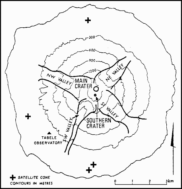 |
Figure 1. Sketch map of Manam Island, after Palfreyman and Cooke (1976). |
Volcano-seismic events normally occur at the rate of about 1 per minute beneath Manam. Minor eruptive phenomena occur intermittently between major eruptions (such as 1974-1975). [2:4 erred in adding that these phenomena were usually confined to Main Crater.]
Reference. Palfreyman, W.D., and Cooke, R.J.S., 1976, Eruptive history of Manam volcano, Papua New Guinea, in Johnson, R.W. (ed.), Volcanism in Australasia: Elsevier, Amsterdam, p. 117-131.
Information Contacts: R. Cooke, RVO.
Weak ash emission of last year ended
A long phase of relatively weak ash ejection from Southern crater in 1977 ended in mid-January 1978. Similar activity briefly resumed at the end of February and for a few days in mid-March. Emission of moderate amounts of white vapor from Main and Southern craters has occurred since then.
Information Contacts: R. Cooke, RVO.
Occasional minor ash ejection continues
Minor ash ejection from Southern crater has been reported at intervals since mid-March: on 8 and 19-20 June; 11-13, 16-17, 19, and 27 July; 24, 26-28, and 31 August; and 2, 8-11, 14-16, and 18-22 September. Ashfall has been noted a number of times, particularly since mid-September.
Information Contacts: R. Cooke, RVO.
Ash ejection begins from Main Crater and continues from South Crater
Small amounts of ash were emitted from Southern crater on most days in October. Incandescent fragments were seen briefly on 3 nights. Ash ejection from Main crater began in mid-October, and glow was seen there late in the month.
Information Contacts: R. Cooke, RVO.
Ash emission more frequent; glow often visible
Intermittent ash emission from Southern crater was less frequent in November and early December than in October. Ejection of incandescent lava fragments was seen on seven nights in November and glow was observed on seven nights in mid-December. For most of the second half of December, white and occasionally blue vapor issued from Southern crater. Ash ejection from Main crater was reported on 9, 13, 22, and 29 November, and on 6 December. Glow was seen over Main crater on 11 November, and 17, 21, and 23 December.
Information Contacts: C. McKee, RVO.
Stronger incandescent eruptions
"Eruptive activity strengthened in August and it appears that the level of lava has risen within the volcano. Glow was visible above both Main and Southern craters on most nights, and ejections of incandescent lava were observed on several nights. The lava ejections were stronger from Main crater, rising occasionally 200-300 m above the summit. Brown ash was emitted from Main crater on many days and grey ash emissions were seen rarely. Southern crater discharged brown or grey ash on only a few days. Otherwise both vents released white and blue vapours. Eruptive sounds included rumbling, roaring, booming, and sharp detonations. Seismic activity showed a slight intensification, but tilts were steady.
"An aerial inspection was made on 19 August. Main crater was a circular pit several hundred meters wide and contained a broad mound of black lava (fragments?). The surface of the mound was about 50-80 m below the crater rim. A central, circular vent was discharging blasts of red incandescent lava fragments at 1-10 second intervals. Southern crater was a deep, funnel-shaped structure with a pool of red incandescent lava at its base. Copious quantities of blue vapour were being released from both craters at the time of the inspection."
Information Contacts: C. McKee, RVO.
Activity declines
"The period of strong eruptive activity that developed at the beginning of August terminated on 24 August, and the level of B-type seismic activity dropped back to that of July. Observations were infrequent during September because of bad weather but it is likely that emissions from both Main and Southern craters consisted solely of vapor. Weak glow from the summit was seen on 2 nights. The only audible effects were weak roaring noises."
Information Contacts: R. Almond, RVO.
Ash emission and glow
"During the reporting period 12-22 October, white vapour was emitted from both Main and Southern craters. Additionally, Main crater released grey ash on 13 October and brown ash 16-18 October. Glow was seen from both vents on most nights during the reporting period, and sparse lava ejections from the Southern crater were seen on the 16th. Roaring and rumbling noises were heard 13-15 October. There appeared to be no trend in tilt, and seismic activity remained steady at the same level as in September. Reports from Manam have been interrupted by the breakdown of Tabele Observatory's electrical generators.
"A brief aerial inspection on 26 October revealed that only thick white vapour emission was occurring at both vents. No clear views into the Southern crater were obtained, but a dark surface of lava (fragments?) was seen in Main crater."
Information Contacts: C. McKee, RVO.
Ash emission and occasional lava ejection
"Moderate activity occurred in January and February. Grey ash emissions from Southern crater were seen commonly in mid-January together with crater glow and occasional lava ejections. Activity weakened somewhat in February when mostly white and blue emissions were seen, and glow, with or without lava ejections, was seen on 7 nights evenly distributed through the month. Main crater was usually obscured, but grey or brown ash emissions were seen sporadically in mid-January. No sounds of eruptive activity from either vent were heard in the 2-month period."
Information Contacts: C. McKee, RVO.
Lava ejections and glow
"During March, Manam's summit was often obscured by clouds, but when visible, both vents were usually emitting white vapours. Weak rumbling noises were heard on the E side of the volcano on 7 March. Activity strengthened in April, when glow and lava ejections from Southern crater were commonly seen. The highest ejections rose to about 50-60 m above the summit. No eruptions of ash were seen, but white and blue vapours were emitted. A blue haze was occasionally seen in the upper parts of some of the major valleys that descend from the summit. Main crater was usually obscured, but white emissions were observed on a few days. Seismic activity remained at its usual level and tilt readings indicated no trends."
Information Contacts: C. McKee, RVO. [Information Contacts for this and following RVO reports were corrected by the RVO staff in January 1988.]
Ash emission and increased seismicity
"Activity strengthened near the end of the first week in May. Brown or grey ash emissions from Southern crater were observed on most days in May, and grey ash emissions from Main crater were also observed on several days when the vent was not obscured. Light ashfalls were experienced on the W side of the island. This ash emission often occurred with little accompanying sound. However, deep booming, rumbling, and roaring noises were occasionally heard. Orange-red glows above both vents were seen on a few days, and lava fragment ejections from Southern crater were observed on 1 and 18 May. No trends were observed in tilts, but seismic amplitudes increased by a factor of about two over normal levels at the onset of the phase of ash emission."
Information Contacts: C. McKee, RVO.
Activity declines to ocasional ash emission
"Manam's activity returned to a lower level in June. Occasional brown or grey ash emissions from Southern crater were observed, and light grey emissions from Main crater were seen on 5 June. However, no explosive sounds and no glows were observed from either crater. No trends were registered by the tiltmeters, and seismicity remained at its normal level."
Information Contacts: C. McKee, RVO.
Mild ash emission and occasional rumbling
"Manam's July activity was at a level similar to that of June, although brief periods of stronger seismicity were recorded at the beginning and end of the month. Pale grey/brown or thick white emissions from Southern crater were commonly observed, and blue vapours were occasionally seen. Main crater was often obscured but several observations of pale grey/brown emissions were made. Occasional rumbling sounds were heard, but no crater glows were seen. No trends were registered by the tiltmeters."
Information Contacts: C. McKee, RVO.
Ash emission continues
"Activity during August continued at the same level as that of June and July. Emissions from Southern crater were mostly white vapour and brown ash, but grey ash emissions were observed on 20 August and blue vapours were occasionally seen. Roaring and rumbling sounds were associated with stronger pulses of ash emission. Main crater was obscured most of the time, but on several occasions white vapour emissions were observed. Brown ash emissions from Main crater were observed on 20 August. No crater glows or lava fragment ejections were observed from either crater. Seismicity and tilt remained steady."
Information Contacts: C. McKee, RVO.
Occasional ash emission
"Activity continued at the same level as that of the previous 3 months. Southern crater usually emitted white vapour, but brown, grey, or blue emissions were occasionally seen. Weak rumbling noises were heard on a few days at the beginning of September. Emissions from Main crater were usually white, but grey emissions were seen on two occasions, on 2 and 10 September. No glows or lava fragment ejections from either crater were observed. Seismic activity and tilts were steady."
Information Contacts: C. McKee, RVO.
South vent glows, emits ash
"Moderate to strong light brown to grey ash-laden vapour and, rarely, dark brown dust were sporadically ejected from Southern crater. Main crater occasionally emitted weak white vapour. Light ashfall from Southern crater was recorded at nearby Tabele on 2 December. Low rumbling noises were heard on 20 and 25 December. A weak glow from Southern crater was observed at night 26-29 December. Seismic activity was at its normal level. [Tilt measurements indicated radial inflation of about 3 µrad in December. This followed a net inflationary radial tilt of about 2 µrad in October.]"
Information Contacts: B. Talai and P. Lowenstein, RVO.
Ash emission, seismicity, and inflation increase
"During the first 2 months of 1981 a low level of activity prevailed. White and occasionally brown emissions were observed from both craters. In March, moderate to strong brown and light grey ash-laden emissions were common from Southern crater. Main crater emissions were also grey on several occasions. Explosive sounds from the summit were rarely heard in January and February but became noticeable in the second half of March. Night observations of the volcano in January and February indicated no lava fragment ejections above the craters, although weak glow above Southern crater was reported for 2 January. Sparse ejections of lava fragments from the crater were observed overnight on 14-15 March, and glow above Southern crater was observed on 30 March.
"Background volcano-seismic levels remained fairly steady January-March, but a significant change in seismic activity was the occurrence of strong local earthquakes, possibly of volcanic origin. Preliminary analysis of seismic records showed that five such events were recorded in February and 14 in March.
"The tiltmeters at Manam continued to show a trend of northerly uplift. After the last major eruptive period in 1974 a pattern of summit deflation prevailed until early 1978. Total deflation was about 14 µrad. A definite trend of inflation began in the second half of 1979. The accumulated tilt during the last 2 years was about 6 µrad.
"Aerial inspections were made on 6 and 19 March. Cloud cover prevented detailed observations of summit activity on 6 March but a distinct blue vapour haze was drifting down the N and NW flanks. On 19 March, brown ash-laden ejections from Southern crater were occurring at about half-minute intervals. Main crater continuously released white vapours. Again a blue vapour haze was present, extending about 1 km N of the summit."
Information Contacts: C. McKee, RVO.
Ash and incandescent lava fragments
"Visible activity intensified somewhat in April. On most days when the summit was not obscured, moderate volumes of variously white, and light to dark brown or grey emissions were seen rising above Southern crater. Occasional rumbling, roaring, and booming noises from the summit were heard at Tabele Observatory (about 4 km away). A weak glow above Southern crater was seen on 13 and 16 April, and ejections of incandescent lava fragments from there were seen on 28 and 29 April. Main crater was usually obscured, but thick white emissions were noted on 7 and 28 April. The intensity of background volcano-seismicity remained steady. A preliminary analysis indicates that only one A-type volcanic earthquake occurred in April. Tilt measurements were steady."
Information Contacts: C. McKee, RVO.
Ash ejection and glow
"Activity was fairly stable during May. Southern crater released white vapours and emitted moderate volumes of brown and grey ash. Main crater was usually obscured, but in clear conditions it was seen to release thick white vapours. Main crater glow was seen on several nights 20-23 May. Rumbling and booming noises from the summit were heard occasionally. Background seismic activity and tilts remained steady."
Information Contacts: C. McKee, RVO.
Ash emission continues; rumblings
"Activity in June was similar to that observed in May. Southern crater continued to emit white vapours and brown to grey ash in moderate volumes. Main crater usually released thick white vapours. Low rumbling sounds from the summit, heard frequently during the second half of the month, probably originated from Southern crater. No summit glows or incandescence were observed. A light ashfall was recorded at Manam's [Tabele] Observatory, about [4] km from the summit, on 4 June. Seismic activity and tilts remained steady."
Information Contacts: C. McKee, RVO.
Ash emission continues
"Visible activity in July remained similar to that observed in June. Emissions from Southern crater varied between white, brown, light grey, and dark grey. Main crater released grey emissions on several days. Occasional weak rumbling sounds, and deep booming sounds on 30 July, probably originated from Southern crater. No observations were made of summit glow or ejections of incandescent lava fragments. Occasional ashfalls were registered on the SW to NW flanks. Seismic activity and tilts showed no significant changes from previous trends [but see 6:8]."
Information Contacts: C. McKee, RVO.
Incandescent lava, glow, sounds
"Brown or grey ash emissions from Southern crater were seen less frequently in August than in July. Main crater usually released white vapours, but grey or brown ash emissions were more common in August than at other times in 1981. Sound effects from the volcano ranged from weak rumbling to loud deep booming. Static dull orange-red glow at both craters overnight on 31 July-1 August was occasionally disturbed by flashes of bright orange-yellow glow, and sprays of incandescent lava fragments from Southern crater were also seen occasionally. Glow and ejections of incandescent lava fragments from Southern crater were observed 14 July, and glow from Main crater was seen on the 25th.
"Detailed analysis of seismic records indicates that, contrary to reports for June and July (SEAN 06:6-7), seismicity began a slight but apparently steady intensification in early June. For most of August, average seismicity was probably twice as strong as in the first half of 1981. The character of seismicity, however, is unchanged, and consists of volcanic B-type or explosion earthquakes. Tilt observations were steady in August."
Information Contacts: C. McKee, RVO.
Incandescent tephra ejected; ash emission and seismicity decline
"There were fewer instances of ash emission from both craters in September. Usually, Southern crater released moderate volumes of thick white vapour. However, rumbling sounds from the volcano were common, and weak glow and ejections of incandescent lava fragments from Southern crater were observed on 15 September. No trends were evident from tiltmeter measurements. Seismicity remained at a level higher than normal for most of the month, but declined near the end of the month to levels prevailing in the first half of 1981."
Information Contacts: C. McKee, RVO.
Incandescent tephra, glow, ash plume
"Both craters showed stronger activity in October. Incandescent tephra ejections from Southern crater were seen on four nights at the beginning of the month, and on most nights from 12 October onwards. Brown or grey ash emissions from Southern crater were seen 1-9 and 21-30 October. Main crater emitted brown or grey ash on most days 1-22 October. Main crater glow was seen on 1 October, and incandescent tephra ejections on the 14th. A substantial ash plume from Main crater (reportedly several tens of kilometers long) was observed on 14 October. White and blue vapours were emitted from both craters during non-explosive intervals throughout October, and rumbling sounds from the volcano were heard on most days. No trends were shown by tiltmeter measurements, and seismic activity remained steady."
Information Contacts: C. McKee, RVO.
Incandescent tephra; ashfalls
"Visible activity appeared to intensify somewhat in November. Brown or grey emissions from Southern crater were observed on most days, and crater glow or ejections of incandescent tephra were seen on most nights. Sound effects associated with this activity varied from low rumbling to thudding, booming, and occasional detonations. Ashfalls in coastal locations 4-5 km from the summit were reported early in November. Main crater was less active, usually emitting white vapours, although grey and brown emissions were observed on 2 days late in the month. Instrumental readings remained steady."
Information Contacts: C. McKee, RVO.
Explosions and seismicity intensify
"Activity further intensified in December. Southern crater emissions became darker after 9 December when spearheaded projections of tephra were first reported. Rumbling, thudding, and roaring sounds also intensified after the 9th. Larger tephra was visible beginning 13 December. Incandescent tephra ejections were seen throughout the month. Daytime incandescence, visible from Tabele Observatory (4 km from the summit), was reported occasionally, but became more common at the end of the month. These ejections rose to a maximum height of about 0.7 km. Spearheaded tephra projections became common at the end of the month. Light ashfalls in coastal areas 4-5 km from the summit were reported on several days in the second half of the month.
"Main crater was less active than Southern crater. Weak to moderate volumes of brown to grey emissions were reported occasionally in the first 10 days of December. However, activity intensified later in the month, and tephra emissions were reported every day 21-30 December. Weak glow from Main crater was seen on 29 December. Seismicity strengthened throughout December, reaching August and September levels by the end of the month. Distinct inflation was evident from tiltmeter measurements."
Information Contacts: C. McKee, RVO.
Incandescent tephra, ashfalls; inflation
"Dark tephra emissions from Southern crater continued throughout January, although periods of white vapour emission became more common from the 16th. Roaring, rumbling, booming, and thudding sounds were more pronounced in the first half of the month. Incandescent tephra ejections were seen on most nights, occurring at intervals of 1-3 minutes. Ashfalls were reported on the E coast of Manam 7-15, 21-22, and 29-30 January.
"Activity at Main crater was subdued, consisting of weak white and brown emissions. Seismicity declined from a peak between mid-December and early January, and by mid-January seismicity was back to normal levels. Tilts were stable during January following the inflationary phase of December 1981."
Information Contacts: C. McKee, RVO.
Tephra ejections, ashfalls; increased seismicity
"Weak to moderate ejections of grey or brown tephra from Southern crater were observed on most days. Frequency of eruptions varied, and occasionally they resembled Strombolian activity. Incandescent tephra ejections were visible on the nights of 6, 10, 11, 14, 15, and 17 February. Ashfalls in coastal areas were reported on most days 1-20 February. The only emissions observed from Main crater were white vapours. Seismicity increased during February, and by the end of the month the level was similar to peaks reached in August-September and December 1981. Tilts remained stable."
Information Contacts: C. McKee, RVO.
Strong explosions; pyroclastic flow; seismicity
"Strong eruptive activity occurred in 2 intervals in March, the first during several days at the beginning of the month. Spearheaded projections of tephra from Southern crater were observed on 2 and 3 March. Tephra ejections were less intense 4-7 March, but instability of the rapidly accumulated tephra caused avalanches of this material to descend from the summit into the SW valley. Inspections by volcanologists on 10 and 11 March suggested these avalanches were small. No significant changes in tiltmeter readings accompanied this eruptive phase, but seismicity showed a marked intensification on 5 March.
"Much stronger activity occurred near the end of the month. A paroxysmal eruption was observed at 1207 on 27 March. The dark grey-brown Vulcanian eruption cloud ascended to 6-7 km. Lightning flashes were seen in parts of the cloud. Strong Strombolian explosive activity followed the paroxysmal eruption at about 1215. The E side of the island experienced a brief period of darkness and tephra falls were locally severe, but the maximum thickness of the tephra deposit was probably only a few mm. Fragments up to 7 cm in size were collected at one village. Vegetation was strongly affected by the tephra fall and water supplies were polluted, but no structural damage was done to houses. A pyroclastic flow descended the SE valley during the eruption, but stopped about halfway to the coast.
"Seismicity was very strong at the time of the eruption and was still high at month's end. Before and after the eruption discrete B-type earthquakes occurred at the rate of about 1 per minute. For about 15 hours from the commencement of visible activity, discontinuous seismic tremor was recorded. No significant changes were evident in tiltmeter readings."
Information Contacts: C. McKee, RVO.
Smaller explosions; earthquakes and harmonic tremor
"Activity was weaker in April. Southern crater was relatively quiet for most of the month, emitting brown-grey tephra clouds of small to moderate volume. However, 2 discrete explosions were observed on 24 and 25 April, with clouds reaching heights of about 600 m and 1500 m respectively. Main crater was reactivated on about 10 April when small grey tephra clouds were observed. The period of strongest activity was 15-20 April and included louder explosive sound effects, increased emission of tephra, and incandescent tephra ejections to about 130 m. Seismic activity was generally low, but higher 15-20 April. A change in the character of the seismicity, from discrete events occurring at rates of several per minute to more or less continuous tremor, was noticed 7-15 April. A rapid intensification in seismic amplitude occurred 15-18 April, and an abrupt decrease took place after the 20th. No significant variations were registered by the tiltmeters."
Information Contacts: C. McKee, RVO.
Ash emission; slight inflation
"After reactivation of Main crater on 10 April, moderate volumes of dark grey-brown ash-laden emissions from this crater continued to be observed on most days in May. This activity was stronger in the first half of the month when roaring, rumbling, and explosion sounds accompanied the ash emissions. Fine ashfalls, probably from Main crater, took place on the E coast on 11, 13, 14, and 16-17 May. No crater glows or incandescent tephra ejections from Main crater were seen in May.
"Southern crater showed a low level of activity throughout May, releasing small to moderate volumes of grey-brown ash-laden emissions on most days. Blue vapour emissions were common. Weak crater glow was observed occasionally from the 14th.
"Seismicity was at a low (normal) level throughout May. Tilt measurements were steady in the first half of the month, but a slight inflation (about 1 µrad accumulated during the second half."
Information Contacts: C. McKee, RVO.
Ash emission; weak seismicity; minor deflation
"Fairly steady levels of activity prevailed at both craters in June and July. Southern crater has released moderate volumes of grey-brown ash-laden emissions and occasionally blue vapours. Rumbling and roaring sounds accompanying these emissions indicated a relatively mild eruptive condition. No glows from this crater were seen in June or July.
"Main crater emitted grey to dark grey and rarely brown ash clouds in usually moderate volumes, also accompanied by roaring and rumbling sounds. Crater glows were seen on 18 June and 17 July. Light ashfalls in coastal areas (about 5 km from the craters) were reported on 28 June and 14, 15, 17, 18, and 24 July. A persistent blue vapour haze on the upper flanks of the volcano was observed on 19 and 24 June and 6, 11, and 30 July.
"Seismic activity was remarkably steady in June and July at a low level. The tiltmeters at Tabele Observatory on the SW side of Manam have registered 3-4 µrad of northerly down-tilt since early March."
Information Contacts: C. McKee, RVO.
Ash clouds, glow at main crater; increased seismicity
"Main crater erupted impressively from 8 August when thick dark grey ash clouds were emitted and weak to strong crater glow was observed at night. Sharp ejections were seen occasionally. Rumbling and roaring sounds accompanied similar activity until a decline became evident on 23 August. Voluminous blue vapour emissions were seen on several days between 19 and 31 August. Ashfalls in coastal areas were reported on about 30% of days, evenly distributed throughout the month.
"Southern crater activity was very mild during the first half of August. An increase occurred in the second half of the month, and weak to moderate pale grey-brown ash emissions were reported on most days after the 14th. On a few days at mid-month, weak to strong roaring and rumbling sounds were heard from this crater. No Southern crater incandescent activity was observed."
Information Contacts: C. McKee, RVO.
Main crater explosive eruption subsides
"The impressive Main Crater eruption which began 8 August continued until about 13 September. Eruption sound effects of weak to strong rumbling declined after 10 September, and ash emission which had been moderate to strong early in the month waned after the 11th. Crater glows and occasional sprays of incandescent tephra were observed on nights at the beginning of September but ceased after the 13th. Steady, weak to moderate ash emission continued, however, from 14 September. Occasional blue vapour emissions from the main crater were observed throughout the month. The S crater released pale grey emissions at a moderate rate for most of September, but intensified activity was evident from the 23rd when ash emission became stronger, more dense, and took on a grey-brown colour. Sound effects of low rumbling were associated with the stronger explosive activity. no crater incandescence was seen, however blue vapour emissions were common from 13 September. Ashfalls in coastal locations were generally light and were reported during 1-12, 18, and 27-30 September.
"Slight changes were registered by the tiltmeters at Tabele Observatory on the SW flank of the volcano. These indicated an uplift of less than 1 µrad to the NW from Tabele. Amplitudes of B-type volcanic shocks were fairly steady at about twice non-eruptive levels until 21 September, when the amplitudes dropped sharply. For the remainder of the month seismicity was at non-eruptive levels. These changes show poor correlation with observed activity."
Information Contacts: P. Lowenstein, RVO.
Ash emission; weak glow
"Little change was noted in the mode of activity in October compared with activity in the second half of September. Both craters continued to produce pale, dark grey and brown ash-laden emissions in moderate quantities. Occasionally, an eruption column 0.5-1 km high was formed. Rumbling sounds were commonly heard coming from the S crater and occasionally from the main crater. The only instances of crater incandescence were observations of weak glow from the S crater on 13 and 14 October.
"Ashfalls were reported from the Sw and E coastal areas, about 5 km from the summit, on about 50% of days. Tiltmeter measurements showed no trends, and seismicity remained at a fairly low level."
Information Contacts: C. McKee, RVO.
Steady, moderate activity; light ashfalls
"Both craters displayed steady, moderate levels of activity in November. Southern crater was somewhat more active with rumbling sounds commonly accompanying the usually pale grey to brown ash-laden emissions. Main crater emissions were usually white and pale grey, but occasional brown ash-laden emissions were seen. Light ashfalls were reported in coastal parts of Manam on most days in November. No crater incandescence was observed. Seismic activity was steady at normal levels throughout November, and tiltmeter measurements showed no trends."
Information Contacts: C. McKee, RVO.
Light ashfalls; increased seismicity
"Both craters displayed a moderate level of activity through December. A moderately thick white to grey plume was released from Main crater while Southern crater produced grey to brown ash-laden emissions. These emissions, accompanied by weak and low rumbling noises, resulted in occasional light ashfalls on coastal parts of the island.
"The level of seismicity increased during the month (number of recorded shocks from 1,500 to 2,000/day; background tremor becoming continuous from 19 December). The average amplitude of the seismic events increased on 13-17 December and again on 27-28 December. Emissions from Main crater increased in volume and pressure, but instead of explosions or crater glow the seismic activity dropped again suddenly (from 2,200 on 28 December) to a low level and tremor stopped."
Further Reference. Scott, B.J., and McKee, C.O., 1984, Deformation, earth tidal influences, and eruptive activity at Manam volcano, Papua New Guinea, 1957-82: Geological Survey of Papua New Guinea Report 84/3.
Information Contacts: P. de Saint Ours and P. Lowenstein, RVO.
Little volcanic activity; steady, moderate seismicity
"Manam Volcano was essentially quiet during January. Moderately thick white vapour was released from Main crater, and a white-grey plume from the Southern crater. Hardly any noise was heard. Only very light ashfalls were reported from downwind coastal areas of the island. Seismic activity remained steady, with about 2,000 moderate-amplitude events recorded per day. Tilt curves at both stations remained flat."
Information Contacts: P. de Saint Ours and B. Talai, RVO.
Rumblings, night glow, increased vapor emissions
"Main crater [experienced increased activity] for a few days in mid February. Ash-laden emissions from Southern crater also increased.
"White vapour was first observed over Main crater 8 February and increased on the 9th. This was accompanied by a change in the seismic pattern, with a progressive decrease in the daily number of B-type events (from 2100) but an increase in amplitude of the shocks.
"Activity stayed at low level until 15-16 February, when low to loud rumbling noises from Main crater were heard at 5-minute intervals. Harmonic tremor, formerly in bands, became continuous. Large amounts of blue vapour were observed with the white plume. On the night of 16 February red glow was seen over Main crater. The activity lasted 4 days and was accompanied by an increase in the daily number of recorded seismic events from 1400 to 1800.
"Beginning 20 February, night glow and blue vapour emissions disappeared, and rumbling noises and plume volume decreased. In the last days of the month seismic activity fluctuated between [1100] and 1300 daily events, but some explosions from Southern crater were again heard and recorded."
Information Contacts: P. de Saint Ours and P. Lowenstein, RVO.
Explosions, ash emissions, and seismicity increase
"Southern crater became more active in March after showing increasing activity in late February. Weak explosion sounds were heard on most days until 14 March, accompanying weak to moderate white-grey vapour and ash emissions. Weak ejections were reported on 12 and 13 March, when weak crater glow was seen. A period of somewhat stronger emissions was reported 19-24 March, including low to moderate explosion sounds on 23 and 24 March, and continuous vapour and ash emissions were noted on 26 and 29 March. Weak rumbling was heard from the 29th to the month's end, and deep booming sounds were reported on the 31st.
"Generally steady activity of weak to moderate white-grey emissions occurred at Main crater until about 23 March. These emissions were usually not accompanied by sound effects, but on 2 and 3 March weak explosion sounds were heard. From the 24th to the end of the month emissions were reported to be moderate, and included brown ash from the 27th. Light ashfalls were reported on about 30% of days from locations on the E and SE flanks.
"A steady increase in the daily number of volcanic earthquakes took place in March, from about 1200 at the beginning of the month to about 2100 at month's end. Event amplitudes showed a slight stepwise increase at mid-month. A marked brief increase in seismic amplitudes was also noted on 4 and 5 March.
"Tilt measurements showed steady changes of about 1 µrad down to the NW from the observatory, on the SW flank (figure 1)."
Information Contacts: C. McKee, RVO.
Vapor emissions, detonations, glow, ashfalls
"A slight intensification of the ongoing mild eruptive activity was evident in April. Increased seismicity and continuous, voluminous blue vapour emissions occurred at both summit craters from mid-month. Both craters continued to emit pale grey or brown ash clouds that reached maximum heights of about 1000 m above the summit. Emissions from Southern crater were accompanied by sharp detonations, booming, and rumbling of varying intensities, at intervals of 5-25 minutes. Similar sound effects from Main crater were occasionally heard.
"Southern crater glow was seen on most nights in the month, although a hiatus occurred 14-16 April. Ejections of incandescent lava that reached maximum heights of about 250 m above the crater were seen on about 30% of nights. Weak or fluctuating Main crater glow was observed 5-8 and 14-19 April. Ashfalls were recorded in coastal areas, about 5 km from the summit, on about 35% of days.
"No significant tilt changes were recorded in April, but seismicity showed a mild intensification. Seismic amplitudes increased near the beginning of the month and remained double normal size. Daily earthquake totals varied from 2500 at the beginning and end of the month to a peak of 3500 on 23 April."
Information Contacts: C. McKee, RVO.
Seismicity, ash emission, incandescence intensify
"Further intensification of activity in May was shown by increased seismicity, stronger ash emissions, and more frequent sightings of nighttime incandescence.
"Both craters continued to emit pale grey ash clouds, but the emissions from Southern crater were frequently reported to be strong and thick. The emission column from Southern crater usually rose several hundred meters above the summit, and a plume several tens of kilometers in length was reported on a few days. Intervals between discrete explosion and rumbling sounds varied from about 3 to 35 minutes. Glow and incandescent lava ejections were observed on most nights. Ballistic trajectories of incandescent tephra reached heights of up to 600 m above the crater rim.
"A brief period of intensified Main crater activity took place 12-19 May. Stronger ash emissions were accompanied by explosion and rumbling sounds, and crater glow and incandescent lava ejections were reported 12-16 May. Incandescent tephra fragments reached a maximum height of about 500 m.
"Volcano-seismic amplitudes continued to increase from the elevated April levels and reached a peak of about 5 times normal 22-24 May. A slight reduction was evident during the last week of May. At the month's end, amplitudes were still about 3 times normal. The number of volcano-seismic events declined from the peak of about 3500 per day reached in late April, and stabilized at about 2500 per day in May.
"A small but distinct tilt change was evident in May on the E-W component of the water tube tiltmeters at Tabele Observatory, about 4 km SW of the summit. The amplitude of the change was about 1 µrad, and its orientation was consistent with inflation of the volcano. No corresponding changes were shown by the N-S component."
Information Contacts: C. McKee, RVO.
Seismicity stays high; emissions, noises lessen
"Despite continuing high levels of seismicity, audible and visible activity tended to be less intense in June. Both craters produced pale grey ash-laden emissions in moderate volumes, accompanied by rumbling and booming sounds at intervals of 3-25 minutes. Most of the sounds seemed to originate from Southern crater.
"Blue vapours were also emitted from both craters, but particularly from Southern crater, resulting in a haze of blue vapour on the downwind flank of the volcano. Probably as a result of strong winds, the emission column rarely rose higher than about 100 m above the summit. On several days the bluish emission plume stretched out for several tens of kilometers. Fallout of ash was common in coastal areas, but usually light.
"Daily totals of volcanic earthquakes rose from about 2,400 at the beginning of the month to about 2,900 at the month's end. The amplitudes of discrete volcanic earthquakes were about three times normal at the beginning of the month, but rose to about five times normal 11-24 June. By month's end amplitudes had returned to early June levels. Tiltmeter measurements showed no trends in June."
Information Contacts: C. McKee, RVO.
Moderate ash, vapor emissions; B-type events continue
"Most observed parameters showed little or no change in July. Visible activity at Southern crater was unchanged from that of June: pale grey ash-laden emissions in moderate volumes ejected to no more than about 100 m above the crater rim. Occasional weak rumbling and booming sounds accompanied these emissions. Blue vapour emissions also continued at the same rate. On several days a bluish emission plume stretched several tens of kilometers downwind. The crater was often obscured at night, and incandescence was seen only on the nights of 2, 4, 12, and 13 July, as weak fluctuating glow. On 2 July ejections of incandescent tephra to heights of about 250 m were also seen.
"Main crater activity was weaker in July than in June. Usually, pale grey ash-laden clouds were emitted in small to moderate volumes. Blue vapour emissions were seen on 12 and 14 July, and 26-31 July. No eruption sounds could be detected from Main crater, and no instances of nighttime incandescence were reported.
"A helicopter inspection on 26 July revealed that Main crater was a deep funnel-shaped structure having a central vent from which weakly ash-laden, blue-tinged clouds were being released. Abundant fumaroles were noted on the crater walls. Views of Southern crater were obscured by steady emission of ash-laden clouds that filled the entire crater.
"Amplitudes of B-type volcanic earthquakes were remarkably steady throughout July at about double non-eruptive levels, but representing a distinct decline from the high levels of mid-June. Daily totals of seismic events were about 2,000 at the beginning and end of the month, but varied up to about 3,000 in mid-month. Tilt measurements showed a continuation of the flat trend evident in June."
Information Contacts: C. McKee and P. de Saint Ours, RVO.
Emissions increase slightly; B-type events continue
"A slight intensification of the moderate eruptive activity at Southern crater took place in the second half of August. Activity at Main crater remained essentially unchanged from July. In the first half of August a pale grey or brownish plume of moderate volume was produced at Southern crater, accompanied by blue emissions. Similar emissions were released from Main crater, although in lesser amounts. Seismic recordings in this period indicate a daily average of about 2,000 B-type earthquakes of small amplitude.
"From about 16 August, brown or dark grey ash clouds were ejected from Southern crater. These convoluting ash-laden clouds usually rose 100-200 m over the crater rim. Daily totals of B-type earthquakes increased to as many as 2,800 events, of slightly larger amplitude. Crater glow and sprays of incandescent lava fragments were observed on 27 and 28 August, rising to 150-200 m above Southern crater at 2-3-minute intervals. Weak glow at Main crater was observed on 28 August. Near the end of the month the daily totals of B-type events declined to about 2,300. No significant tilts were registered by the water-tube tiltmeters at Tabele Observatory."
Information Contacts: C. McKee and P. de Saint Ours, RVO.
Four days of stronger activity, ashfalls to 10 km
"Apart from a short period of stronger activity at mid-September, Manam continued its mild eruptive activity which has been characterized by moderate emissions of pale grey-brown ash clouds from both craters. The stronger activity occurred 10-13 September, when impulsive ejections of dark tephra-laden clouds took place from Southern crater at intervals of several minutes. The ejections rose to 150 m above the crater and fed a plume that extended several tens of kilometers downwind. However, this stronger activity had no distinctive seismic expression. Throughout the month amplitudes of volcanic earthquakes remained steady at 2-3 times normal, and the average daily total of events was about 2,500. Tilt measurements from Tabele Observatory indicated a gradually accumulating [upward tilt] of about 2 µrad to the NNW."
Richard Stoiber, Stanley Williams, and Chris McKee used a COSPEC to measure the rate of SO2 emission from several volcanoes in Papua New Guinea during September (table 1). Plumes at and Manam were strong, and plume was small. Activity at Langila was weak 11 September, but had intensified during measurements the next day. The quiet-phase data were collected from the ground; all other data were acquired while flying under the plumes.
Table 1. Rates of SO2 emission at Bagana, Langila, Manam, and Ulawun, Papua New Guinea, September 1983. Airborne COSPEC data from R. Stoiber, S. Williams, and C. McKee.
| Date | Volcano | SO2 t/d |
| 08 Sep 1983 | Bagana | 3,100 |
| 11 Sep 1983 | Langila | 74 |
| 11 Sep 1983 | Ulawun | 71 |
| 12 Sep 1983 | Langila | 1,300 |
| 12 Sep 1983 | Manam | 920 |
Information Contacts: C. McKee, RVO; R. Stoiber and S. Williams, Dartmouth College.
Tephra clouds; glow; rumbling; increased seismicity
"Activity intensified somewhat at Manam's Main crater in October, while Southern crater activity was generally mild with forceful ejections of tephra on 2 days. The intensified Main crater activity took place in several brief periods. Explosive eruption sounds (rumbling, roaring, and booming) were heard about 4-5 km away on 14-15, 23-25, and 29-31 October, and crater glow was seen on 14, 23-24, and 29-30 October. Moderate, pale grey-brown emissions were observed during these periods, but at other times only small to moderate amounts of tephra-poor vapour were emitted.
"For most of the month, Southern crater emissions consisted of pale grey-brown ash clouds, but on 16 and 31 October impulsive, dense ejections of tephra and vapour to 200-250 m above the crater occurred. On 20, 22, and 31 October the emissions from both craters combined to form a plume several tens of kilometers long.
"Amplitudes of volcanic earthquakes were mainly steady at about 2-3 times normal levels, but increased 15-25 October. Daily earthquake totals remained around 2,700 for the first half of the month, decreased to about 1,900 at mid-month, and approached 2,600 on 31 October. A small down-tilt of about 1 µrad to the N (deflation) accumulated steadily during the month."
Information Contacts: C. McKee, RVO.
Emissions increase; fewer but stronger earthquakes
"Activity at Manam's Main crater showed a further intensification in November but Southern crater activity remained mild. The stronger Main crater activity commenced about mid-month, and was marked by moderate to strong, pale grey-brown tephra-laden emissions, accompanied by louder rumbling and roaring sounds, and a doubling of the amplitudes of explosion and B-type volcanic earthquakes. Daily totals of earthquakes showed a corresponding decrease from about 2500 to 1500. No significant tilting accompanied the intensified eruptive activity. Fluctuating or dull glow from Main crater was seen occasionally throughout the month. Southern crater continued to release emissions that usually contained little or no tephra. Weak rumbling or roaring sounds were heard occasionally. Blue vapours were emitted from both craters on most days of November."
Information Contacts: C. McKee, RVO.
Glow, tephra ejection, explosions at summit craters
"The moderate level of activity from Main crater reported in November decreased early in December. After a comparative lull 3-13 December, vapour emission from Southern crater increased, and from the 17th onwards night glow and ejection of incandescent fragments were observed. Glow from Main crater was also observed from 18 December onwards. The combined activity was accompanied by deep rumblings, explosion noises, and the discharge of a moderately large, strongly coloured, ash-laden vapour plume. Light ashfalls were experienced daily on the SW side of the island for the remainder of the month."
Information Contacts: P. Lowenstein, RVO.
Strombolian activity; explosion cloud to 3.5 km
"The eruptive activity continued through January. It consisted of night glow at both Main and Southern craters, and frequent Strombolian ejections of glowing lava fragments up to several hundred meters above Southern crater. Explosion noises and sub-continuous rumbling sounds were heard. Scoria and bombs ejected from Southern crater avalanched down the SW and SE valleys.
"Beginning 13 January, the amplitude of recorded B-type earthquakes started to increase considerably, although their number remained about 2,000/day. From 18-26 January, the amplitudes of events increased to about four times normal. At 1155 on 26 January, a large explosion from Southern crater produced a voluminous, dark ash-laden plume rising to 3.5 km. The amplitude of the sub-continuous tremor and B-type events then returned rapidly to normal. Up to 3 mm of ash were deposited on the coastal areas. For the remainder of January, the Strombolian activity continued at the same level as at the beginning of the month."
Information Contacts: P. Lowenstein, RVO.
Pyroclastic avalanches, scoria flows; eruption columns to 5-8 km; stage-1 alert in force
"A phase of major eruptive activity commenced at Manam's Southern crater in mid-February when a series of pyroclastic avalanches was discharged into the SE valley. Moderate Strombo-vulcanian explosive activity took place at Southern crater during the first half of the month, but an intensification was noted from 12 February, and on the 17th the first pyroclastic avalanche was discharged. This and the succeeding avalanche on the 21st descended about 4 km from the summit. Smaller avalanches were produced on most days after the 21st, usually terminating about 2 km from the summit.
"Ground and aerial inspections near the end of the month revealed that the numerous avalanches had obliterated most of the pre-existing surface in the upper half of the valley. Trees were flattened and had lost limbs and foliage. Scorching of vegetation had taken place on the 200 m-high valley walls and beyond to distances of 100 m. In addition to these hot pyroclastic avalanches, numerous flows of loose scoria from rapidly accumulated airfall deposits around the vent were also noted. These scoria flows descended into both the SE and SW valleys, terminating within 2 km from the summit.
"Vertical explosion activity at Southern crater produced an impressive eruption column that rose 5-8 km above the vent on several days. Incandescent pyroclasts were ejected to heights of about 700 m, 17-29 February. Ashfalls in coastal areas were generally light, although the accumulated thickness may have been up to several cm in places, resulting in the loss of branches from some trees.
"Main crater was moderately active throughout the month. The rate of ash and vapour emission was generally weak to moderate. Weak, fluctuating glow at night indicated small ejections of incandescent lava within the crater.
"Seismicity showed a strong increase at mid-month corresponding with the intensified visible explosive activity. Between 14 and 19 February, the amplitude of B-type events was about 8 times normal. During the remainder of the month a slight reduction to about 5 times normal was noted. Daily totals of volcanic earthquakes were steady at about 1700 (1-12 February), rose to 2100 (13-25 February), then returned to 1700. Tiltmeter measurements indicated a steady deflationary change of about 2 µrad.
"The stage-1 volcano alert, declared on 24 January in anticipation of increased activity, was maintained in force throughout the month. Warnings were issued to the local population to stay out of the SE and SW valleys."
Further Reference. Johnson, R.W., 1984, Volcanological inspections in Papua New Guinea, February 1984: Geological Survey of Papua New Guinea Report 84/8.
Information Contacts: C. McKee, RVO.
Strombolian jets, glowing avalanches, scoria flows
"The phase of major Southern crater eruptive activity continued until mid-March, with the same pattern of high Strombolian projections resulting in flows and glowing avalanches in the SE valley. Sub-continuous vertical jets of incandescent fragments (up to 10 per minute) commonly reached 300-500 m above the crater rim. The Strombolian jets appeared to originate without recognizable synchronization from two and possibly three vents within Southern crater.
"Under the influence of the seasonal NW wind, the fragments, mainly scoria, accumulated on the SE side of the crater on 35° slopes. Approximately 20-30% of the scoria rolled down to the base of the talus fan or, gathering in channels, formed scoria-fed lava flows which progressed at about 100 m per day. The high rate of scoria accumulation prevented cooling and consolidation of the deposits. Their instability resulted in debris flows and glowing avalanches on 6-9 and 11-12 March. The avalanches, occurring in series of 10-30 within periods of 20-90 minutes, generally came to rest at the base of the talus fan, a descent of about 900 m from the summit at 1800 m. The most voluminous avalanches, however, on 8 and 11 March, had enough momentum to travel another kilometer down the SE valley to about 300 m elevation. Pyroclastic avalanches ended on 12 March with the decrease in intensity of the summit Strombolian explosions. During the last 2 weeks of March, they averaged 1 per minute and reached heights of 100-300 m above the crater. Main crater activity remained unchanged, consisting of thick white vapour emission, illuminated at night by weak fluctuating glow.
"Seismicity was high throughout the month with noticeable peaks. The amplitude of B-type events was up to 10 times normal 15-16 March, and seven times normal 23-26 March. Background harmonic tremor was strong 6-17 March. The daily number of volcanic earthquakes reached 2800 on the 9th before decreasing to 1400 on 16-19 March, and rising to over 2000 after the 20th. Tiltmeter measurements at Tabele Observatory continued to register a steady deflationary change of about 2 µµrad per month."
Information Contacts: P. de Saint Ours, RVO.
Strong strombolian activity; debris avalanches
"The intensity of the eruption remained at a moderate-high level throughout April. Moderate-strong Strombolian explosions from two vents in Southern crater produced an eruption column about 0.5 km high until 18 April. Incandescent lava ejections took place at relatively steady rates of up to about 4 per minute throughout the month, but an increase in average height of ejections from about 190 m to about 260 m was noted beginning 15 April. This tended to correlate with a change in eruption sound effects from roaring and rumbling in the first half of the month to sharp detonations beginning 15 April. Ashfalls in coastal areas were reportedly light throughout the month.
"Several cycles of waxing and waning seismicity were noted, with an overall peak (about 15 times normal amplitude) at the beginning of the month. Succeeding seismic peaks (18-19 April and early May) were less intense. Daily earthquake totals correlated with trends in seismic amplitudes. Up to 2500 events per day were recorded when amplitudes were high, and about 1300 per day in the intervening lulls. Cyclicity of the seismicity has been noted since January, with a period ranging from 2.5 to 3.5 weeks. The highest seismic peak in 1984 was at the start of April.
"The sustained high rate of explosions in April resulted in constant feeding of the cinder apron around Southern crater. These deposits were highly unstable, and frequent avalanches of debris flowed down the upper parts of the SE and SW valleys, usually coming to rest at elevations greater than 1,000 m. A breach developed in the S side of Southern crater about 27 March. This appeared to channel flowing lava to the precipitous headwall of the SW valley until early April when the crater rim was reconstructed. The lava flow fragmented completely in its descent into the SW valley.
"Main crater produced pale grey-brown, lightly ash-laden emissions in low-moderate volumes through April. These emissions were usually silent. No crater incandescence was noted.
"Fairly steady deformation of the volcano since late March has resulted in an accumulation of about 2 µm of radial inflation up to the end of April."
Further Reference. Scott, B.J., 1985, Manam volcano, Papua New Guinea: eruptive activity 26 March-17 April 1984: New Zealand Geological Survey Report G88.
Information Contacts: C. McKee, RVO.
Strombolian activity decreases at mid-month
"Eruptive activity remained at a moderate-high level until 12 May; for the remainder of the month, activity was reduced. Moderate-strong tephra ejections at Southern crater, at rates of up to about 7/minute, were observed until 12 May. The activity produced an eruption column 1-2 km high. At night, incandescent tephra ejections rose about 500 m. Main crater was also more active in this period; emissions had a higher ash content, and crater glow was visible on 1 May. Eruption sound effects included loud roaring and sharp detonations.
"Beginning 13 May, visible activity was significantly weaker, with Southern crater ejections occurring at rates of 1-2/minute. Sound effects changed to muffled detonations and weak rumbling. Main crater emissions were usually thick white vapour, or vapour with light ash content. Throughout the month, ejecta from Southern crater was channelled into the SW valley, where the headwall was often obscured by dust clouds.
"Seismicity 1-12 May was the highest for the entire eruption, peaking at about 16 times normal amplitude on the 10th. A peak in daily earthquake totals of 2,800 on 7 May also occurred in this period. The amplitude of seismic events during May continued to show a marked correlation with solid-earth tides, with maximum amplitudes being recorded when the daily tidal variations were greatest. The number of earthquakes per day showed a similar but less distinct relationship. No significant tilt changes were recorded in May."
Information Contacts: C. McKee, RVO.
Stombolian activity; debris avalanches
"Moderate Strombolian eruptive activity continued throughout June, with slightly more intense activity at the beginning and end of the month. The plume formed by emissions from both craters rose to a height of about 1-1.5 km above the summit.
"Southern crater ejections took place at a fairly steady rate of 1-2 per minute. Pale grey-brown clouds usually rose about 250 m, although from 3 to 7 June the average height of ejection clouds was 400 m. The ejections were rich in incandescent material. Much of the ejecta was channelled into the SW valley where it cascaded down the precipitous headwall of the valley in debris slides. Main crater activity was weaker, consisting of lightly ash-laden emissions that were released relatively gently. Fluctuating glow was seen on 4 June, indicating lava ejections within the deep funnel-shaped crater.
"Peaks in seismic amplitude (up to 10 times normal) occurred on 2 and 28 June. Daily earthquake totals averaged about 2,400, 3-13 June; for the remainder of the month the daily average was about 1,750. No significant tilt changes took place in June."
Information Contacts: C. McKee, RVO.
Strombolian activity; frequent debris avalanches
"Moderate Strombolian activity continued in July. Explosive activity at Southern crater showed little change throughout the month, with ejections at a rate of 1-2 per minute. The ejections continued to be rich in incandescent material and formed pale grey-brown ash clouds rising 200-300 m above the crater. Observers at 4-5 km distance noted rumbling and roaring sounds from the Southern crater on most days, but sharp detonations were heard on 24-25 June. Debris avalanches in the SW valley were semi-continuous. Main crater usually released dense white vapours or very pale, lightly ash-laden emissions. Blue vapour emissions were noted on several days at the end of the month, and no Main crater incandescence or eruption sounds were observed.
"Seismic activity was relatively steady compared with previous months, although mild fluctuations occurred. Seismic amplitudes were up to about 10 times normal. Daily totals of earthquakes averaged about 1,500. No significant tilt changes were recorded."
Information Contacts: C. McKee, RVO.
Vulcanian explosions; glowing debris avalanches
"Mild Strombolian activity, which had persisted at Southern crater since mid-May, was interrupted on the evening of 25 August by a series of strong Vulcanian explosions. At 1830 a dense column of ash was ejected about 2 km above the summit by the first and strongest explosion. Fallout of incandescent ejecta from the eruption column produced glowing debris avalanches that descended the SW and SE valleys. Activity remained high for about 1 hour as the explosions continued, then declined rapidly. Seismicity, which had increased dramatically during the strong explosive phase, had returned to `norma1' within a few hours.
"Light ashfalls were experienced in inhabited coastal areas on the W side of the volcano but no damage was caused to property or gardens. However, some people were alarmed by the sudden onset and strong intensity of the eruption. No distinct precursors to the eruption were observed."
Information Contacts: C. McKee, RVO.
Ash-laden emissions, incandescence
"Following the brief intense eruption of 25 August, activity was steady at a weak-moderate level in September. Both summit craters continued to release ash-laden emissions. Incandescent activity was observed at Southern crater at the beginning and middle of the month, and Main crater incandescence was seen for a few days at mid-month. Seismic amplitudes declined slightly to levels about three times normal. Slight radial inflation of the volcano took place early in the month."
Information Contacts: C. McKee, RVO.
Ash-laden emissions; seismicity declines
"No strong eruptive activity took place in October and November, but both craters continued to release ash-laden emissions, usually in small-to-moderate volumes. Summit incandescence was seen only once, from Main crater on 7 October. Daily earthquake totals decreased from about 2,300 at the beginning of October to 1,500 around 19 October and have remained steady since then. Seismic amplitudes declined slightly in early October, then stabilized at about 2-3 times normal. No significant tilts were recorded."
Information Contacts: C. McKee, RVO.
Increased tremor but little change in ash-poor plume
"Activity has remained stable at a low level since the 25 August 1984 eruption. However, seismicity began increasing on 5 March and tremor amplitude reached a peak about 10 times normal on the 20th before decaying sharply to about 2-3 times normal on the 23rd. No definite changes were evident in the low-density ash and vapour cloud emissions from the summit craters, but explosion sounds were heard from 19 March after a period of silence starting in late February. The tiltmeters at Tabele Observatory registered a 3 µrad radial inflation in March."
Information Contacts: C. McKee, RVO.
Strong explosions and glow with increased seismicity
"A period of intensified activity took place about 12-24 April. Stronger explosions occurred at both summit craters, particularly from the 19th to the 22nd. Weak glows from Main crater were observed on the 19th and 22nd, and from Southern crater on the 21st. Seismicity during mid-April reached a peak 5-10 times normal. No tilting was recorded in April following the 3 µrad of inflation in March."
Information Contacts: C. McKee, RVO.
Ash emission and seismicity
"Following the brief period of intensified activity 12-24 April, activity was mild at both summit craters until late June. Activity during this 2-month interval was characterized by gentle release of white or pale grey emissions with low ash content. No summit incandescence was observed, no tilt changes were recorded, and seismicity was weak.
"Seismicity began to increase in mid-June and seismic amplitudes reached a peak about 4 times non-eruptive levels on the 26th, then appeared to decline at the end of the month. The increase was apparently associated with Southern crater activity; its emissions became more voluminous from the 26th and consisted of dark brown ash. Fine ashfall was reported 4-5 km downwind 2 days later. Activity at Main crater did not appear to be affected and continued to consist of weak to moderate, pale grey, low-density ash and vapour clouds."
Information Contacts: C. McKee, RVO.
Explosions and seismicity increase, then decline
"Seismicity remained at somewhat elevated levels (seismic amplitudes about twice non-eruptive levels) during the first half of July as Southern crater continued to emit dark brown ash clouds. At mid-month activity re-intensified with stronger Southern crater ash emissions, resulting in ashfalls in coastal areas. Seismic amplitudes rose to about four times non-eruptive levels and daily earthquake totals peaked at about 2,500, up from about 1,700. A slight decline in activity was evident from about 20 July and seismicity returned to the level of early July. Throughout the month, Main crater released weak to moderate, pale grey, low-density ash and vapour clouds. No significant tilt changes were recorded in July."
Information Contacts: C. McKee, RVO.
Activity declines; ash emission; weaker seismicity
"A decline in activity was evident in August. Although brown ash clouds were normally emitted from Southern crater, on several days only white vapours were released. Emissions from Main crater were usually white. Seismic amplitudes declined somewhat, but were still slightly above non-eruptive levels at the end of August. Daily earthquake totals were usually about 1,600, but rose briefly to about 2,400 between 24 and 26 August. Tilt measurements fluctuated over a 2 µrad range, with no clear trends."
Information Contacts: C. McKee, RVO.
Weak ash emission; seismicity at low levels
"The decline in activity noted in August continued into September, with only a few reports of brown ash clouds from Southern crater toward the end of the month. Seismic amplitudes returned to the non-eruptive levels recorded during late 1984 and early 1985. Daily numbers of earthquakes also remained at low levels throughout the month."
Information Contacts: J. Mori, RVO.
Ashfall on NW and SW parts of island
"A slight increase in activity occurred in November with reports of brown ash clouds from Southern and Main craters. Ashfalls were reported along the NW and SW parts of the island. On the 26th, small incandescent ejections were reported from Southern crater and rumbling was heard at the observatory 7-9, 25-26, and 29 November. Seismic amplitudes remained at non-eruptive levels with a slight increase toward the end of the month. Daily numbers of earthquakes remained low throughout the month."
Information Contacts: B. Talai, RVO.
Light ashfalls from Main and Southern craters
"Activity was at reduced levels. Emissions from Southern and Main craters were occasionally lightly laden with ash. Light ashfalls were noted 17-20 December at the Observatory, 4 km SW of the summit. The number of earthquakes and seismic amplitudes remained at non-eruptive levels."
Information Contacts: J. Mori, RVO.
Minor ash emission
"Activity continued at a low level. There were daily reports of weak to moderate grey and brown emissions from Main and Southern Craters. Frequent light ashfalls were reported from around the island throughout January. Seismicity remained at non-eruptive levels."
Information Contacts: P. Lowenstein, RVO.
Ash plumes; B-type events; weak tremor
"Activity continued at a low level until mid-February, with Main and Southern Craters releasing a thin white vapour plume. Heavy rainfall after the 14th (up to 80 mm/day) produced a grey to brown ash-laden plume that was forcefully but silently released from Southern Crater (14-20 and 24 February). These emissions often followed a regular pattern, lasting 20-30 minutes with repose periods of 3-5 minutes. Thick plumes rose as much as 900 m above the crater before being carried away by NW winds. Light ashfalls were reported on the downwind side of the island until the end of the month.
"The activity produced no explosion shocks but did generate some weak harmonic tremor. There was otherwise no noticeable change in the seismicity, which remained at a non-eruptive level (1,200-1,700 low-amplitude B-type events daily) throughout February. The Tabele water tube tiltmeters . . . showed 5 µrad of radial inflation during the month.
"A very weak level of activity prevailed throughout March. Main and Southern Craters released weak to moderate grey and brown emissions. Low roaring sounds were occasionally heard (13, 18, and 19 March). Occasional very light ashfalls were reported on the downwind side of the island.
"The seismicity remained at an inter-eruptive level (100-1,800 small B-type events/day) throughout March. No changes were recorded by the Tabele water tube tiltmeter."
Information Contacts: P. Lowenstein, RVO.
Minor vapor and ash emission
"Activity remained at a low level during April. Southern Crater released weak to moderate emissions containing small amounts of grey or brown ash. Main Crater emissions were usually weak white vapours, occasionally coloured with grey ash. The only audible activity was a low roaring heard on 29 April. No crater glows were seen. Seismicity remained about the same as in March. Daily earthquake totals were ~1,500 at the beginning and end of April, dropping to ~1,100 at mid-month. The amplitudes of these events remained at 1-2 times normal inter-eruptive levels. No significant tilt was recorded."
Information Contacts: P. Lowenstein, RVO.
Steam and ash emission
"The activity remained at a low level in May. Weak white-to-grey emissions were observed daily from both Southern and Main Craters, with occasional low rumbling sounds. No glow was seen from the summit area. Seismicity remained at levels similar to April, with 1,000-1,500 events/day."
Information Contacts: P. Lowenstein, RVO.
More vigorous exlosions; inflation
"In general, Manam's activity was at a low level in June although visible and audible activity increased somewhat in mid-month and a trend of inflationary tilt was observed throughout the month. During the first half of the month both craters displayed a low level of activity, emitting white and blue vapours and occasional low-density ash clouds in small quantities. Weak roaring sounds occasionally emanated from Southern Crater. From the 14th, the content of ash in emissions from both craters appeared to increase, and sharper explosion sounds from Southern Crater were heard until the 19th."
Information Contacts: C. McKee, RVO.
Increased ash production, rumbling
"Activity . . . remained at a low level in July, although there appeared to be an increase in ash production from Southern Crater. Daily emissions from Southern Crater consisted of grey low-density [ash] clouds and white and blue vapours. On most days, light ashfalls were reported on the downwind areas of the island. From the 2lst through the 27th, there were more forceful emissions of black, higher-density ash clouds. From the 26th to the 30th, rumbling sounds were heard at Tabele . . . , although after the 27th the ash production appeared to have decreased to levels similar to those of the first half of the month. Emissions from Main Crater were limited to weak, white vapours. Seismicity remained at inter-eruptive levels with daily totals of ~1,200 events. There were no significant tilt changes recorded."
Information Contacts: J. Mori and C. McKee, RVO.
South Crater ash emission; small low-frequency earthquakes
"Activity remained at a low level throughout August. Main Crater released weak white vapour emissions, while noiseless brown ash-laden emissions rose at intervals of a few minutes from Southern Crater. These resulted in very light ashfalls on the downwind side of the volcano on most days. Deep roaring noises were occasionally reported. Seismicity remained at an inter-eruptive level, ~1,200 low-frequency small-amplitude events/day. No significant change was recorded by the Tabele water tube tiltmeters."
Information Contacts: P. de Saint-Ours and C. McKee, RVO.
Dense ash clouds; light ashfall; roaring
"Activity remained at a low level throughout September with a slight decline from the 17th from Southern Crater. Emissions from Southern Crater from the 1st to the 11th consisted of dense grey-brown ash clouds. Light ashfalls were reported on the downwind side of the island on most days. A slight decline in the emission rate was noticed from 12 September. Sub-continuous deep roaring noises from Southern Crater were reported from the 1st to the 16th and on the 20th. Activity from Main Crater remained constant throughout with the emission of weak grey-brown ash clouds. Seismicity remained at inter-eruptive levels with daily totals of ~1,300 events between the 1st and 16th, and ~1,100 from the 17th. No significant tilt changes were recorded."
Information Contacts: C. McKee, RVO.
Seismicity increases slightly; weak vapor emissions
"Activity remained at a low level throughout October. Weak white and white-to-brown [emissions] were quietly released from Main and Southern Craters. Seismicity rose slightly throughout the month, reaching 1,000-3,000 small-magnitude B-type events daily, but remained at a non-eruptive level. A deflation of 5 µrad was recorded by the Tabele water tube tiltmeter . . . ."
Information Contacts: P. Lowenstein and P. de Saint-Ours, RVO.
Both summit craters emit ash
"Both summit craters were at low eruptive levels throughout November. Southern Crater emitted [white vapour] until 11 November, and grey-brown, low-density ash clouds from 12 November to the end of the month. Main Crater emitted mostly grey-brown, low-density ash clouds with some periods of steaming. Weak sounds from Southern Crater were heard on 19 and 20 November and fine ash fell on the SE side of the island. No incandescence was seen.
"Seismicity did not change significantly during the month, with 1,200-1,300 B-type small-magnitude events recorded/day. About 1.5 µrad of inflationary tilt were recorded."
Information Contacts: B. Talai and P. Lowenstein, RVO.
Ash emissions and rumbling; seismicity continues
Activity remained at a low level throughout December. Main and Southern Craters emitted mostly weak white to grey vapours, but brown ash-laden clouds were occasionally emitted from Southern Crater on 19, 21, 23, 28, 29, and 30 December. Deep rumbling was occasionally heard at an observation post 4 km from the summit. Seismicity showed no significant changes, with 1,000-1,500 small events recorded/day. The tiltmeter . . . continued to show a slight inflationary trend; 5.5 µrad of radial tilt have accumulated in 1986.
Information Contacts: J. Mori and P. Lowenstein, RVO.
Weak vapor emission; faint glow visible at night
Activity remained at a low level throughout January. Southern Crater emitted mostly weak white to grey vapours while Main Crater emitted mostly weak white vapour; grey [emissions were] observed 11-15 January. Deep rumbling was heard on 18, 21, 26, and 27 January at the observation post 4 km from the summit and a weak glow from Southern Crater was visible the night of 26 January. Seismicity dropped steadily from 1,420 to 840 weak events/day 1-17 January and increased steadily from 1,010 to 1,840 events/day 18-31 January. The water tube tiltmeter... showed no significant changes for the month....
Information Contacts: B. Talai and P. Lowenstein, RVO.
Weak glow and roaring
"A low level of activity prevailed at Southern Crater during the first half of the month, but between 18 and 24 February deep roaring was heard and seismic amplitudes increased slightly. A weak variable glow from the crater was observed on 22 February, but no significant change was noted in the volume or ash content of emissions. Main Crater continued releasing white vapours at a low rate. Changes in tilt over the month were barely noticeable, although ~1 µrad of radial inflation had taken place in the first two months of 1987. This was consistent with a longer-term inflationary trend of ~5 µrad/year that began in late 1984."
Information Contacts: P. Lowenstein, RVO.
Strombolian activity; increased seismicity
Mild Strombolian eruptive activity began in Southern Crater on 9 March. Sub-continuous emissions with occasional forceful ejections of pale grey and brown tephra clouds were observed, sometimes accompanied by blue vapour emissions. Tephra emissions were small to moderate in volume and were accompanied by weak to strong roaring and booming sounds. Crater glow and sprays of incandescent lava fragments (up to 80 m above the crater rim) were observed on most nights in March. No significant changes were observed in the activity at Main Crater, which continued to release small quantities of white vapour.
Daily totals of volcanic earthquakes ranged from 1,070 to 1,270 between 1 and 8 March, then increased steadily to 1650/day by 31 March. Amplitudes had been increasing during February but showed no further increase in March. No changes in tilt were recorded during the month, but ~10 µrad of inflationary tilt have been measured since Manam's last vigorous eruption, in 1984. About 17 µrad of inflationary tilt have accumulated since 1978 when the period of deflation following the 1974 eruption ended.
Further Reference. Mori, J., McKee, C., Itikarai, I., Lowenstein, P., Talai, B., and Patia, H., 1987, Recent inflationary tilt at Manam volcano, Papua New Guinea, as recorded on a water-tube tiltmeter: JVGR, v. 33, p. 361-362.
Information Contacts: B. Talai and P. Lowenstein, RVO.
Main crater emitting ash; some lava from S crater
Mild eruptive activity continued in April; stronger at the beginning and end of the month, less vigorous 4-20 April. Southern Crater sub-continuously emitted small to moderate amounts of pale gray (and occasionally brown) ash and vapor. Several emissions of blue vapor occurred. Crater glow and weak incandescent lava ejections were occasionally seen during more active periods. Roaring, rumbling, and loud booming were heard. Pale grey, rather than the usual white, emissions occurred from Main Crater, indicating ash entrainment and a possibly significant change in activity. Seismicity showed no trends during the month. Daily totals of volcanic earthquakes were steady at ~1,500, and event amplitudes were about the same as in March. Tilt measurements suggested that slight radial inflation (<1 µrad) may have occurred in April.
Information Contacts: C. McKee and P. Lowenstein, RVO.
Strombolian activity
Eruptive activity was weak for the first part of May with both Southern and Main Craters emitting weak to moderate ash-laden vapor. No glow was observed. Southern Crater also emitted small amounts of blue vapor. Occasional roaring was heard at the observation post 4 km SW of the vent.
Beginning 12 May activity began to increase. Glow and rumbling from Southern Crater were reported almost every day through the end of the month. On 20 May incandescent fragments from Southern Crater were observed reaching ~50 m above the crater. Heights of incandescent ejecta increased steadily through the month. On 28, 30, and 31 May short periods of continuous Strombolian activity occurred. Ash output increased and ejections of dark brown ash clouds became more frequent. Lava fragments reached a maximum height of 240 m on the 30th. On 29 and 30 May glow from Main Crater was reported for the first time since April 1985.
Seismic amplitudes remained steady through the month at the same level that has been recorded since January. The tiltmeter . . . indicated a downward tilt to the NW with both components showing ~2 µrad of change.
Information Contacts: J. Mori and P. Lowenstein, RVO.
Violent Strombolian eruption; pyroclastic flows
"A short-lived phase of violent Strombolian activity occurred at Southern Crater on 30 June, producing pyroclastic flows, minor lava flows, and moderate scoria and ashfalls. This activity followed moderate Strombolian activity that had peaked between 10 and 24 June.
"Weak to moderate Strombolian activity similar to that of late May occurred at Southern Crater in early June. Incandescent lava was ejected several times/minute and ejecta reached maximum heights of ~200 m. The ash content of emissions was low. Activity began to increase about 3 June and reached a peak on 10-12 June when lava was ejected to ~800 m and blue vapour was strongly emitted. A temporary increase in ash emission on 15 June fed a 800-m-high curved plume that extended ~1 km. Between 10 and 24 June, seismicity fluctuated at a moderate-high level before declining. During the latter part of this period, lava ejections rose a few hundred meters and an ash column up to 500 m high crowned the summit. A small scoria cone (~20 m) formed around the active vent in Southern Crater. Small debris avalanches from the cone's flanks flowed into the SW and SE valleys.
"Although there were visible and seismic indications of declining activity in late June, a sharp increase in activity took place on 30 June. Seismicity began increasing in the morning and Strombolian activity strengthened progressively. At 2140, activity suddenly culminated in 2 exceptionally large ejections of lava that reached over 500 m height. A continuous eruption of a >2-km-high ash column followed.
"Eyewitnesses on mainland New Guinea saw cascades of glowing lava fragments descending into the SW valley during the 30 June eruption. Vivid lightning was observed, first only at the base of the eruption column, then after a few minutes throughout the dense eruption cloud. The cloud was blown ~20 km W in the following hour and lightning discharges continued in and around the cloud every few seconds.
"A mild roaring accompanied the eruption which generated several pyroclastic flows that descended ~2.5 km into the SW valley and ~3.5 km into the SE valley. The flows were 20-30 m wide and overlapped near their source, but with distance flow width narrowed to 10-20 m. Most flows were 1-2 m thick. The clasts in the flow deposits were generally small, the largest ~30 cm. However, large accidental blocks up to 5 m in diameter were picked up by a stronger flow in the SE valley.
"Airfall scoria was concentrated in a narrow sector downwind of the eruption column. The deposit was ~2 km wide on the W coast, ~5 km from the source. The maximum scoria thickness was ~30 mm and the largest scoria clasts were ~60 mm, with an average of ~10 mm. The scoria clasts were highly vesicular and contained small olivine phenocrysts, appearing to be basaltic in composition. Small rafts of scoria were observed offshore on the morning of 1 July, but most had sunk by later that day. Ashfall continued after the scoria fall had ended. The dispersal axis during ashfall migrated N (~1 km at the W coast), relative to the dispersal axis of the scoria fall, indicating a slight wind shift. The maximum ash thickness was ~5 mm. Very light ashfall took place on Boisa Island ~12 km NW of the summit, and near Awan on the mainland ~20 km W of Manam. No human injuries resulted from the scoria fall but some birds were reported to have been killed and some food gardens were damaged.
"Two minor lava flow sources were identified at the scoria cone at the top of Southern Crater. One flowed through a chute into the SW valley, where the lava flow broke up as it cascaded down the valley headwall. The other flow appeared to breach the scoria cone's E flank but may have been partially welded scoria. A lobate flow was emplaced on the upper part of the talus fan heading into the SE valley. The flows may only have been active for a short time.
"Southern Crater activity decayed rapidly following the end of the violent Strombolian phase. No incandescent lava ejections were seen after 2300 on 30 June, but thick ash clouds continued to be released throughout the following day. Seismicity had returned to the levels of late May by about 7 July. Main Crater emitted vapour and possibly ash and showed weak fluctuating glow throughout June. Main Crater glow appeared brighter after activity at Southern Crater declined at about 2300 on the 30th. No significant changes in tilt were observed in June, although readings tended to be somewhat erratic.
"Aerial Inspections in early July indicated that there had been no rise of magma in Main Crater, which was at least 100 m wide, 70 m deep, and funnel-shaped. White and blue vapours were being emitted from an incandescent vent of ~10x3 m at the base of the crater. Southern Crater activity at this time consisted of 3-6 weak Strombolian ejections/minute, rising to the level of the rim from the 60-m-deep base of the funnel-shaped crater. Thin orange-brown ash emissions from Southern Crater and the blue and white vapours from Main Crater rose gently to ~200 m above the summit before being blown W and dispersing ~2-3 km downwind."
Information Contacts: C. McKee and P. Lowenstein, RVO.
Tephra eruption; seismicity decreases
After the short-lived phase of violent Strombolian activity at Southern Crater on 30 June activity declined rapidly to a low level that persisted through July.
From early 1 July, a dense column of light to dark-gray ash was ejected to ~2 km above the summit. For ~5 hours, convoluting dense tephra clouds were fed in frequent pulses into the vertical eruption column. The ash emission was accompanied by continuous very weak roaring sounds. Continuous fallout of ejecta from the eruption column produced small pyroclastic avalanches that descended into the SW and SE valleys. Fine ash fell over the W part of the island. By 1330 the rate of ash production had decreased to a very low level. Seismic activity declined sharply after the 30 June eruption and in the first week of July. From 8 July until the end of the month, seismic activity was at a low level, similar to that recorded in January (SEAN 12:01).
Glow from Southern Crater disappeared after 4 July, and beginning about 9 July emissions became mostly white vapour and decreased steadily in volume. Very weak roaring sounds were heard throughout the month. Measurements from the water-tube tiltmeter at Tabele Observatory indicated that inflation peaked in mid-June, and ~2 µrad of deflation had taken place by the end of July.
Activity from Main Crater was confined to emission of moderately thick white and blue vapour during the second half of the month. Weak dull glow around the mouth of the crater was observed on most nights until 27 July.
Information Contacts: B. Talai and P. Lowenstein, RVO.
Maps of 30 June eruption products; low-level activity
A low level of activity prevailed through August. Southern Crater released only a thin white plume. Main Crater released white vapor at low rates, and displayed steady night glow from 18 August. A moderately low level of seismicity continued with 1,400-1,500 sub-continuous, small-amplitude, low-frequency events/day. No significant tilt change was recorded during the month. Figures 2 and 3 show the distribution of the products of the 30 June eruption. Pyroclastic flow volume was estimated at 5-10 x 106 m3. Estimated volume of airfall ash was 106 m3.
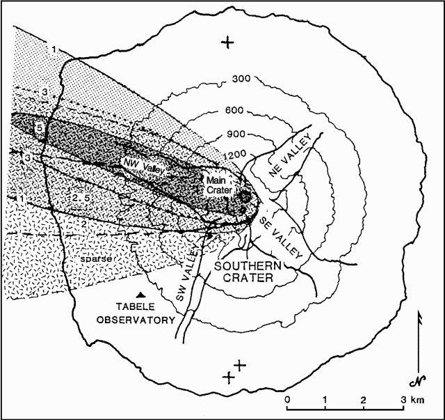 |
Figure 2. Scoria distribution (hatched pattern) and thickness (cm), and ash distribution (stippled) and thickness (mm) from Manam's 30 June 1987 eruption. Ash fell after the scoria and overlies it. Courtesy of RVO. |
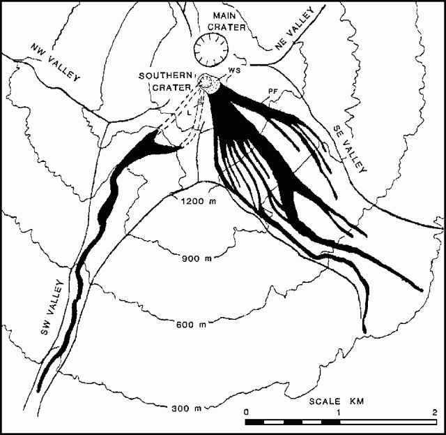 |
Figure 3. Distribution of flow products of Manam's 30 June 1987 eruption. PF = pyroclastic flow, WS = welded scoria, 1 = lava flow. Courtesy of RVO. |
Information Contacts: C. McKee, P. de Saint-Ours and P. Lowenstein, RVO.
Minor ash emission; night glow from summit
A low level of activity continued during September. Glow from Main Crater, frequently observed during the latter half of August, was observed only a few times in September. Main and Southern Craters weakly emitted white vapour. During the first half of the month, the emissions from both craters also contained small amounts of gray ash. No noises were heard during the month.
During September, the water-tube tiltmeter appeared to show an increased rate of change, after remaining fairly steady during July and August. A few microradians of inflationary tilt accumulated during the month. Seismic amplitudes remained at low levels, similar to August.
Information Contacts: J. Mori, C. McKee, and P. Lowenstein, RVO.
Increased seismicity and vapor emissions; night glow
There was a marked, though moderate increase in the level of activity at the beginning of the month. Seismic amplitudes began a progressive increase during the first week of October, when visible changes were first noticed. A weak fluctuating night glow at Southern Crater was accompanied by low rumbling and an increase in the rate of vapor emission (including blue vapour). Main Crater showed no significant change in the intensity of night glow but the amount of blue and white-gray vapor increased. Seismic amplitudes remained steady and elevated through the end of the month.
Radial tilt, which had shown a steady rise since August, showed a rapid deflation of ~3 µrad after 15 October. Deflation was continuing at the end of the month.
Information Contacts: J. Mori, D. Lolok, and P. Lowenstein, RVO.
Strombolian activity
Activity remained at the same level in November that it had reached after the moderate increase during the first weeks of October. At Southern Crater a fluctuating night glow accompanied by rumbling noises suggested that Strombolian activity was occurring within the crater. Ejections of incandescent material just over the crater rim were seen on 4 and 16 November. Main Crater emitted a moderate plume of white and blue vapor and displayed a steady night glow 12-27 November. Seismicity showed no significant change, remaining at 1,200-1,400 small-amplitude B-type events/day. Tilt measurements were steady.
Information Contacts: P. Lowenstein, RVO.
Vapor emission continues; some deflation; summit glow
Southern and Main Craters emitted small to moderate amounts of white vapour throughout December. Main Crater also emitted blue vapour on several days. Weak roaring and rumbling from Southern Crater were heard on a few days early in the month. Glow above Main Crater was observed on 8 and 27 December and was accompanied on the 27th by weak rumbling. Seismic amplitudes were stable at about twice non-eruptive levels and daily totals of volcanic earthquakes were ~1,400. Tilts were steady until 21 December when a mild deflationary phase began. About 2 µrad of deflationary tilt had accumulated by month's end.
Information Contacts: C. McKee and P. Lowenstein, RVO.
Vapor emission; rumbling; seismicity steady
Activity continued at a low level during January. Weak to moderate white vapor from Southern and Main Craters was observed. Rumbling from the summit was heard on 10, 11, and 18-20 January. Amplitudes of low-frequency earthquakes continued at the same steady level as the past 3 months. There were no significant changes in tilt.
Information Contacts: J. Mori and P. Lowenstein, RVO.
Vapor emission and glow
Activity continued at a low level during February. Weak to moderate white vapors were observed from both Southern and Main Craters throughout the month. Deep roaring sounds from the summit area (probably Southern Crater) were heard on most days. Blue vapors were released from Southern Crater on 13-14 February, and a dull, fluctuating glow was seen over Main Crater on the 14th. Amplitudes of low-frequency earthquakes continued at the same steady level as in the past 3 months. No significant tilt changes were observed.
Information Contacts: P. de Saint-Ours and C. McKee, RVO.
Tephra clouds
Activity remained at a low level during March. Weak to moderate [emissions of white] vapor from both Southern and Main Craters were observed throughout the month. Deep rumbling sounds from Southern Crater were heard on 5, 6, and 7 March (followed by a short-term rise in microseismicity), and muffled explosion sounds accompanied forceful emissions of brown ash and vapor clouds on the 28th and 31st. The heavier, more dense fragments from those emissions fell back on the sides of the summit cone. Amplitudes of low-frequency earthquakes remained at about the same level as in the previous 4 months. No significant tilt changes were observed.
Information Contacts: P. de Saint-Ours and C. McKee, RVO.
Weak incandescent lava ejection
"Activity remained at a low level during April. Both Southern and Main Craters released white vapours at weak to moderate rates. Low rumbling noises from Southern Crater were heard . . . on 13-16 and 30 April. On the 15th, weak projections of incandescent lava fragments were observed from Southern Crater. No significant tilt changes were recorded."
Information Contacts: D. Lolok, C. McKee, and B. Talai, RVO.
Minor ash and incandescent lava ejections
"Activity remained at a low level during May. Both Southern and Main Craters released white vapours at weak to moderate rates. However, emissions from Southern Crater occasionally carried ash during the second half of the month and were accompanied by thin blue vapours on the 26th and 28th. Main Crater emissions also contained ash on 4, 5, 10, 16, and 20-23 May. Low rumbling noises from Southern Crater were heard on 2-12 and 19-25 May. Weak ejections of incandescent lava fragments from Southern Crater were seen on the 3rd and 23rd. No significant tilt changes were recorded."
Information Contacts: H. Patia and P. Lowenstein, RVO.
Ash and vapor emission; rumbling noises
"Activity remained at a low level during June. Both Southern and Main Craters released white vapours at weak to moderate rates. Emissions from Southern Crater were occasionally ash-bearing and were accompanied by thin blue vapours on 3 and 10 June. Deep rumbling noises from Southern Crater were heard on 3 June and from 17 June to the month's end. No night glow was observed, and no significant tilt changes were recorded."
Information Contacts: P. de Saint-Ours and P. Lowenstein, RVO.
Ash and incandescent tephra
"Mild activity continued during July. Southern Crater emitted weak to moderate pale-grey ash and vapour clouds. Weak roaring and rumbling sounds were often heard, and incandescent lava fragments were ejected on 14 and 28 July. Main Crater commonly emitted weak-moderate white vapour that possibly contained ash during a period from 27 to 29 July when both craters released blue vapours. Tilt measurements indicated a slight radial deflation of ~0.5 µrad in July, continuing a weak deflationary trend that began in mid-October 1987. Total deflation measured at Tabele Observatory since that time is ~6 µrad."
Information Contacts: C. McKee and P. Lowenstein, RVO.
Low-moderate seismicity; vapor emission
"Both Southern and Main Craters released white [emissions] with occasional grey [ash] and blue vapours at a low-moderate rate. No subterranean noises or summit glow were observed. Seismicity was low-moderate with 800-1,150 B-type volcanic events daily and sub-continuous low-amplitude tremor recorded throughout the month. An inflationary tilt change of 1.5 µrad was recorded in August after a 1.3 µrad deflationary change recorded in July."
Information Contacts: P. Lowenstein and B. Talai, RVO.
Ash and vapor emission; weak glow
"The low level of activity that continued in September was characterized by weak to moderate white vapour emissions from the summit craters. The emissions occasionally contained small amounts of grey ash and blue vapour. Weak fluctuating glow from Main Crater was seen on the 6th and 7th and from Southern Crater on the 7th and 8th. On a few days, rumbling sounds from Southern Crater were reported. Seismicity remained at a normal inter-eruptive level with a daily average of 1100 low-frequency events. Tilt measurements were somewhat erratic and no clear trends were evident."
Information Contacts: C. McKee and P. Lowenstein, RVO.
Low-level activity continues
"Low-level activity continued in October. Weak to moderate white vapour [emissions continued] from the two summit craters. Occasional small amounts of ash were ejected from Southern Crater and blue vapour from Main Crater."
Information Contacts: D. Lolok, B. Talai, and P. Lowenstein, RVO.
Ash and vapor emission; weak glow
"Activity continued at a low level during November with weak-moderate white vapour emissions from the two summit craters. Emissions from Southern Crater frequently contained small amounts of grey ash and blue vapour. On the 29th, red glow became sub-continuous and weak incandescent projections were observed. Rumbling noises from the same crater were heard throughout the month. Seismicity remained at a normal inter-eruptive level with a daily average of 1,120 low-frequency events. Tilt measurements indicated 3 µrad of inflation over the month."
Information Contacts: I. Itikarai and P. Lowenstein, RVO.
Ash and incandescent fragments; frequent B-type events
"Activity . . . remained at a low level throughout December. Both Southern and Main Craters released white vapours at weak to moderate rates. Emissions from Southern Crater were often ash-bearing and were accompanied by thick blue vapours on the 13th. Deep rumbling noises from Southern Crater were heard 1-12, 15, and 23-27 December, accompanied by weak ejections of incandescent lava fragments on the 3rd and 4th. Weak fluctuating glow from Southern Crater was observed 1-8 and 11 December. Seismicity remained at a low to moderate level with 700-1,100 B-type volcanic events recorded daily. Sub-continuous low-amplitude tremor was also recorded throughout the month. No significant tilt changes were detected."
Information Contacts: H. Patia and P. Lowenstein, RVO.
Weak ash emission and glow
"Activity continued at a low level during January with weak to moderate emissions of white vapour. Emissions from Southern Crater were accompanied by small amounts of grey ash on the 9th, 23rd, and 24th, and blue vapour on the 18th, 19th and 24th. Deep rumbling noises from this crater were often heard and weak fluctuating glow was observed on the 8th, 30th, and 31st. Seismicity remained at a low-moderate level with 700-1,200 small B-type volcanic events recorded daily. No significant tilt change was recorded."
Information Contacts: C. McKee, H. Patia, and P. de Saint-Ours, RVO.
Tephra ejection; B-type seismicity
"Manam showed a slight increase in activity during February. Fluctuating night glows and weak ejections of pyroclasts to 40-80 m above the rim of Southern Crater were observed on the 1st-4th and 21st. Emissions from Southern Crater consisted of pale-grey ash/vapour clouds and blue vapour. Deep rumbling noises from this crater were heard during the first few days of the month and for most of its second half. Main Crater's activity was very weak, consisting of white vapour emissions. Seismicity remained at a low-moderate level with daily totals of 900-1,200 small B-type events. There were no significant tilt changes."
Information Contacts: D. Lolok and C. McKee, RVO.
Vapor emission and seismicity continue
"Activity . . . remained at a low inter-eruptive level throughout March. Both Southern and Main Craters released white vapours at weak to moderate rates. Wisps of blue vapour were also released by Crater 2 on 6-9 and 22-27 March. Weak rumbling noises were heard intermittently although no night glow, incandescent ejections, or Vulcanian explosions were reported. Seismicity remained at a normal inter-eruptive level with a daily average of 1,100-1,400 small low-frequency events superimposed on sub-continuous tremor. Tilt measurements showed no trends."
Information Contacts: P. de Saint-Ours and C. McKee, RVO.
Incandescent ejections and vapor release
"Activity remained at a low inter-eruptive level during April. Both Southern and Main Craters released white vapours at weak to moderate rates. Blue vapour was also emitted from Southern Crater on 9, 13, and 22-23 April. Weak deep rumbling sounds from Southern Crater were heard occasionally 11-30 April. The summit was obscured by clouds on most nights, but during clear conditions on the 11th, glow and weak ejections of incandescent lava fragments were observed above Southern Crater. Volcano-seismicity remained at a normal inter-eruptive level with daily earthquake totals ranging between ~700 and 1,200. Tilt measurements showed no trends."
Information Contacts: C. McKee, RVO.
Two small ashfalls; seismicity declines
"Activity . . . remained at a low level during May. Southern Crater emitted white-grey vapour and ash clouds at weak rates during the first half of the month and mostly white vapour during the second half. Blue vapours were released 15, 16, and 18 May. Weak, deep, rumbling noises were heard throughout the first half of May and on the 29th and 31st. Emissions on the 7th and 18th produced light ashfalls on the island's E side. Weak incandescent projections were seen on the 1st. Main Crater's activity consisted of occasional weak emissions of white vapour.
"Seismicity had remained at a 'normal' inter-eruptive level of ~1,100 ± 200 small events/day since August 1988. During the 2nd and 3rd weeks of May, seismicity decreased slightly to ~600 events/day. Tilt measurements showed no corresponding changes."
Information Contacts: H. Patia and C. McKee, RVO.
Fewer earthquakes; slow deflation continues
"Activity was at a very low level throughout June. Southern Crater released white to grey vapour [and ash] in weak to moderate amounts. Weak deep rumbling noises were occasionally heard. Main Crater released weak emissions of white vapour. The seismicity fluctuated at a somewhat lower level than 'normal' inter-eruptive rates, between 500 and 1,100 minor events/day. Tilt readings also fluctuated, although continuing on a slow deflationary trend since early March."
Information Contacts: P. de Saint-Ours and B. Talai, RVO.
Weak gas emission; new fissures on summit lava flow
"A low level of activity continued in July. Southern Crater gently released weak to moderate amounts of thick white [emissions] with occasional light grey and blue emissions. Weak deep rumbling sounds, occurring at intervals of 5-40 minutes, were commonly heard throughout the month. Main Crater was less active, releasing only small amounts of white vapours. Seismicity continued at low inter-eruptive levels, with 400-1,080 small discrete B-type events/day.
"An aerial inspection and ground deformation measurements were conducted between the 20th and 23rd. The interiors of the summit craters were totally obscured by the emissions. The only notable change was the presence of arcuate fissures in the 1987 lava flow at the summit's E platform. Ground deformation work involved EDM, dry tilt measurements, and re-installation of two dry tilt stations that were damaged in 1987. Results of these observations will appear in the next report."
Information Contacts: I. Itikarai and C. McKee, RVO.
Minor ash emission; summit deformation
"Activity continued at a low level in August. Emissions from Southern Crater were mostly gentle, weak to moderate, white vapours with occasional grey and brown ash clouds that drifted NW of the island. A light ashfall was recorded on the W side of the island on the 30th. Low rumbling noises were heard on the 17th and 25th. Main Crater was less active, releasing weak amounts of white vapour. Seismic activity was steady at a low inter-eruptive level, with an average of 1,000 small B-type events/day.
"EDM data obtained at Manam in July is not interpretable in terms of simple inflation/deflation events at the summit. The data indicate a NNW shift of the summit area. Compared with the previous data set (November 1987), changes of +27 and -17 ppm were measured along lines on the S and N flanks of the volcano, while a change of +5 ppm was registered on the SW flank. Tilt data from Tabele Observatory . . . during the same time interval show no significant changes."
Information Contacts: I. Itikarai and C. McKee, RVO.
Occasional minor ash emission
"There was little or no change in the (low) level of activity in September. Southern Crater emissions were mostly weak white vapours occasionally containing grey or brown ash in small quantities. Weak deep rumblings were heard at the Observatory on 20, 21, and 23 September. Main Crater released small volumes of white vapour. Seismic activity remained at a low inter-eruptive level with ~900 small B-type events recorded daily. No significant tilt changes were recorded."
Information Contacts: C. McKee, RVO.
Intermittent vapor release; decreasing seismicity
"Activity has been low and decreasing steadily since the last mild eruptive period in February. The only visible sign of activity was the intermittent release of thin plumes of white vapour from both Southern and Main Craters. Seismicity has decreased progressively since August, both in the number of events (down to <500 events/day at the end of the month) and in amplitude (now at the lowest background level since July-August 1987). The radial tiltmeter . . . has been showing a low, flat trend since July."
Information Contacts: P. de Saint-Ours and C. McKee, RVO.
Slight vapor and ash emission; minor inflation
"Activity remained at a very low level in November. Weak white vapour emissions were released from both Southern and Main Craters throughout the month. There were grey emissions on a few days from Southern Crater, and a fine ashfall on the NW side of the island on the 9th. No sounds or glow were reported. The radial tilt showed a slight rising trend."
Information Contacts: D. Lolok and P. de Saint-Ours, RVO.
Weak gas emissions; glow
"Activity remained at a low level in December. Weak emissions of white vapour occurred from both Southern and Main Craters throughout the month. A weak, dull, fluctuating glow was observed over Southern Crater on the night of the 25th. There was no significant tilt change".
Information Contacts: P. de Saint-Ours, RVO.
Weak white vapor emission from both craters; rumbling
"Activity remained at a low level in January, as it has for the last 6 months. Emissions from both Southern and Main Craters consisted mainly of weak white vapour. Rumbling noises were occasionally heard on the 2nd. There was no significant tilt change."
Information Contacts: I. Itikarai and P. de Saint-Ours, RVO.
White vapor emission from summit craters; seismicity remains low
"Activity remained at a low level in February. Emissions from both summit craters consisted of white vapours in weak to moderate amounts. Weak, deep rumbling noises from Southern Crater were heard occasionally between 18 and 24 February. There were no sightings of summit crater glow. Seismicity remained low. Daily volcanic earthquake totals ranged between 1,000 and 1,100, and amplitudes were small. A progressive inflationary tilt of ~2 µrad accumulated during February."
Information Contacts: C. McKee, RVO.
Vapor emission; seismicity remains low
"Activity remained at a low level in March. The summit was obscured for long periods (4-9 and 11-23 March), but when weather cleared, emissions of white vapour in weak to moderate amounts were observed from both craters. Seismicity remained low, with daily totals of volcanic earthquakes ranging from 900 to 1,200. No significant changes were noted in seismic amplitudes and ground deformation."
Information Contacts: I. Itikarai, P. de Saint-Ours, and C. McKee, RVO.
Vapor emission with occasional ash; radial deflation
"Activity remained at a low level. The summit craters were often obscured but when clear were seen to release white vapour in weak amounts. Occasionally, Southern Crater emissions were greyish, containing a little ash. These emissions were accompanied by weak, deep, rumbling sounds. Seismicity was low throughout the month, while the water tube tiltmeter accumulated an unusual radial deflation of 4.5 µrad."
Information Contacts: P. de Saint-Ours and C. McKee, RVO.
Ash and incandescent bombs ejected; radial deflation continues
"The water tube tiltmeter at Tabele Observatory recorded a progressive radial deflation since 10 April which amounted to 6 µrad by the end of May. In April and early May there was no visible or seismic response to this tilt trend and both summit craters released white vapour in weak to moderate amounts.
"On 14 May, grey-brown ash clouds were occasionally emitted forcefully from Southern Crater, and a fluctuating glow was seen from 2125 onward, later accompanied by incandescent projections to 120 m above the crater rim. By 2300 the seismicity had increased markedly in amplitude (2x) and remained so until month's end. In the following days, brown ash-laden clouds were intermittently ejected from Southern Crater, accompanied by deep rumbling noises, but no incandescent projections or night glow were observed."
Information Contacts: P. de Saint-Ours and C. McKee, RVO.
Intermittent ash-laden clouds and B-type earthquakes
"Activity remained at a very low level. The deflationary trend recorded since April by the Tabele Observatory water tube tiltmeter stabilized after mid-May, and seismicity was at a low though irregular level in both amplitude and number of earthquakes. From 3 to 10 June, Main Crater intermittently released ash-laden clouds, accompanied by discrete B-type earthquakes. Deep rumbling sounds were heard on 3 and 4 June. In the second half of the month only wisps of white vapour were released by this crater. Activity at Southern Crater was limited to weak emissions of white vapour throughout the month."
Information Contacts: P. de Saint-Ours and C. McKee, RVO.
Inflation resumes; seismicity fluctuates
"Activity remained at a very low level. Emissions from both summit craters were characterized by weak white vapour. After 2 months of deflation, summit inflation resumed, as indicated by ~3 µrad of radial tilting recorded by the water tube tiltmeter at Tabele Observatory during July. The daily frequency of volcanic earthquakes decreased from 1,200 to 200 during the first three weeks then increased to 1,100 at the end of the month. Seismic amplitudes showed a decrease by half between the beginning and the end of the month."
Information Contacts: H. Patia and C. McKee, RVO.
Small ash eruption follows inflation and seismic changes
"A relative build-up of activity resulted in a small ash eruption from Southern Crater on 28 August. Prior to the 28th, both craters emitted weak white vapour but on 15-17 and 20 August, Southern Crater released emissions of blue vapour, low in volume. Weak low rumbling noises were heard from Southern Crater on the 17th. From 11 August, small-amplitude harmonic tremor was recorded with occasional large B-type earthquakes occurring after the 16th. At 1300 on the 28th, Southern Crater started to forcefully expel a dark column of ash to 500-600 m above the crater, accompanied by a sub-continuous weak rumbling sound with associated strong harmonic tremor. The emission decreased in vigour after 1345 and ended by 1415. A light ashfall occurred on the SW part of the island. Interestingly, a week before the ash eruption, the daily number of microearthquakes dropped from an average of 1000 to 500, and the seismic amplitude dropped by almost half. A 'normal' level of activity returned rapidly after this short eruptive phase and both Southern and Main Craters were again releasing very weak plumes of thin white vapours with a weak blue vapour plume from Southern Crater.
"Tilt measurements at Tabele Observatory showed a definite inflationary trend since late June and had accumulated up to 6 µrad by the end of August (and thus had more than recovered the deflation of April-May; 15:4-5)."
Information Contacts: I. Itikarai and C. McKee, RVO.
Weak vapor emission; decrease in seismicity at mid-month
"Following the ash eruption from Southern Crater on 28 August, visible activity rapidly returned to 'normal'. Throughout September, Southern Crater emitted variable amounts of white and occasionally blue vapour. Rumbling noises were heard from this crater on 1 September. Main Crater produced only white vapour, usually at low emission rates. Seismicity declined at about mid-month from ~1,200 to ~500 events/day. The amplitude of these events was at the normal inter-eruptive level. There were no significant tilt changes during September."
Information Contacts: I. Itikarai and C. McKee, RVO.
Weak vapor emission; earthquakes decline
"Activity declined further in October. Both craters intermittently released very weak emissions of thin white vapour. No noises or glow were observed from either crater. The decline in daily earthquake totals . . . continued in October and by the end of the month averaged only ~150 (compared to ~1,200 during former inter-eruptive periods). The amplitude of these events also decreased to a very low level. No significant changes were observed in tilt measurements."
Information Contacts: C. McKee and I. Itikarai, RVO.
Seismicity drops sharply; gas emission
"Activity remained at a low level in November. Both craters continued to release very weak to moderate emissions of thin white vapour. Additionally, thin blue vapour emissions were observed on two occasions from Main Crater, and brown ash emissions were reported once from Southern Crater. No noises or glow were reported from either crater. The daily total of volcanic earthquakes declined further from an average of ~150 at the end of October to <30 from mid-November to the end of the month. Amplitude of these events was very low."
Information Contacts: C. McKee and I. Itikarai, RVO.
Vapor emission; weak seismicity
"Activity was at a very low level in December. Both craters released very weak and occasionally moderate emissions of mostly thin white vapour. No night glows or sounds were reported from the two craters. Seismicity remained at a very low level and no significant changes were observed in measurements from the water-tube tiltmeters.
"An aerial inspection and ground deformation surveys were conducted 7-9 November. There have been no morphological changes at the summit since the last aerial inspection (July 1989). EDM measurements indicated little change along lines radial to the summit between November 1987 and November 1990. Dry tilt results were inconsistent, with two stations showing components of inflation while the third station indicated a component of deflation."
Information Contacts: B. Talai, RVO.
Vapor emission
"The level of activity . . . has been extremely low since October 1990. Throughout January, emissions from Southern Crater were very weak and consisted of white vapour. Similar emissions from Main Crater were seen until 16 January. No sounds from the craters were reported and no night glow was seen. There have been no observations of crater glow since May 1990. Volcano seismicity consisted of only a few tens of very small low-frequency events/day. Tiltmeter measurements . . . have shown a flat trend since mid-November 1990."
Information Contacts: P. de Saint-Ours and C. McKee, RVO.
Seismicity increases slightly
"A slight increase in Manam's seismicity was noted in February, but otherwise activity remained at a very low level. Daily totals of low-frequency volcanic earthquakes rose from a few tens in January to as many as 800 in mid-February before declining to 200-300 at the end of the month. Earthquake amplitude increased slightly. The only emissions were white vapours released gently from Southern Crater. No sounds from the summit craters were reported and no night glow was seen. There were no significant changes in the trends of tiltmeter measurements."
Information Contacts: C. McKee, RVO.
Increased explosions and seismicity; slight inflation
"Activity was at a low level until early 25 March, when roaring and booming sounds from Main Crater were heard, and bright to weak pulsating glow was observed. The explosions were contained within the crater, which is several hundred meters deep.
"The stronger activity was reflected in the seismicity, with increased numbers and amplitudes of earthquakes (up to 850 events/day from an average of ~150/day for the preceding few weeks, and with amplitudes ~4x greater). Tiltmeter measurements showed a slight radial inflation of ~1-2 µrad. Southern Crater showed no response to the increased Main Crater activity and continued producing gentle white to pale-grey vapour (plus ash?) emissions."
Information Contacts: C. McKee, RVO.
Tephra emission from two craters
"The increased activity at Main Crater in late March continued until mid-April, then declined. However, Southern Crater then became more active.
"Main Crater emissions consisted of weak to moderate white-grey ash and vapour with occasional thin blue vapour from 1 to 14 April. Emission clouds reached heights of 180-1,000 m above the crater rim. Light ashfall was noted 5 km downwind on 4 April. Deep roaring noises were heard on most days during this period. Weak red glow was seen above the crater 1-11 April, with some incandescent lava ejections on the 4th.
"Southern Crater activity increased for the first time since August 1990. From about mid-April, emissions consisted of weak to moderate white-grey vapour and ash. Light ashfalls were reported 23 and 25 April on the E side of the volcano, ~5 km from the summit. Low rumbling noises associated with the vapour and ash emissions were heard on 16 and 23-25 April.
"The seismograph at Manam became inoperable from 8 April. Before this time, seismic amplitudes remained at about the same level as at the end of March (~3x normal levels), although the daily totals of recorded volcanic shocks dropped from ~550 to 100. Tiltmeter measurements showed a slight radial deflation of ~1.5 µrad."
Information Contacts: C. McKee, RVO.
Ash ejection declines to weak vapor emission
". . . Manam has returned to the low non-erupting pattern displayed since early 1989. Both Main and Southern Craters released thin white vapour emissions. Grey ash-laden clouds commonly rose over Southern Crater until 20 May, associated with weak rumbling noises, presumably due to rockfalls within that crater. No night glow was reported from either crater. Tiltmeter measurements showed a slight radial inflation of ~1 µrad."
Information Contacts: D. Lolok and P. de Saint-Ours, RVO.
Occasional ash emissions
"Both craters released weak emissions of white vapour. However, some greyish, ash-laden clouds were also occasionally emitted. Between 5 and 9 June, deep roaring sounds were heard from Southern Crater and plumes of ash occasionally rose to 150-700 m above the crater rims. Similar activity recurred between 25 and 29 June. Although no night glow was observed, the seismicity was at a moderately high level and radial tilt measurements fluctuated by 3 µrad."
Information Contacts: P. de Saint-Ours, RVO.
Stronger ash emission
"Activity . . . increased slightly in July, as shown by more voluminous vapour and ash emissions, stronger sounds, and the resumption of night glow over Main Crater. Emissions from Main Crater consisted of weak to moderate white-grey ash and vapour accompanied by thin blue vapour from 22 to 25 July. Occasional deep roaring noises were heard on the 4th-6th. A weak fluctuating night glow was visible 23-25 July for the first time since April. Southern Crater emitted thin to thick grey-brown ash clouds, occasionally rising to ~400-500 m above the crater rim. Booming and deep roaring noises were heard on most days throughout the month, but no night glow was observed. Seismicity was at a moderate level and tiltmeter measurements showed no change."
Information Contacts: C. McKee, RVO.
Occasional ash emission; lava dome
"Main Crater produced weak emissions of white vapour with low ash content on 1, 2, and 3 August. Blue vapour was visible on 8, 11, and 12 August and only white vapour during the last week of the month. There were no audible noises and no night glow was seen.
"The emissions from Southern Crater consisted of tenuous white vapour with occasional grey-brown ash clouds resulting in fine ashfalls on parts of the island. Occasional weak deep roaring and rumbling noises were heard 2-14 August and a weak red glow was observed around the crater mouth on the night of 7 August. An aerial inspection was carried out on 13 August. Southern Crater was partly filled with vapour but Main Crater was clear. The floor of Main Crater was occupied by a solid plug or mound of lava, at a level ~20 m below the lower (NE) part of the crater rim. White mofettes were released by numerous fumaroles around the base and lower walls of the crater. The crater floor was mostly covered by debris from the crater walls, but in the central area, the lava plug was visible over an area ~5 m in diameter, and consisted of steaming lava surrounded by small blocks and scoriae ejected during a stronger degassing phase. During the aerial inspection, emissions from Southern Crater were low-energy, thermally buoyant clouds, released fairly regularly at ~15-minute intervals.
"Seismicity was at a moderate level and tilt measurements showed a deflation of ~1.5 µrad since mid-August."
Information Contacts: B. Talai, C. McKee, and P. de Saint-Ours, RVO.
Weak ash emission continues but incandescent tephra ejection stops; little deformation
Low levels of activity persisted in September-November, with weak white vapor emissions from Main Crater, and occasional gray ash emissions from Southern Crater. Incandescent tephra rose to ~50 m above the rim on 12 September, and to 80-120 m height on 17, 19, 21, and 23 October. No night glow was observed in November. Occasional weak rumbling noises were heard during October, and on 14, 20, and 24-25 November. Fine ashfall was reported on parts of the island on 18, 23-24, and 26-28 October; less-intense ash emissions occurred during the first half of September and the second half of November. Seismic activity remained at moderate levels, decreasing slightly in September, with small increases noted in mid-October and 10-12 November.
"A survey of Manam was carried out on 12 November. Changes along the EDM lines radial to the 1,750-m-high cone since the last survey (November 1990) were inconclusive, but could be interpreted as reflecting a slight deflation of the N flank (i.e. around Main Crater, the activity of which has markedly declined since a short period of stronger activity there in March-April 1991) and a slight inflation of the SW flank (i.e. around the mildly active Southern Crater). Dry-tilt stations are apparently too low on the flanks of the volcano to record significant changes. Overall, these ground deformation results reflect the low level of intermittent activity at the volcano over the last few years."
Information Contacts: B. Talai and C. McKee, RVO.
Ash emission; incandescent lava fragments roll down flank valley
"Activity . . . remained at a low level. Main Crater was inactive throughout December except for a very weak emission of white vapour on the 23rd. Southern Crater activity consisted mostly of weak white vapour emissions. A forceful ejection produced a thick, dark ash cloud that rose several hundred meters above the summit on 5 December from 1105 to 1120, accompanied by intermittent roaring and rumbling noises. Incandescent lava fragments were observed rolling down the SW valley, and there was light ashfall on the NW and SW sides of the island. Light ashfalls also occurred on 20 and 26 December. No night glow was visible above the summit during the month. The seismograph was not operational."
Information Contacts: D. Lolok and B. Talai, RVO.
Ash ejection; incandescent tephra
"There was a slight increase in activity at Manam's Southern Crater during mid-January. Bad weather conditions prevented observation of the summit until 11 January. Southern Crater emitted thin to thick grey and brown ash clouds on 12-21 and 30 January. The emissions resulted in fine ashfall on the SE side of the island and were accompanied by occasional weak roaring and rumbling noises. For the first time since mid-October 1991, weak fluctuating glow and projection of incandescent lava fragments (to 80-120 m above the crater rim) were seen on 30 January. Some of the incandescent lava fragments rolled down the SE valley. Activity from Main Crater remained at a very low level throughout January, consisting of gentle emissions of thin white vapor. Seismic recording resumed on 23 January, ending 2 1/2 months of instrumental problems. Seismic activity was at a low-moderate level with daily counts of low-frequency events ranging from 100 to 500."
Information Contacts: H. Patia, P. de Saint-Ours, and B. Talai, RVO.
Ash emission; seismicity remains low
"Activity at Manam's Southern Crater was at a low-moderate level during February with a slight increase at the end of the month. Southern Crater emissions consisted of weak pale-grey or pale-brown vapour and ash clouds. On a few days the ash content of the emissions was markedly higher, leading to ashfalls in coastal areas (4-5 km from the summit). In general, the emissions occurred without significant sound effects, although rumbling was heard on 29 February in association with thick, dark ash clouds, night glow, and incandescent lava ejections. No activity was observed from Main Crater. Seismicity fluctuated a little but remained at a low level with daily counts of low-frequency events ranging from 100 to 350."
Information Contacts: C. McKee, RVO.
Vigorous Strombolian activity, strongest since 1987; small debris flows
"A build-up of activity at Southern Crater led to a series of brief phases of moderate-strong Strombolian activity starting on 23 March. Weak Strombolian eruptive activity started at Southern Crater on the evening of 29 February. Incandescent lava ejections were weak to moderate (up to 200 m above the crater), and intermittent (every few minutes or up to 6/minute) throughout the first 20 days of March. During the day, incandescence was not seen, but each burst produced a "puff" of brown ash-laden vapour that rose to between 500 and 1,000 m above the crater and produced fine ashfalls in coastal areas downwind. The ash consisted of ~45% black lithic material, 35% oxidized fragments, apparently from older rocks, and ~20% fresh-looking glass shards and crystals.
"The seismicity was at a moderate level, with 400-1,100 small, low-frequency events per day. Starting on 21 March, a definite build-up in seismicity (1,200-1,400 events/day of larger amplitude) was recorded in association with more forceful ash-laden ejections. Incandescent lava fragments rose to 500 m above the crater. The seismicity became sub-continuous in the afternoon of 23 March, moderately strong explosion sounds started to rattle the walls of Tabele Observatory . . . , and dark grey-brown ash clouds rose forcefully to 900-1,000 m above the crater. From 1615 to 2000 this crater produced sub-continuous emissions of incandescent scoriae to ~1,100 m above the crater rim, with flashing arcs a few seconds apart accompanying each explosion. Scoria avalanches descended into the upper SE and SW valleys, and ash and lapilli fell into coastal areas. The lapilli were as large as 3 cm in size and consisted of light, highly vesiculated, grey glassy pumices with ~5% crystals. The maximum thickness of the lapilli-ash deposit was ~0.5 cm. At the end of this eruptive phase, the seismicity dropped dramatically, but resumed six hours later when another similar phase of activity (of lesser intensity) started and continued for ~30 minutes.
"During the following week, a new pattern of activity was observed. Periods of sub-continuous Strombolian eruptions, with low frequency events in such close succession as to look like monochromatic tremor of fluctuating amplitude (lasting about an hour each) were separated by periods of irregular duration (0.5-22.75 hours) during which no emissions or night glow were seen over the crater and virtually no seismicity was recorded. Altogether there were 24 periods of sub-continuous Strombolian activity (counted from the periods of seismicity that characteristically accompanied them) between 23 and 30 March. Some of these active phases were followed by periods of intermittent, mild Strombolian activity lasting a few hours. After 30 March, the more usual pattern of regular Strombolian activity and seismicity (1,300-1,400 small events/day) resumed."
The crew of Qantas flight 59 reported a moderately dense black plume rising . . . to ~2.5 km altitude on 1 April at 1417. A NOTAM was issued several hours later. The observer at Manam reported sub-continuous ejection of thick gray-brown ash clouds to 400-500 m above the summit on 1 April, consistent with the aircraft report. Seismograms that day showed an even distribution of small volcanic earthquakes, not indicative of strong Strombolian activity.
"Aerial and ground inspections were conducted between 28 and 30 March. Southern Crater, which since at least 1975 has had an open funnel shape with a diameter of ~50 m, was bowl-shaped, clogged with agglutinated scoriae, and the active vent was only ~15 m wide and 8 m deep. There was no emission from the crater area between eruptions. The summit area was mantled with scoriae, but these deposits did not extend in any significant thickness lower than about the 1,000-m level, and no lava flows were produced. Only one small debris flow deposit was recognized in the SE valley; the flow descended a gully along its southern margin. Although the nose of the flow stopped at 950 m elev, a lighter hot cloud overriding it apparently continued to ~900 m elev, scorching vegetation. Other small debris flows may have contributed to the apron of pyroclastic debris on the upper part of the SE valley. A few small debris flows would have, similarly, cascaded down the steep rock face at the head of the SW valley and come to a stop in its amphitheatre, at ~900 m elev.
"Throughout March (and since April 1991), Main Crater was totally inactive, and its floor covered with debris eroded from the crater walls. Tilt recordings showed no significant change throughout the month, although 3 µrad of radial inflation were recorded at Tabele in the 3.5 months preceding the onset of the eruption. In late March, two short leveling lines (~500 m long) were laid out radially to the volcano on the lower E and NW flanks for further ground deformation monitoring in the upcoming months.
"The previous most significant activity from Manam occurred in June 1987. On 30 June, after a period of ~1.5 months of mild Strombolian activity, an intense Strombolian eruptive phase (of similar character to the latest activity) produced numerous scoria flows into the SE and SW valleys down to ~300 m elev. This phase also produced a short viscous basaltic lava flow, lapilli, and ashfalls that caused some damage to subsistence gardening areas near the coast (between 4 and 5 km radial distance from the crater). In comparison, the latest eruption was of lesser magnitude. It produced less than half the amount of material (<2-5 x 10⁶ m3) and no significant damage to gardens or inhabited areas."
Information Contacts: I. Itikarai, P. de Saint-Ours, and C. McKee, RVO; ICAO.
Strong explosions; scoria flows; first lava flow from Main Crater since 1960
"The eruption continued strongly in April with new paroxysmal phases of activity at Southern Crater and activation of Main Crater, which emitted a lava flow for the first time since 1960. The intensity of the eruption was declining in late March and early April, and activity at this time was restricted to Southern Crater. The moderate Strombolian activity there consisted of ash emissions that were rising to ~1 km over the crater at the beginning of April, but by 8 April were only rising a few hundred meters. On 8 April, Strombolian activity began at Main Crater, which became active for the first time in the eruption. The ash content of emissions was low. Ejections of incandescent lava fragments were visible at night, rising 100-200 m above the crater.
"Seismicity began to increase on 9 April as sub-continuous, irregular tremor became progressively stronger. This coincided with stronger explosive activity at both craters as ash clouds rose ~1 km and sound effects were more prominent. This buildup culminated in a paroxysmal phase of activity at Southern Crater starting about 0300 on 11 April. For about 2 hours, there were nearly continuous strong explosions at Southern Crater, projecting incandescent lava fragments to ~1 km above the rim. Ash clouds rose considerably higher. This activity seems to have been significantly stronger than the previous paroxysmal phase on 23 March. Scoria flows were directed into both the SE and SW valleys, although the SE valley was the main pathway. The flow deposits extended ~3.5 km down the SE valley to a point ~270 m asl. The volume of the flow deposits is estimated to be ~100,000 m3.
Coarse tephra were confined to a stream channel on the S side of the valley but the overriding ash clouds left thin deposits of fine ash in relatively narrow zones (up to 100 m wide) bordering the coarse flow deposits. Vegetation damage ranged from scorching to complete destruction. Scorching was evident to the top of the SE Valley's S wall (100-200 m above the floor). The bulk of scoria-flow deposits in the SW valley are within ~500 m of the base of its near-vertical headwall. A more surprising product of this phase of activity was a lava flow in the SW valley, which is detached from its source at Southern Crater. The lava flow disintegrated as it descended the steep headwall of the SW valley. A prominent channel near the center of the headwall was scoured out by the cascade of lava. On reaching the base of the headwall, the lava flow was reconstituted. The ribbon-like body of lava that now fills the main drainage channel in the upper part of the SW Valley is ~900 m long. Its width ranges from ~20 to 40 m, and its thickness is ~10 m. From these dimensions, the volume of the lava flow is estimated to be ~300,000 m3.
"There was a decline in Southern Crater activity after the paroxysmal phase, although ash emissions were reported to have risen ~2 km over the vent during 11 and 12 April. Southern Crater activity ceased sometime overnight on 12-13 April, and the focus of activity shifted to Main Crater, where bright fluctuating glow was reported the same night. On 13 April, the first reports of a lava flow from Main Crater were received. Lava was flowing into the NE valley for the first time since 1960, following a stream channel on the valley's N side. On 16 April, the terminus of the flow was ~2 km from the source, at ~600 m above sea level. The source of the flow was a breach in the flank of an ejecta cone that infilled a large portion of the previously deep, funnel-shaped Main Crater. Daylight incandescence was visible in the lava flow for ~800 m from the source and at several points farther downslope. With the advent of lava effusion from Main Crater, seismicity rose to its highest level of the eruption. Seismicity remained high until 30 April when lava effusion ceased temporarily. Throughout this period (13-30 April) explosive activity at Main Crater was mild. Frequent ejections lofted incandescent lava fragments 100-200 m, and ash clouds ascended to 500-1,000 m above the crater. The content of ash in the emissions was low. The explosive activity at Main Crater was continuing at the end of April, while Southern Crater remained inactive."
Information Contacts: C. McKee, RVO.
Strong explosions from summit craters; lava flows; avalanches
"The eruption continued strongly in May with new paroxysmal phases of activity at Southern Crater on 10, 14, 16, 23, and 31 May. Main Crater was active 2-7 May, 14-16 May, and 26 May through the end of the month. New lava flows were emitted into the NE valley during these periods. Unlike former episodes of strong eruptive activity (i.e. 1974, 1984), the current episode involves both summit craters, in an intermittent pattern. Following a period of strong, lava-producing activity from Main Crater in April, Southern Crater was reactivated on 2 May. This crater had been blocked by sluggish lava and/or rubble from its last paroxysmal phase (11 April), and was re-opened after several loud explosions and ejection of dark, ash-laden columns with incandescent blocks up to 980 m high. On 3 May, and for a few days after, activity at Southern Crater consisted of intermittent explosions producing debris avalanches that were channelled into the upper SW valley. Main Crater became the center of activity again on 4 May. At approximately 1100, it started to produce a strong, sustained ash column that rose 1,000-3,000 m above the summit, deep roaring sounds, and an increase in the level of seismicity. At night, a bright glow and incandescent projections (to 125 m) were visible from Tabele Observatory . . . , but an aerial inspection on 5 May revealed that a new lava flow was being emitted from a fissure on the flank of the dark scoria cone now occupying Main Crater, at ~1,600 m elev. The lava flow overrode earlier flows emitted in April down to ~500 m elev, then followed a stream channel on the S side of the valley. Summit activity waned on 6 May and the flow stopped on 7 May, at ~60 m elevation, after advancing 4.5 km.
"On the following day (8 May), the level of activity increased in Southern Crater with Strombolian projections up to 300 m above the crater rim. At 1415 on 9 May, a second vent became active. Both vents then displayed sub-continuous Strombolian projections up to 100 m (N vent) and 500 m (Iabu vent), while the level of seismicity, which consisted of a succession of low-frequency events and microtremor, increased. This activity culminated in a paroxysmal phase on the night of 9-10 May. At 0040, a deep roaring sound was heard. This became louder and was followed by the outrush of incandescent lava fragments up to 1,000 m above the crater. During the following hours, the high output rate of lava spatter was maintained, accompanied by very loud explosion sounds that shook walls and windows at the Observatory . . . . Concurrently, lightning-and-thunder effects were occurring in the 3,000-m-high vapor-and-tephra cloud generated by the eruption and by the pyroclastic avalanches into both the SE and SW valleys. A lava flow poured out of Iabu vent, tumbled into the SW valley, and progressed down to 600 m elev during the following day.
"Seismicity and eruptive activity were low for the three following days but another paroxysmal phase of activity occurred in the early morning of 14 May. From 0200, weak roaring and explosion sounds were heard and Strombolian projections (50-125 m above the crater rim) resumed from the N vent of Southern Crater, while seismicity steadily built. Between 0430 and 0700, continuous incandescent projections were reaching heights of 500 m (Iabu vent) to 1,100 m (N vent), with spatter falling back as far as the foot of the terminal cone. A lava flow from Iabu vent tumbled into the SW valley. Even after the Strombolian activity stopped at the summit, the lava flow continued throughout the day and the following night, progressing down the valley to 200 m elev, a total length of 3.8 km. After 0700 on 14 May, emissions from Southern Crater had changed to produce a silent ash column that died out at about 0900. In the afternoon, explosions related to deep Strombolian activity in Main Crater were observed at ~10/minute, and at night the incandescent projections were seen rising to 400 m above the crater rim. By the morning of 15 May, Main Crater was emitting a silent, thick, billowy column of grey ash that lasted until 16 May. In the afternoon of 16 May, Southern Crater entered yet another paroxysmal phase, similar to the one on 14 May. This time only Iabu vent was active, displaying a glowing ribbon of new lava flowing into the SW valley, to an estimated 400 m elev. Strombolian activity died out around 2030 on 16 May, as did the lava flow the next afternoon.
"After a few uneventful days with only white and blue vapours released from multiple cracks around the craters, the eruption resumed from Southern Crater on 20 May. This time a new vent on the W side of the crater was active. Until 23 May, it produced weak, intermittent, ash-laden explosions, with nighttime incandescent projections up to 180-250 m above the crater. The seismicity built up from 0300 on 23 May. By 1130, after a marked increase in activity over 30 minutes, Southern Crater entered yet another phase of intense Strombolian eruption that lasted until 1430. This was followed by discontinuous Strombolian eruptions until late afternoon. A new lava flow from Iabu vent progressed into the SW valley to an estimated 600 m elevation. There was weak fluctuating activity in Southern Crater for another week, during which Main Crater was reactivated, producing weak to strong Strombolian eruptions with variable amounts of ash. Another paroxysmal phase of activity occurred at Southern Crater on 31 May, between 1330 and 1700. It produced a thick, dark-grey cloud and was accompanied by continuous roaring sounds and another lava flow into the SW valley.
"Water-tube tilt measurements at Tabele Observatory first showed a 2 µrad radial deflation, then a steady recovery throughout the month. Other dry tilt and levelling lines around the island were checked repeatedly but showed no significant change.
"The intermittent, recurring activity in the two craters has the effect of markedly modifying their configuration between each aerial reconnaissance. Following the ash eruption in mid-May, the scoria and spatter cone that initially occupied Main Crater was changed into a somma-type feature, with a 50-m-wide vertical crater in the center. Likewise, repeated emissions of lava flows into the SW and NE valleys are significantly modifying their topography; the volumes of erupted material are being calculated. Each eruptive phase also produced a few mm to cm of ash and lapilli falls onto coastal areas on the NW and SE sides of the island. These deposits are not yet significant enough to dangerously affect villages and subsistence gardens."
Information Contacts: P. de Saint-Ours and C. McKee, RVO.
Strong ash ejections; Strombolian explosions; lava and pyroclastic flows
"The eruption . . . ended on 15 June after another paroxysmal phase from Main Crater (on 7 June). Following the paroxysmal phase of 31 May from Southern Crater, the level of activity was moderate in the first days of June. Both craters were emitting white and blue vapours in weak to moderate amounts, with occasional explosions of ash-laden vapour rising a few hundred meters above the craters, weak roaring noises, and weak fluctuating glow at night.
"On the afternoon of 5 June, Southern Crater entered a phase of intermittent Strombolian activity that sprayed incandescent spatter to as much as 300 m above the crater at intervals of 30-40 minutes. At 1600, Main Crater emitted a dark ash column to ~1,000 m above the crater. Strombolian explosions within the crater must have started soon afterwards, as suggested by fluctuating night glow and roaring sounds. On the 6th, the level of activity remained moderate at Southern Crater while it strengthened at Main Crater. The forceful emissions of grey-brown ash from the latter were identified as Strombolian projections at night. From 0025 until about 1830 on 7 June, this crater produced continuous incandescent projections to 600 m above the rim in an ash column that rose 2-3 km. New lava flows were erupted into the NE Valley and followed the path of the previous flows (4-6 May) on the southern side of the valley, down to 110 m asl.
"Pyroclastic flows were also produced, scorching vegetation and some garden areas on the southern side of the NE Valley to about 1 km from Bokure Village. Downwind from the crater, on the NW side of the island, the sustained dark ash cloud overhead, the fall of ash and lapilli, and roaring sounds of the eruption caused some concern to the population.
"This paroxysmal eruption phase ended with loud explosions from 1817 to 1830 on 7 June. In the following days there was hardly any visible activity from either crater, apart from weak-to-moderate vapour emission. However, the seismicity, which had increased dramatically during the eruptive phase of 6-7 June, remained moderately high. On 12 June, occasional dull explosion sounds were heard again from Main Crater with occasional brown ash clouds and incandescent projections at night. This activity lasted until the 14th, becoming more and more intermittent. The last significant event from Main Crater observed in this eruption was a moderately strong Vulcanian explosion at 0800 on 14 June, which projected a convoluting cloud to 2-3 km above the crater. Likewise, Southern Crater was somewhat reactivated 13-15 June, with occasional weak explosions, a fluctuating night glow, and incandescent projections to 250 m above the crater rim. From 16 June onward, the seismicity dropped markedly and neither crater showed further signs of activity apart from weak, fumarolic emission. The Stage 2 volcanic alert that had applied since 13 April was dropped to Stage 1 (i.e. non-threatening, background level) on 25 June.
"This eruption of Manam is among the most significant since 1958, and can be compared with the eruption of 1974 (Palfreyman and Cooke, 1976; Cooke et al., 1976) as it involved both craters, produced pyroclastic flows and lava flows of significant volume, and affected all but one of the main valleys. However, the 1992 eruption appears to have been larger than the 1974 event. A preliminary estimate of the 1992 lava-flow volume is 17 x 106 m3, compared with only 3 x 10⁶ m3 of lava flows in 1974."
References. Cooke, R.J.S., McKee, C.O., Dent, V.F., and Wallace, D.A., 1976, Striking Sequence of Volcanic Eruptions in the Bismarck Volcanic Arc, Papua New Guinea, in 1972-75; in Johnson, R.W, ed., Volcanism in Australasia, Elsevier, p. 149-172.
Palfreyman, W.D. and Cooke, R.J.S., 1976, Eruptive History of Manam Volcano, Papua New Guinea; Ibid., p. 117-131.
Information Contacts: P. de Saint-Ours, D. Lolok, and C. McKee, RVO.
Weak ash emission and glow
"Activity during July remained at the low levels reported for the second half of June. There was weak fumarolic activity through most of July, with white and blue vapours emitted from Southern Crater and mostly white vapours from Main Crater. Weak grey ash from Southern Crater was observed on 22 July.
Weak fluctuating night glow from Southern Crater was seen 20-29 July, due to deep-seated explosive activity. There was no night glow from Main Crater during the month and no audible sounds from either crater. Seismic activity was at a low level throughout July. A slight increase was noted later in the month, probably related to the incandescence and explosive activity. No significant change has been recorded from the water-tube tiltmeter at the Observatory since the beginning of May."
Information Contacts: B. Talai and C. McKee, RVO.
Strong explosions; lava flow; pyroclastic flow reaches the sea
"Strong eruptive activity resumed at Manam after a 2-month quiet period. Following the March-June eruption, activity in both craters was very subdued, consisting only of weak fumaroles, a faint night glow, and low-level seismicity.
"From 10 August, however, mild, deep-seated eruptive activity resumed in Southern Crater, with weak white and blue vapour emissions, weak roaring sounds, and a fluctuating night glow. Seismicity remained at a moderately low level, but a definite inflation trend was recorded by the water-tube tiltmeter . . . (+2 µrad in three weeks).
"On 21 August, activity increased with forceful degassing and incandescent Strombolian projections over Southern Crater. By 29-30 August, dark ash-laden vapour emissions were released intermittently and nighttime incandescent projections were reaching 700 m above the crater.
"This activity culminated in a paroxysmal phase on 31 August. The microseismicity increased in intensity from mid-morning. Unfortunately, cloudy weather hampered observations, but starting from 1650, forceful continuous eruption of incandescent material took place and lasted for ~6 hours. A dark column of basaltic pumice and ash rose to ~5,000 m above the summit of the volcano, and produced heavy lapilli/scoriae and ashfall over the WNW side of the island until about 1930. Concurrently, lava emitted by Southern Crater started to flow into the SW valley, cascading down the headwall. At about 1700 a large pyroclastic flow ran down the same valley. At ~600 m asl it overflowed the narrow valley-channel and progressed down to the sea with a width of ~120 m. Another pyroclastic flow ran down the SE valley, along the southern bank, but stopped at ~500 m asl.
"The high level of eruptive activity (with strong red glow observed through the cloud cover) lasted until 2300. The next day, the mountain was still cloud-covered. The level of seismicity and noise had decreased but the lava flow was still active.
"Field inspection on 4-6 September revealed that the pyroclastic-flow deposits in the SW valley were still hot, consisted of scoriae, boulders, and tree trunks, and were 6 m thick at the coast. The flow had devastated vegetation and gardens along the way, but fortunately had not hit two neighbouring coastal villages. The coastal road was cut off. The lava flow had overridden the pyroclastic flow deposits but had stopped at ~700 m asl. The flow front was ~70 m wide and 5 m high. The pyroclastic-flow deposit in the SE valley consisted mainly of scoriae. Southern Crater was breached to the south. Lapilli and ashfall on the W and NW flanks of the volcano had severely damaged subsistence gardens. The largest scoria at Tabele Observatory was 12 cm.
"Interestingly, this paroxysmal phase occurred a couple of days after the radial tilt had reversed, from a rising to a rapidly deflating trend. The tilt has now (early September) lost all the inflation accumulated earlier; seismicity has dropped to a relatively low level, and visible activity in Southern Crater is limited to weak white-grey emissions, intermittent deep explosion sounds and a weak night glow. Main Crater has remained inactive since mid-June."
Information Contacts: P. de Saint-Ours and C. McKee, RVO.
Strong explosions; pyroclastic and lava flows
"Manam continued erupting in September, with a paroxysmal phase of activity from Main Crater at mid-month. Following the paroxysmal eruption from Southern Crater on 31 August (BGVN 17:08), its activity subsided to a low level in early September. Emissions consisted of white and blue vapours at low to moderate rates.
"Southern Crater emissions changed on 13 September to forceful emissions of thick dark-grey ash clouds and incandescent lava fragments. This activity continued on 14 September, then subsided, and there was a return to emission of white and blue vapours. The stronger visible activity was accompanied by a rise in seismicity.
"Main Crater, which had been inactive since mid-June, began to show signs of re-awakening on 11 September when forceful emissions of thick white vapour clouds were observed. On 15 September, bright glow was observed over Main Crater, and at 0500 on 16 September, above the atmospheric cloud-cover, a high eruption column was seen, indicating that a paroxsymal eruption was in progress. The ash column rose several kilometers above the crater before being blown to the NW. Reports from inhabitants on the N side of the island indicate generation of small pyroclastic flows followed later by lava extrusion into the NE valley. The new lava covered a substantial portion of the April-June lava flows and reached to within 2 km of the coast (figure 4). At night on 16 September, weak-to-bright glow was observed, punctuated by intermittent projection of incandescent lava fragments to 50 m above the crater. Lava effusion ceased by 17 September.
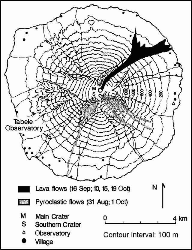 |
Figure 4. Topographic sketch map of Manam Island, showing pyroclastic and lava flows through October 1992, villages, and observatory sites. Courtesy of RVO. |
"A somewhat weaker phase of activity from Main Crater took place on 20 September, starting at about 1845 and ending at about 2130. Seismic activity showed a corresponding increase during this period. Dense, dark, ash clouds were released and rose several kilometers above the crater. Incandescent lava fragments within the eruption column reached 500-700 m above the crater, but most fell into the crater. For the remainder of the month, Main Crater activity was moderate, with emissions of thick white vapour and occasional grey ash clouds. Weak glow above the crater continued to be observed until the end of the month. Light ashfalls took place intermittently on the W flank throughout the month.
"Seismicity continued to consist of low-frequency events and sub-continuous tremor. Over the course of the month seismicity showed a number of fluctuations but the general trend was one of increased amplitude. Measurements from water-tube tiltmeters . . . showed a 4 µrad deflation to mid-September following the paroxysmal eruption of 31 August. By the end of September the volcano had re-inflated by 1 µrad.
"Further eruptive activity took place in October. During a paroxysmal eruption from Southern Crater on 1 October, pyroclastic flows descended the SW and SE valleys and moderate-to-heavy scoria-fall took place on the W side of the island. The pyroclastic flows were contained within the valleys and did not cause any damage. The scoria-fall reportedly damaged some food gardens. On 10 October, voluminous lava effusion from Main Crater resulted in lava flowing into the sea at two points in the NE Valley. Another phase of strong lava effusion occurred on 15 October. Part of the lava flow overwhelmed three houses in a village near the edge of the NE valley and entered the sea.
"Yet another effusive phase from Main Crater was reported on 19 October. The volume of lava erupted may have been smaller than the amounts erupted on 10 and 15 October. The emplacement of pyroclastic flows and lava flows in the main valleys at Manam has clearly demonstrated the high hazard potential of these parts of the volcano. Recommendations have been made for the evacuation of settlements near the SW and NE valleys. It is not anticipated that the entire population (6,000 residents) of Manam will need to be evacuated."
Information Contacts: B. Talai and C. McKee, RVO.
Strong explosions feed 10-km column; lava and pyroclastic flows; 18 buildings destroyed
"Manam continued to erupt during October, with a paroxysmal phase of activity from Southern Crater at the beginning of the month and a series of strong effusive phases from Main Crater in the middle of the month. "Activity had increased at Southern Crater at the end of September (29th and 30th). Continuous bright-red glow and projections of incandescent lava fragments were accompanied by moderate-to-dense emissions of white (occasionally blue) vapour, frequent rumbling, and occasional explosion noises. This culminated in a paroxysmal eruption on 1 October, which produced an ash column rising ~10 km above the crater. Pyroclastic flows descended SW and SE Valleys, but were contained in them and did not cause any property damage (figure 4). The flows in SW Valley advanced ~4 km from the crater while those in SE Valley traveled ~3.5 km. Moderate-heavy scoria fall on the W side of the island reportedly damaged some food gardens. A new lava flow in SW Valley advanced ~1.6 km from the crater. After the eruption, activity at Southern Crater declined, with weak-to-moderate emissions of white and occasional blue vapour throughout the month.
"Main Crater was more active in October with weak-to-moderate emissions of white vapour, accompanied occasionally by forceful projections of dark-grey ash rising a few hundred meters above the crater. On the night of the 9th, projections of brightly incandescent lava fragments were observed. At about 0400 on the 10th, very bright continuous glow was seen above the summit, quickly followed by lava extrusion into NE Valley. The lava was channeled into four low-lying gullies and reached the sea in two places.
"There was no night glow for two days after the eruption, and only small-to-moderate amounts of white vapour were emitted. An aerial inspection showed a deep funnel-shaped vent in Main Crater. Main Crater activity subsequently intensified and emissions changed to thick white vapour and frequent expulsions of dense grey ash clouds rising several hundred meters above the summit crater. "On 14 October, a brief period of more intense activity took place. Commencing at 0445, the activity consisted of frequent rumbling and explosion noises, red incandescent lava-fragment projections, and forceful emissions of dense grey ash clouds at a rate of ~3/minute. The visible activity was accompanied by a rise in seismicity. Most of the eruptive activity stopped at about 1530. An aerial inspection of the summit showed that projections of incandescent material were continuing, but the vent was choked with debris.
"About 0600 on the 15th, Main Crater activity intensified again. The rate of explosions of lava fragments and ash was ~5/minute. At 0830, the red incandescent projections became continuous, reaching ~100 m above the crater. Two small pyroclastic flows seen around this time traveled only a few hundred meters downslope from the vent. At 1015 lava was extruded into NE Valley. The lava flow overwhelmed 3 houses in a village near the S edge of the valley and entered the sea along a wider flow-front than on 10 October. Lava effusion stopped at about 1245. The eruptive column reached ~6 km above the crater during this period.
"Between 16 and 18 October, the summit was covered in atmospheric clouds so no observations were possible. No noises were heard, but the seismograph showed that seismic activity was high.
"When the summit cleared early on 19 October, a weak glow was seen from Main Crater, which brightened as time progressed. No incandescent projections were observed. Intermittent, low rumbling noises were heard from 0450 onward. There appeared to be a slow build-up of an eruption column during the morning. The summit was obscured after 0650. Inhabitants on the N side of the island reported a pyroclastic flow in NE Valley at about 0920. This advanced ~3 km from the summit, stopping 200 m short of a village. Lava extrusion followed, with a large volume of lava (although probably smaller than on 10 and 15 October) channeled into the S half of the valley, reaching within 60 m of the coast. Effusive activity stopped in the early afternoon.
"Following this eruption, the level of activity declined and remained low until the 25th, when explosions began to intensify again. There was an increase in seismicity and in visible activity, with emissions of dense dark-grey ash clouds, rumbling noises, and bright-red glow at night.
"A total of 14 houses and four cocoa fermentaries, all constructed from bush materials, were destroyed by the lava flows in October. The emplacement of pyroclastic flows and lava flows in the main valleys at Manam has clearly demonstrated the high hazard-potential of these parts of the volcano. Recommendations have been made for the evacuation of settlements near SW and NE Valleys. It is not anticipated that the entire population of Manam will need to be evacuated.
"Measurements from the water-tube tiltmeter . . . showed 1.5 µrad of inflation up to 8 October, and 4 µrad of deflation following the paroxysmal eruption on the 10th. Inflation was recorded from the 23rd until the end of the month.
"Figure 5 shows seismic signal amplitudes for September and October. The eruptions on 16 September and 1 and 10 October were preceded by gradual increases in seismicity, over periods of 4-10 days. The 15 October eruption took place during a period of high seismicity, whereas the eruption of 19 October occurred during a decline in seismic activity."
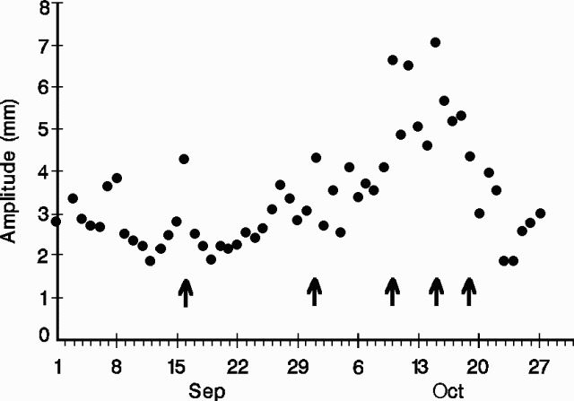 |
Figure 5. Seismic-signal amplitudes recorded at Manam, September-October 1992. The amplitudes are daily means based on the mean amplitudes of the five largest events each hour. Arrows mark the five strongest eruptive episodes. Courtesy of RVO. |
Information Contacts: I. Itikarai, R. Stewart, and C. McKee, RVO.
Strong explosions; pyroclastic flows; lava flows to sea
"Manam continued erupting during November, with a paroxysmal phase from Main Crater on the 5th-6th. Towards the end of October and in early November, Main Crater's emission column showed a progressive reduction in size from several kilometres to <1 km. On 3 and 4 November, white to pale-grey emissions with very low ash contents were seen. In inverse correlation with the reduction in eruption column size, seismic activity showed a steady increase.
"The increasing seismicity heralded a new phase of strong activity at Main Crater. A rapid intensification of Main Crater activity began about 1800 on 5 November, with strong emission of thick ash clouds. The ash column reportedly rose to ~7 km. Moderate-heavy ash and scoria fall occurred on the downwind (W) flank of Manam. Small pyroclastic flows were generated early in this phase, descending the NE valley and terminating 2-3 km from the coast. A lava flow succeeded the pyroclastic flows and reached the coast (5 km distance) at about midnight (figure 6). The lava advanced through part of a village on the S side of NE Valley, obliterating 14 houses and a number of food gardens. This lava flow was reportedly the fastest-moving of all of the flows produced during Manam's 1992 eruption. It had stopped moving at the coast by about 0300 on 6 November. There seems to have been a complex interplay between lava effusion and the generation of pyroclastic flows, as parts of the lava flow were overridden by pyroclastic flows produced during and after the effusive phase. These pyroclastic flows were unlike earlier ones in that they contained significant amounts of accessory lithics. Some of these blocks are as much as 8 m across. One very large block moved down the valley, leaving a trail of striations. A portion of this lithic material could have been vent-derived, but there is clear evidence that some of it was eroded from the lava flows flanking the crater.
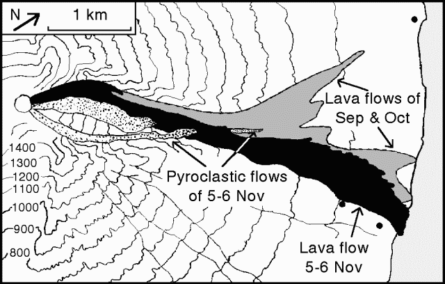 |
Figure 6. Sketch map of the September-October 1992 lava flows at Manam, and the lava flow and pyroclastic-flow desposits of 5-6 November in NE Valley, all from Main Crater. The NW Valley deposits, Southern Crater, and its deposits in SW and SE Valleys are not shown. Note that north is to the upper right. Courtesy of RVO. |
"A second pulse of strong explosive activity from Main Crater took place early on 6 November. This activity was somewhat unusual in that it generated pyroclastic flows which, for the first time in this eruption, were directed over the high back-wall of the crater into the NW valley. These are the first pyroclastic flows to be emplaced in NW Valley since the very strong eruption of 1958. Unlike the flows erupted into NE Valley on 5 November, the NW Valley flows consisted almost entirely of vesiculated juvenile material. These flows were as much as 60 m wide and 5 m thick. At one point, ~550 m asl, where a flow had bifurcated into two parallel drainages, thin surge deposits (~10 cm total thickness) were found along the separating ridge. Where the main body of the flow had cascaded down a dry waterfall in the main drainage channel, arcuate pressure ridges had been formed. The terminus of the NW Valley pyroclastic-flow deposits is ~320 m asl, ~3.5 km from the summit.
"The strong eruptive phase had ended by about 0600 on 6 November. Seismic activity showed a good correlation with visible activity, peaking late at night on 5 November, then showing a subsidiary peak at about 0200 on 6 November. Seismic activity had reached a low level by 0800 on the 6th. Ash was still being emitted from Main Crater, however, and formed a column ~1 km high at 0900. Southern Crater was not involved in this activity and continued to gently release small amounts of white vapour.
"There were no additional strong eruptive phases at Main Crater through the remainder of the month. Ash and vapour continued to be emitted, forming a column up to ~1 km high for most of this period, although rarely the column was as much as 2 km high. Light ashfalls were reported in coastal areas downwind. Weak-to-bright glow from both craters was seen on most nights and small ejections of incandescent lava fragments were occasionally observed. At Southern Crater the emissions consisted of white and blue vapours in small-to-moderate volumes.
"Seismic activity following the eruption of 5-6 November was at a low level until the 14th, when it again began to increase. Seismicity stabilized at a moderate level on the 18th, then began declining on the 25th. At the end of the month, seismicity was stable at a low level.
"Aerial inspections of the summit showed that Main Crater is a shallow funnel-shaped structure with a high wall on its W side. Numerous fumaroles are present in the partial somma around the S side of the vent. Southern Crater is a smaller structure than Main Crater - topographic details were mostly obscured by emissions."
Information Contacts: C. McKee, RVO.
Activity declines after 4 months of vigorous eruption
"Activity . . . during December declined to a low level, after four months of eruptive activity. Emissions from Main Crater on 1-8, 20, and 28 December consisted of moderate-to-thick vapour with light ash content rising 500-1000 m above the summit. Light ashfalls were reported in coastal areas on the NE and SE sides of the island. Occasional weak-to-loud roaring noises were heard, only during the first half of the month. Activity at Southern Crater was similar to that in November, with emissions of white and blue vapours in small-to-moderate volumes. Weak-to-bright night glow from both summit craters was visible until 18 December. From the 19th until the end of the month, both summit craters were covered by atmospheric clouds.
"The decrease in seismic activity that began in mid-November stabilized at a low level at the beginning of December, and continued throughout the month. Radial tilt measurements showed a 3-µrad deflation during the last two weeks of the month after being stable since 11 November."
Information Contacts: H. Patia and B. Talai, RVO.
Activity remains low; weak vapor emissions
"Low level activity continued at S Crater. Emissions consisted of weak vapour, occasionally with light ash content. Weak fluctuating glow was seen above the crater every night of January after the 5th. Main Crater released a thin to moderately thick plume of white vapour. Seismicity consisted of discontinuous low-amplitude tremor and low-frequency events of small amplitude throughout the month. Tiltmeter measurements showed no trends."
Information Contacts: R. Stewart, P. de Saint-Ours, and C. McKee, RVO.
Weak emissions; discontinuous low-amplitude tremor
"Low-level activity continued at Manam's S crater. Emissions consisted of weak white vapour, with occasional light ash content. A weak, fluctuating glow was seen above the crater whenever atmospheric conditions allowed. The main crater released only whisps of white vapour. Seismicity throughout the month consisted of discontinuous low-amplitude tremor and low-frequency events of small amplitude. Tiltmeter measurements showed no trends."
Information Contacts: R. Stewart, P. de Saint-Ours, and C. McKee, RVO.
Activity continues at very low level
"Activity . . . continued at a very low level throughout March. During the month's first and last weeks, when the summit area was clear, emissions from both craters consisted of thin white vapours being released at a weak-to-moderate rate. No night glow was reported. There was a report of acid rainfall 12 March on the upper slopes SE of the summit. Seismicity throughout March consisted of discontinuous low-amplitude tremor and small low-frequency events. Tilt measurements showed no trends."
Information Contacts: H. Patia, R. Stewart, and C. McKee, RVO.
Very low activity
"Activity . . . continued at the very low level reported in March. Emissions from both summit craters consisted of weak-to-moderate white vapour. No night glow was reported. Seismic activity was low throughout April and the tilt measurements showed no trends."
Information Contacts: N. Lauer, R. Stewart, and C. McKee, RVO.
Weak ash emissions resume
"A low level of activity resumed in May after 3 months of inactivity. Starting on 11 May, Southern Crater released emissions, occasionally forceful, of white-grey, ash-laden clouds that rose 200-800 m above the summit crater and produced light ashfalls on the SE side of the island. Emissions were occasionally accompanied by weak deep rumbling noises. A weak, fluctuating glow was observed 31 May."
Information Contacts: I. Itikarai, P. de Saint-Ours, R. Stewart, and C. McKee, RVO.
Ash emissions increase; moderate eruption in mid-July
". . . Manam became more active in June. Southern Crater released occasionally forceful emissions of white-dark grey, ash-laden clouds rising 1-2 km above the summit crater until 15 June, when activity declined slightly. Occasional roaring and rumbling noises accompanied the emissions. Fluctuating crater glow and projections of incandescent fragments, ascending to as much as 125 m above the crater rim, were observed until 18 June. Main crater continued weak emissions of white vapour; no noise or glow was reported. The seismograph remained unoperational in June. Tilt measurements showed no significant changes."
A pilot report described an intermittent, very dense, dark gray plume . . . on 14 July that rose above 10 km altitude before being blown W; a lava flow was also noted. Australian radio reported on 16 July that an alert had been issued to residents on the N coast of Manam Island after an eruption of the volcano. Ash was reported to have fallen on the W and S parts of the island, with lava flows observed in the southern valleys.
Information Contacts: D. Lolok and C. McKee, RVO; ICAO; Melbourne Radio Australia.
Moderate eruption produces ashfall, pyroclastic flows, and lava flows
"Activity reached a high level in mid-July with a paroxysmal eruption on 14 July from Southern Crater. Activity was then low through the end of the month.
"From 1 to 4 July, both Main and Southern craters released occasional small emissions of mostly white vapours with no audible sounds or night glow. Mild, deep-seated eruptive activity began at Southern Crater on 5 July with occasional forceful emissions of white-grey, ash-laden clouds rising several hundred meters above the summit, accompanied by sub-continuous weak-to-loud roaring and rumbling noises. Rapid degassing started on 7 July with incandescent Strombolian projections up to ~100 m above the summit and rocks cascading down the headwall into SW Valley. This level of activity continued until 11 July, and then declined slightly.
"Activity at Southern Crater intensified at 1200 on 14 July as a new eruptive phase began with continuous strong emission of dark ash-laden clouds. The basaltic scoria-and-ash column reportedly rose to about 11 km and was accompanied by continuous loud roaring sounds. Moderate-heavy ash and scoria fall occurred from 1300 to 2000 on the W flank. Heavy tephra fall caused several hours of partial darkness on the W side of the volcano. The maximum measured ash-fall thickness of 80 mm was recorded between the coastal villages of Yacca and Kuluguma (5 km NW), damaging vegetation and food gardens. No casualties were reported. About 2 mm of ashfall occurred on the mainland at Awar Plantation (20 km W) and Watam village (30 km NW). Ashfall was detected as far as 90 km NW of the volcano. Weather satellite imagery indicated that the emission plume was oriented SW from the volcano and was ~170 km long at 1630 on 14 July.
"Small pyroclastic flows, generated at 1300, descended into SW Valley and stopped 3 km from the coast. At about 1820, moderate-to-large pyroclastic flows in SE Valley stripped and burned vegetation from the upper banks of the valley and along its course before reaching the sea, 5 km from the summit. Lava flows followed the pyroclastic flows into SE and SW Valleys. The largest of the lava flows was in SW Valley, and was ~2.5 km long, 40 m wide, and 3-4 m thick, terminating 3 km from the coast. The level of activity at Southern Crater declined on 15 July and stayed at a low level until the end of the month. Activity consisted of the release of white and blue vapour in small amounts with no audible noises or night glow.
"Main Crater activity remained low throughout the month with the emission of mostly white vapour in small-to-moderate volumes on 6, 16, and 31 July, while moderate volumes of white-grey ash and vapours were released between 7 and 15 July. The seismograph was not operational during most of July. Measurements from water-tube tiltmeters during 1993 have fluctuated over a range of a few microradians, although there may be a slight inflationary trend. The 14 July eruption appears to have had little or no effect on the tilt measurements."
Information Contacts: B. Talai, R. Stewart, and C. McKee, RVO.
Ash emissions weak but steady; moderate eruption in early August
"Manam's activity continued at a low and steady level in August and September. Weak white vapour emissions took place at Southern Crater throughout August and September with occasional weak ash emission in September. More forceful activity occurred on 6-7 August with occasional explosions producing ash-laden clouds. Main Crater activity during August and September consisted of weak white vapour emissions. Seismicity in August included several hundred low-frequency events/day which produced sub-continuous tremor on 6, 7, 20, and 29 August. In September, Manam's seismicity was steady until about the 24th, then declined with seismic amplitudes dropping by ~50%. Tilt measurements in September . . . oscillated over a range of ~1.5 µrad, reaching maximum inflation at mid-month."
Information Contacts: C. McKee, N. Lauer, L. Sipison, B. Talai, R. Stewart, and D. Lolok, RVO.
Short but strong eruption in early October
"A short but strong eruption occurred from Southern Crater on 3-6 October. Starting at about 0700 on 3 October grey ash emissions were released at 3-5 minute intervals with rumbling and booming sounds. Strong fluctuating crater glow and incandescent lava ejections accompanied the explosions after 1830. By 1700 the next day ash emission had become forceful, leading to 5 hours of sub-continuous out-rush of incandescent material starting at 2200. Pyroclastic flows were emplaced in the SE valley, together with a short-lived lava flow that stopped at 150 m elev (from 1,750 m) giving it a length of ~4 km. Scoria avalanches descended the steep headwall of the SW valley. Ash and scoriae fell on the upper slopes of the volcano, with only 10 mm of ashfall in villages on the NW coast of the island (5 km away). The eruption waned through 5-7 October, with only weak white and blue vapour, glow and incandescent ejections, and occasional ash laden emissions. After 8 October, only silent weak white and blue emissions were reported. There was little or no premonitory warning of the eruption; the low seismicity of recent months showed little change, and the water tube tiltmeter at Tabele Observatory . . . recorded no significant changes."
Information Contacts: C. McKee, P. de Saint-Ours, and I. Itikarai, RVO.
Moderate eruptive activity from both craters
". . . activity from both craters remained at a low to moderate level in November. Emissions from Southern Crater consisted of weak white vapour throughout the month with thin blue vapour on most days during the latter part of the month. Weak red crater glow was observed on 14, 15, 16, 25, and 26 November. Weak roaring noises accompanied the glow on the 16th and 25th. Incandescent lava ejections accompanied by weak detonations rose to ~80 m above the crater rim on 22 November. On the 29th the vapour emissions became continuous and activity intensified into Strombolian explosions reaching heights of 500-800 m above the crater rim. Similar activity was observed on the 30th. Light ashfalls were recorded on the SW side of the volcano. There were no significant changes recorded by the water tube tiltmeter . . . ."
Information Contacts: I. Itikarai and C. McKee, RVO.
Explosions and gas emissions increase in late December
"Following several days of mild Strombolian explosions at Southern Crater in late November, activity returned to weak emission of white vapour and minor blue vapour. This low activity persisted until 23 December when emissions became more voluminous. The next day, rumbling and roaring sounds from the crater were heard, and weak ejections of incandescent lava fragments were observed at night. Explosions were heard over the next few days and the emission cloud became grey or brown as the ash content increased. Crater glow or weak incandescent lava fragment ejections were seen on a few more nights near the end of the month.
"Seismicity increased slightly in accord with the visible activity at Southern Crater. Main Crater remained quiet throughout December, releasing small volumes of white vapour at low rates. Water-tube tiltmeter measurements . . . showed a deflationary trend through December, with an accumulated tilt of ~1 µrad."
Information Contacts: C. McKee and R. Stewart, RVO.
Short-lived eruption sends ash cloud to 8 km altitude and lava down SE flank
"A brief eruption occurred from Southern Crater on 5 January. The intensity was similar to the stronger phases of activity in the prolonged eruption of 1992 and to the brief episodes in July and October 1993. An increase in activity started on 3 January with occasional deep roaring sounds accompanying thin grey emissions and night-time incandescent lava projections as high as 150 m. On 4 January, emissions were of moderate volume and incandescent projections reached 400 m. Simultaneously, there was a progressive increase in seismicity (amplitude, number of events, and tremor).
"The peak of the eruption occurred during the night of 5-6 January, with strong incandescent projections to ~1 km (estimated in cloudy weather conditions), and ash much higher. The pilot of an aircraft passing over the volcano at about 0230 on the 6th reported a lava flow in SE Valley. Another pilot, at 0815, estimated that the ash cloud was rising to 4-8 km asl and drifting SW. Scoria and ash fell on the SSW flank of the volcano. Seismicity during that night reached 9x the usual inter-eruptive background level.
"Lava effusion into SE Valley was voluminous, and the foot of the flow almost reached the coast, ~ 5 km from the summit crater. A small pyroclastic flow descended into SW Valley, but stopped at 750 m elev, ~1 km from the source. The volume of ash emission, and the seismicity, decreased from 6-8 January. Although a weak night glow prevailed for the remainder of the month, emissions from Southern Crater were reduced to weak white vapour release.
"Paradoxically, the eruption occurred after two months of steady deflationary tilting (-3 µrad at the observatory . . .). The eruption itself caused an additional 3 µrad of deflation, but rapid recovery took place throughout the remainder of January. Main Crater activity was unaffected throughout the month, consisting of gentle release of small volumes of white vapour."
A volcanic ash advisory was issued to aircraft following pilot reports on 6 January of ash clouds drifting SW and lava flows. The Bureau of Meteorology in Darwin, Australia, was unable to detect any ash clouds on satellite imagery.
Information Contacts: D. Lolok and P. de Saint-Ours, RVO; BOM, Darwin.
Weak white vapor emission
"A low level of activity prevailed at Main and Southern craters in February. Both craters exhibited continuous gentle white vapour emissions. No sounds were reported. Low-intensity night glow from Southern Crater was reported on 10 February. Seismic activity showed a slight increase to moderate levels during the first week of the month, then remained steady throughout February. Tilt measurements during the first half of the month showed no changes. Deflation of -1.5 µrad (radial) was observed 16-19 February. No tilt changes were observed after the 19th."
Information Contacts: B. Talai and C. McKee, RVO.
Weak ash emission from Southern Crater
"Low-level activity prevailed at Main and Southern Craters. Both craters gently emitted weak white vapour. A small ash emission from Southern Crater on 8 March was accompanied by roaring sounds and steady weak glow. This activity had ceased by 10 March. Seismic activity was at a moderate level throughout the month, although there was a steady, but small, increase starting at the time of the ash emission. Measurements from water-tube tiltmeters . . . showed slight deflation."
Information Contacts: B. Talai and C. McKee, RVO.
Weak white vapor emissions
"The level of activity remained low during April. Throughout the month both craters released only emissions of weak white vapour. Seismic recording was restricted to the period 4-13 April because of battery problems. The level of seismicity appeared to be slightly higher than in March, but still within the range of normal background levels. No significant changes in ground deformation were indicated by measurements from the water-tube tiltmeters."
Information Contacts: I. Itikarai, and C. McKee, RVO.
Weak to moderate vapor emissions, low seismicity, no tilt
During May, activity . . . remained low. Crater emissions consisted of thin white vapor released at weak to moderate rates. Throughout the month seismic activity remained at low to moderate inter-eruptive levels. Tilt, measured in the water-tube tiltmeter . . . , remained stable.
Information Contacts: I. Itikarai, and C. McKee, RVO.
Low rates of vapor emission and seismicity; steady inflation
"Activity remained at a low level during June. Both craters continued to emit thin white vapour at low to moderate rates. Seismic activity fluctuated, but remained at low-to-moderate inter-eruptive levels (200-1,400 events/day) throughout the month. Steady inflationary tilt has been recorded since February at a rate of ~0.5 µrad/month."
Information Contacts: D. Lolok, R. Stewart, I. Itikarai, P. de Saint-Ours, and C. McKee, RVO.
Explosions on 5-7 July generate ash clouds and eject lava fragments
"During July, there was a brief increase in the level of activity from Southern Crater, while Main Crater activity continued to remain at a low level. Activity from Southern Crater was low from 1 to 4 July with gentle emissions of small volumes of white vapour. From 1430 on 5 July onwards, activity increased as weak deep-sounding explosions were heard at 5-10 minute intervals accompanying forceful emissions of grey-brown ash clouds. Incandescent lava fragments were seen being ejected from Southern Crater during the evening until the activity stopped at 2130. Ash emissions continued to occur until 7 July, and only one explosion was heard on 6 July. For the remainder of the month, activity at Southern Crater continued at the normal low level, with only white vapour emissions and blue vapour observed on 12 and 15 July.
"Throughout the month Main Crater continued to emit white vapour, weak to moderate in volume. A whitish-grey plume was seen on 31 July. No sounds were heard and no night glow was observed.
"Seismic activity remained at a low-moderate level throughout the month, with small fluctuations in the number and amplitude of low-frequency earthquakes. On average ~1,170 earthquakes/day were recorded, and there was a brief quiet period from 25 to 27 July when <500 earthquakes/day were recorded. There were no significant tilt changes in July.
Information Contacts: B. Talai, R. Stewart, and C. McKee, RVO.
Ash ejections from Southern Crater up to 1,000 m above the summit
"Increased activity at Southern Crater began on 8 August following a week of low-level activity. This change initiated with weak emissions of thick grey ash clouds. On the 9th, the emissions changed to forceful ejections of thick grey-brown ash clouds that caused light ashfall on the NW side of the volcano. Activity subsided after the 11th, but started again on the 18th and continued until 30 August. The thick grey-brown ash columns rose ~400-1,000 m above the summit. Most of the ash ejections were associated with explosion and low roaring and/or rumbling noises. Incandescent lava fragment projections were seen on 23 and 26-30 August.
"Activity from Main Crater consisted of emissions of weak-to-moderate white vapour through August. No noises or night glows were observed. Seismicity remained at low levels throughout the month except for a brief period during 21-29 August when it was moderate. This coincided with the period of thick brown ash cloud emissions and incandescent lava fragment projections. On average, ~1,200 volcanic earthquakes were recorded each day."
Information Contacts: I. Itikarai, R. Stewart, and C. McKee, RVO.
Intermittent activity followed by a mid-October eruption with lava flow
"Following intermittent periods of minor eruptive activity during the previous months, activity at S Crater was low during the first week of September. Weak white-pale grey emissions returned, accompanied by occasional roaring sounds and low-level seismicity (~1,000 small long-period events/day, with a scaled amplitude of 7-10 mm). Periods of stronger activity occurred on 8-11, 14-20, 22, and 29 September.
"Starting at 1845 on 8 September, a loud explosion accompanied a period of incandescent projections to 150 m above the crater, followed by the sounds of blocks tumbling into the radial valleys. For the next three days, grey ash-laden clouds were intermittently ejected above the crater, with weak glow and incandescent projections at night. The eruptive sequence ended with one hour of loud explosions and incandescent projections to 500 m above the crater on the 11th. This was accompanied by a marked rise in seismic amplitude (up to 16 mm), but little change in the event rate (950-1,300/day).
"From 14-20 September, S Crater emitted ash-laden vapour up to 600 m above the crater, and there was light ashfall on the NW flank and on coastal villages. It was accompanied by weak-loud roaring sounds and a moderate level of seismicity (~850-1,200 events/day, with amplitudes of 12-14 mm). When this active phase ended on the 20th, the amplitude of the background seismicity rose markedly to ~15 mm. With the outbreak of the next eruptive phase, the amplitude decreased but the daily event count rose to ~1,500.
"Very thin white and blue vapour is all that was emitted by S Crater on 21 September, but from then onwards, large dark ash clouds were rising at 10-20-minute intervals, to 800-1,000 m above the crater. No sound or night glow was visible for the first few days. On the 26th, the ash column reached 2,000 m above the crater and weak incandescent projections were seen throughout the night, reaching ~200 m above the crater at intervals of 1-2 hours. This level of activity, with a background seismicity of 1,400 events/day of moderate amplitude (11-13 mm), lasted until the 28th. The dark emissions became continuous on the 29th but then died out progressively.
"South Crater was mildly active in early October. Weak to moderate emissions of white and grey vapour were released at intervals of 10-20 minutes, resulting in light ashfall downwind. A weak glow and incandescent projections were visible on the nights of 2-3 and 7 October. Throughout this time the seismicity was at a moderately low eruptive level of 1,300-1,500 events/day of 10-14 mm maximum amplitude. The water-tube tiltmeter at Tabele Observatory showed no trend.
"Starting on 14 October, seismicity increased to 15 mm maximum amplitude and Strombolian explosions occurred at intervals of 2-15 minutes, with roaring and explosion sounds. On the 16th, seismicity rose to 1,640 events of 16 mm maximum amplitude, accompanying Strombolian projections 125-320 m above the crater. Through the 17th, the moderately strong and loud Strombolian activity became sub-continuous. Ballistic blocks cascaded down the headwall of SW Valley and into the upper SE Valley. After 1500, a forceful column of ash was rising 6-10 km above the vent. At nightfall, continuous incandescent projections reached 1,100-2,000 m above the crater. The strength of the eruption seemed to increase after midnight until daybreak, with explosions rattling the walls of the . . . observatory. Seismicity peaked-up simultaneously with innumerable events of relative maximum amplitude of 130 mm. A lava flow poured out at a very high rate through a breach on the E side of S Crater and followed the N wall of the SE valley.
"Activity declined during the 18th. The ash column was still rising 4-6 km, with moderately strong roaring sounds and explosions, and the amplitude of earthquakes was still up to 30 mm. The eruption gradually waned after 1630. In the evening, explosions were 2-4 minutes apart, accompanied by weak incandescent projections. The lava flow entered the sea sometime during the night. On the 19th, S Crater had only weak-to-moderate, less forceful emission and seismicity had dropped to non-eruptive levels (~1,000 events/day of 10 mm maximum amplitude). Interestingly, there was no response of the tiltmeter to this eruption.
"Aerial and field inspections on the 18th (R. Middleton) and 19-20th (B. Talai) revealed an absence of pyroclastic-flow deposits, which is unusual for an eruption of this intensity at Manam. The lava flow was of aa-type, <50 m wide up-slope and bounded by levees. It broadened when reaching the base of the terminal cone, between 800 and 600 m elev. It reached a maximum width of ~300 m at 260 m elev where the main front stopped, and a thickness of 3-5 m. The smaller lobe that progressed to the sea following a dry creek on the N side of the valley had a flow front ~100 m wide and 4-5 m high. It extended the coast out by 10-15 m, but had stopped flowing by the 19th. The only damage was to the forest and a copra dryer.
"In the SW valley, effects were limited to a large build-up of talus at the foot of the rock face, down to ~900 m elevation. On the NW side of the island, downwind ash deposits were limited to ~3 mm of fine grey ash with scattered scoria fragments of <1 cm, in a fan area only ~1 km wide. After a 3-day period of inactivity and through the rest of October, weak white and blue vapour emission and weak glow at night recurred.
"All through September, activity at Main Crater consisted of weak, thin to moderately thick emissions of white vapour, without noise or night glow, as in the previous months. There was, somewhat surprisingly, no significant change in the trend and fluctuations of tilt measurements. Activity in Main Crater also remained undisturbed during October, as it released only occasional thin white vapour."
Information Contacts: C. McKee and P. de Saint-Ours, RVO.
Two short eruptions: one produces a lava flow, the other, pyroclastic flows
"During November, the background level of activity consisted of noiseless weak emissions of white and blue vapour, with weak glow at night. Two short eruptions occurred at South Crater in November. A lava flow was produced on 12-13 November and pyroclastic flows on the 28th.
"On the evening of the 10th, weak incandescent projections were seen just above the crater rim. Nothing could be seen on the 11th, although weak rumbling noises were heard. On the morning of the 12th, white-grey, ash-laden emissions were rising 600-700 m every 3-5 minutes. By night time, moderately strong Strombolian explosions accompanied a forceful dark-brown ash column rising 1-2 km above the crater, with loud rumbling and explosion sounds. Glowing lava fragments rolled down into the SE and SW valleys, and thick ashfall was reported in coastal areas on the ESE side of the island. Lava started to flow out of South Crater into the SE valley at 1900 on 12 November and the flow later stopped with the front at ~700 m elev. The strength of the eruption decreased after 0200 on the 13th, and for the next day and a half, the crater produced high, loud, bright explosions at progressively longer time intervals (from 1-15 minutes apart).
"Weak rumbling sounds and fluctuating glow were reported on the 25th. Intermittent (3-5 minute intervals) forceful emissions of dark ash-laden vapour, accompanied by weak-to-loud rumbling or explosion sounds, were noted on the 26th at 1730. Emissions became sub-continuous by 1900. A period of sub-Plinian activity with high projections of incandescent fragments lasted until the next morning. During 27-28 November, forceful dark emissions occurred at 1-2 minute intervals. The strength of the eruption seemed to increase again after 1030 on the 28th and there were pyroclastic flows in the SE valley at 1330. The eruption waned after ~0400 on the 29th, becoming intermittent, with forceful grey-brown explosions to 1-2 km above the crater and glowing lava fragments to 100-200 m. Unstable products around the vent tumbled into the SE and SW valleys as scoria avalanches.
"Main Crater activity was apparently unaffected by these eruptions. It continued to release white vapour in weak to moderate volumes throughout November. The water-tube tiltmeter at Tabele Observatory showed no significant deflection. No seismograph was operating."
Information Contacts: B. Talai, R. Stewart, and P. de Saint-Ours, RVO.
Eruptive activity at South Crater ends in mid-December
"The intermittent eruptive activity . . . continued until mid-December. There was no eruptive activity during the second half of the month. Main Crater continued to release weak to moderate volumes of white vapour throughout December. The water-tube tiltmeter at Tabele Observatory showed no significant changes during December. No seismograph was operational.
"On 1 December, emissions from South Crater were initially of ash-laden vapour, but changed to dark grey ash after 1250. The ash columns rose 500 m above the crater and produced fine ashfall to the ESE. The emissions were accompanied by weak roaring and rumbling noises at intervals of 5-10 minutes. Lava fragments were heard cascading down the SE and SW valleys and were seen at night as incandescent ejecta. There were further weak rumbling noises on 2 December and weak steady glow until the 4th. On 6 and 7 December there were occasional roaring noises and a small ash column was seen on December 6 with fine ashfall on the ESE side of the volcano. From 11 to 13 December, weak roaring and rumbling noises were again heard at 5-10 minute intervals with occasional booming and explosion noises. Dark grey ash emissions again accompanied this activity, the strongest of these (12 December) rising 600 m above the crater. On the night of 11 December, weak incandescent projections accompanied the explosions, rising 100 m above the crater. There was no eruptive activity from 15 December until the end of the month and emissions were mainly of weak white vapour. Weak glow was seen on all nights when the summit was visible. Occasional weak roaring sounds were heard on 30 and 31 December."
Information Contacts: D. Lolok, R. Stewart, and B. Talai, RVO.
Weak vapor emissions and crater glow
"The non-eruptive activity at Southern Crater that began during the second half of December continued throughout January. Emissions consisted of white vapour being released at low-moderate volumes, accompanied by thin blue vapour. Weak night glow was visible throughout the month when the summit was clear. Main Crater continued to release weak-to-moderate volumes of white vapour. No significant change was shown by the water-tube tiltmeter . . . . The seismograph was not operational during January.
Information Contacts: H. Patia, R. Stewart, and B. Talai, RVO.
Activity continues to decrease; weak vapor emissions
"Activity during February decreased further from January levels. Both South and Main craters released weak white vapours in low to moderate volumes. One explosion from South Crater on 19 February emitted a grey cloud, and a weak glow was seen on the night of the 24th. Seismicity was low during the first half of February, but increased somewhat during the 2nd and 3rd weeks. No significant change was shown by the water-tube tiltmeter 4 km SW of the summit."
Information Contacts: P. de Saint-Ours, R. Stewart, and B. Talai, RVO.
Gentle vapor emissions, weak glow, and low-level seismicity
"South Crater released occasional gentle emissions of thin-to-thick white vapour during most of the month, but from 28-31 March the amount of vapour emissions decreased. Thin wispy blue vapour emissions were observed on the 31st. Weak steady glow was observed occasionally (on 3, 22-24, and 26-28 March). There were no audible sounds produced. Main Crater also released occasional gentle, thin-to-thick white vapour emissions. There were no night glows and no audible sounds. Seismicity fluctuated but was at a low level during most of the month. A decline in seismic activity occurred on 26 March and persisted for the remainder of the month."
Information Contacts: B. Talai, RVO.
Both seismicity and tilt low; gently steaming
Although activity at Manam remained low in April, throughout the month both Main and Southern Craters infrequently discharged white vapor. Southern Crater discharged wispy blue vapor on the 11th; faint rumbling sounds were heard on one occasion only (at 2330 on 23 April); weak night glow was seen mainly during the 2nd and 4th weeks of April, when then summit was clearly visible. Main Crater issued occasional, thin to thick white vapors. These emissions were gentle and were not accompanied by night glow or audible sounds. The seismicity fluctuated at a low level throughout the month. No significant change was shown by the water-tube tiltmeter located about 4 km SW from the summit.
Information Contacts: David Lolok and Ben Talai, RVO.
Increased vapor emissions, red glow, and rumbling noises
"During the first half of May, S Crater was quiet and gently released white vapour in small to moderate volumes. Summit glow was observed on the 4th only. During the second half of the month, the rate of white vapour emissions was generally the same, but small to large volumes of blue vapour were gently released as well. The blue vapour emissions were seen on 15, 18-20, 23-24, 27, and 29 May. Steady weak red glow was observed on 17-19, 25, and 28-31 May. Weak rumbling noises were heard on 15, 17-18, 22, and 25 May. Main Crater emissions consisted of white vapour released gently in small to moderate volumes. No noise was heard and no crater glow was seen. Seismicity showed a marginal increase during the second half of the month, reflecting changes in the observed visual activity for the same period. The water-tube tiltmeters showed 1.5 µrad of radial deflation."
Information Contacts: Ima Itikarai and Ben Talai, RVO.
Minor vapor emissions and crater glow
"Visibility at Manam was very poor during most of June due to atmospheric cloud cover. When it was clear, white vapors, weak to moderate in volume, were seen released from both Southern Crater and Main Crater. A small quantity of blue vapor was released from Southern Crater on 11 June. There were no audible sounds from either crater. Weak summit glow was observed over Southern Crater on 2 and 3 June. A small decrease in low frequency seismic events occurred on 18 June with a declining trend during the second half of the month."
Information Contacts: Ima Itikarai and Ben Talai, RVO.
Low to moderate degassing; no deformation
During August, Manam's summit craters were covered with atmospheric clouds, but when visible, they were simply emitting white vapor at low-to-moderate rates. There were no audible sounds from either crater and no sightings of crater glow. Tiltmeters (installed 4 km SW of the summit) registered little or no ground deformation.
Information Contacts: Patrice de Saint-Ours and Ben Talai, RVO.
Passive degassing
Activity was low during October. During the month, both summit craters released only white vapors at low to moderate rates and both audible sounds and summit-crater night glow were absent. During the first three weeks of October, the daily totals of low-frequency earthquakes were at 200-500, but by month's end they increased to 800-1,300. Coincident with the increase, earthquake amplitudes also rose by ~50%. No visual changes accompanied the increase in seismicity. However, data from tiltmeters (4 km SW of the summit) showed a deflation of approximately 1.5 m µrad beginning around the second half of the month.
Information Contacts: Ben Talai, RVO.
Steam release with occasional minor ash and bombs
Throughout November, Manam's activity remained low and night glow from its craters was absent. On 8 December, weak projections of incandescent lava were seen, and steady glow took place on the nights of 9 and 10 December. During November and December, both summit craters chiefly released steam, but on 8, 17, and 19 November South Crater released wisps of blue vapor, and on 25 and 28 November it released gray ash. South Crater also made weak, low-frequency roaring sounds on 1 November. Except for 6-11 December, activity was low during most of the month.
Earthquakes increased at the end of October, but during November they took place at the moderate rate of 600-1,400/day. They remained moderate in December. In the first half of November a tiltmeter 4 km SW of the summit continued to register slight deflation followed during the latter half of the month by a 2 µrad inflation.
Information Contacts: Ben Talai, H. Patia, D. Lolok, and C. McKee, RVO.
Steam emitted at low-to-moderate rates
During January and February both summit craters emitted white vapors at low to moderate rates. While activity at Manam was very subdued in February, S Crater released blue emissions on two days (11-12 February) and weak booming noises were heard during the month. Neither ash emissions nor increased white vapor emissions were noted at the time of the sound effects.
No seismic monitoring took place at Manam during February. Tilt measurements from the water-tube tilt meters at Tabele Observatory (4 km from the summit) indicated little or no tilt for the month.
Information Contacts: RVO.
Inaudible, weak-to-moderate steaming from two craters
When visible, South and Main Craters only gave off weak to moderate white vapor. There were no audible sounds from either crater and no sighting of glow at night. Seismic monitoring at Manam was absent during March. Measurements from the water tube tiltmeters at Tabele Observatory (4 km SW of the summit) indicated no deflation to slight deflation.
Information Contacts: Ben Talai, RVO.
Small ejection of incandescent particles; minor inflation
Activity remained low in April, with low to moderate rates of white vapor emissions from the summit craters. On the night of 12 April, however, an ejection of incandescent lava fragments from the South Crater was accompanied by a loud roaring noise. During the rest of the month no glows were visible. Seismic monitoring was again operative in April. During the first two weeks, totals of 100-500 low-frequency earthquakes occurred daily. There was a slight increase in seismicity during the third week of the month, up to 900 events/day, which was followed by a decrease to 600 events/day by the end of April. There were no changes in earthquake amplitudes. Tilt data from the water tube tiltmeters at Tabele observatory (4 km SW of the summit) showed an inflation of ~3 µrad during the month.
Information Contacts: H. Patia, RVO.
Low level activity persists
Low-level activity persisted during May as in previous months (BGVN 21:04). Both summit craters emitted white vapor in variable quantity. Blue vapor from South Crater was seen on 28 and 29 May, and weak roaring noises were heard on the evening of 6 May. Between 1 and 5 May the daily occurrence of low-frequency earthquakes ranged from 440 to 690 events/day. This value increased up to 800-1,690 events/day during 6-30 May. On the 31st the seismicity dropped to the early May level.
Information Contacts: D. Lolok and C. McKee, RVO.
Emissions of ash clouds and increase of seismic activity
Low-level activity persisted during June as in the previous months (BGVN 21:04 and 21:05). Both craters gently released white vapor with occasional whitish gray ash clouds from Southern Crater. There were no audible noises or night glow from either crater. Seismicity was low during the first half of June with daily totals of 350-850 small low-frequency earthquakes. Seismicity increased to 1,090-1,700 events per day after 17 June.
Information Contacts: D. Lolok, and C. McKee, RVO.
Gentle release of white vapor; moderate to low seismicity
Low-level activity continued in July. Both summit craters (Main Crater and South Crater) gently released white vapor in low to moderate volumes. Seismicity was at moderate to low levels in July with ~700-1,700 low-frequency earthquakes recorded each day. No significant ground deformation was detected in July.
Information Contacts: B. Talai, D. Lolok, and C. McKee, RVO.
Weak emissions and seismic quiet
Low-level activity persisted in August. Both summit craters usually released white vapor in small amounts. Blue vapor was emitted from South Crater on a few days at the end of the month. Small, discrete explosions took place at South Crater on the 9th (1 event) and 13th (2 events).
During August seismic activity was low. Daily totals of low frequency earthquakes had a range of 200 to 1,280. Periods of tremor were recorded between the 6th and 11th. There was no visible activity associated with the tremor. Seismic amplitudes increased in the week before the seismograph became unoperational on the 27th. The water-tube tiltmeters (4.5 km SW of the summit) did not show any significant changes.
Information Contacts: C. McKee and B. Talai RVO.
Increased eruptive activity at both Main and South Craters
During early September, both Main and South Craters emitted weak to moderate white vapor. Main Crater started to produce occasional puffs of gray vapor and ash on 13 September, and became more forceful and frequent (at a-few-minute intervals) the next day. This increased eruptive activity during mid-September resulted in very light ashfall over villages and garden areas on the NW side of the island. This is the first time that Main Crater has been active since mid-December 1992. The activity began to decline on 20 September. Occasional roaring or rumbling sounds were heard, but neither glow nor incandescent projection was seen at night. By 26 September emissions were weak and took place every 30 minutes.
During 16-29 September, activity at South Crater also slightly increased with occasional blue and gray emissions. Mild Vulcanian explosions took place every 5-10 minutes on 22-27 September. However, neither night glow nor incandescent projection was observed over the crater.
There was no seismic monitoring at Manam during September. Measurements from the water-tube tiltmeters at Tabele Observatory (4 km SW of the summit) have shown no tilt change since April 1996.
Information Contacts: Chris McKee and Ben Talai, RVO.
Paroxysmal eruptions on 3 December cause 13 deaths
A series of large eruptions took place during October and November, and culminated with a paroxysmal phase on 3 December. The paroxysm accounted for 13 deaths in a coastal village called Budua Old near SW Valley (figure 7).
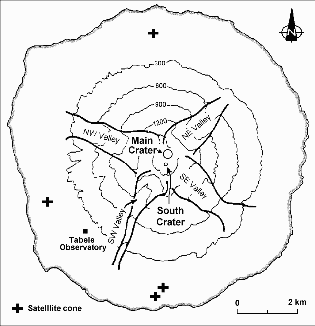 |
Figure 7. Sketch map of Manam Island, showing the distribution of the four valleys. After Palfreyman and Cooke, 1976. |
After the last large eruption in 1992 (BGVN 17:09-17:11), Main Crater remained inactive with weak vapor emissions, while South Crater showed intermittent phases of weak to moderate, mainly Strombolian, activity. Mild Vulcanian explosions resumed at both craters in mid-September 1996 (BGVN 21:09), and Strombolian eruptions returned to both craters in October. During October and November, five strong phases of activity occurred at Main Crater at intervals of 7-12 days; four of them were preceded or accompanied by moderate activity at South Crater (figure 8). From early October to 10 November, the first four phases progressively increased in strength, and were accompanied by a large buildup in seismic amplitude (figure 9). Like the strongest phase of the 1992 eruption (BGVN 17:09-17:11), the first four phases of eruptions at Main Crater produced pyroclastic flows and lava flows in NE Valley.
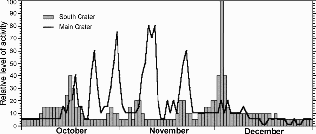 |
Figure 8. A rough (qualitative) estimate of the level of October-December volcanic activity at Manam. Activity is shown as a relative scale that is arbitrary, with the highest intensity artificially set at "100". Courtesy of RVO. |
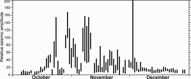 |
Figure 9. Relative seismic amplitude during October-December at Manam. Courtesy of RVO. |
At South Crater, ash-laden emissions, roaring sounds, and fluctuating glows occurred on 19 November, and moderate Strombolian projections (200 m high) and ash-laden emissions (~700 m high) were observed on 20-21 November. The fifth phase of eruptions at Main Crater took place on 20-22 November. On 20 November, Main Crater produced frequent roaring sounds, bright fluctuating night glows, and up to ~800-m-high brown emissions, indicating deep-seated Strombolian activity. Strombolian eruptions were sub-continuous until 1800 on 21 November, with a 3-km high, dark, convoluting column. Several lava tongues traveled down the upper part of NE Valley, and reached an altitude of 600-700 m. On 22 November two lava flows moved down to an altitude of ~200 m in the central and N parts of the valley. On the afternoon of 22 November, the fifth eruptive phase declined, and the Strombolian activity changed to 2-3 km high, thick, gray emissions, which were accompanied by jet sounds. Frequency, volume, and height of the emissions progressively decreased during the next two days.
On 28 November, eruptive activity at South Crater increased with the emissions of weak to moderate, gray-brown plumes (up to 500 m high) and occasional Strombolian projections (~50 m high). On 29 November, emissions became sub-continuous. In the next two days Strombolian projections progressively rose as high as 100-200 m above the crater. At Main Crater, white to gray ash clouds were occasionally released, and glow was seen at night from two locations on the NE rim of the crater. On 30 November, emissions at Main Crater were thick and continuous, but no strong activity was observed.
Strombolian explosions at South Crater increased in strength (occasionally up to heights of 400 m) and frequency (at 1-2 minute intervals) on the morning of 2 December, died out in the afternoon, then resumed in the night. On the morning of 3 December, Strombolian explosions occurred at ~1 minute intervals with ~200-m-high projections, and light gray plumes rose ~500 m high. Seismicity increased but was still in the normal range. Strombolian projections were sub-continuous until 1300, and reached as high as 300 m above the crater. At 1430 explosions took place every a few seconds with heavy scoria falls on the upper cone, similar to the situations in the strongest phases of the 1984, 1987, and 1992 eruptions (SEAN 09:02, 09:03, 12:06, and BGVN 17:09-17:11), which sent pyroclastic flows and lava flows into the SE and SW Valleys.
Large pyroclastic flows started to move into SE Valley at about 1500, and into SW Valley around 1505. The central eruption column became thicker as it incorporated the ash cloud elutriated above the pyroclastic flows. At 1510 ash clouds that were generated by the pyroclastic flows moved down SE Valley and extended over the ground at 400-600 m above sea level. At 1515 the dark central billowing pillar reached an altitude of ~5 km, and spread W of the island. Dense ash and scoria falls caused darkness in the W part of the island for 90 minutes. Pyroclastic flows continuously moved into both SE and SW Valleys at short intervals. At 1520 one large pyroclastic flow in SW Valley reached the sea and was followed by many others. Approximately at that time, pyroclastic flows overran the village of Budua Old, resulting in 13 deaths. The devastated area extended ~1.5 km on either side of the central channel of SW Valley. In SE Valley, pyroclastic flows started to reach the sea around 1530. The overriding ash clouds progressed <100 m offshore. However, within ~10 minutes bubbles were seen piercing the water surface as far as 500 m offshore, indicating that underwater propagation of the hot pyroclastic flows reached quite a distance from the shoreline.
The central column was very dense. Eruption sounds were muffled to a continuous deep roar. Although emitted at South Crater, some pyroclastic flows moved into NE Valley and descended to mid-slope, but none was able to override the 100-m vertical valley walls that protect the cultivated and inhabited flanks of the island. At 1605 the pitch of the roaring sound slightly decreased, indicating the beginning of decline in eruptive activity. By 1615 pyroclastic flows no longer reached the sea, and at 1630 all pyroclastic flows stopped. At 1645-1700 ash began to fall again on the downwind (W-NW) side of the island. At night Strombolian activity continued at South Crater, with ~3 loud explosions every hour. At 0925 on 4 December, a large hot avalanche moved down SW Valley to an altitude of ~20 m. Explosions occurred at South Crater with decreasing strength and frequency until 7 December.
At Main Crater, two vents were active with intermittent, thick, dark, convoluting clouds on the morning of 3 December. Moderately thick, gray clouds were observed rising 500-1,000 m above the crater, with weak night glows until 15 December.
The paroxysmal eruption on 3 December changed the configuration of South Crater by sculpting a 100-m-deep, V-shaped crack NW-SE across the summit. There was an absence of high-frequency earthquakes during and after the paroxysm. This suggested that the crack, which had a similar alignment to one pair of valleys, may have pre-dated the eruption, having been covered by earlier eruption debris. Blocks up to 4 m in size from the crater wall were found in pyroclastic-flow deposits in the lower part of SW Valley.
Neither the start of the 1996 eruption nor its strong phases were anticipated by monitoring results. Ground deformation, monitored by the water tube tiltmeters at Tabele Observatory (figure 7), showed steady conditions between April and mid-September. Resumption of activity at both craters in mid-September accompanied a hardly discernible radial deflation (~0.5 µrad). From then to 8-12 November, the tiltmeters accumulated a barely significant ~1 µrad radial inflation, and thereafter a slight deflation (~1 µrad). However, a remarkable deflation of ~1.5 µrad was recorded during the paroxysm at South Crater.
Reference. Palfreyman, W.D., and Cooke, R.J.S., 1976, Eruptive history of Manam volcano, Papua New Guinea in Johnson R.W. (ed.), Volcanism in Australasia, Elsevier, Amsterdam, p. 117-131.
Information Contacts: B. Talai, I. Itikarai, and P. de Saint Ours, RVO; NOAA/NESDIS Satellite Analysis Branch; Room 401, 5200 Auth Road, Camp Springs, MD 20746, USA.
Larger outburst on 11 February follows mild January activity
Following the disastrous eruption of December 1996 (BGVN 21:12), Manam only showed mild activity throughout January. Seismic activity was generally low and monitoring was discontinued on 28 January. The water-tube tiltmeters at Tabele Observatory (4 km SW of the summit) have shown no changes since the slight drop following the December eruption.
South Crater released gentle pale ash clouds at irregular intervals. Weak rumbling and roaring sounds were heard on 9, 22, 26, and 28 January. South Crater gave off night glow on 22 January and weakly emitted incandescent material on 28 January.
On most days, emissions from the Main Crater consisted of gentle continuous white vapor. Some ash emission occurred on 12 and 22-23 January, accompanied by weak roaring and rumbling sounds, and incandescent projections at night. All combined, the resulting ash clouds were generally low, rising to ~2,500 m altitude and were blown to the SE side of the island where they resulted in light ashfall.
At least two aviation reports gave warnings to pilots (SIGMETs) about Manam's 11 February plumes. The reports indicated the plumes reached ~7 km altitude.
Information Contacts: B. Talai, D. Lolok, P. de Saint-Ours, and C. McKee, RVO.
January calm ends; vigorous early February discharges
Manam's summit crater activity was more vigorous in early February than in January. On 3 February South Crater made rumbling sounds and issued moderately thick, dark gray ash clouds to 600 m altitude. Weak fluctuating night glow was seen and ash fell on the island's E side. The number and strength of explosions increased over the next few days. On the night of 7 February, incandescent lava fragments were thrown ~130 m above the summit.
On 8 February, Strombolian eruptions from South Crater produced ash columns to 2-4 km height; associated pyroclastic flows advanced into the SE and SW radial valleys. Night glow began to decline after that; the last ash emission from South Crater took place on 15 February. Weak glow was seen on the nights of 24, 26, and 27 February.
At Main Crater ash emissions resumed on 5 February. On the 9th an ash column rose to 4-5 km altitude. Similar ash columns were seen over the next few days, though only rising to ~2 km altitude. On the 10th and 11th the crater ejected pyroclasts and produced a weak fluctuating glow; over the next few days the eruptive intensity declined. During 9-12 February, ash fell on the E, SW, and W flanks.
Three times on 11 February (0436, 0703, and 1237 GMT), aviation meteorologists at the Darwin Volcanic Ash Advisory Center issued reports that Manam erupted to 7 km; the ash cloud was predicted to drift S-SE, or W. Satellite data revealed weather clouds in the area and analysts were unable to distinguish an ash plume.
By 14 February the eruption column only rose to ~500 m. During 15-21 February, Main Crater primarily issued weak vapor-and-ash emissions. Larger amounts of ash were noted in the column beginning on 22 February and continuing until the end of the month. Although no seismic measurements were made during February, on the SW flank (4 km from the summit at the Volcano Observatory) the volcano tilted slightly southward (0.5 µrad).
Information Contacts: B. Talai, H. Patia, D. Lolok, P. de Saint Ours, and C. McKee, RVO; Bureau of Meteorology, Northern Territory Regional Office, P.O. Box 735, Darwin, NT 0801, Australia.
Activity low with increase near the end of the month
During March, Manam was only mildly active and visibility was poor. When visible, the crater was gently emitting a white plume and on two nights there were reports of crater glow. Activity increased slightly during the last week of March. Main Crater had white-to-gray emissions accompanied by occasional weak roaring. Aviation reports noted that at around 1600 on 22 March an eruption plume rose to 3,000 m and drifted SSE. The Tabele water-tube tiltmeter recorded a slight but steady radial inflation.
There was a slow and steady rise in seismicity throughout the month. The number of low-frequency earthquakes increased from ~1,400-1,600 events/day. The amplitude of the events also increased with time.
Information Contacts: B. Talai, H. Patia, D. Lolok, P. de Saint Ours, and C. McKee, RVO; Bureau of Meteorology, Northern Territory Regional Office, P.O. Box 735, Darwin, NT 0801 Australia.
Outburst on 6 April sends ash clouds to 1 km
A brief period of heightened emissions took place at South Crater in early April. Following several days of weak vapor emission only occasionally containing a little ash, on 6 April the crater continuously discharged thick gray ash clouds that rose to ~1 km above the summit. The emission was accompanied by roaring sounds heard at 5- to 10-minute intervals. At night incandescent lava fragments were ejected hundreds of meters above the summit. Similar activity persisted over the following two days although at a slightly reduced intensity.
South Crater emissions weakened significantly after 9 April and then waned through the remainder of the month. Crater glow was seen on most nights until 20 April. Emissions typically contained ash until 21 April. During the rest of the month the only emissions at South Crater consisted of gentle, weak to moderate, white vapors.
Main Crater produced only white vapor during the first five days of April and then began emitting weak to moderate amounts of ash on many days, particularly in the last week of April. Weak to very weak crater glow was seen on two nights (1 and 12 April).
As of 22 May, the seismic records for the first three weeks of April had not yet been analyzed. Seismicity in the last week of April was weak to moderate with ~300-800 low-frequency earthquakes/day. Seismic amplitudes were low. Measurements from the water-tube tiltmeters 4 km SW of the summit lacked any apparent trend.
Information Contacts: B. Talai, H. Patia, D. Lolok, P. de Saint Ours, and C. McKee, RVO.
Continued outbursts and light ashfalls
During the first week of May, Main Crater gently emitted small to moderate ash clouds, similar to those in late April. On 9 May, activity increased slightly and ash clouds were ejected to 500-1,000 m above the summit resulting in light ashfall downwind. Forceful emissions and light ashfalls at Main Crater occurred on the 13th; there were also two loud explosions during 1500-1600. After that, there were weak-moderate ash emissions accompanied by roaring noises and infrequent rumblings. Rumblings on the 6th and 28th were attributed to rocks cascading into Southwest Valley. Activity increased again on the 29th. South Crater weakly emitted steam during May.
Seismicity showed an irregular rise during May (growing from 800 to 1,700 low-frequency events/day). Wave amplitudes, although low, doubled. Water-tube tiltmeters at Manam Volcano Observatory (4 km SW of the summit) showed a very small inflationary change (0.5 µrad), which may be significant because it continues the inflationary pattern evident since early March.
Information Contacts: B. Talai, D. Lolok, P. de Saint-Ours, and C. McKee, RVO.
Mild ash emissions and low seismicity during June
At Manam's Main Crater, mild activity prevailed during June. In the first few days of the month emissions consisted of occasional small-moderate ash clouds to several hundred meters above the summit and very fine ashfall in the NW part of the island. Weak white vapor came from the volcano during 5-19 June. On the 19th viewers began seeing occasional small to moderate ash clouds; these continued until the 22nd. During this time fine ash again fell on the NW part of the island. During 23-30 June Main Crater chiefly emitted thin vapor. Throughout June, audible noises and summit glow remained absent.
At Southern Crater during June there were mainly weak emissions of thin white vapor. On the 28th, however, occasional white-gray ash clouds were observed.
Seismic activity was low. The daily number of low-frequency events was 140-1,600 per day. The lower daily totals took place during a period of very low summit activity (8-17 June). Data taken by the water-tube tiltmeter lacked clear trends.
Information Contacts: Ben Talai, RVO.
Ash clouds rise 5 km during July
Aviation reports on 22 March reported Manam's ash plumes rising up to altitudes of 1.7 and 3 km. The plumes drifted S-SE and scattered. Another report described an ash cloud to 3 km on 8 August.
A brief episode of relatively forceful ash emissions occurred at Southern Crater in mid-July. During late June through mid-July, Southern Crater occasionally emitted small-to-moderate ash clouds that rose several hundred meters above the summit. These ash clouds blew NW, resulting in light, fine ashfall.
Water-tube tiltmeters at Manam Volcano Observatory (4 km SW of the summit) underwent 2 µrad of inflation after 1 July, a change as strong as seen during the November-December 1996 eruption. On 11-13 July more robust ash clouds were ejected to 600-1,000 m above the summit resulting in light ashfall downwind. Continuous and forceful ash emissions occurred on 14 July, producing ash clouds that rose over 2 km. Around this time rumbling and roaring noises were also heard. Ash again fell on the NW side of the island. On 15-18 July, ash emissions became weak to moderate; during the rest of July, emissions remained gentle, vapor-rich and weak-to- moderate.
Weak discharges of incandescent lava fragments were only seen on the 11th. Weak night time glows were visible on 11-14 July, 17-18 July, and 25-31 July. Weak steady night glow was visible on 16, 18, and 29 July.
Seismic activity was moderate throughout July. Numbers of low frequency events ranged from 1,000-1,400 per day. Seismic amplitudes gradually increased reaching a peak on the 12th (2 days prior to the month's strongest eruptive phase); thereafter, the amplitudes declined through the month's end.
Information Contacts: B. Talai and H. Patia, RVO.
Low-level eruptive activity at Main and Southern craters
Low-level eruptive activity continued at Main and Southern craters during August. In the first week of the month Main Crater emitted occasional pale gray ash clouds accompanied by low rumbling sounds. On the 13th, occasional gentle emissions of pale gray ash clouds occurred once more. By 18 August emissions became forceful and darker, richer in ash content, and were accompanied by low roaring sounds. Activity started to decrease on 20 August and by the end of the month only gentle ash emissions were observed. A weak steady red glow was observed around the crater mouth on the 28th.
Southern Crater occasionally emitted gentle pale gray ash clouds with low ash contents in August. Low rumbling sounds occurred only on the 4th and 6th. Continuous weak steady red glow around the crater mouth was noted every night. Small sub-continuous projections of glowing lava fragments were observed at nights during 6-9 August. The emissions rose to ~2,000 m altitude then were blown NW, causing light ashfalls on settlements along the coast.
There was no seismic recording until 15 August. On the 19th four small B-type events were recorded. Seismicity suddenly increased on 21 August with 1,320 events recorded. Seismic activity on the following days remained at moderate levels with 1,000-1,360 events/day. The water-tube tiltmeter at the observatory did not show any significant tilt changes during the month.
Information Contacts: Ben Talai, RVO.
Few earthquakes, gentle steaming, and nighttime crater glow
Seismicity remained low throughout September with 700-1,500 low-amplitude events measured per day. A water-tube tiltmeter 4 km SW of the summit showed no significant deformation. South Crater was quiet with continual gentle white-to-blue vapor emissions. A steady, dull glow was observed at nights. This glow ceased sometime between the 25th and 30th of the month (the summit was obscured by cloud between these dates). Main Crater emitted varying amounts of white vapor with an occasional gray tinge. No noise or glow was discernable.
Information Contacts: B. Talai and H. Patia, RVO.
Weak eruption on 26 October
After several weeks of weak-to-moderate vapor emission, South Crater produced a small eruption on 26 October, sending thick white-gray ash clouds ~500-600 m above the summit. Roaring and rumbling noises accompanied the ash emissions. Weak projection of incandescent lava fragments was visible at the crater area. The activity persisted until 28 October but at a slightly reduced level. During 29-31 October activity diminished, releasing only white vapor at weak-to-moderate rates. Summit crater glow was visible throughout October.
Main Crater remained quiet during October, releasing gentle emissions of white vapor. No noises were heard and no night glow was visible at the crater. Seismic activity was moderate throughout October, with ~1,100-1,400 low-frequency earthquakes/day.
Information Contacts: B. Talai and H. Patia, RVO.
Moderate explosions in late November
Moderate activity dominated during November except for the last week, when Vulcanian explosions occurred at Main Crater. The mild level of activity at Main Crater that began in late August continued until mid- November. Beginning on 23 November, the crater released thicker white and gray emissions. Moderate Vulcanian explosions (~700 m above the crater) started on 27 November and produced fine ashfalls. South Crater noiselessly and gently released thin to thick white vapor; a weak steady glow was visible on most nights during November.
Instrumental observation revealed no significant change in seismicity (~1,200 to 1,400 low-frequency events/day of small amplitude). Steady radial inflation of 1 µrad was detected at the Tabele observatory (4 km SW).
Information Contacts: Patrice de Saint-Ours, RVO.
Moderate explosive activity during December
Except for a few Vulcanian explosions at both craters during the first half of the month, moderate activity continued through December.
At Main Crater, mild Vulcanian explosions started at the end of November and prevailed until mid- December. The explosions' plumes rose more than 500 m above the crater resulting in ashfall on the island. A gray vapor of varying density was seen throughout the month.
Southern Crater activity increased following 29 November. Ash-producing explosions rising more than 600 m above the crater continued until 5 December. A weak but steady glow was visible nightly until 6 December. The usual emission was thin (sometimes thick) white vapor. Wisps of blue vapor were seen only on 2, 3, and 31 December.
Seismicity was moderate throughout the month with ~700-1,500 low-frequency, small-amplitude daily events. The water-tube tiltmeter at Tabele (4 km SW of the summit) showed a steady radial inflation of 1 µrad.
Information Contacts: Ben Talai, RVO.
Weak vapor emissions and night time crater glow
Activity at both Southern and Main craters dropped to a low level in January following moderate activity during November-December 1997 (BGVN 22:11 and 22:12). Emissions from both craters consisted of weak to moderate white vapor. Southern Crater produced low roaring noises on 15 January and steady weak glow most nights during 8-31 January.
Seismicity showed no significant change with 1,000-1,400 low-frequency, low-amplitude earthquakes per day. Measurements from the Tabele water-tube tiltmeter showed a 1 µrad deflation.
Information Contacts: Ben Talai, RVO.
Low-level vapor emission and nighttime summit-crater glow in February
Activity at both summit craters of Manam was low throughout February. Both craters emitted continuous weak white vapor. Glow was observed at Southern crater on the nights of 3, 5-9, 14-18, and 25-27 February, but there were no sounds.
Seismic activity showed no significant change: 1,100-1,300 low-frequency earthquakes of very low magnitude were recorded daily. Following a deflation of ~1.5 µrad in January, radial tilt as measured at Tabele stabilized for February.
Information Contacts: Ben Talai, RVO.
Weak vapor emissions, low seismicity, and deflation
Weak to moderately thick white vapor emissions from both South and Main craters prevailed at Manam throughout April. No sounds were heard and no night glow was seen. Seismicity remained low, with 1,300-1,400 low-frequency, very low-amplitude events occurring per day. Water-tube tiltmeters at the Tabele Observatory (4 km SW of the summit) showed continued deflation; it has totaled ~3 µrad since mid-December 1997.
Information Contacts: Ben Talai, RVO.
Short-lived Vulcanian episode unsettles month of mild activity
Mild activity from Manam's two summit craters continued throughout May. Emissions at both Southern and Main craters chiefly consisted of white vapors released at weak to moderately high rates.
An hour-long Vulcanian episode occurred on 21 May. At 1300 a single large explosion at Southern crater produced a gray-brown ash cloud that rose ~ 500 m above the crater, followed by occasional gray ash emissions at 3-5 minute intervals. The ash clouds drifted to the SE of the island leaving a fine ashfall in its wake. There was no visible glow at night.
Seismicity remained at low levels. From 1,100 to 1,400 low-frequency events of very low amplitudes were recorded daily. The water-tube tiltmeter at Tabele Observatory, 4 km SW of the summit, showed an inflation of 2 µrad prior to the Vulcanian phase of 21 May, which remained to the end the month.
Information Contacts: Ben Talai and H. Patia, RVO.
Mild activity; a few weak ash emissions in June
Mild activity prevailed at Manam in June. Both Main and South craters continued to emit weak-to-moderately thick white vapor throughout the month. However, Southern Crater's emission was briefly punctuated by a weak projection of ash at 1900 on 26 June that rose 600 m above the summit. Main Crater also showed glimpses of increased activity with weak emissions of ash on 29 and 30 June. No glow was visible at night from either crater.
Seismicity remained low: 820-1,400 daily low-frequency events of very low amplitudes. The water-tube tiltmeters at Tabele Observatory (4 km SW of the summit) showed an inflation of 1 µrad during the month.
Information Contacts: Ben Talai, RVO.
Weak emissions of white vapor during July and August
The summit area of Manam was obscured for almost half of the month of July. When weather was clear, emissions of weak white vapor were observed from Southern Crater. Main Crater released weak-to-moderate volumes of white vapor. Manam was generally quiet during August with only discrete small emissions of pale-gray ash clouds from Southern Crater on 2, 3, 21, and 25-31 August. Ash clouds rose 500 m above the summit and were blown NW of the volcano resulting in light ash falls. Ash emissions were not accompanied by any audible sounds and there were no night glows above the summit craters. When there were no ash emissions occurring, Southern and Main Craters released small volumes of white vapor.
Seismicity remained at a low level. Counts of low-frequency volcanic events remained generally unchanged from previous months with about 980-1,420 B-type events of very low amplitude being recorded daily. The water-filled tiltmeter at Tabele Observatory (4 km SW of the summit) showed about 1 µrad of inflation in July and was relatively steady throughout August.
Information Contacts: Ben Talai, RVO.
Intense eruptive activity resumes in late September
An inflation of ~10 µrad for September was recorded at Tabele Observatory, ~3 km SW of the summit. This deformation, together with increased seismicity, audible rumblings, and night glow evident in the middle of the month, was thought to indicate the onset of renewed activity.
Intense eruptive activity resumed at Manam in late September for the first time since its fatal eruption of November-December 1996. A visible increase in activity started during 23-26 September, with intermittent dark ash emissions and incandescent projections at night to ~200 m above South Crater. On subsequent days activity decreased to continuous white vapor emissions, first profuse then very weak, and occasional roaring sounds and fluctuating red glow. This corresponded to a slight decrease in seismic amplitude levels, but the radial tilt kept showing inflation.
Significant eruptive activity throughout October, including ash emissions, pyroclastic flows, and lava flows, will be described in the next issue.
Information Contacts: Patrice de Saint-Ours, Steve Saunders, and Ben Talai, RVO.
Energetic outbursts lead to pyroclastic flows, lava flows
Following one month of build-up in seismicity and radial tilt (figure 10), intensive eruptive activity resumed on 5 October 1998—the first since its fatal eruption of November-December 1996 (BGVN 21:12).
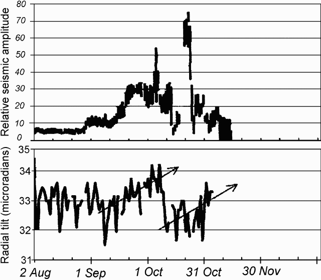 |
Figure 10. Seismicity and radial tilt from a water-tube instrument at Manam, August-October 1998. Courtesy of RVO. |
Visible increases in activity started on 23-25 September, with intermittent dark ash emissions and night-time incandescent projections to ~200 m above South Crater. In subsequent days of October, the activity decreased to continuous white vapor emissions, first profuse then very weak, and occasional roaring sounds and fluctuating glow. This corresponded to a slight decrease in seismic amplitude levels, but the radial tilt continued to show inflation.
On the morning of 5 October a rapid build-up of activity took place. At 0800 ash emissions became forceful, rising ~2 km above South Crater. By 0815 the first small pyroclastic flows started down SE Valley at 5-10 minute intervals. At 0850, the now-dark ash column rose ~3 km, surrounded by blue vapor. Pyroclastic flows started at 0913, penetrating down SW Valley, and the island's E side underwent heavy ash and scoria fall. After 1020 this crater produced several loud explosions every 10-15 minutes. Loud roaring and banging starting at 1205 heralded a decline in activity. By 1600, thick, dark clouds still rose intermittently, but by 1800 only weak, thin gray emissions were visible. Roaring and banging sounds were heard through the night. Although short-lived, this phase also fed a lava flow into SE Valley that branched into two lobes below 900 m elevation and stopped at ~450 m. A lava flow also started toward SW Valley but stopped at the headwall.
In the following days, the tiltmeter 4 km from the summit (at Tabele Observatory) recorded a drop of 2 µrad while the seismicity decreased to near background levels. Until 15 October, gray ash clouds and occasional deep roaring sounds were observed. Not even red glow remained. By the evening of the 16th, red glow reappeared and incandescent projections rose 100-200 m above South Crater. On 17 October, dark ash clouds rose forcefully with rumbling sounds, and minor ash fell on the island's N side.
On the 18th, Main Crater occasionally emitted gray-brown plumes to 600-700 m, and the seismic amplitude increased. Activity in South Crater became sub-continuous, with incandescent projections to 1,000-1,100 m. On the morning of the 19th, a lava flow issued by South Crater descended into SW Valley. The strength of the eruption declined after 1415 and again after 1600. Yet, by 2225 there was a fountain of incandescent projections 1,400-1,600 m above the crater accompanied by loud roaring all night.
Emissions on the morning of the 20th comprised a thick, dark, ash-laden column. In the afternoon, small pyroclastic flows at 1415 and 1750 reached only to the head of SW Valley. By that time, the lava flow extended to within ~2 km of the coast. A single large explosion at 1715 ejected ballistic blocks 1,500 m above the crater. That night, on-going Strombolian explosions rarely reached 1,100 m above the crater.
On the 21st, Main Crater produced dark columns, rising to ~1,000 m, while the roaring Strombolian eruption persisted in South Crater. That night, small tongues of lava flowed in the upper SE Valley.
Activity began to decrease on the 23rd, when the Strombolian projections gave way to intermittent dark ash clouds to ~800 m above the crater. After 1000 on the 23rd, rumbling diminished. The next day Main Crater forcefully ejected dark columns with ballistic fragments and South Crater continued to issue subdued white emissions, with occasional ones that were gray and forceful. This activity persisted until the end of the month, without sound except for occasional low roaring and a faint glow.
While the seismicity noticeably reflected the variations in eruptive strength, tilt was not affected by the second eruptive phase and it resumed rising steadily thereafter as late as early November (figure 10).
Information Contacts: Ben Talai and Patrice de Saint-Ours, RVO.
Pyroclastic flows and lava flows in November
Volcanologists observed pyroclastic flows and lava flows at Manam in mid-November and mild Strombolian eruptions during the last week of December.
November activity. In early November, Main Crater emitted pale gray ash clouds at irregular intervals, accompanied by roaring and rumbling, while South Crater released both white vapor and ash clouds that rose 500-800 m. On 6 November, following deep roaring and rumbling sounds, both craters emitted thick, dark, convoluting clouds that rose 600 m above the summit. Beginning at 0047 on 7 November, very loud explosions blasted out of South Crater at 5-20 minute intervals. The explosions led to ash columns that sent pyroclastic flows ~1 km down the SW valley. Later emissions produced a steadier and more forceful dark gray cloud accompanied by large explosions 20-60 minutes apart. At 1938 a large explosion sent pyroclastic flows ~2 km down the SW valley. Similar explosions were heard during the next few hours and incandescent projections were seen. A strong explosion at 2334 produced pyroclastic flows that ran ~2 km down SW Valley and 1 km down the SE valley. Similar activity continued until 10 November.
During the morning of 13 November frequent explosions led to small pyroclastic flows; later activity was irregular and accompanied by roaring noises. Activity increased at 1637 and sometime before 1900 lava began fountaining 180-350 m above the crater rim. Lava then spilled over the rim and flowed ~1-2 km down the SE and SW valleys. Ash emissions and loud noise were continuous while the lava was flowing. At 2100 the ash column abated, sending pyroclastic flows into the NW valley.
At 0221 on 14 November a voluminous ash column was produced and lava fragments ejected ~400-500 m above the summit. The incandescent projections within this column lit the mountain spectacularly. Later a very thick, dark gray ash cloud rose ~2 km above the summit and lava flowed ~2 km down the SE and SW valleys. Most ashfall was toward the SE, but a shower of ash with grain size of 1.5-2.0 mm fell at Tabele Observatory 4 km to the SW. Activity ended at about 2100 and afterward there were no noises heard or glows seen. From then until the end of the month activity at South Crater was restricted to mostly thin, white vapor emissions.
December activity. Emission from South Crater from 30 November to 20 December consisted mostly of white vapor with an occasional ash cloud rising 500 m above the summit. The ash clouds drifted SE and left a fine ashfall. Weak roaring noises were heard during 1-2 December and weak but steady glow was visible on the 1st.
A brief episode of Strombolian activity occurred on 24 December. At 1217 deep, weak explosions were followed by discontinuous, forceful emissions of dark-gray, convoluting clouds that rose 1,000-1,200 m above the summit. The emissions occurred at 1-2 minute intervals accompanied by roaring sounds. The activity continued until 1330 before declining to occasional emissions of thin, gray ash clouds. At night projections of incandescent lava fragments reached 200 m above the summit. Fine scoria and ashfall were reported on the SE of the island. During the next two days, moderate emissions were sometimes accompanied by forceful ejections of thick, dark gray ash clouds rising 800 m above the summit. A fluctuating glow and weak projections of glowing lava fragments were visible. From the 28th until the month's end South Crater released only white vapor while Main Crater released white vapor with occasional pale gray ash.
Geophysics. A steady accumulation of tilt took place before mid-November; it measured ~2 µrad at the radial water-tube tiltmeter of Tabele Observatory heralding renewed eruptive activity. Although during the mid-November eruption tilt appeared unaffected, seismicity reflected the changes in eruptive intensity; after 20 November a deflation of ~1.5 µrad was recorded. During 1-21 December, the tiltmeter recorded an inflation of ~1 µrad.
Information Contacts: Herman Patia, RVO.
Continuing Vulcanian activity at Main Crater
Emissions through January at Main Crater were generally pale brown, low in ash content, and were accompanied by roaring and rumbling sounds. There was no night glow. Ash clouds rose ~500 m above the summit and resulted in occasional ashfalls on the NW side of the island.
Southern Crater continuously released a small volume of white vapors. Only once, on 1 January, a small emission of pale gray ash was seen. Faint, fluctuating glow was observed around the center on most nights.
Seismicity remained at a low level with about 1,200-1,420 low-frequency B-type events of very low amplitude recorded daily. The water-tube tiltmeter at Tabele Observatory (4 km from the summit) showed no significant change. Since the Strombolian eruption on 21 December, the tilt trend was generally flat.
Information Contacts: Herman Patia, Rabaul Volcano Observatory (RVO), P.O. Box 386, Rabaul, Papua New Guinea.
Mild eruptive activity at Main Crater; Southern Crater is quiet
Mild, irregular, eruptive activity continued from Manam's Main Crater, while Southern Crater remained quiet. Main Crater continued to emit minor pale gray ash intermittently throughout March and April, with emissions rising to ~500 m above the summit before being blown to the NW with resulting fine ashfall. There were no reports of any noise or nighttime glow. Southern Crater was quiet, releasing white vapor only. However, a weak steady red glow was visible during 17-21 April. Seismic activity was low and there were no significant change in ground deformation.
Information Contacts: Herman Patia, Rabaul Volcano Observatory (RVO), P.O. Box 386, Rabaul, Papua New Guinea.
Ashfalls and infrequent explosions
Mild to weak eruptive activity from Main Crater continued in May and June. During May there were small to moderate pale gray ash emissions. Ash clouds then rose 500-600 m above the summit before being blown NW with resulting light ashfall on 1, 22, 26-27, and 31 May. A slight wind change on 15 and 25 May caused the ash clouds to drift SW and the ashfall to move downwind. There were no noises or night glow observed in May. A weak, steady glow was visible between 2 and 5 May.
Although Southern Crater was generally quiet with only thin white emissions, a small explosion took place on 10 June. A weak discharge of lava fragments accompanied loud noises that lasted only a short time. Later, on 26 June, Main Crater vented gray-brown ash clouds resulting in ash fall over some parts of the island.
During May-June, seismicity remained low. Evidence for deformation was absent at the water-tube tiltmeter located at Tabele Observatory, 4 km from the summit on the SW flank.
Inhabitants of the 10-km-wide island of Manam reside on one of Papua New Guinea's most active volcanoes. Four large radial valleys extend from the unvegetated summit of the conical stratovolcano to its lower flanks. These "avalanche valleys," regularly spaced 90 degrees apart, channel lava flows and pyroclastic avalanches that have sometimes reached the coast. Five satellitic centers are located near the island's shoreline. Two summit craters are present and both are active, although most historical eruptions have originated from the southern crater and drained into the SE avalanche valley. Frequent historical eruptions have been recorded since 1616.
More recent activity began in December 1956 and lasted through January 1966. Lava flows and a nuee ardente from the South Crater occurred in June and December 1974, and intermittent moderate explosive activity has continued into 1993, with peaks of activity in 1982 and 1984.
Information Contacts: Ben Talai, Rabaul Volcano Observatory (RVO), P.O. Box 386, Rabaul, Papua New Guinea.
Inflationary trend continues; seismic peak in mid-August
Throughout August-October, both Main and Southern Crater emitted varying amounts of white vapor. No noise or night glow was reported in either month. Prior to 13 August, a gray component to the plume was occasionally observed at Main Crater. The summit area was clear during 1-21 September, but was cloud-covered through the end of the month and sporadically during October.
Daily seismicity was at its lowest level in late July, but seismic amplitudes built up slightly until mid-August. Activity decreased subsequently, except one individual peak on 13 August with the highest daily energy level since November 1998. Seismic activity was stable at a low level in September and October.
The seismic peak on 13 August may have been related to an upward tilt toward the summit that built up until 10 August, at which stage it reached a level that has commonly led to increased eruptive activity. However, no significant activity occurred and a gradual down-tilting took place throughout the remainder of August. In September the water-tube tiltmeter 4 km SW of the summit registered ~5 µrad of inflation. The overall inflationary trend continued, with a total of ~20 µrad of inflation recorded between July and the end of October.
Information Contacts: Ima Itikarai, Kila Mulina, and Steve Saunders, Rabaul Volcano Observatory (RVO), P.O. Box 386, Rabaul, Papua New Guinea.
Ash emissions from both craters during November
Mild eruptive activity occurred at Manam's two summit craters during the first week of November. Main Crater released occasional pale gray ash clouds accompanied by weak roaring noises during 2-4 November; no glow was visible at night. The summit was covered on the 5th and 6th. When it became clear on the 7th, it was seen emitting only weak-to-moderate volumes of white vapor. This level of emissions continued until the end of the month and throughout December.
Southern Crater released thin white vapor during the first few days of November. However, activity shifted from Main Crater on the 7th and Southern Crater released pale gray ash emissions at irregular intervals. An explosion at 1140 produced an ash cloud that rose several hundred meters above the summit, resulting in fine ashfall on the NW part of the island. Although both craters were covered by atmospheric clouds on 9th, weak roaring noises were evident. Southern Crater released small-to-moderate volumes of white vapor after 10 November through December.
Seismic activity was low during November. However, there was a slight increase in seismic amplitudes during the first week of the month. This increase coincided with the mild increase in activity observed from the two summit craters. Seismic amplitudes dropped for a while after mid-November 1999. It reached a trough in the second week of December, then began to increase again. The level was still rising at the end of the December. These observations took place within the range of normal background level.
The steady fluctuating inflation measured by the water-tube tiltmeter since July levelled off in late October. No changes were observed in November or December. There was an accumulated inflationary tilt of about 20 µrad between July and late October.
Information Contacts: I. Itikarai, H.Patia, and F. Taranu, Rabaul Volcano Observatory (RVO), P.O. Box 386, Rabaul, Papua New Guinea.
In early 2000 low seismicity, weak ash emissions, and some inflation
Weak activity at Manam continued during 1-16 January, and the months of February and March 2000. (Reports for the second half of the month were not received.) During 1-16 January Main and Southern craters both issued weak white vapor. By the end of the second week of January seismicity had reached a trough similar to that in mid-December. Still, the average number of daily earthquakes was over 1,000 (specifically, 1,160-1,470 except on 3 and 4 January, when they were 820 and 300). The wet tilt readings (available until 5 January) showed minor fluctuations.
Seismicity remained low, with amplitude measurements at normal background level until 18 March, when amplitudes increased slightly but remained within the background range. The higher level continued through March. Event counts were also steady through this period, averaging ~1,200/day, although several days in March had only 500-600. The water-tube tiltmeter ~4 km SW of the summit area measured ~14 µrad of inflation in March. The inflation began sometime in late January 2000.
Information Contacts: I. Itikarai, D. Lolok, K. Mulina, and F. Taranu, Rabaul Volcano Observatory (RVO), P.O. Box 386, Rabaul, Papua New Guinea.
An increase in activity at Southern Crater 3-4 June
This report covers April-June 2000. Inflation that began in January 2000 (BGVN 25:03) peaked in early April. By mid-April the water-tube tiltmeter 4 km SW of the summit detected a 2.5 µrad decrease in tilt. By the end of April the tilt had recovered 1.5 µrad. Emissions from both the summit craters, Main and Southern, consisted of gentle releases of light to moderate volumes of white vapor. Seismicity remained low with the number of events ranging from 500 to 1,200 events a day. Seismic amplitude measurements were steady at background levels.
During May, Manam continued to produce varying amounts of white vapor from both craters. Rabaul Volcanic Observatory (RVO) characterized the seismicity as normal. Tiltmeter readings showed no particular trend.
Throughout June, Main Crater released light to moderate volumes of white vapor. However, during 3-4 June, Southern crater increased in activity.
At 1235 on 3 June, an explosive eruption produced thick, dark ash clouds and produced fine-ash and scoria deposits at Yassa village, W of the summit. The ash clouds reached an altitude of 1-1.2 km. The initial explosion was followed by light to moderate release of ash. At 0004 on 4 June, booming sounds lasting 1-2 minutes were accompanied by the ejection of glowing lava fragments. These fragments fell in the SW valley and had free fall times (FFT) of 5-10 s. Some weak to low fluctuating night time glows were visible during the intervals between lava fragment ejections. Prior to and after the events of 3-4 June, Southern crater produced light amounts of white vapor.
Although there were no water-tiltmeter readings after 19 June, the values taken 4 km S of the crater showed an inflation of 10 µrad from 1-19 June. Since December 1999, there has been an overall inflation of 16 µrad. There were no seismic readings during 1-10 June. Low-level seismicity the remainder of the month had counts ranging from 600-1,360 a day. Seismic amplitude measurements were relatively steady at normal background levels.
Information Contacts: I. Itikarai, D. Lolok, K. Mulina, and F. Taranu, Rabaul Volcano Observatory (RVO), P.O. Box 386, Rabaul, Papua New Guinea.
Low August-October 2000 activity; increased seismicity 18 September
Following the 4 June 2000 eruption at Southern Crater (BGVN 25:07), volcanic activity was low at both summit craters through October 2000. Seismicity remained relatively stable except for a slight increase in amplitudes beginning on 18 September.
During August, activity at the two summit craters was low. Main Crater gently emitted small-to-moderate volumes of white vapor, while Southern Crater weakly emitted white vapor. Seismic-event amplitudes steadily increased throughout the month, though the overall trend remained within background levels. Daily average event counts were about 1,200, with some fluctuations. No significant movements were recorded by the water-tube tiltmeter 4 km SW of the summit.
Activity remained low throughout September, with vapor emissions from both craters similar to those in August. Seismic amplitudes were steady until 18 September when a slight increase was observed that continued through the end of the month. Daily average seismic event counts remained steady, with about 1,300 events/day.
Throughout October both craters emitted varying amounts of white vapor, and there were no reports of noise or night glow. Seismicity and tilt measurements appeared to remain at background levels, although consistent measurements could not be made because scientists did not have access to the Tabele Observatory during 5-21 October.
Information Contacts: Ima Itikarai, David Lolok, Herman Patia, and Steve Saunders, Rabaul Volcano Observatory (RVO), P.O. Box 386, Rabaul, Papua New Guinea.
False report of 25 June lava flows; low-level ash emissions continue
Activity remained low following the 4 June 2000 eruption of Southern Crater. A pilot's report of multiple lava flows traveling from Manam on 25 June along with an ash cloud to 4.5 km was determined to be false. The Rabaul Volcano Observatory reported that the volcano had been quiet for many months and that the only observed activity occurred on 14 June when fine ash was produced from a small emission, and on 26 June when weak roaring/rumbling noises were heard. After 26 June only occasional low-level ash emissions took place. There have been no instrumental recordings since 16 January 2001.
Information Contacts: Ima Itikarai, Rabaul Volcano Observatory (RVO), P.O. Box 386, Rabaul, Papua New Guinea; Washington Volcanic Ash Advisory Center (VAAC), Satellite Analysis Branch, NOAA/NESDIS/E/SP23, NOAA Science Center Room 401, Camp Springs, MD 20746, USA (URL: http://www.ssd.noaa.gov/).
Mild eruptions during January-February 2002
Activity at Manam remained relatively low following a 4 June 2000 eruption (BGVN 25:07). During August and September 2001, the Rabaul Volcanological Observatory (RVO) reported occasional emissions of weak-to-moderate volumes of white vapor. Weak emissions were also observed from South Crater.
On 13 January 2002 mild eruptive activity began from South Crater. Weak gray-brown ash clouds were emitted at 5-10 minute intervals. Fine, light ashfall was reported on the NE side of the island. Ashfall was reported again on 16, 20, 21, 22, 26, 29, 30, and 31 January, produced by activity ranging from gentle emissions to forceful projections of weak-to-moderate gray-brown and occasionally dark-gray ash clouds, during periods lasting a few hours. Most of the activity was accompanied by weak, deep, low roaring and rumbling noises. Explosion noises were heard on 20 January, and incandescence was observed on 17 and 20 January. The incandescence on 20 January fluctuated but occasionally intensified and projected glowing lava fragments.
Similar mild eruptive activity continued through much of February. Fine ashfall occurred on the SE part of the island. Weak-to-bright incandescence was observed on 13 February, after a loud explosion at 0225. The explosion was also followed by weak roaring and rumbling noises at one-minute intervals lasting for ~1 hour. During 20-24 February activity decreased and continuous weak volumes of white vapor were emitted. Main Crater released only weak-to-moderate volumes of white vapor.
People living in and near the four valleys (especially those in the NE and SE) were urged to be cautious and remain away from the valleys as much as possible.
More recently, a period of activity began in December 1956 that lasted through January 1966. Lava flows and a nuee ardente from the South Crater occurred in June and December 1974, and intermittent moderate explosive activity has continued, with peaks of activity in 1982 and 1984. The water-tube tiltmeter is located at Tabele Observatory, 4 km from the summit on the SW flank.
General References. de Saint Ours, P., 1982, Potential volcanic hazards at Manam Island: Geological Survey of Papua New Guinea Report 82/22, 19 p.
Scott, B.J., and McKee, C.O., 1986, Deformation, eruptive activity, and earth tidal influences at Manam volcano, Papua New Guinea, 1957-1982: Royal Society of New Zealand Bulletin 24, p. 155-171.
Information Contacts: Ima Itikarai, Rabaul Volcano Observatory (RVO), P.O. Box 386, Rabaul, Papua New Guinea.
Strombolian eruption on 20 May followed by lower-level activity
Mild eruptive activity began from South Crater on 13 January 2002. Weak gray-brown ash clouds were emitted and fine, light ashfall was reported. Weak, deep, roaring and rumbling noises accompanied occasional explosions and fluctuating incandescence (BGVN 27:03).
The Rabaul Volcano Observatory (RVO) reported that during March 2002 clouds obscured the view, but the vent produced weak-to-loud roaring and rumbling noises at intervals of 5-10 minutes on some days and about an hour on other days. The average interval was about 20-30 minutes. Explosions occurred on 15, 17, 21, 22 and 27 March. Explosions produced projections of dark brown ash clouds that were visible above the cloud cover. Fine ashfall was observed on the SE, and occasionally on the NW, parts of the island on many days of the month. Most ashfall occurred during 14-31 March, coinciding with the period of more numerous and vigorous explosions. Another notable observation was the sound of cascading boulders and rock fragments into the SE valley. These sounds were usually heard following explosions or loud roaring noises. Incandescence was observed on most nights of the month. During 1-13 March, generally steady incandescence varied between a dull and a bright, steady glow, and during 14-31 March the glow was marginally brighter. Occasionally (4, 17, and 31 March), projections of red incandescent lava fragments were observed. Main Crater continued to release only weak-to-moderate volumes of white vapor during periods of visibility. No instrumental (including seismicity) recording was done in March.
A moderate-sized Strombolian eruption occurred on 20 May. A pilot reported an ash plume at a maximum height of ~9 km on 20 May at 0500. At 0945 on the same day an eruption cloud was visible on satellite imagery extending SW. The Rabaul Volcano Observatory reported that a continuous eruption occurred until about 1400 on 20 May. After that, activity consisted of forceful ash emissions in moderate volumes. The decline in activity led to the reduction in Alert Level from 2 ("eruption expected within weeks to months") to 1 ("non-threatening, background level"). According to the Darwin VAAC, the ash cloud produced from the 20 May eruption was no longer visible on satellite imagery by 22 May at 1515. People were reminded to be cautious when near the valleys SE and SW of the volcano.
Information Contacts: Ima Itikarai, Rabaul Volcano Observatory (RVO), P.O. Box 386, Rabaul, Papua New Guinea; Darwin VAAC, Bureau of Meteorology, Northern Territory Regional Office, PO Box 40050, Casuarina Northern Territory 0811 Australia (URL: http://www.bom.gov.au/info/vaac/).
Low-moderate seismicity after May eruption; plume on 31 October
The Rabaul Volcano Observatory (RVO) reported that the Strombolian eruption from Southern Crater of Manam on 20 May (BGVN 27:05) ended the next day after the last ash-laden clouds were released. Activity then declined to emissions of very small amounts of thin white vapor. A seismograph was installed at Warisi village on the SE side of the island on 22 May 2002. This is the first seismograph to be deployed since Manam Observatory was shut down on 16 January 2001. During 22-24 May seismicity was at a moderate level, mainly associated with many low-frequency volcanic earthquakes. During 25 May-2 June seismicity declined and fluctuated at a low level. At 1351 on 31 October 2002 a pilot reported "light brown dust/smoke" from Manam drifting S toward the main coastline at an estimated height of ~3.0 km. A possible thin low-level plume was seen on satellite imagery extending ~18.5 km N at 1425 that day, but was not seen on later imagery.
MODVOLC Thermal Alerts, 2001-2002. Throughout 2001 and 2002, thermal alerts for Manam occurred only in April and May 2002. The first alert occurred on 7 April and may reflect the tail end of 14-31 March activity reported by RVO when ejection of red incandescent lava fragments was observed (BGVN 27:05). MODIS detected no thermal alerts during that period, which could be a result of cloud cover or because activity was too slight or too intermittent to have triggered an alert.
The number of alert pixels and the value of the alert ratio both increased to a peak on 20 May, the date of a moderate-sized Strombolian eruption reported by RVO. The eruption continued until about 1400 on 20 May. Subsequently, activity declined and consisted of forceful ash emission in moderate volumes (BGVN 27:05). The biggest MODIS anomaly on 20 May was detected at 1015 with 10 alert-pixels and a maximum ratio of 0.178. This is five hours after the first known report of activity. After 12 hours the anomaly was smaller with seven alert-pixels and a maximum alert ratio of -0.322. On 21 May the decreasing thermal anomaly was represented by one alert-pixel with a ratio of -0.783.
During the earlier part of May, MODIS alerts suggested noteworthy activity at Manam that has not, to our knowledge, been reported elsewhere. The anomaly dropped briefly to a minimum on 16 May, which could reflect a lull in activity or partial cloud cover.
The centers of most alert-pixels for Manam lie systematically NW of the summit (figure 11). Bearing in mind that the strongest anomaly should occur at the summit and that ejecta appears to have gone mostly to the SE (BGVN 27:05), there is likely a systematic error in geolocation for this volcano on the MODIS thermal alerts site. The shift between the reported daytime and nighttime alert locations on 20 May could be a related effect, attributable to a 20° difference in satellite zenith angle between these two passes.
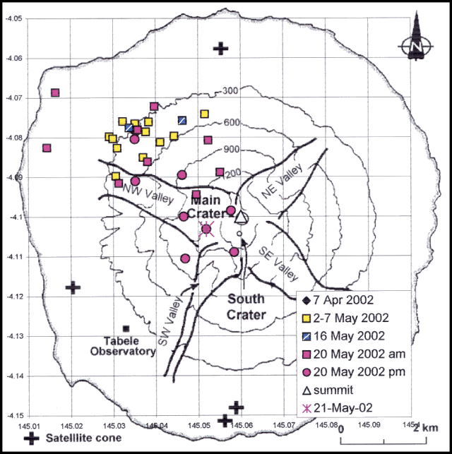 |
Figure 11. Locations of alert-pixels on Manam during 2001-2002. Grid squares are 1 km. Base map is from BGVN 21:12 (after Palfreyman and Cooke, 1976). Courtesy of Diego Coppola and David Rothery, The Open University. |
Reference. Palfreyman, W.D., and Cooke, R.J.S., 1976, Eruptive history of Manam volcano, Papua New Guinea in Johnson R.W. (ed.), Volcanism in Australasia, Elsevier, Amsterdam, p. 117-131.
Information Contacts: Ima Itikarai, Rabaul Volcano Observatory (RVO), P.O. Box 386, Rabaul, Papua New Guinea; Darwin VAAC, Bureau of Meteorology, Northern Territory Regional Office, PO Box 40050, Casuarina Northern Territory 0811 Australia (URL: http://www.bom.gov.au/info/vaac/); Diego Coppola and David A. Rothery, Department of Earth Sciences, The Open University, Milton Keynes, MK7 6AA, United Kingdom.
White vapor emissions from both craters; low seismicity
The summit area of Manam was obscured by rain and atmospheric clouds on most days during January-March 2003, making it difficult to observe emissions from the two summit craters. When clear, the Main Crater released small-to-moderate volumes of thin white vapor. Southern Crater generally released small-volume white emissions. Seismicity was low. Small low-frequency earthquakes were recorded on most days. Slightly greater numbers of earthquakes occurred on 16, 17, 23, 25, and 27 January. Some volcano-tectonic earthquakes were recorded on 11 (1), 12 (1), and 16 January (3); the events on the 16th were larger than the others. No volcano-tectonic earthquakes were recorded in February, and there was no seismic recording during March.
Information Contacts: Ima Itikarai, Rabaul Volcano Observatory (RVO), P.O. Box 386, Rabaul, Papua New Guinea.
Minor ashfall from Main Crater activity during May
Recent activity at Manam has consisted of white vapor emissions from both the Main and Southern craters, and low seismicity (BGVN 28:03). The Rabaul Volcanological Observatory reported that the two vents in the Main crater gently released weak, thin white vapor during 7-12 May, with occasional white-gray emissions on 11 May. Fine ashfall resulting from occasional emissions of thin white gray ash plumes from Main crater was reported on the NW side of the island on 17-19 and 23 May. No audible noise or glow was reported. Southern crater continued to gently release small amounts of thin white vapor. The volcano was quiet over the period 25-30 June, with both craters gently releasing occasional thin white vapor emissions and low seismicity.
Information Contacts: Ima Itikarai, Rabaul Volcanological Observatory, P.O. Box 386, Rabaul, Papua New Guinea.
Occasional ash emissions from Main Crater
Activity at Manam remained low during 10 November-14 December 2003. Occasional emissions of weak to moderate gray-brown ash clouds continued from Main Crater, at a lower level compared to late October-early November. An explosion on 11 November produced an ash plume that rose slowly to ~400 m above the summit crater, causing ashfall to the E. Occasional low rumbling and weak roaring noises were heard on 12 and 28-30 November. No night-time glow was observed during November. A forceful gas emission on 5 December sent an ash column ~500 m above Main Crater, and a steady glow was observed on the night of 10 December. Southern Crater gently released weak thin white vapor gently throughout the period. Small low-frequency volcanic earthquakes continued, with a slight increase in seismicity characterized by sub-continuous volcanic tremors after 1 December.
Information Contacts: Ima Itikarai, Rabaul Volcano Observatory (RVO), P.O. Box 386, Rabaul, Papua New Guinea.
One minor eruption but otherwise low activity during February 2004
Activity at Manam's two summit craters remained low during February 2004. The summit area was cloud covered most of the month; however, when clear, both craters were observed releasing white vapor at weak to moderate rates. A single explosion occurred during the month, on 14 February at Southern Crater. A thick dark gray ash cloud and weak roaring noises accompanied the explosion. The ash cloud rose several hundred meters above the summit before drifting NW of the island, resulting in fine ashfall downwind. There was no nighttime glow observed.
Information Contacts: Rabaul Volcano Observatory (RVO), P.O. Box 386, Rabaul, Papua New Guinea.
Suggestions of mild activity; February and April ash discharges
The Rabaul Volcano Observatory reported that activity at Manam's two main summit craters remained low to mild during February-April 2004. No HIGP-MODIS thermal alerts were recorded at Manam over the year to 11 May 2004. While RVO noted that the summit was covered in cloud for most of February, when it was clear the craters were releasing white vapor at weak to moderate rates. They reported that February's single explosion occurred at the Southern Crater on the 14th; it was accompanied by a thick gray ash cloud and weak roaring noises. The ash cloud rose several hundred meters above the summit and drifted NW producing fine ashfall. There was no night-time glow observed during the month.
Mild eruptive activity occurred at the Southern Crater over the period 15 March-1 April, with emissions of brown ash on 17, 18, 27, and 28 March. The ash clouds rose ~ 100-300 m above the summit and drifted SE, depositing small amounts of ash in the villages of Boakure and Warisi. Vapor was also emitted from Main Crater. Small low-frequency earthquakes occurred over the report period, with a slight increase in the amplitude of volcanic earthquakes on 24 March. Overall the level of seismicity remained low. RVO continued to advise people to stay away from the four main valleys near the volcano.
Information Contacts: Ima Itikarai and Herman Patia, Rabaul Volcano Observatory, Papua New Guinea.
Weak to moderate white vapor emissions during July
Activity at Manam's two summit craters remained low during July. The summit area remained mostly cloud-covered during the month; however, when the clouds cleared both craters were releasing white vapor at weak-to-moderate rates. No seismic recording was carried out due to shortage of recording paper. There was no night-time glow observed during the month. Remote sensing scientists working with the MODIS Thermal Alert System noted that no new activity was detected by MODVOLC from 1 January 2003 to 31 May 2004.
Information Contacts: Ima Itikarai and Herman Patia, Rabaul Volcano Observatory (RVO), P. O. Box 386, Rabaul, Papua New Guinea; Rob Wright, Luke Flynn, and Eric Pilger, MODIS Thermal Alert System, Hawaii Institute of Geophysics and Planetology (HIGP), School of Ocean and Earth Science and Technology, University of Hawaii at Manoa (URL: http://modis.hgip.hawaii.edu/); David A. Rothery and Charlotte Saunders, Department of Earth Sciences, The Open University, Milton Keynes, MK7 6AA, United Kingdom.
Eruption from Southern Crater on 24 October; pyroclastic flows and ashfall
The Rabaul Volcano Observatory (RVO) issued a series of information bulletins on Manam, describing conditions and hazard status recommendations associated with a strong eruption that started on 24 October 2004. That eruption was preceded by a clear buildup in seismicity, leading to a felt earthquake the day prior to the eruption. The eruption generated pyroclastic flows which traveled down the valley SE of the volcano and into the sea. The aviation color code rose to Red, the highest value.
The eruption's plume was imaged from space. Ash and condensed water vapor in the form of ice reached a maximum height of ~ 15 km altitude, intersecting the base of the tropopause but not entering the stratosphere. Low-level eruptive activity persisted after the 24 October eruption.
Lead-up to the 24 October eruption. RVO noticed increased low-frequency earthquakes at Manam beginning 15 October 2004. Its reports suggested the volcanic system had changed to a dynamic mode from its previously stable state. The escalation in low-frequency earthquakes during that interval was described as a "steady rise." But overall, the level was portrayed as low to moderate. In retrospect, RVO reports noted that seismicity increased steadily after 16 October; moreover, it rose further after a felt earthquake at about 1845 on the 23rd.
During 15-21 October RVO noted occasional weak roaring and rumbling noises from the Main Crater. The noises prevailed on 15, 16, and 17 October, becoming more frequent on the 18th, but reduced again on the 19th. The noises continued at a level similar to the 16th and 17th on the 20th and 21st. Noise from Southern Crater began on the 19th, consisting of the sound of a single low explosion. After the 20th, occasional low roaring and rumbling noises continued from both craters. Observers saw night glow from the Main Crater on the 18th and 19th. Occasionally the glow fluctuated at 3-5 minute intervals. Glow remained absent over Southern Crater. Both Craters released weak white-gray vapor.
Occasional ash-laden vapor was seen on the 21st from Southern Crater. In their report for 15-21 October, RVO recommended Alert Level 1. They said "Whilst no official public warning is required under this Alert Level, people living in and near the four main valleys of the Island should be informed to refrain from venturing into them unnecessarily." RVO later stressed the presence of NW winds at altitude, warning residents on that flank of possible ashfall.
Eruption on 24 October 2004. The eruption came from Southern Crater, beginning after 0800 on the 24th; it persisted throughout the morning and the early part of the afternoon, peaking between 1000 and 1100. At 1400 the eruption's intensity decreased slightly. Later that day it continued at a reduced level with moderate explosions and sub-continuous low rumbling and roaring noises.
The eruption produced a pyroclastic flow channeled into the SE valley, that eventually reached the sea. The NW part of the island, including villages between Tabele Mission and Baliau, were affected by ash and scoria falls. Some of the scoriae were fist-size and punched holes through the thatched-roofing of houses. The greatest impact occurred at Kuluguma and the surrounding villages. Casualties remained unreported. Between the hours of 0300 and 0500, residents of Wewak town called RVO, advising that fine ash had reached them.
Seismicity reflected the eruptive activity, with events peaking between the hours of 1000 and 1100, after which event counts reverted to low to moderate levels. Ongoing seismicity suggested that the volcano has not reached a completely quiet state. Still, the eruption level had declined as it continued. It was recommended that the Alert Level be upgraded from 1 to 2 (Stage 2 Alert Level does not call for evacuation from the Island). Authorities called for community information exchange ("toksave") on volcano status; for avoiding the four main valleys; for the population to stay prepared and organized, including village efforts.
The 24 October eruption caused the aviation color code to rise to Red, the highest value. According to RVO, low-level eruptive activity persisted after the 24 October eruption, decreasing further by 26 October. A RVO report issued at 0800 on 27 October noted that activity had subsided significantly since late on the 24th. An aerial inspection confirmed pyroclastic flows had gone down the SE- and upper part of the SW-trending valleys. A lava flow traveled 600 m down the SE valley. Tephra fall most affected the area from Kuluguma to Boda villages, including the Bieng Catholic mission on the island's NW side. Numerous food gardens were destroyed by the tephra deposit, which had an average thickness of 7 cm measured at the Bieng mission. RVO recommended that the Alert Level be downgraded to 1.
On 27-28 October occasional ash emissions still escaped from Southern Crater. Brown ash clouds rose several hundred meters above the summit before drifting to the NW and SW, resulting in fine ashfall. The ash emissions were accompanied by weak roaring and rumbling noises. Weak night-time glows were visible. Although earthquakes were few, tremor persisted. Low seismicity was coupled with a decline in eruptive vigor.
During 28-29 October, comparatively mild eruptions continued. Southern Crater continued to eject occasional emissions of dark, moderately thick, ash-laden clouds. The ash clouds were again blown NW, traversing the area between Yassa and Baliau villages. Low roaring and rumbling noises accompanied some of the activity. It was difficult to observe Main Crater due to cloud cover. Glow was difficult to observe due to cloud cover as well. Few earthquakes occurred, but volcanic tremor continued.
Media reports. News articles reported that authorities advised evacuation of ~ 3,000 people to safer parts of the island. Some of those articles revealed that the island's current population stood at 7,000, and that the government had helped provide food and shelter for those displaced.
According to the online version of the Papua New Guinea (PNG) Post-Courier, the Inter-Government Relations Minister, Sir Peter Barter, flew over the eruption. He allegedly saw large volumes of lava discharging into the sea, but judging from RVO observations, the term "lava" was mistakenly used for pyroclastic flows. In the news report Peter Barter had also stated that the entire SE side of the mountain, ~ 1 km wide, blew out, forcing lava (or other hot pyroclastic material) to flow down the SE valley to the sea. He was also reported as saying that at Bien (sometimes spelled Bieng, on the island's NW coast) his helicopter was hit by rocks (or other volcanic particles) that damaged its windscreen. Also, the Bien mission station lay beneath a heavy layer of ash. The damage to his helicopter kept him from flying completely around the island, missing the western segment between Bien, Yassa, Jorai, and the SW-flank settlement of Tabele, areas hit hardest by dust and rocks. He commented that much of the SE side of the island was relatively ash-free and safe, apart from the S-coast area between Dugulava (on the S coast) to Warisi.
A 27 October article by Dominic Krau in PNG's The National noted that the 24 October eruption had included a forceful outburst at 0800 on the 24th, and then climaxed during 1100-1400 that day, but had since been emitting only "smoke" and ash. It noted that prime minister Michael Somare had flown to Manam for a first-hand look at the damage. The same article mentioned that Peter Barter had assured that functioning radios were available at the settlements of Bien, Tabele, Warisis, Dugalava, Abereia, Bukure, and Kolang. It reported that volcanic ash fell in Wewak (on the main island's coast, 120 km NW), resulting in the civil aviation authority temporarily closing down the Boram airport for safety reasons.
Andrew Tupper of the Australian Bureau of Meteorology (BOM) posted satellite images of the 24 October eruption's ash cloud, which occurred just before the Terra and Aqua satellites passed over. They also captured AVHRR and GOES data of a very ice-rich volcanic cloud. The coldest temperature measured by BOM from the high-level cloud was about 204 K (a couple of hours after the eruption), which translates to an altitude of ~ 15 km. This altitude was in harmony with the cloud's subsequent dispersion pattern and wind-velocity models. Pilot reports have been generally lower, as is usual for large eruptions. There was no evidence of significant stratospheric penetration (the tropopause height was 15-16 km).
Information Contacts: Andrew Tupper, Australian Bureau of Meteorology; Darwin Volcanic Ash Advisory Centre, Australian Bureau of Meteorology (URL: http://www.bom.gov.au/info/vaac); Rabaul Volcanological Observatory (RVO), P.O. Box 386, Rabaul, Papua New Guinea; Papua New Guinea Post-Courier Online (URL: http://www.postcourier.com.pg).
Vigorous late-2004 eruptions cause 5 deaths and lead to large evacuations
Several periods of eruption took place on the island of Manam during the last months of 2004. Rabaul Volcano Observatory (RVO) noted outbursts during 24-31 October (BGVN 29:10), 10-12 November, and on 6 December. Several other plumes were noted as well. Satellite-based alerts (MODVOLC) were noteworthy during this interval, having been absent for over 9 months.
On 6 December, the newspaper The National reported that these eruptions had killed five people, whose deaths were primarily related to respiratory complications from inhaling volcanic material. Volcanic ash damaged crops, water supplies, and houses. News accounts discussed evacuations, with the possibility of evacuating all or most of the island (figure 12). The news also mentioned food shortages after the 24 October eruption.
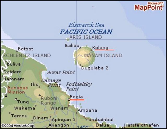 |
Figure 12. Geography of the area around Manam showing two named villages on the island and numerous settlements on the main island of New Guinea. For scale, Manam Island is ~ 10 km in diameter. The volcano is sometimes referred to as Mount Iabu in the regional press. The city of Wewak lies off the map, ~ 160 km W of Manam; the city of Madang lies ~ 150 km to the E. The large meandering river at left is the Sepik. The island's residents, a total of 9,467 people, rely on subsistence farming and fishing for food, and copra and cocoa as a source of income. Map courtesy of Jorgen Aabech. |
The government of Papua New Guinea presented a new website, The National Disaster Center, which broadly disseminates government disaster information including volcano reports and updates (see URL under Information Contacts, below). The website contained a Manam hazards map. Other documents on that site noted shifting winds and the lack of a clearly safe area on the island during the late 2004 crisis. It said that the government would sponsor large-scale evacuations beginning on 27 November 2004.
The eruptive episode that began on 24 October continued at least a week (figure 13). By 31 October, the eruption at Main Crater consisted of Strombolian activity, with ash and scoria emissions. Tephra of ~ 1 cm diameter were deposited in Warisi village on the SE side of the island. Small pyroclastic flows were generated, and fresh lava flowed into the NE radial valley. The lava flow followed the Boakure side of the valley, covering older flows from the 1992-1994 eruption. Beginning on the morning of the 31st, the amount of continuous volcanic tremor increased to moderate-to-high levels, so the Alert Level was increased from Stage 1 to Stage 2. Villagers were advised to remain away from Manam's four main radial valleys.
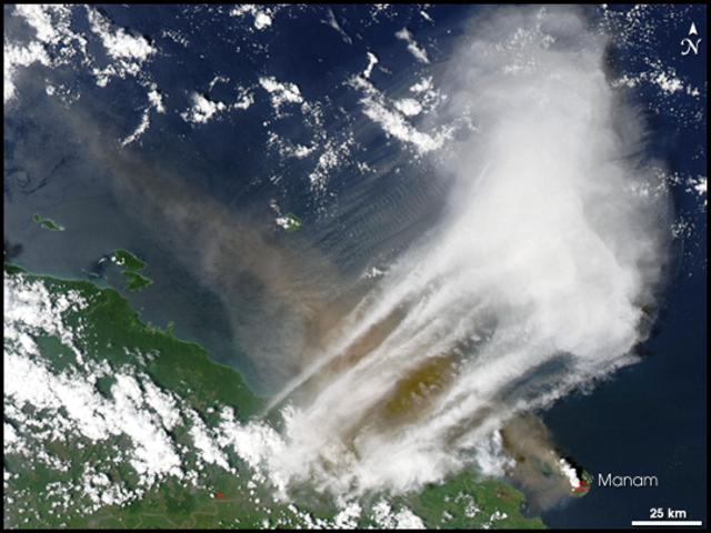 |
Figure 13. Image of Manam and vicinity acquired on 24 October 2004 by the Moderate Resolution Imaging Spectroradiometer (MODIS), an instrument on the Terra satellite of the National Aeronautics and Space Administration (NASA). Dark ash rising from Manam drifted NW along and then away from the N coast of the main island, New Guinea. Courtesy NASA Earth Observatory. |
The Darwin Volcanic Ash Advisory Center reported the 24 October outburst (BGVN 29:11). On 31 October during 0813-1449 they noted a plume at ~ 13.7 km altitude drifting SE on visible satellite imagery. The Aviation Color Code was at Red, the highest level.
According to a news report, ". . . [~ 0.3 m] of ash with hot pumice" landed on the roofs of houses, and ash drifted as far W as Wewak, ~ 100 km away. Reportedly, ~ 4,000 villagers moved to safer areas.
On 2 November around 2325 a possible eruption may have produced a plume to ~ 7.6 km altitude, which drifted SE. Ash was visible on satellite imagery on 8 and 9 November at an altitude of ~ 3 km; on 9 November the plume extended, ~ 55 km to the NE.
A Strombolian eruption occurred during 10-11 November 2004. The ash column from the eruption was estimated to have risen ~ 5-6 km above the crater, and perhaps rose as high as ~ 9 km above the crater, according to an Air Niugini pilot. The activity was accompanied by continuous weak to moderate roaring and rumbling noises and frequent loud explosions. Light ash and scoria fall was reported near local villages. As of 2130 on 10 November ash reached 7 km altitude and 147 km to the SW. As of 12 November, the ash emissions reached 10 km altitude and extended laterally 74 km W to NW of the volcano.
During this reporting interval Darwin VAAC noted that a SE-drifting plume was visible on satellite imagery on 31 October during 0813-1449 at an altitude of ~ 13.7 km.
A satellite image from the Terra Moderate Resolution Imaging Spectroradiometer (MODIS) on 15 November shows a large brown ash plume blowing SW (figure 14).
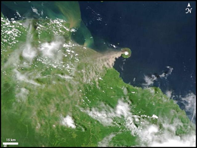 |
Figure 14. Manam image acquired 15 November 2004 from Moderate Resolution Imaging Spectroradiometer (MODIS) passing overhead on the National Aviation and Space Agency (NASA) Terra satellite. Dark ash rises from Manam and drifts SW over New Guinea. Courtesy NASA Earth Observatory. |
According to RVO scientists, on 23-24 November Main Crater ejected glowing lava and discharged an ash cloud that rose ~ 10 km high. A lava flow was also reported to be heading for two villages on the island. At 1850 on 23 November, a phase of strong Strombolian eruption began producing a continuous, thick ash column that rose about 10 km above the summit. The ash cloud emissions were accompanied by projection of glowing lava fragments, loud roaring and rumbling noises, and occasional loud and banging noises that produced shock waves. A continuous bright red glow visible down the NE valley indicated emplacement of a lava flow.
The lava flow was reported heading NE towards villages of Kolang and Bokure 1. In addition to the lava, Manam emitted large rocks. Around this time the aviation red alert issued for aircraft noted that the ash plume extended 130 km SE of Manam.
Press accounts stated that emergency officials said an area was being cleared on the mainland for a possible full-scale evacuation of Manam's ~ 9,500 islanders. Evacuation was to become compulsory if activity intensified from Stage 3 (which was set by 22 November) to Stage 4. Some 20 bush homes had collapsed due to 'mud rain' (presumably, falling tephra), and five people had been injured.
RVO reported that a slight increase in eruptive activity from Main Crater began after 1600 on 26 November, which continued until 0800 on the 29th. Summit activity consisted of continuous forceful emission of thick dark gray ash clouds that rose less than 1 km above the summit before being blown NW. Fine ashfall to the NW at Zogari and Iassa villages was reported from about 1700. A single weak roar was heard between 0600 and 0700 on the 27th.
Seismicity was moderate to moderate-high at 2300 on the 26th and 0800 on the 27th. Volcanic tremors continued to be recorded suggesting the system remained dynamic and capable of ongoing variable eruptions, with sporadic more vigorous phases.
On 28-29 November, RVO reported that ash clouds were rising less than 1 km above the summit before being blown by the shifting NNE and NNW winds. Fine ashfall was reported at Warisi. Weak roaring noises were heard between 1900-2400 on the 28th. A weak glow with weak projections of incandescent lava fragments was visible during the night of the 28th, and Southern Crater released thin white vapor only.
Some press reports described 7,900 persons evacuated from Manam. According to the Planet Diary web site, about 9,000 people were evacuated by 1 December 2004 as the eruption grew more violent.
Mid-afternoon on 5 December RVO noted a slight change in activity at Southern Crater marked by commencement of sub-continuous weak to moderate roaring and rumbling noises. The noises continued until 1000 that day. As darkness fell, intervals of visibility occurred (eg., during 1800-1808, 2030-2108, and 2130-2200); observers saw sub-continuous lava fountaining. Meanwhile, from Main Crater there came a series of sub-continuous, forceful, moderately thick, gray-brown ash-laden clouds, which were occasionally visible above the weather clouds. The ash plume rose between about 600 and 900 m above the summit and drifted to the E and NE. Light ashfall and fine scoria fell at the villages Abaria and Bokure 1. Fluctuating audible noises consisted of low roars, 'jet engine' roars, and occasional still-louder roars. Although visibility was generally poor due to volcanic ash clouds from both craters, observers could still make out variable glow coming from the craters.
On 8 December 2004, The National reported that, according to RVO, Manam erupted starting on the morning of 6 December. Fist-sized scoria were thrown out of the vent into the air, hitting houses in the villages below. The eruption began at 0800 and peaked at 1150 with "seismicity continuing."
The National also reported that a pyroclastic flow occurred in the SE valley during the 6 December eruption, with ash and cloud directed NW. On the 6th, residents of Madang (~ 150 km E of Manam) described feeling tremor or ground motion; those in Wewak (~ 160 km to the W) reported similar sensations and also noted volcanically derived dust. Although ash from 6 December was apparently widespread, Googling for news of Manam ash in Irian Jaya failed to turn up any reports from there.
The Darwin VAAC reported ash plume sightings from satellites during 12-14 December, and the RVO reported moderate eruptions continuing in that period.
Fatalities. An article by Bonney Bonsella in The National showed pictures of Manam Islanders in evacuation. They waded through shallow surf to board through the open bow of a large beached landing craft. The article discussed fatalities during the eruption.
"The volcanic eruption on Manam Island in the Madang province has so far claimed five lives—two elderly women and three children between the ages of 5-13. The coordinator of the Manam evacuation exercise Camillus Dugumi confirmed the deaths, adding that the deaths were linked to respiratory complications resulting from inhaling volcanic ashes and dust. Mr Dugumi, who is also the district health programme manager, said one of the deaths was that of an elderly women from Bokure village recorded early last week at the Bogia District hospital. The women died after being admitted to the hospital for respiratory complications. One child, a little boy, died on Friday at the Asuramba care centre after suffering pneumonia."
"Three others—an adult women and two other children—had died during earlier volcanic activity on Manam."
Displaced residents. The above-mentioned article related that three State-owned plantations (called Asuramba, Potsdam, and Magem (and Daigul?)) were set aside, ". . . at least for the time being[,] to accommodate a speedy resettlement of the displaced Manam islanders." Another news article noted that these plantations are near the town of Bogia (figure 4). The National Disaster Center website noted that "The three plantations were bought off from the lessee in 1995 for K1.25 million following a National Executive Council decision for the purpose of resettlement of Manam Islanders displaced by volcanic activity." Controversies remain with respect to land issues. Still, that website noted that the long-term solution advocated by the President, Manam Local Level Government is to resettle the people of Manam on the mainland. For this purpose the Provincial Disaster Committee has identified State land to resettle the Manam Island people.
MODVOLC. The MODIS infrared instrument flown on the NASA Terra and Aqua satellites showed an impressive set of thermal alerts beginning 21 October 2004 (figure 15). Since the beginning of MODVOLC operations (BGVN 28:01) thermal alerts occurred at Manam during only two periods. The first, 7 April-21 May 2002, was related to increased Strombolian activity (BGVN 27:05). The second period, 21 October until at least 14 December 2004, was associated with the current crisis and was a time when alert ratios and summed radiances reached higher values than during the first period. These parameters are consistent with a highly active vent and/or lava flows, and in accord with vigorous Strombolian emissions seen in the field.
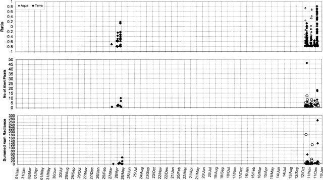 |
Figure 15. MODVOLC thermal alert ratios, number of alert pixels, and summed 4 mm radiance plots for Manam from 1 January 2001 until 31 December 2004. Alerts occurred only between 7 April and 21 May 2002 and between 21 October and 14 December 2004. Thermal alerts collated by Charlotte Saunders, and David Rothery; data courtesy of the Hawaii Institute of Geophysics and Planetology's MODIS thermal alert team. |
This analysis of MODIS thermal alerts (using the MODVOLC alert-detection algorithm) is based on data extracted from the MODIS Thermal Alerts website maintained by the University of Hawaii HIGP MODIS Thermal Alerts team.
Thermal alerts are based on an 'alert ratio,' and an alert is triggered whenever this ratio has a value more positive than -0.8. This threshold value was chosen empirically by inspection of images containing known volcanic sites at high temperature, and is the most negative value that avoids numerous false alarms. There are also some day-time alerts, which are based on the same algorithm but incorporating a correction for estimated solar reflection and a more stringent threshold whereby the alert ratio is required to be more positive than -0.6 in order to trigger an alert.
Information Contacts: Rabaul Volcano Observatory (RVO), P.O. Box 386, Rabaul, Papua New Guinea; National Disaster Centre, Department of Provincial Affairs and Local Level Government (Ministry of Inter-Government Relations), PO Box 4970, Boroko, National Capital District, Papua New Guinea (URL: http://www.pngndc.gov.pg/); David Innes, Flight Safety Office, Air Niugini; Andrew Tupper, Darwin Volcanic Ash Advisory Centre, Australian Bureau of Meteorology (URL: http://www.bom.gov.au/info/vaac); Jorgen Aabech, Skogbrynet 40B, N-1709 Sarpsborg, Norway (URL: http://www.vulkaner.no/); MODIS Thermal Alert System, Hawaii Institute of Geophysics and Planetology (HIGP), School of Ocean and Earth Science and Technology, University of Hawaii at Manoa (URL: http://modis.higp.hawaii.edu/); David Rothery and Charlotte Saunders, Department of Earth Sciences, The Open University, Milton Keynes, MK7 6AA, United Kingdom; Kevin Pamba and Bonney Bonsella, The National (URL: http://www.thenational.com.pg/).
One death, 14 injuries due to 27 January eruption; stratospheric injection
On 24 October 2004 a strong eruption occurred at Manam (BGVN 29:10). Several more significant eruptions followed in late 2004 (BGVN 29:11), leading to the most severe and damaging one, which took place on 27 January 2005. That event occurred in conditions favorable to satellite imagery, enabling Andrew Tupper of the Darwin Volcanic Ash Advisory Centre (VAAC), and colleagues, to confirm that the associated ash cloud reached to over 20 km altitude, well into the stratosphere.
Satellite remote sensing documented 5 eruption plumes ascending to over 15 km during this issue's reporting interval, 23 October 2004-28 January 2005. One additional plume may have been missed by remote sensing in adverse weather conditions. Various images from the 2004 and 2005 eruptions are on the Darwin VAAC website (see Information Contacts, below). Sulfur dioxide is discussed there as well as on websites of the OMI-TOMS Volcanic Emissions Group and related sites.
The Bulletin has benefitted from reports by the Rabaul Volcano Observatory (RVO), the media, and the Darwin VAAC. Although the 27 January eruption received comparatively little press coverage, it caused several injuries and one death. RVO staff working at Manam faced challenging, hazardous conditions. The island had been home to ~ 9,500 now-displaced residents.
Summary of RVO observations. During the reporting interval both lava flows and pyroclastic flows reached the sea at various times (BGVN 29:10 and 29:11). The main pathways were the NE and SE valleys (table 2, figures 16 and 17). Intervals of tremor were common.
Table 2. A summary of RVO observations involving lava flows and pyroclastic flows associated with Manam's eruptions during 23 October 2004-28 January 2005. Andrew Tupper (of the Darwin VAAC) compiled this list from available RVO reports and communications with RVO staff.
| Date | Event Description |
| 24 Oct 2004 | Pyroclastic flows reached the sea and lava flowed 600 m down the SE valley. |
| 31 Oct 2004 | Three-lobed lava flow in NE valley, and possibly a small flow in the NW valley. |
| 11 Nov 2004 | Lava in NE valley. |
| 23-24 Nov 2004 | Lava in NE valley. "The flow that headed towards Bokure 1 terminated about 100 m away from the main road . . . the Kolang lava flow had reached the sea" (reported by Warisi observer Herman Tibong). Ash on roofs caused a number of houses to collapse. |
| 19-20 Dec 2004 | Lava and pyroclastic flows in SE valley. Pyroclastic flows stopped 200 m from the sea on the 19th (no report on what happened on the 20th). |
| 27-28 Jan 2005 | 14 injured and 1 dead at Warisi; debris voluminous and widespread on the island; ashfall reported ~230 km W of Manam. |
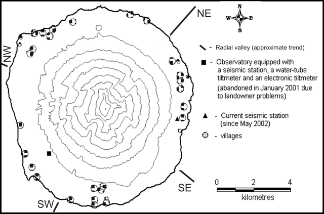 |
Figure 16. Map of Manam island made or updated circa 2002 (contour interval, 200 m). A temporary observatory was at Warisi (triangle, 'current seismic station') on the island's E side, but the eruption on 27 January 2005 destroyed it. Approximate trends of radial valleys were added by Bulletin editors. Courtesy of RVO. |
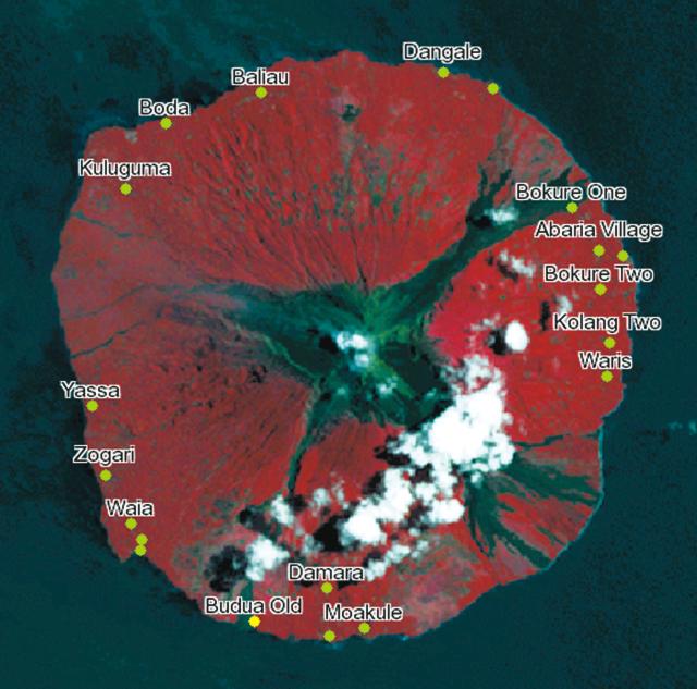 |
Figure 17. Annotated image of Manam indicating village and other place names on a false-color satellite photo (note the cloud cover; for scale, compare to previous figure). Source details are unknown. "Waris," is more commonly spelled "Warisi" in RVO reports. Courtesy of the PNG Mapserver website. |
Eruption on 27 January 2005. RVO reported that eruptive activity during the evening of 27 January was more severe than previous eruptions of the current eruptive period. As indicated on table 1, during 27-28 January there were 14 people injured and one person killed at Warisi village. RVO's monitoring base at Warisi was completely destroyed, taking out its HF radio, seismograph, and a satellite phone, thus preventing RVO from providing information on the current level of activity. The phone had been donated by an airline just a few weeks prior, provided as a means of aiding eruption-warning efforts. The station sat on the E flank at Warisi village (figures 1 and 2). RVO later recovered the station's seismograph and installed it on the island's NW side; they also restored radio communications.
According to the Papua New Guinea (PNG) news source,The National, some people had returned on 27 January from the displacement camps on the mainland to gather food from their island gardens, only to have their boat destroyed by impacts from erupted rocks. The National also reported that many of the residents of the island who were originally evacuated in November 2004 had returned. There were reports of several houses that had burned down from hot emissions and others that collapsed under the weight of ash and pyroclastic material. It was reported that after the large eruption on 27 January, local authorities planned to evacuate about 2,000 residents.
Ash fell at ~ 230 km W of Manam (in Ambunti district, East Sepik province, PNG). Tupper recognized NW monsoon winds that took low-level ash SE. Thus, the ash that fell in Ambunti must have traveled at a higher altitude, which Tupper estimated to be above 6 km altitude.
The October-January eruptive sequence. Figure 18 plots eruption heights versus time during 23 October 2004 to late January 2005. Three kinds of eruption-height estimates appear: those from pilot reports, RVO's estimates (ground-based observations), and Tupper's post-analysis studies of satellite data. In a descussion below, Tupper mentions the differences between the three height-estimate techniques. The line showing alert level corresponds to the right-hand scale. Six eruptive clouds are clear on the graph.
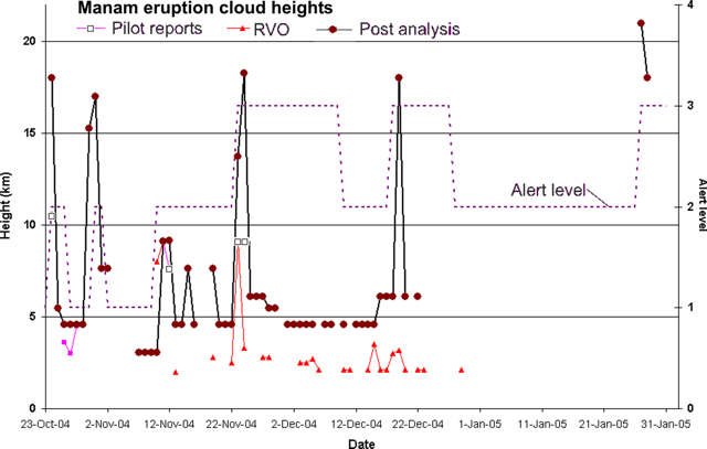 |
Figure 18. A graph of Manam's cloud heights from 23 October 2004 to late-January 2005, as determined from various means (see key along top). The dashed line corresponds to the right-hand scale of the graph, which displays alert levels reported by RVO (0-4, with 4 as the highest). Courtesy of Andrew Tupper, Darwin VAAC. |
The 24 October eruption at Manam occurred just before the Terra and Aqua satellites passed over. The data from those satellites, and from AVHRR and GOES satellites, indicated a very ice-rich cloud. Associated with Manam's eruption on 24 October, the coldest temperature measured from the high-level cloud was about 204 K (a couple of hours after the eruption), which translated to an altitude of about 15-18 km (a height supported by the ash cloud's subsequent dispersion, including wind trajectories consistent with the ~ 18 km altitude plotted on figure 3). There was no evidence of significant stratospheric penetration. Pilot reports for the cloud's top were generally lower, as is usual for large eruptions (Tupper and Kinoshita, 2003).
Figure 19 presents a photo of the 11 November eruption plume as seen by Air Niugini pilot David Innes. He estimated the visible portion of the plume height at "30,000 feet" (~ 9 km), but the cloud probably ascended at least a bit higher as it entered into masking cirrus clouds from a tropical disturbance to the N, so the pilot's estimate might be stated as 'above 9 km.' RVO's ground observer estimated a plume at ~ 8 km slightly earlier in the eruption, on about 10 November. The satellite-based analysis was thwarted by the cirrus cloud cover during this eruption.
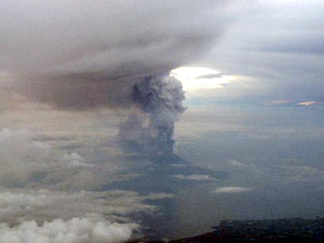 |
Figure 19. A N-looking aerial photo showing Manam's plume at 0630 local time on 11 November 2004. The plume extends to ~9 km before disappearing into higher weather clouds. Photo by David Innes of Air Niugini; used here with his permission. |
From 20 December until just before the 27 January eruption, no plumes or hot spots were visible. Few plumes were reported by RVO, and none were seen by pilots (table 2). The 27 January eruption began about 1400 UTC; and an Aqua/MODIS image from 0507 UTC is shown as figure 20.
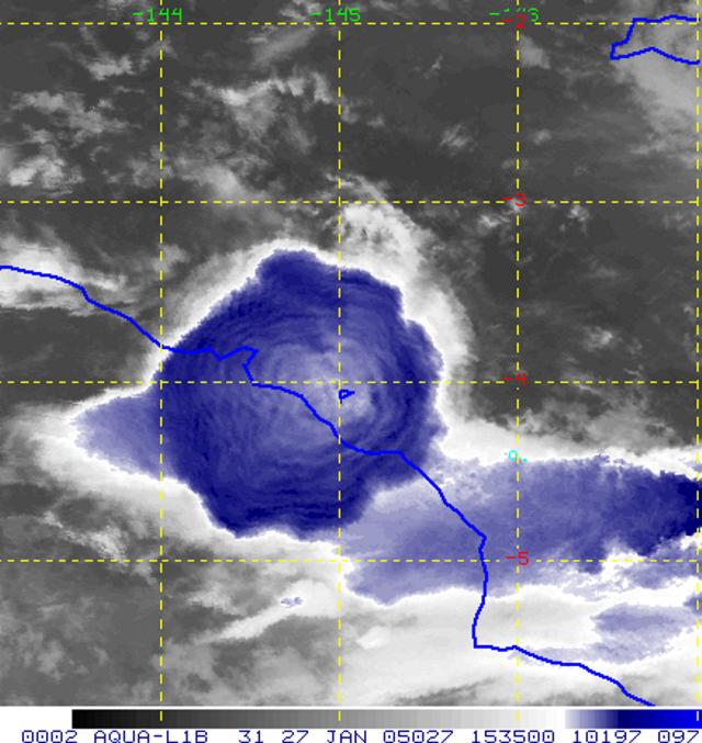 |
Figure 20. An infrared Aqua/MODIS image of the umbrella cloud from the 27 January 2005 Manam eruption (taken at 1535 UTC on the night of the 27th). The image is enhanced to show the 'warm spot' in the centre of the cloud (warm because of the stratospheric intrusion) and the gravity waves in the cloud. The lobate structure at the fringes of the cloud is similar to other observed umbrella clouds, such as the 1991 Pinatubo cloud. At this stage the cloud had a diameter of approximately 180 km. Courtesy of Andrew Tupper. |
The Darwin VAAC initially estimated the 27 January eruption cloud's maximum height as 21 km altitude, but later analysis found the range 21-24 km a better estimate. Infrared 11-µm imagery from GOES-9 at 1440 UTC and Aqua/MODIS at 1539 UTC on 27 January showed 'warm' spots in the middle of the umbrella cloud of 215.4 K and 210.4 K, respectively, indicating a substantial overshoot of the cloud top into the warmer stratosphere (tropopause temperatures were around 187 K). The GOES-9 temperature may be less useful because of poorer satellite resolution and calibration, and because at that stage the cloud may not have come into equilibrium with its environment. Comparing these temperatures to a temperature sonde taken from nearby Manus Island at 0000 UTC on 28 January suggests a cloud altitude of 21-24 km. Tupper plotted the more conservative (smaller) value on figure 3.
The 27 January eruption cloud was extremely difficult to track, as it was ice-rich and mixed with monsoonal storms, but dispersion models and satellite analysis suggest that a mid-tropospheric portion spread quite quickly W over Irian Jaya, while higher cloud remained near the eruption site for some time. The best 'tracer' for the cloud in operations turned out to be the strong 'ice' signature in split-window imagery similar to the Hekla (Iceland) eruption in the year 2000.
Another large eruption occurred around 2300 on 28 January. That plume's height plots at 18 km altitude (figure 3).
Preliminary synopsis. Tupper wrote that he and his group were aware of five or six major events "during these [Manam] eruptions that have generated high (over 10 km altitude) eruption clouds—23-24 October 2004, 31 October 2004, 10-11 November 2004, 23-24 November 2004, 19-20 December 2004, and 27-28 January 2005 [figure 3]. On each of these occasions a high and sometimes persistent cloud has developed over a stronger phase of the eruption. The largest event by far has been the 27-28 January event, which was the only one to clearly penetrate into the stratosphere.
"Attached is a graph [figure 3] showing the heights reported by ground observers, by local pilots, and derived from satellite analysis. Some major differences of perspective are evident. I believe that, in general, the ground observer heights are most accurate for the lower eruptions, pilot reports can be accurate or quite inaccurate depending on the pilot and the viewing angle, and satellite estimates are most accurate for the larger eruptions.
"The cold-point tropopause generally occurs at around 16-18 km at this time of year in Papua New Guinea, and scores of thunderstorms reach these altitudes every day in the area. Consequently, it is not surprising that the larger eruptions are easily able to reach these altitudes. The tropopause is also the major dynamical limit on the rise of the larger eruption clouds. The eruption of 27 January clearly penetrated into the stratosphere, to altitudes of 21-24 km, based on the warmth of the central umbrella cloud, and the subsequent dispersion of the ice-cloud, and the SO2 from the eruption."
"All of the eruption clouds have been water/ice rich, and difficult to track using satellite techniques. The ash signal at altitudes above the freezing level has been overwhelmed by the ice signal in infrared split-window imagery. Similarly, in visible and true-colour imagery, even where the lower level clouds have shown an ash signal, the higher clouds have been a brilliant white and have only been revealed as volcanic in short-wave infrared (3.7 µm) imagery and with SO2 retrievals. For example, [in BGVN 29:11 (the first of two satellite photos)] the large brilliant white cloud to the N of Manam (overlying the dark ash cloud) derives from the same 24 October eruption."
References. Tupper, A., and Kinoshita, K., 2003, Satellite, air and ground observations of volcanic clouds over island of the Southwest Pacific: South Pacific Study, v. 23, no. 2, p. 21-46.
Information Contacts: Andrew Tupper, Darwin Volcanic Ash Advisory Centre, Australian Bureau of Meteorology (URL: http://www.bom.gov.au/info/vaac); Rabaul Volcano Observatory (RVO), P.O. Box 386, Rabaul, Papua New Guinea; National Disaster Centre, Department of Provincial Affairs and Local Level Government (Ministry of Inter-Government Relations), PO Box 4970, Boroko, National Capital District, Papua New Guinea (URL: http://www.pngndc.gov.pg/); The National Online, Lot 13 Section 38, Waigani Drive Hohola, PO Box 6817 Boroko, National Capital District, Papua New Guinea (URL: http://www.thenational.com.pg/); Papua New Guinea Mapserver (Mapu), EDF 8/9 EU-SOPAC Reducing Vulnerability of Pacific ACP States Project; David Innes, Flight Safety Office, Air Niugini, P.O.Box 7186, Boroko, Port Moresby, National Capital District, Papua New Guinea (URL: http://www.airniugini.com.pg/); Simon Carn, TOMS Volcanic Emissions Group, University of Maryland, 1000 Hilltop Circle, Baltimore, MD 21250, USA (URL: https://so2.gsfc.nasa.gov/).
Aircraft encounters airborne gas from 27 January 2005 eruption; infrasonics
Manam erupted several times during October to December 2004 and January 2005. A strong eruption on 24 October 2004, preceded by a buildup in seismicity and a felt earthquake, was described in BGVN 29:10. This eruption generated pyroclastic flows, and its plume was imaged from space. The eruption sent ash and condensed water in the form of ice to a maximum height of ~ 15 km altitude. On 10-11 November 2004, a Strombolian eruption occurred; the ash column was estimated to have risen ~ 5-6 km above the crater. On 23-24 November 2004 Manam's main crater ejected glowing lava and discharged an ash cloud that rose ~ 10 km high. A lava flow was also reported to be heading for two villages on the island. Details and reports of eruptions in November and December 2004 were included in BGVN 29:11.
The eruption at Manam on the evening of 27 January 2005 (BGVN 30:02) was more severe than the previous ones during the current eruptive period. During 27-28 January 2005 there were 14 people injured and one person killed at Warisi village. The reports of the Rabaul Volcano Observatory (RVO) and the Darwin VAAC, and an analysis of the Manam eruption clouds by Andrew Tupper of the Darwin VAAC, were summarized in BGVN 30:02. In late January, five commercial flights were cancelled from Rabaul, East New Britain, delaying about 100 passengers.
Documented occurrence of olfactory fatigue. A report received from Andrew Tupper discussed an encounter of an aircraft with an airborne gas plume that took place about 2300 UTC on 29 January (0800 on the 30th, East Timor time) reported to him by a pilot. The encounter took place at a considerable distance from Manam, and a map is helpful to visualize the region's geography (figure 21). The incident involved entry into a visibly anomalous, hazy-blue cloud that turned out to contain sulfurous odor (figure 22). Although Tupper and the pilot discussed other possibilities for the cloud's origin, Tupper came to the conclusion that the cloud was volcanic fog (vog) erupted from Manam.
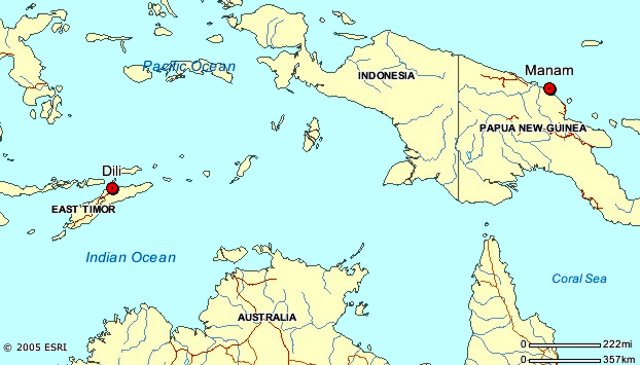 |
Figure 21. The airport at Dili, East Timor (Indonesia), located about 2,200 km WSW of Manam. |
Key portions of the pilot's message conveyed to us by Tupper follow.
"On descent into Dili, approaching 10,000 feet at 12 nautical miles [~ 3 km altitude and ~ 22 km from the airport] aircraft control levers were pulled back to flight idle just prior to entering a thin layer of smooth stratus cloud [figure 22].
 |
Figure 22. The hazy blue cloud that produced a sulfur smell in the cockpit of the plane approaching Dili. The photo was taken by the air crew (names not given). |
"Shortly after passing into the cloud, a strange smell was soon noticed in the cockpit; once the accusations of responsibility had passed, it quickly became apparent that the smell was not the result of a bodily function. The smell became very strong, with high sulfur content. As a precaution the Captain directed the First Officer to don his oxygen mask. The smell persisted but began to weaken on descent, and landing was accomplished without incident. After landing, First Officer removed the oxygen mask and noted the smell had remained. The captain had by this time become desensitized to the smell. Upon shutdown, unloading was halted, until such time as the cargo hold could be examined for a source of the smell. No smell remained."
Tupper and the pilot discussed possible sources for the smell. The cloud displayed a distinct blue haze (Tupper commented that "it's difficult to tell from the attached photo whether the blue is all that out-of-the-ordinary, but obviously they thought it interesting enough to take a photo!"). The cloud sat on the hills and appeared to have fog-like characteristics. The pilot described the odor as sharper and more metallic than the smell of H2S (a description consistent with SO2, the odor of which is sometimes described as metallic or akin to a struck-match.
What caused the sulfurous-smelling stratus cloud? The sulfur content may have come from either nearby volcanoes, none of which have been reported as active, or from industrial production (possibly Kupang). Due to a serious dengue outbreak in East Timor, it may have been the result of chemical mosquito control. Many chemical methods of mosquito control are based on sulfur products. Malathion is one such product; it contains mercaptan, which has a strong noxious odor. (Organic compounds with HS bound to carbon are called mercaptans or thiols and those of low molecular weight have strong smells. Small doses of mercaptan are often used to give natural gas a distinctive odor.) One possible way to explain the sulfurous gases was morning fog moving up the hills of Dili in response to anabatic (upslope-blowing) winds, which also carried residual insecticide.
Tupper spoke to or emailed the pilot several more times to get the following other details. The aircraft was an Embraer E120, a 30 seat turbo prop, with 20-25 people on board. The cabin attendant also noticed the smell, but no passengers commented. Despite the speculation about chemicals above, this was the only trip on which the smells had been noticed by the pilot.
According to Claire Witham, human perception of SO2 odor varies depending on the individual's sensitivity, but SO2 is generally perceived between 0.3-1.4 ppm and is easily noticeable at 3 ppm. This is generally below the level where health effects (e.g. respiratory response) might be noted. In general an exposure limit of 1-5 ppm is the threshold for respiratory response in healthy individuals upon exercise or deep breathing, whilst at 3-5 ppm the gas is easily noticeable and may cause a fall in lung function in persons at rest, and increased airway resistance. Asthmatic individuals may respond at much lower concentrations, and prolonged exposure to low concentrations carries increased risk for those with pre-existing heart and lung diseases. A more detailed review of gas hazards and guidelines has just gone online on the International Volcanic Health Hazard Network.
Significant in this event is that the flight crew thought that the smell had dissipated. The First Officer, who was wearing an oxygen mask, remained able to detect that the smell persisted. This indicates that the others in the crew lost their ability recognize that the sulfurous odors remained, a well-know effect of sulfurous gases called olfactory fatigue ('bombarded nerve receptors'), a potentially confusing situation for pilots focused on escaping from a volcanic plume (Wunderman, 2004).
Tupper conducted dispersion modeling of the 27 January 2005 Manam eruption (figure 23). The results suggested that the SO2 cloud from the volcano probably passed over East Timor on the night before the incident and at higher altitudes. This is supported to a limited extent by the preliminary ozone and SO2 monitoring results (figure 24), which suggest that the bulk of the cloud went N, but that part of the cloud traveled over the Banda Sea and passed over East Timor. The low level winds are highly unlikely to have carried the SO2 to East Timor, but there was significant storm activity on the night when the cloud would have passed over. Excluding other explanations on the grounds that the eruption / encounter timing are unlikely to be mere coincidence, the most likely explanation for the flight crew's experience is that some eruption products from Manam were rained out over East Timor on the night of 29 January 2005. If SO2 had been incorporated into ice particles, which then rained out, the particles would have melted and released SO2 at about the level of the encounter, where the temperature was a bit above freezing. According to this scenario, the plane then flew through the resultant vog/stratus the next morning.
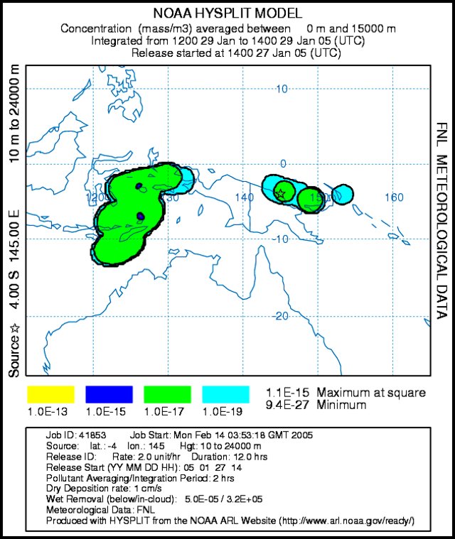 |
Figure 23. An ash dispersion model for the eruption cloud associated with the eruption of Manam on 27 January 2005. The model takes into account wind at various altitudes and other meteorological data, and predicts the movement of material injected in the atmosphere. The model used, NOAA hysplit, adopted the boundary condition that material was above the volcano between 10 and 24 km altitude starting at 1400 on 27 January. The results shown predict the dispersal for the interval 1200-1400 on 29 January. The model indicates that some material from Manam's 27 January eruption traveled WSW to where the aircraft-gas plume encounter took place. The model is a product of the NOAA Air Resources Lab with this particular run provided by Andrew Tupper. |
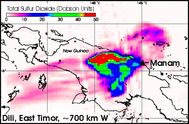 |
Figure 24. A satellite image of atmospheric SO2 burden from Manam made about 12 hours after the 27-28 January 2005 eruption. The image resulted from the NASA Ozone Monitoring Instrument (OMI), which flew over the region on NASA's new Aura satellite. This image was produced from preliminary, uncalibrated data provided by the OMI. The OMI detected a large cloud of SO2 drifting W over the island of New Guinea. The gas is measured in Dobson Units (DU), a reflection of the number of molecules in a square centimeter of the atmosphere. Darker pixels cover the areas of highest concentration, while the lowest concentrations are represented by lighter ones (red and pink, respectively, on the colored electronic version of the Bulletin). If you were to compress all of the SO2 in a column of the atmosphere into a flat layer at standard temperature and pressure, one Dobson Unit would be 0.01 mm (millimeters) thick and would contain 0.0285 grams of SO2 per m2. On January 28, the atmosphere over New Guinea contained up to 50 Dobson Units (red regions), or 1.425 grams of SO2 per square meter. NASA image and caption courtesy Simon Carn, Joint Center for Earth Systems Technology. |
Infrasound reports. The Comprehensive Nuclear Test Ban Treaty Organisation (CTBTO) is installing a world-wide network of 60 infrasound stations as part of the International Monitoring System (IMS) for detection of nuclear tests. The stations, some of which are already functioning, use microbarographs (acoustic pressure sensors) to detect very low-frequency (0.01-10 Hz) sound waves in the atmosphere produced by natural and anthropogenic events.
The eruption at Manam on 27 January at about 1400 UTC was detected at several infrasound stations around the Pacific (table 3). In one case a signal was received at a distance exceeding 10,000 km. The sound of the explosion took more than ten hours to reach that most distant station, located in Washington state (USA). The difference in the calculated and measured signal azimuths is likely caused by high atmosphere winds, and is reasonable given the great distances that the signal traveled.
Table 3. Arrival times and great circle paths for infrasound signal from Manam eruption on 27 January 2005 received at CTBTO infrasound stations. Azimuth and Distance data are for the calculated great circle path from the station to the volcano. Courtesy of Robert North.
| CTBTO Infrasound Station | Azimuth (°E of N) | Distance (km) | Measured signal azimuth (°E of N) | Date | Arrival time |
| I07AU Warramunga, Central Australia | 35 | 2079 | 32 | 27 Jan 2005 | 16:00 UTC |
| I22FR New Caledonia | 311 | 3091 | -- | -- | -- |
| I05AU Tasmania, Australia | 356 | 4270 | 350 | 27 Jan 2005 | 18:30 UTC |
| I55US Windless Bight, Antarctica | 336 | 8303 | 335 | 27 Jan 2005 | 22:07 UTC |
| I53US Fairbanks, Alaska | 247 | 9358 | 252 | 27 Jan 2005 | 23:12 UTC |
| I56US Newport, Washington | 273 | 10920 | 276 | 28 Jan 2005 | 00:34 UTC |
Subsequent RVO observations. Although it remained active, Manam calmed considerably during February-May 2005. During the first two weeks of February 2005, emissions from Manam continued. On 15 February 2005, the alert level was reduced from 3 to 2. Mild eruptive activity was observed from Manam's Southern crater during the third week of February. Weak-to-moderate ash explosions rose a few hundred meters above the crater and drifted E and SE, depositing fine ash in areas downwind. Throughout February, seismicity was at low levels, with small low-frequency earthquakes occurring and no volcanic tremor. Throughout March, weak-to-moderate emissions from both the Main and Southern craters continued to produce occasional ash clouds during most days. On 15 March, a thin plume from Manam was visible on satellite imagery. On 24 March, emissions from Main crater rose to ~ 1 km above the summit. On 28 March, a moderate explosion produced an ash plume to a height of ~ 1.2 km above the summit. Ash plumes drifted N, depositing ash on the island. Seismic activity fluctuated between low and moderate, with low-frequency earthquakes recorded.
During April and May 2005, mild eruptive activity continued at the volcano. Manam remained at alert level 2 from February 2005 through at least late May. A thin plume extending 55 km NW on 4 May was seen on satellite imagery by the Darwin VAAC. The ash cloud remained below 3 km altitude.
Reference. Wunderman, R., 2004, Sulfurous odors: A signal of entry into an ash plume—perhaps less reliable for escape, Second International Conference on Volcanic Ash and Aviation Safety (Alexandria, Virginia, USA), 21-24 June 2004 (Plenary Session 1: Encounters, Damage, and Socioeconomic Consequences, poster P 1.2, Socioeconomic consequences) (http://www.ofcm.gov/ICVAAS/Proceedings2004/ICVAAS2004-Proceedings.htm).
Information Contacts: Andrew Tupper, Darwin Volcanic Ash Advisory Centre, Australian Bureau of Meteorology (URL: http://www.bom.gov.au/info/vaac); Rabaul Volcano Observatory (RVO), P.O. Box 386, Rabaul, Papua New Guinea; David Innes, Flight Safety Office, Air Niugini, PO Box 7186, Boroko, Port Moresby, National Capital District, Papua New Guinea (URL: http://www.airniugini.com.pg/); International Volcanic Health Hazard Network (URL: http://www.ivhhn.org/); Simon Carn, TOMS Volcanic Emissions Group, Univ. of Maryland, 1000 Hilltop Circle, Baltimore, MD 21250, USA (URL: https://so2.gsfc.nasa.gov/); Claire Witham, Meteorology Office, FitzRoy Road, Exeter, EX1 3PB, UK; Robert North, SAIC Monitoring Systems Division, 1953 Gallows Rd., Vienna, VA 22182, USA; NOAA Air Resources Lab (ARL), Room 3316, 1315 East-West Highway, Silver Spring, MD 20910, USA (URL: http://www.arl.noaa.gov/ready/).
Comparatively mild eruptions with rare minor local ashfall
Manam erupted several times during October-December 2004 and January 2005 (BGVN 29:10, 29:11). The eruption on the evening of 27 January 2005 (BGVN 30:02) was more severe than the previous ones during the current eruption period; there were 14 people injured and one person killed at Warisi village. During April and May 2005, mild eruptive activity continued. Manam remained at Alert Level 2 from February 2005 through late May.
Throughout April 2005, both summit craters released occasional pale gray to brown ash clouds to a few hundred meters above the summit before being blown SW, W, and NW, resulting in fine ashfall. Occasional low rumbling and roaring noises from Southern Crater were heard on 23 April and 29 April. A weak to moderate glow accompanied by projections of incandescent lava fragments was visible on 28 April and 30 April. There were no audible noises and no night-time glow from the Main Crater.
April seismicity was at low-moderate level. Occasional weak volcanic tremors were recorded during the month. The daily number of low frequency earthquakes range between 700 and 1350.
A pilot reported an eruption on 13 June at 0445 UTC. The Darwin Volcanic Ash Advisory Centre (VAAC) reported that ash plumes from Manam were visible on satellite imagery on 16-17 June, 30 June, and 1-2 July. On 19 July ash from Manam was visible extending SW on satellite imagery. Ash was also visible on satellite imagery on 20 July. In all instances, the heights of the plumes were not reported.
According to the Rabaul Volcanological Observatory (RVO), during 15-21 August low-level volcanic activity continued at Manam, and the alert level was reduced to level 1. On 15 August, ash was emitted from Southern Crater. The Darwin VAAC reported that a low-level plume from Manam was visible on satellite imagery on 22 August. Mild eruptive activity continued during 22-28 August, with occasional emissions of weak-to-moderate ash plumes on several days. Ash clouds emitted on 22 and 26 August rose several hundred meters above the volcano's crater and drifted NW, depositing ash in areas between the towns of Jogari and Kuluguma, and beyond to Boisa Island.
During September, the Main Crater continued to release weak emissions of thin white-gray ash clouds. On 17 September, the ash clouds increased slightly in volume and were blown to the NW part of the island. No glow was observed at night and technical problems thwarted seismic recording. Manam remained at Alert Level 1, indicating low levels of activity, through 19 September.
Information Contacts: Ima Itikarai, Rabaul Volcano Observatory (RVO), P.O. Box 386, Rabaul, Papua New Guinea; Andrew Tupper, Darwin Volcanic Ash Advisory Centre (VAAC), Bureau of Meteorology, Northern Territory Regional Office, PO Box 40050, Casuarina, Northern Territory 0811, Australia (URL: http://www.bom.gov.au/info/vaac/).
Evacuees tempted to return; 27 February eruption reached stratosphere
Manam currently represents one of Papua New Guinea's most potent volcanic crises. It erupted several times during October-December 2004 and January 2005 (BGVN 29:10, 29:11). According to the Rabaul Volcano Observatory (RVO), the eruption on the evening of 27 January 2005 (BGVN 30:02) was the most severe activity during the current eruption period; 14 people were injured and one person killed at Warisi village (see villages in plan views of island, BGVN 30:02).
This report discusses the mild outbursts during April-May 2005, and the strong eruption on 27 February 2006. The latter eruption cloud rose into the stratosphere, ascending to a satellite-estimated altitude of 19 km. After a 9 March eruption, the press reported one elderly person missing. An eruption during the reporting interval dropped tephra on a village, forcing 49 residents to flee.
Generally mild behavior during April 2005 through mid-February 2006. Throughout April 2005, both summit craters released occasional pale gray to brown ash clouds to a few hundred meters above the summit before being blown SW, W, and NW, resulting in fine ashfall. Occasional low rumbling and roaring noises from Southern Crater were heard on 23 April and 29 April. A weak-to-moderate glow accompanied by projections of incandescent lava fragments was visible on 28 and 30 April. There were no audible noises and no night-time glow from the Main Crater. During the month, seismicity was at low-moderate levels, and tremor was occasional and weak. The daily number of low-frequency earthquakes ranged between 700 and 1,350.
A pilot reported a Manam eruption on 13 June 2005 at 0445 UTC. In addition, Darwin Volcanic Ash Advisory Centre (VAAC) reported ash plumes visible on satellite imagery during 16-17 June, 30 June, 1-2, 19, and 20 July. Imagery indicated that Manam's 19 July ash extended SW. In all instances, the heights of the plumes were not reported.
According to RVO, on 15 August, ash discharged from Southern Crater; otherwise during 15-21 August, comparatively weak volcanism prevailed and the Alert Level was reduced to Level 1. The Darwin VAAC reported a low-level plume on 22 August imagery. Mild eruptive activity continued during 22-28 August, with occasional emissions of weak-to-moderate ash plumes on several days. The ash clouds emitted on 22 and 26 August rose several hundred meters above the volcano's crater and drifted NW, depositing ash in areas between the towns of Jogari and Kuluguma, and beyond to Boisa Island.
During September weak emissions of diffuse white-gray ash clouds continued from Main Crater. On 17 September, the ash clouds increased slightly in volume and were blown to the NW part of the island. No glow was observed at night and technical problems thwarted seismic recording.
On 1 October, a pilot observed ash from Manam below ~ 3 km altitude extending NW. Ash was not visible on satellite imagery. During 3-9 October RVO reported that ash emissions continued from Main Crater. Ash clouds rose to low levels and drifted NW, depositing ash in downwind areas. RVO learned that ash was visible on satellite imagery at ~ 3 km altitude.
During the last 10 days of October, low-level eruptive activity continued at Manam with plumes visible on satellite imagery extending NW. Manam remained at Alert Level 1, indicating low levels of activity from August 2005 through December 2005.
During January 2006, mild eruptive activity occurred with occasional ash emissions during 1-4 January, and dull incandescence was visible on 1 and 2 January. Gas was emitted from Southern Crater during 1-7 January. Seismicity was at low levels during January 2006.
Large eruption of 27-28 February 2006. A large eruption began on 27 February around 1733 from Manam's Southern Crater. According to Andrew Tupper of the Darwin VAAC, satellite imagery showed an umbrella cloud above the volcano and a strong hot spot. The edges of the ash cloud were ice-rich and the eruption-plume height appeared to be about 19 km based on a warm-temperature anomaly in the middle of the cloud indicating stratospheric intrusion (figure 25).
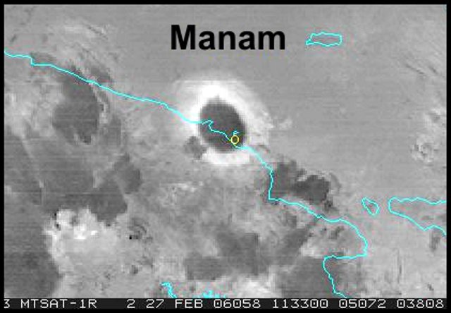 |
Figure 25. An MTSAT image of the eruption cloud over Manam captured at approximately 2145 (1145 UTC) on 27 February 2006, showing a very strong hot spot. The image contains an 11-12 ?m enhancement. In past Manam eruptions where there has been a similar white halo around the thinning umbrella cloud, the cloud has later been verified as having a large ice and SO2 content (as well as fine ash and other volcanic aerosols). The warm temperature mass persisted for 2-3 hours, suggesting a prolonged, continuing eruption. Courtesy of Andrew Tupper. |
Fred Prata processed Manam ash cloud data using the Atmospheric Infrared Sounder (AIRS, which uses a grating spectrometer on the Aqua satellite). Prata produced the atmospheric SO2 analyses in the sequential images in figures 26 and 27, which show areas of greatest concentration displaced ~ 70 and ~ 100 km W of Manam, respectively. At the bull's-eye centers, figure 26 portrays a somewhat higher peak for the product of concentration and path length (milli-atmosphere-centimeter values), ~ 60, compared to figure 27, which indicates ~ 50. Figure 27 also contains a much larger low-value area, consistent with post-eruption dispersal. The 27 February eruption clearly emitted considerable SO2, with the two analyses on figures 26 and 27 yielding respective assessed masses of 0.027 Tg and 0.054 Tg of SO2.
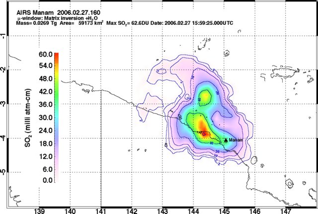 |
Figure 26. An AIRS image indicating the Manam ash plume's SO2 content at 1559 UTC on 27 February 2006. The area of detected SO2 coverage reported for this image was 59,173 km2. Further details about the image appear in the text on the image. Courtesy of Fred Prata. |
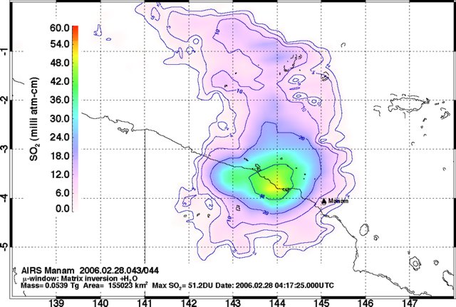 |
Figure 27. The Manam ash plume's SO2 content at 0417 UTC on 28 February 2006. The area of detected SO2 coverage reported for this image was 155,023 km2. Further details about the image appear in the text on the image. Courtesy of Fred Prata. |
RVO reported that the strong phase of the eruption declined around 0030 on 28 February. Earlier, during the height of the activity, incandescent lava fragments were thrown 700-800 m high above the volcano, but ejection heights later decreased to 200-300 m. Ash was deposited on the E part of the island and lava flowed down the SW valley. Field inspections on 28 February confirmed that a lava flow traveled down the SW valley to about 600 m elevation, a pyroclastic flow traveled down the same valley to about 500 m elevation, and the maximum ash thickness on the E part of the island was about 7-8 cm. Later, on 7 March, it was determined that pyroclastic flows had also traveled down the SE valley and that scoria and ashfall affected the area between Warisi and Bokure 1.
After mid-February, Manam's seismic station and radio communication with the observer at Bogia had both ceased operating. RVO noted that the island had been inhabited by about 300 former residents who returned to the island after evacuating following the 27 January 2005 eruption. (A March press report, below, indicated over 2,000 people on the island, including people who had previously refused to leave.) The mid-February Alert Level at the volcano was at Level 2. By 1 March, only gas was emitted from Southern Crater, no noises were heard, and weak incandescence was visible around the vent. Occasionally, incandescent lava fragments were thrown 100-150 m above the vent and fell into the crater. Main crater emitted occasional ash clouds, and then gas later in the day.
Based on information from RVO, the Darwin VAAC reported that a minor explosion occurred at Manam on 6 March. The height of the resultant plume was not reported and ash was not visible on satellite imagery. A report faxed from RVO said that during 9-11 March, both summit craters at Manam released gas, and seismicity then stood at moderate levels.
According to RVO, a recent (ambiguously disclosed) eruption had endangered about 49 people (mostly women) pelted by tephra who ran for their lives to take shelter at Dangale village to the N. The RVO team called the evacuation centers on the main island at Mangem and Asaruba where people from villages on the E part of the island were located and advised them not to go to the island unless clearance was given from the authorities. RVO warned of possible mudflows during heavy rainfall, moderate-to-high levels of seismicity, and sporadic explosions.
Press reports. On 15 March 2005 The National newspaper (online edition) reported that "[a]uthorities dispatched a vessel, the Motuan Chief, to the island [on the afternoon of 14 March] to evacuate over 2,000 islanders who had refused to move earlier or who had returned recently. A sudden explosion last Thursday [9 March] has left an elderly [man] from Wirisi village missing, believed covered by the pyroclastic [material] from the eruption . . .. Authorities . . . reported several houses burnt down from the hot emissions while others collapsed under the weight of ash dust and pyroclastic [material] . . .. [Q]uite a number of resettled people . . . have moved back to the island after an earlier evacuation and now are pleading to be evacuated back to the mainland following the recent volcanic activities.
"Some people from Warisi village who were at the [evacuation] centres on the mainland traveled back to Manam last Thursday to gather food from their gardens. They were to return to the [evacuation] centre but unfortunately their boat . . . was destroyed by rocks from the eruption."
A January 2006 article in the PNG Post-Courier (and online in the Pacific Islands Report) noted that the Red Cross and Red Crescent Societies had spent about US $377,000 on emergency aid for resettlement camps on the main island. The article noted that aid societies had helped the government, funding 350 houses constructed of bush-materials at the camps since October 2004. Those camps (also termed care centers) include Mangem, Asuramba (Asaruba?), and Potsdam.
Information Contacts: Ima Itikarai, Rabaul Volcano Observatory (RVO), P.O. Box 386, Rabaul, Papua New Guinea; Andrew Tupper, Darwin Volcanic Ash Advisory Centre (VAAC), Bureau of Meteorology, Northern Territory Regional Office, PO Box 40050, Casuarina, Northern Territory 0811, Australia (URL: http://www.bom.gov.au/info/vaac/); Bonney Bonsella and Thomas Kilala, The National Online, Lot 13 Section 38, Waigani Drive Hohola, PO Box 6817 Boroko, National Capital District, Papua New Guinea (URL: http://www.thenational.com.pg/); PNG Post-Courier; Pacific Islands Report.
Mild behavior during most of March-July 2006 but minor 18 July eruption
In the past year Manam issued energetic eruptions. In contrast, Rabaul Volcanological Observatory (RVO) described milder behavior during March-July 2006.
Although steam emissions from Main and Southern craters dominated in early March, small eruptions occurred on 3 and 6 March 2006. A 7 March pyroclastic flow descended SE valley halting at 500 m elevation. Scoria and ashfall affected the E part of the island between the coastal settlements of Warisi and Bokure (see annotated image in BGVN 30:02). Fine ashfall was reported along the SW part of the island at night. On 22, 24-25, and 28-31 March, Main Crater emitted thick white vapor, while Southern Crater released white and blue vapor. Pale gray ash clouds were reported 30-31 March.
Glowing-lava fragments discharged from Southern Crater late on 31 March. During 4-20 March there was low-to-moderate seismicity. Audible noises, weak to roaring, were reported from Main Crater on 13 April, but no glow was seen at night. Clear weather on 14 April revealed both craters releasing diffuse white vapor.
During 26 April to 2 May, ash was observed on satellite imagery at ~ 3 km altitude On 24 and 25 May, an ash plume extended ~ 100 km WNW. Another ash plume was visible on 26 May, reaching an altitude of ~ 3 km altitude and drifting 48 km WNW.
According to Darwin VAAC, a pilot reported that an ash cloud from Manam reached altitudes of ~ 4.6 km on 17 July and drifted N. Ash was not visible on satellite imagery due to local cloud cover. The Darwin VAAC reported an ash cloud on 18 July moving N at an unknown altitude. On 29 July an ash cloud was visible on satellite imagery drifting WNW at an altitude of ~ 3 km.
Information Contacts: Ima Itikarai and Herman Patia, Rabaul Volcano Observatory (RVO), P.O. Box 386, Rabaul, Papua New Guinea.
Mild eruptive activity between August 2006 and May 2007
Eruptive activity at Manam has generally been low following a significant explosion in late February 2006 (BGVN 31:02). Between March and July 2006 the Rabaul Volcano Observatory (RVO) reported intermittent, milder, ash explosions (BGVN 31:06). Similar variable activity has continued into early May 2007, with plumes frequently identified on satellite imagery by the Darwin Volcanic Ash Advisory Centre (VAAC).
RVO received a report that four people were swept away by a mudflow in the early hours of 13 March following heavy rainfall on the northern part of the island. A 5th person was reportedly critically wounded and in a hospital.
Activity during August-December 2006. On 4 and 5 August, an ash plume was visible on satellite imagery extending 30 km NW. Ash plumes were emitted again during 14-15August. Over the next couple of days, the emissions became more diffuse and weak incandescence was observed at night. Based on pilot reports and satellite imagery, continuous emissions during 17-21 August eached altitudes of 3.7 km and drifted NW. Eruptive activity from Main Crater during 22-23 August consisted mainly of dark brown-to-gray ash plumes that rose 1-2 km above the summit and drifted W and NW. The Darwin VAAC reported that eruption plumes were visible on satellite imagery on 23 and 26 August, extending NW. Southern Crater continued to release only diffuse white vapor.
From the end of August to 5 September 2006, the Darwin VAAC reported that ash-and-steam plumes reached altitudes of 4.6 km and drifted W. Steam plumes with possible ash were visible on imagery below 3 km and drifted NE. RVO reported mild eruptive activity during 15-17 October that consisted of steam and ash plumes. White vapor plumes were visible from Southern Crater and intermittently from Main Crater. Main Crater produced gray ash plumes on 19 October. Weak incandescence was seen during 15-17 and 29 October.
During 1-13 November, white vapor plumes rose from Southern and Main craters. Incandescence was noted from both craters during 8-10 November and from Main Crater on 12 November. On 13 November a diffuse plume seen on satellite imagery drifted W. Steady incandescence was again observed from Main Crater during 8-10 December and bluish white vapor emissions during 6-9 December changed to a darker gray on 10 December. Weak glow continued from Main Crater during 14-18 December and a white vapor plume rose just above 2 km altitude. Based on satellite imagery, diffuse plumes drifted mainly W during 13-15 December. The daily number of volcanic earthquakes fluctuated between 700 and 1,000.
Activity during January-May 2007. RVO reported that mild eruptive activity and emissions of white vapor plumes from Main Crater were observed during 1-14 January. Brown-to-gray ash plumes accompanied emissions on 6 and 9-11 January; and nighttime incandescence was observed intermittently. White vapor clouds were occasionally released from Southern Crater. Seismic activity was at low to moderate levels; the daily number of low-frequency earthquakes fluctuated between 500 and 1,000.
Satellite imagery showed diffuse plumes drifting WSW on 15 February. Southern Crater emitted gray ash plumes during 15-19 February and white vapor plumes on 21 February. Continuous gray ash plumes from Main Crater rose to an altitude of 2.3 km and drifted SE during 19-21 February. The daily number of low-frequency earthquakes fluctuated between 400 and 500 during 22-24 February before the seismograph developed technical problems.
Mild eruptive activity continued during 22 February-10 March. Main Crater forcefully released variable gray ash clouds on 22 February that rose less than 1 km above the summit before being blown SE. Incandescence was also visible that day. Poor weather prevented observations for the remainder of the month. When the clouds cleared on 3 March, Main Crater was seen sending ash clouds less than 500 m high. Glow was visible during 2-5 and 9-10 March. Southern Crater released occasional diffuse gray ash clouds on 3-4 and 6 March, but only white vapor on 5 and 7-11 March.
Main Crater continued to release occasional low-level ash clouds through 6 April. Incandescence was visible during clear weather on the nights of 11-12 and 16-18 March. Southern Crater released diffuse white vapor on 11-12 and 15 March; however, diffuse ash clouds were reported on 16-20 March. Weak roaring noises were heard on 24 March, and on 7, 12, and 26 April. Low-level plumes were seen during 25-26 April, and a small plume was blowing W on 28 April. Weak incandescence was again visible from Main Crater on 2 and 4 May. Diffuse plumes were seen in satellite imagery on 6 and 23 May. Seismic activity was at a low level, with the daily number of volcanic earthquakes between 800 and 1,000 events.
Thermal satellite data. Thermal anomalies were not detected by Moderate Resolution Imaging Spectroradiometers (MODIS) for 9 months after events related to the 27-28 February 2006 explosion. Anomalies reappeared in December, with hot pixels detected on 5, 7, 9, 10, 12, and 14 December 2006. Another anomaly was recorded on 19 April 2007. Additional thermal anomalies were present on 16 and 23 May 2007. Most of the pixels were located near the summit, or slightly towards the NE. The May anomalies were the furthest down the NE Valley.
Information Contacts: Herman Patia and Steve Saunders, Rabaul Volcano Observatory (RVO), P.O. Box 386, Rabaul, Papua New Guinea; Darwin Volcanic Ash Advisory Centre (VAAC), Bureau of Meteorology, Northern Territory Regional Office, PO Box 40050, Casuarina, Northern Territory 0811, Australia (URL: http://www.bom.gov.au/info/vaac/); Hawai'i Institute of Geophysics and Planetology (HIGP) Hot Spots System, University of Hawai'i, 2525 Correa Road, Honolulu, HI 96822, USA (URL: http://modis.higp.hawaii.edu/); NASA Earth Observatory (URL: http://earthobservatory.nasa.gov/).
Mild eruptions and subdued seismicity during August 2006-May 2007
Our previous Manam report (BGVN 37:04) discussed activity from August 2006 into May 2007. Throughout May and into September 2007, Manam continued to show activity, but the emissions were mild and the seismicity, ever present, was very subdued. The Main Crater continued to release occasional pale gray ash clouds (table 4).
Table 4. Manam activity mid-May into September; the only data source for 17 September is the Darwin VAAC.
| Month | Vapor Emissions | Ash Emissions | Thermal Anomalies | Incandescence | Seismicity (events) |
| May 2007 | 25 May (diffuse) | 10-16 May (pale gray) | 16-23 May | 8, 10, 12-13, 29 May | 500-1000 |
| Jun 2007 | 23 Jun | -- | -- | -- | 600-1050 |
| Jul 2007 | 1-4 Jul, 12 Jul (white) | 16-17, 22-23, 26-27 Jul (pale gray) | -- | 4, 7, 12-13, 16-20, 23, 26-27 Jul | 600-1050 |
| Aug 2007 | 8-9 Aug (blue), 10 Aug | 21 Aug | -- | 2-3, 21 Aug | 800-1000 |
| Sep 2007 | -- | 17 Sep | -- | -- | -- |
Thermal anomalies were detected at Manam by the Moderate Resolution Imaging Spectroradiometer (MODIS) on 16 and 23 May 2007. These anomalies were located down the NE Valley.
On 25 May the Rabaul Volcano Observatory (RVO) reported diffuse plumes from Manam. Based on satellite imagery and information from the Darwin VAAC, these plumes rose to an altitude of 3 km and drifted SW and W.
On those occasions in May where incandescence was visible, area residents heard no noises. The Southern Crater continued releasing diffuse white vapor; however, area residents noted the absence of any noise or glow.
Seismicity throughout May and into early June was low-to-moderate. Through 19 June 2007, low-frequency earthquakes occurred, but no noises were heard. On 23 June, based on satellite observations, the Darwin VAAC reported a low-level eruption that emitted a narrow plume of gas and vapor. It extended 40 km WNW and ascended to an altitude of ~ 3.4 km. The presence of ash was not discernable from the satellite data.
During 1-4 and 12 July 2007, the RVO reported that mild eruptions continued to release occasional diffuse white vapor from Main Crater. Occasional pale gray ash clouds emerged during 16-17, 22-23, and 26-27 July 2007. The ash clouds rose to less than a kilometer above the summit before being blown NW, resulting in fine ashfall. Incandescence was occasionally visible during July. The Southern Crater continued to release diffuse white vapor throughout July with an absence of glow or noise.
Throughout August, Manam continued low level activity. Visual observation of the summit was hampered by clouds most of the time; however, when clear, both craters were releasing primarily thin white vapor. Blue vapor accompanied the white vapor emission from Main Crater on 8-9 August. Based on satellite image observations and information from the RVO, the Darwin VAAC reported that an eruption plume from Manam rose to an altitude of 3 km a.s.l. on 10 August and drifted W. Seismic activity in August remained low and dominated by low-frequency earthquakes. Manam generally lacked significant activity continuing through the end of August and into September 2007. On 17 September, the Darwin VAAC reported that ash plumes from Manam rose to an altitude of 3.7 km a.s.l.
Information Contacts: Herman Patia and Steve Saunders, Rabaul Volcano Observatory (RVO), P.O. Box 386, Rabaul, Papua New Guinea; Darwin Volcanic Ash Advisory Centre (VAAC), Bureau of Meteorology, Northern Territory Regional Office, PO Box 40050, Casuarina, Northern Territory 0811, Australia (URL: http://www.bom.gov.au/info/vaac/); Hawai'i Institute of Geophysics and Planetology (HIGP) Hot Spots System, University of Hawai'i, 2525 Correa Road, Honolulu, HI 96822, USA (URL: http://modis.higp.hawaii.edu/); NASA Earth Observatory (URL: http://earthobservatory.nasa.gov/).
Low-level eruptions continue in late 2007 and early 2008
Low-level seismicity and mild eruptions occurred from mid-May 2007 through mid-September 2007 (BGVN 32:08). This report addresses activity between the end of September 2007 through mid-May 2008, with gaps in reporting as noted. For the most part, Manam remained at a low eruptive level, but four fatalities from the early 2007 activity were noted in news reports.
According to the Rabaul Volcano Observatory (RVO), ash plumes were occasionally emitted both during the first half of October 2007, during 5-8 November 2007, and on 27 December 2007. The Darwin Volcanic Ash Advisory Centre (VAAC) noted that one plume rose to 3.7 km during 3-9 October and another rose to 3 km on 27 December. White vapor plumes were also emitted occasionally during October and November, and incandescence was reported on 29 September, 1 October, 10-11 October, 30 October, and 4-5 November. Roaring noises were heard on 30 October.
Manam remained quiet during January and February 2008. Both the Main Crater and South Crater continued to release thin to thick white vapor. At Main Crater, a weak red glow was visible at night on 10 January, and a fluctuating red glow was visible from the Main Crater during 8-11 February and 22-25 February. Seismic activity was at the low-to-moderate level through 14 January, when lightning struck the monitoring equipment. The number of daily low-frequency volcanic earthquakes up through the lightning strike ranged between 500 and 970. The equipment was fixed on 28 February. On 29 February, 770 low frequency earthquakes were recorded. On 9-10 February, pale gray ash clouds were emitted from the Main Crater.
RVO reports covering the interval March and April 2008 were unavailable at the time of this writing. RVO reported Manam as quiet during May 2008, emitting only variable amounts of white vapor. Glow was reported from Main Crater on the nights of 16-20 May.
Editors searched MODVOLC thermal alerts on 10 June 2008 and found that they occurred on six days during the interval April-July 2007. After previously mentioned alerts on 16 and 23 May 2007 (UTC)(BGVN 32:08), the only subsequent alerts occurred on 8 June and 26 July 2007 (UTC).
The Darwin VAAC reported plumes to altitudes of several kilometers from Manam on 2 April, 14-15 April (ash-and-steam), 23-29 April, and 11-12 May 2008. The plumes during 11-12 May rose to an altitude of 3 km and extended ~ 36 km laterally.
Fatalities and injury. To supplement our previous report (BGVN 32:08), we note that an article by Reuters on 20 March 2007 reported that during the past week a mudslide on Manam killed four people in "an avalanche of ash and mud," and that a fifth person was seriously injured. RVO noted that they received word of the event on the 15th, suggesting the event was probably on 14 or 15 March. It occurred in a valley on the island's N side.
The news account quoted Health Minister Sir Peter Barter as saying, "The valleys are very dangerous and I am appealing to everyone not to venture into any of the valleys as there are huge quantities of ash and mud deposited on higher slopes. After heavy rain that has been experienced, the mud and loose material becomes a major risk for anyone venturing into the potential path of an avalanche."
Information Contacts: Herman Patia and Steve Saunders, Rabaul Volcano Observatory (RVO), P.O. Box 386, Rabaul, Papua New Guinea; Darwin Volcanic Ash Advisory Centre (VAAC), Bureau of Meteorology, Northern Territory Regional Office, PO Box 40050, Casuarina, Northern Territory 0811, Australia (URL: http://www.bom.gov.au/info/vaac/).
Low level eruptions continue in 2008
Table 5 characterizes plumes from Manam during 2 April 2008 to 7 October 2008 (BGVN 33:04 listed plume activity through mid-May 2008). The International Civil Aviation Organization (2008) noted that during July 2007-June 2008, the Darwin Volcanic Ash Advisory Centre issued 23 Volcanic Ash Advisories resulting from 10 Manam eruptions.
Table 5. Plumes from Manam from 2 April to 7 October 2008. Courtesy of Darwin Volcanic Ash Advisory Centre.
| Date | Observation |
| 02 Apr 2008 | Low-level plume drifted SW. |
| 14-15 Apr 2008 | Low-level ash-and-steam plume drifted WNW. |
| 23-29 Apr 2008 | Diffuse plume below 3 km altitude; drifted NW. |
| 11-12 May 2008 | Plumes to 3 km altitude; drifted SE. |
| 29 Jul 2008 | Plumes to 2.4 km altitude; drifted WNW. |
| 30 Jul 2008 | Plume to 2.4 km altitude; drifted NW. |
| 16-17 Aug 2008 | Ash plumes to 1.5 km altitude; drifted NW. |
| 19 Sep 2008 | Ash plumes to 1.8 km altitude; drifted NW. |
| 07 Oct 2008 | Ash plumes to 2.4 km altitude; drifted NW. |
According to the Rabaul Volcano Observatory, people watching Manam described it as generally quiet from April through October 2008. Occasional ash plumes in this period resulted in aviation ash advisories (table 5). Both craters released variable amounts of white vapor. No audible noises were heard during this period and no glow was visible at night except for a weak steady glow visible at night during 18-22 May.
Seismic activity was low to moderate, dominated by low frequency volcanic earthquakes (numbers fluctuated daily between 650 and 1,000). No high frequency earthquakes were recorded during the period and no significant movement was recorded by the tiltmeter.
The only MODIS/MODVOLC satellite thermal anomaly for Manam during 2008 as late as 6 November was a 1-pixel anomaly measured 28 July at 1555 UTC from the Aqua satellite system.
Reference. International Civil Aviation Organization, 2008, Twelfth Meeting of the Communications/Navigation/Surveillance and Meteorology Sub-Group of APANPIRG (CNS/MET/SG/12), Bangkok, Thailand, 21-25 July 2008: Information Paper 10, VAAC Darwin Report July 2007-June 2008, 12 p. (URL: http://www.icao.or.th/2008/cnsmet_sg12/).
Information Contacts: Herman Patia and Steve Saunders, Rabaul Volcano Observatory (RVO), P.O. Box 386, Rabaul, Papua New Guinea; Darwin Volcanic Ash Advisory Centre (VAAC), Bureau of Meteorology, Northern Territory Regional Office, PO Box 40050, Casuarina, Northern Territory 0811, Australia (URL: http://www.bom.gov.au/info/vaac/).
Moderate ash plumes continue into 2009
Ash plumes from Manam were reported intermittently between 2 April and 7 October 2008 (BGVN 33:09), although the volcano was generally quiet. Additional ash plumes were seen in satellite imagery and reported by the Darwin Volcanic Ash Advisory Centre on 20 November, 15 December, and 19 December 2008. Plumes rose to 3 km altitude on each of those days, and drifted 55 km downwind on 20 November. No other plumes were noted through 23 January 2009.
On most days during January 2009 when the summit area was clear, observers noted Southern Crater releasing variable white vapor. No glow was observed and no audible noises were heard. Main Crater was generally quiet with activity similar to Southern Crater's vapor emissions on most days. In contrast, diffuse blue vapor was visible on 21 and 22 January. The occasional dull, and sometimes bright, steady glow reported in previous months was observed on 1, 19-20, and 26 January. On 1 January observers heard some roaring and rumbling noises.
No seismic recording was conducted throughout the month of January due to instrumentation problems. Only one MODVOLC thermal alert was detected between 8 October 2008 and 23 January 2009. That one took place on 20 January 2009 (2 pixels).
Information Contacts: Rabaul Volcano Observatory (RVO), P.O. Box 386, Rabaul, Papua New Guinea; Darwin Volcanic Ash Advisory Centre (VAAC), Bureau of Meteorology, Northern Territory Regional Office, PO Box 40050, Casuarina, NT 0811, Australia (URL: http://www.bom.gov.au/info/vaac/); Hawai'i Institute of Geophysics and Planetology (HIGP) Thermal Alerts System, School of Ocean and Earth Science and Technology (SOEST), Univ. of Hawai'i, 2525 Correa Road, Honolulu, HI 96822, USA (URL: http://modis.higp.hawaii.edu/).
Intermittent ash and glow at both craters during 2009
The volcano was generally quiet between 2 April 2008 and 26 January 2009, with intermittent ash plumes and vapor emissions (BGVN 34:01). This same pattern of activity at Manam continued through the rest of 2009.
Glow from Main and Southern craters was reported again during January-April, July, September, and October. Thermal anomalies near the summit were recorded by the MODVOLC system on 29 June, 16 July, 8-9 and 17 August, 26 September, and 4 October.
Emissions from both craters during February 2009 consisted of white vapor. A dull glow was visible at night from both craters on 23 and 25 February. Occasional night-time glow was observed in March.
Both Main and Southern craters released variable white vapor on most days in April, seen when the summit was clear. Steady glow from Main Crater was observed on the nights of 6, 17, and 26 April. The earthquake recorder was repaired on 5 April 2009. Seismic activity remained at low level, with the number of daily volcanic earthquakes ranging between 610 and 980 events.
The Darwin VAAC reported that on 13 May an ash plume rose to an altitude of 3 km and drifted ~ 20 km SE. Another ash plume on 8 June rose to an altitude of 2.4 km and drifted ~ 40 km NW.
Mild eruptive activity at Southern Crater began on 11 July. Southern Crater released diffuse white vapor during 1-9 and 14-15 July. Diffuse pale-gray ash clouds were reported on 11 July and from 16 July until the end of the month. The ash plumes rose less than 1 km above the summit before being blown downwind and causing fine ashfall. Weak roaring noises were heard from 18 to 21 July, and fluctuating glow was visible at night on 19, 23-24, and 28-29 July. Main Crater released variable amounts of white vapor on most days in July; however, pale-gray ash clouds were emitted during the last three days of the month. Occasional glow was visible at night on 24 July. Seismic activity was low to moderate, dominated by low-frequency volcanic earthquakes (800 to 1,000 events/day).
Mild eruptions again occurred at Southern Crater on 3-4 September and gray ash clouds rose 600-700 m above the summit. The ash clouds were then blown NW, resulting in fine ashfall on that side of the island. At other times white vapor was released from both craters, accompanied at times by diffuse blue vapor from Southern Crater. Occasional glow was visible from Southern Crater on 2, 9, and 16 September, and from Main Crater on 18, 19, and 23 September. Seismicity remained low to moderate until the seismic system developed power problems on 17 September. Daily totals for the low-frequency earthquakes ranged between 210 and 1,010. No high-frequency earthquakes were recorded.
During October, a steady glow from the two craters began on the 7th. The glow at Southern Crater lasted for a week, while at Main Crater it continued until 20 October.
The Darwin VAAC reported that during 1-2 November ash plumes rose to an altitude of 2.1 km and drifted 35-55 km NW and N. On 12 December an eruption plume rose to an altitude of 3 km and drifted 75 km N; meteorological clouds prevented identification of ash in imagery after the initial advisory was issued.
Information Contacts: Rabaul Volcano Observatory (RVO), PO Box 386, Rabaul, Papua New Guinea; Darwin Volcanic Ash Advisory Centre (VAAC), Bureau of Meteorology, Northern Territory Regional Office, PO Box 40050, Casuarina, NT 0811, Australia (URL: http://www.bom.gov.au/info/vaac/); Hawai'i Institute of Geophysics and Planetology (HIGP) Thermal Alerts System, School of Ocean and Earth Science and Technology (SOEST), Univ. of Hawai'i, 2525 Correa Road, Honolulu, HI 96822, USA (URL: http://modis.higp.hawaii.edu/).
Intermittent ash plumes continue; ~14,000 people still displaced
Intermittent ash plumes and steam emissions at Manam have been reported between 2 April 2008 and 2 November 2009, but the volcano has been relatively quiet (BGVN 34:01 and 34:11). Based on analyses of satellite imagery, the Darwin Volcanic Ash Advisory Centre reported that on 12 December 2009 an eruption produced a plume that rose to an altitude of 3 km and drifted 75 km N. According to a report by the Rabaul Volcano Observatory, the volcano was quiet again throughout February 2010. However, steam emissions were reported, and a dull glow from the Main Crater was visible on the night of 16 February. There were no MODVOLC thermal alerts between 3 October 2009 and mid-April 2010.
A January 2010 report by the United Nations Office for the Coordination of Humanitarian Affairs discussed refugees originally evacuated from Manam Island in November 2004 after several deadly eruptions (BGVN 29:11). In early 2010 there remained ~ 14,000 people living in camps on the nearby mainland unable to return home because of ongoing volcanic hazards. In addition, "a government plan to permanently resettle the [evacuees] inland was never realized and local and international assistance has all but disappeared."
Information Contacts: Ima Itikarai, Rabaul Volcano Observatory (RVO), PO Box 386, Rabaul, Papua New Guinea; Darwin Volcanic Ash Advisory Centre (VAAC), Bureau of Meteorology, Northern Territory Regional Office, PO Box 40050, Casuarina, NT 0811, Australia (URL: http://www.bom.gov.au/info/vaac/); Hawai'i Institute of Geophysics and Planetology (HIGP) Thermal Alerts System, School of Ocean and Earth Science and Technology (SOEST), Univ. of Hawai'i, 2525 Correa Road, Honolulu, HI 96822, USA (URL: http://modis.higp.hawaii.edu/); ReliefWeb, UN Office for the Coordination of Humanitarian Affairs (OCHA) (URL: https://reliefweb.int/).
Ejecting lava fragments and ash plumes during August-October 2010
After an eruption produced a plume on 12 December 2009, Manam was quiet through February 2010 (BGVN 35:02). The volcano remained quiet until August 2010, when South Crater became active. Main Crater produced diffuse white vapor, sometimes tinged blue, in August and September.
According to the Rabaul Volcano Observatory (RVO), on 10 August, incandescence from Manam's South Crater was visible at 4-5 minute intervals. The next day, diffuse black ash plumes rose a few hundred meters above the rim. Steady incandescence was accompanied by periodic ejections of lava fragments to 400-500 m above the rim; most of the ash fell back into the crater. Based on analysis of satellite imagery, the Darwin Volcanic Ash Advisory Centre (VAAC) reported that, at 1232 on 14 August, ash plumes at an altitude of 2.4 km had drifted 55 km NW.
RVO reported that, during 13-28 August, incandescence from Manam's South Crater was visible at night. During 27-28 August, incandescence emanated from Main Crater also and brightened every 15-20 minutes. At that time, incandescent lava fragments ejected tens to hundreds of meters above South Crater according to observers in Bogia, ~23 km SSW. Weak explosions were heard at 15-20 minute intervals.
During 28-29 August, emissions from Main Crater were occasionally accompanied by diffuse gray ash plumes. Incandescent lava fragments continued to be ejected by South Crater and probably by Main Crater also. Based on analysis of satellite imagery, the Darwin VAAC reported that, at 1732 on 30 August, an ash plume reached an altitude of 2.4 km and drifted 55 km NW. On 30 August, plumes rose from both Manam's Main Crater and South Crater. The emissions rose from South Crater at 5-10 minute intervals. During 30 August-2 September, incandescence was observed.
During 5-7 September, ash plumes rose from Manam's South Crater, and light ashfall was reported on the NW part of the island. Subsequently, the Darwin VAAC reported ash plumes on 22 October (plume rose to an altitude 4.3 km and drifted 130 km NW) and on 28 October (plume rose to an altitude of 4.6 km and drifted ~95 km NW).
Information Contacts: Rabaul Volcano Observatory (RVO), PO Box 386, Rabaul, Papua New Guinea; Darwin Volcanic Ash Advisory Centre (VAAC), Bureau of Meteorology, Northern Territory Regional Office, PO Box 40050, Casuarina, NT 0811, Australia (URL: http://www.bom.gov.au/info/vaac/); Hawai'i Institute of Geophysics and Planetology (HIGP) Thermal Alerts System, School of Ocean and Earth Science and Technology (SOEST), Univ. of Hawai'i, 2525 Correa Road, Honolulu, HI 96822, USA (URL: http://modis.higp.hawaii.edu/).
Ashfall, pyroclastic flows, and seismicity in late December 2010
This report discusses Manam behavior during November 2010 to early 2011. As previously reported, during August-October 2010, lava fragments and ash plumes rose from Manam (BGVN 35:09). Similar activity continued through at least 4 January 2011. Over 10,000 former island residents remain in care centers on the mainland (see below).
During the reporting period, the Rabaul Volcano Observatory (RVO) reported that the Main Crater produced mostly white plumes that were occasionally laden with ash. Incandescent material was ejected at times and mainly fell back in and around the crater, but occasionally spilled into the SE and SW valleys.
Based on analysis of satellite imagery, the Darwin Volcanic Ash Advisory Centre (VAAC) reported that ash plumes during 14-16 November 2010 rose to an altitude of 2.7 km and drifted ~95 km NW.
RVO reported that light brown to dark gray ash plumes rose 400-500 m above the South Crater during late November. People living on the island reported occasional roaring and rumbling noises. A new episode of eruptive activity began at South Crater on 25 December and was characterized during 25-29 December by rising ash plumes and ejections of incandescent lava fragments. Electronic tilt measurements showed a strong inflationary trend during 24-26 December but this slowed down on 26 December.
On 30 December 2010, activity from South Crater increased and was reported by observers in Bogia (on the mainland 20 km SSW). A dense ash plume rose 3 km above the summit crater and drifted NW, causing light ashfall in Tabele (4 km SW of Manam). An observer at Tabele confirmed the eruption and also reported that three pyroclastic flows descended the SE valley, stopping within a few to several hundred meters from the coastline. The first and largest pyroclastic flow devastated a broad unpopulated area between Warisi (E of Manam) and Dugulava (S of Manam) villages. RVO increased the Alert Level to Stage 3. Later that day, both ash emissions and the ejection of incandescent fragments diminished.
During early January 2011, plumes, sometimes containing ash, continued to rise above the South and Main Craters. RVO reported low roaring from the South Crater and incandescence was reported at times. On 8 January, the Alert Level was lowered from Stage 3 to Stage 2.
Seismicity and MODVOLC thermal alerts. Seismic data were not available during late November because of technical problems. Seismicity was low on 24 December, increased slightly after 25 December, then reached a point after 27 December where it fluctuated at and above moderate level. RVO reported seismicity during early January 2011 to be at a moderately low to moderate level.
Between 16 October 2010 and 10 January 2011, MODVOLC detected thermal anomalies on 25 days, mostly during late November and December. After 10 January, no thermal anomalies were detected through at least 16 February.
Multi-year evacuation. The UN's IRIN (Integrated Regional Information Networks) discussed Manam evacuees in reports issued 5 May and 20 December 2010. The 5 May 2010 report stated that "Around 14,000 islanders have been living in three care centres in the mainland province of Madang since November 2004. In March 2010 there was discussion that the displaced persons might be allowed to voluntarily return home to Manam Island."
According to the report, "A July 2009 assessment by the National Disaster Centre, the UN, and Oxfam concluded that living on the island was not a viable option because of a lack of access to arable land and public services, and the risk of further volcanic activity."
"The decision to begin returning residents was taken following heightened tensions between islanders and local residents (they speak the same language), largely over land issues. With little to no assistance, many of the IDPs rely on local gardening as their only source of food and livelihood, meaning they often encroach on nearby land.
"In March 2010, the National Executive Council (NEC) approved the establishment of the Manam Task Force Committee to manage the needs of the displaced islanders, with the primary goal of finding a suitable location for their permanent relocation."
Information Contacts: Rabaul Volcano Observatory (RVO), PO Box 386, Rabaul, Papua New Guinea; Darwin Volcanic Ash Advisory Centre (VAAC), Bureau of Meteorology, Northern Territory Regional Office, PO Box 40050, Casuarina, NT 0811, Australia (URL: http://www.bom.gov.au/info/vaac/); Hawai'i Institute of Geophysics and Planetology (HIGP) MODVOLC Thermal Alerts System, School of Ocean and Earth Science and Technology (SOEST), Univ. of Hawai'i, 2525 Correa Road, Honolulu, HI 96822, USA (URL: http://modis.higp.hawaii.edu/).
Eruptions ongoing from August 2010 to January 2011
Manam eruptions continued, and from 13 November 2010 to 3 January 2011, the MODVOLC satellite-based system registered almost daily alerts. Fewer alerts continued into at least July 2011. This report also describes activity as provided by the Rabaul Volcanological Observatory (RVO) during 31 December 2010 to 11 January 2011, augmenting and extending our previous Bulletin reports (BGVN 35:02, 35:09, and 36:01-02). A map illustrating the edifice's remarkably symmetric form appears below (figure 28).
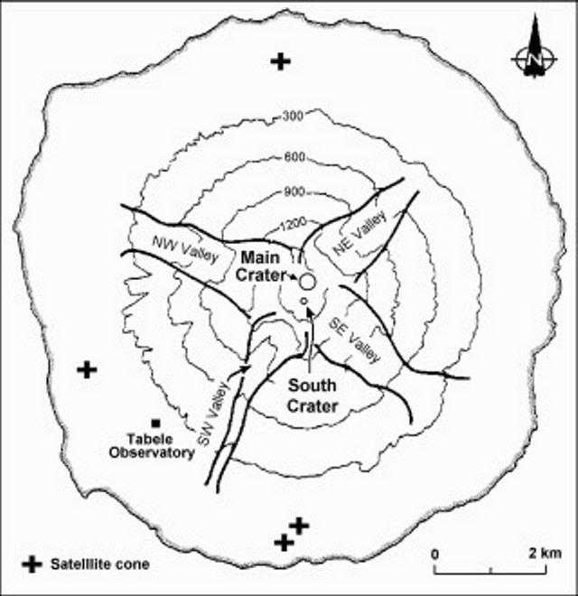 |
Figure 28. Map of the island of Manam showing the locations of the Main Crater and South Crater and the four radial "avalanche valleys" that channel pyroclastic flows from the summit. Plus symbols indicate locations of satellitic cones. Base map after Palfreyman and Cooke (1976). |
As a review, in BGVN 36:01-02 we noted a new episode of eruptive activity that began on 25 December 2010 and escalated on 30 December, culminating with several destructive pyroclastic flows.
On 31 December 2010, white vapor rose from the crater. Later that day, activity increased again. Gray ash plumes rose 200-300 m above the South Crater and also above the Main Crater. Low booming sounds were noted and incandescence from the crater was observed at night. During 1-4 January eruptive activity continued from South Crater and gray-to-black ash plumes rose above the summit crater. Incandescence emanated from the crater. During 3-4 January incandescent fragments were ejected onto the flanks and rolled down the SE valley. White vapor rose from the Main Crater.
On the website Malum Nalu viewed on 2 January 2011 Sir Peter Leslie Charles Barter (former Minister for Health, Papua New Guinean (PNG) government) reported that as the results of a series of eruptions on 25-30 December 2010, followed by larger eruptions, some panic occurred by people that had returned to Manam Island. At Dugalava, a spokesman for the people told the provincial disaster office that more than 1,000 people needed to be evacuated. Barter flew with former Madang Province Governor and current PNG Attorney General Sir Arnold Amet to Manam on 1 January 2011 for an aerial inspection. At that time there was evidence of lava flows in two valleys, but most of the villages were intact and the eruption had subsided.
RVO reported that during 5-6 January low roaring from Manam's South Crater was heard and weak but steady crater incandescence was observed at night. Diffuse blue vapor was emitted from South Crater on 6 January. During 6-8 January white vapor rose from Main Crater and incandescence from both craters was observed at night. Diffuse brown ash plumes occasionally rose from South Crater on 7 January. On 8 January the volcano Alert status was lowered from Level 3 to Level 2. During 8-9 January Main Crater emitted white vapor and South Crater produced occasional gray ash plumes that drifted to the SE part of the island. Emissions from Main Crater turned to gray on 10 January. White-to-blue vapor plumes rose from South Crater. Both craters were incandescent at night during 8-10 January.
On 11 January 2011, RVO reported that Southern Crater released weak volumes of white vapor, and a steady weak glow was visible at night. Main Crater had similar activity.
Satellite measurements. MODVOLC satellite thermal alerts vary significantly during July 2008-June 2011, with periods of up to months of quiet, and seven weeks of daily to near-daily interval of alerts near the end of 2010. During late July 2008 through mid-November 2010, the MODVOLC satellite thermal alerts system measured very infrequent thermal alerts of 1, 2, and, once, 3 pixels. During the periods of 29 July 2008-19 January 2009 and 4 October 2009-9 August 2010, no alerts were measured. However, during a period of ~7 weeks, 13 November 2010-3 January 2011, almost daily alerts were measured. Subsequently, only two additional, 1-pixel Terra satellite thermal alerts were measured through mid-June 2011; one on 10 January 2011 at 1255 UDT and one on 6 March 2011 at 1300 UDT. Thus, the period of nearly daily measured thermal alerts during the end of 2010 appears to be rather anomalous. Several periods of thermal alerts were measured 28-30 June and 14-19 July 2011, but not accompanied with field observations.
Reference. Palfreyman, W.D., and Cooke, R.J.S., 1976, Eruptive history of Manam volcano, Papua New Guinea in Johnson R.W. (ed.), Volcanism in Australasia, Elsevier, Amsterdam, p. 117-131.
Information Contacts: Rabaul Volcano Observatory (RVO), PO Box 386, Rabaul, Papua New Guinea; Malum Nalu (URL: http://malumnalu.blogspot.com/2011/01/volcano-erupts-on-manam-island.html); Hawai'i Institute of Geophysics and Planetology (HIGP) MODVOLC Thermal Alerts System, School of Ocean and Earth Science and Technology (SOEST), Univ. of Hawai'i, 2525 Correa Road, Honolulu, HI 96822, USA (URL: http://modis.higp.hawaii.edu/); Darwin Volcanic Ash Advisory Centre (VAAC) (URL: http://www.bom.gov.au/info/vaac/).
Sporadic heightened activity, 2011-2013; new vents
Our last report on Manan (BGVN 36:06; figure 29) discussed field observations through 11 January 2011. The following summarizes available Rabaul Volcano Observatory (RVO) reports issued since that time through May 2013. Pyroclastic flows took place during the reporting interval, specifically four times on 16 June 2012, and another four times on 30 July 2012, all of which traveled down the SE valley. No injuries were reported. In addition there were lava fountains, several lava flows, and some cases of sustained emissions lasting hours. Occasional ash plumes triggered the Darwin Volcanic Ash Advisory Centre (Darwin VAAC) to issue notices. Some ash plumes drifted over 200 km. Loud noises, rumbling, tephra ejected above or outside the confines of the crater, and night glow were common observations.
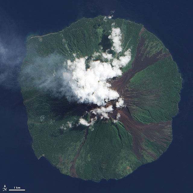 |
Figure 29. This ALI satellite photo was taken of Manam on [9 June 2009]. Courtesy of NASA Earth Observatory. |
2011 activity. During 1-19 August 2011, RVO reported Manam's summit area was obscured by weather clouds on most days. When the summit was clear to viewers on the mainland, 15-20 km away from Manam, both vents emitted white vapor plumes. Main Crater produced light-gray ash clouds during 13 and 17-18 August, and bright, steady incandescence was visible on most clear nights. August seismicity was dominated by volcanic tremor, but discrete high-frequency volcano-tectonic earthquakes were also recorded which, RVO noted, are not very common for Manam. An electronic tiltmeter located ~4 km SW from the summit craters continued to show inflation.
Based on analysis of satellite imagery, the Darwin VAAC reported a series of ash plumes which, during 18-21 August, rose to altitudes of 1.8-2.1 km and drifted 45-90 km NW and W. The VAAC next reported that on 18 October, ash plumes rose to 3.7 km altitude and drifted 150-170 km NW. During 19-21 October ash plumes rose to an altitude of 3.7 km and drifted 150-220 km W. For 11 November 2011, using both satellite imagery and a pilot observation, the VAAC reported an ash plume to an altitude of 3 km drifting up to ~90 km NE.
Activity continued in December 2011. Seismicity was assessed by Real-time Seismic Amplitude Measurements (RSAM) and varied at high levels between 200-350 RSAM. Both craters produced ash and lava fragments. The ash clouds rose to several hundred meters above the vents. Both vents often glowed at night, and expelled glowing fragments. Brown and grey ash was deposited in areas down wind. There were reports of a possible lava flow from the Southern Crater, with the 'V' shaped channel created by the 2005 blast being filled up.
2012 activity. RVO reported continued activity during January 2012. White vapor and grey-to-black ash emissions rising less than 200 m were observed from both craters throughout the month, sometimes with accompanying weak incandescent projections. From the Southern Crater, more sustained emissions on the evening of 20 January occurred with mainly black ash up to 400 m, trending to the SE. At that time low-energy projections observed at 3-4 minute intervals fell back inside the crater. Main Crater produced a bright steady glow and released thick white vapor with a strong blue tinge. On 23 January observers noted that there were possibly three vents emitting columns of vapor and ash. Seismicity during this time remained moderate to high, with a variable RSAM of 200-350.
RVO next reported mainly mild activity at Southern Crater during the first two weeks of May 2012. Diffuse white and blue vapor emerged during 5-6 and 13-14 May, and gray and gray-brown ash clouds were observed on 7, 9, and 12 May. Observers noted incandescence on the nights of 6, 8, 10-11, and 13-14 May, and glowing tephra occasionally falling outside of the crater.
Activity increased on 16 May 2012. Ash cloud colors changed from gray and gray-brown to gray and black. On 27 and 30 May Strombolian emissions occurred and, for periods lasting 1-2 hours, continuously ejected incandescent tephra. On 30 May two vents at the Southern Crater produced lava fountains. Ash plumes rose 100-400 m above the crater and drifted NW. Most of the tephra fell back into the crater, but some was channeled into the SE and SW valleys. Emissions from Main Crater were milder and characterized by white plumes and gray to gray-brown ash plumes noted during 6, 10-11, 13, 26, 28-29, and 31 May. Ash fell on the NW part of the island.
Seismicity during May 2012 maintained a moderate to moderately-high level and was associated with discrete low-frequency earthquakes and low-level, sporadic volcanic tremor in the background occurring during 1-9 May. Daily low frequency totals ranged between 880 and 970. The steady increase in RSAM observed in April continued until about 16 May, and fluctuated in an upward trend thereafter. The fluctuations reflected phases or episodes of low and moderate activity. The highest RSAM of 500 was reached on the 30th. After 30 May RSAM declined again to reach 350 by the end of May. Around this time tremor became dominant and overshadowed the discrete events, making it difficult to conduct event counts. The electronic tiltmeter (located 4 km SW) continued to show gentle uptilt towards the summit.
RVO reported low to moderate activity during 1-15 June 2012. Emissions consisted of gray and sometimes black ash clouds that rose from the crater on most days. Plumes drifted SE on 2 June and NW during 6-15 June. Ash fell in areas downwind between Yassa (WSW) and Baliau (NNW), and Warisi (ESE). Incandescent material was also ejected from the crater.
Pyroclastic flows on 16 June 2012 (at 0700, 0725, 0727, and 0729) all channelled into the SE valley. The last pyroclastic flow was perhaps the largest. It reached the lowest elevation, 300-400 m above sea level, but came to rest far from populated areas. Ash plumes from the pyroclastic flows rose ~1,000 m and drifted WSW and WNW. Small amounts of ash fell in villages between Dugulava (on the SW side of the island) and Yassa. Fine ash also fell in downwind areas on the mainland, including the Bogia government station (25 km SSW, on the mainland). Emissions from Main Crater were milder and mostly characterized by white and bluish plumes. Light gray plumes were noted during 2 and 8-9 June.
Ash fell in the NW part of the island. Weaker emissions occurred on 17 June, mostly consisting of steam with occasional ash. During 18-30 June gray and occasionally black ash clouds rose 100-150 m above the crater and drifted mainly NW. Incandescent tephra was ejected from the crater on most nights. Activity during 28-29 June was almost sub-Plinian. Emissions from Main Crater were milder and mostly characterized by white and bluish plumes. Gray ash plumes were emitted during 18, 23, 26-27, and 29 June. Incandescence from the crater was visible during 18, 20-22, and 24 June. Ash again fell in the NW part of the island. Seismic recording ceased during 12-27 June 2012 due to equipment failure at Bogia apparently caused by a lightning strike. During the period of data recording, seismicity remained at moderate to moderately high level, dominated by sub-continuous to continuous volcanic tremor. RSAM fluctuated between 250 and 550. High peaks in the RSAM between 4 and 10 June were associated with moderate to strong phases of eruptive activity described above. The electronic tiltmeter was generally stable during reporting period, but the long term trend showed slow inflation towards the summit area. When seismic recording resumed on 28 June 2012, the level of seismicity had risen slightly: RSAM 400-600. The high RSAM values corresponded to some of the moderate summit activity reported above. Seismicity was dominated by sub-continuous to continuous volcanic tremor. Around this time, the electronic tiltmeter remained out of service.
During the first half of June RVO recommended authorities declare a Stage 2 alert level. The level remained at Stage 2 for the remainder of June 2012. In their next available report, RVO noted that activity increased slightly during 15-31 July, except during 18-20 July when ash emissions decreased. During most of the reporting period, when visibility was clear, gray-to-sometimes-black ash plumes were observed rising 300-700 m above the crater discharging from two vents. The plumes mainly drifted NW, mainly affecting villages between Yassa and Kuluguma. Rumbling was heard on 25 July from Bogia. Bright glow visible at night was attributed to ejected incandescent tephra. Sub-Plinian activity occurred on most nights during 21-31 July. Small lava flows descended the SW flank.
Four pyroclastic flows traveled down the SE flank on 30 July (at 0638, 0640, during 1200-1300, and at 1428). The first event was the largest, and generated an ash plume that rose 1.8 km above the crater and drifted NW. As before, all four flows were again channeled into the SE valley. Emissions from Main Crater were milder and mostly characterized by white and bluish plumes, and occasional gray ash plumes. The Alert Level remained at Stage 2. Seismicity fluctuated, and was very high during 16-17 July 2012, dominated by sub-continuous to continuous volcanic tremors. RSAM ranged between 500 and 700. It declined thereafter to 150-300 units between 18 and 20 July before increasing again rapidly to 700 on the 21st. The reduced seismicity between 18 and 20 coincided with the reduced summit activity. Seismicity remained at a very high level (700 RSAM units) for the next few days before declining again to another low (300 RSAM units) on 26 July. There was one more phase of high activity (700 RSAM units) between 28 - 30 July, before RSAM became steady at 450 until the end of the month. The electronic tiltmeter remained out of service.
2013 activity. RVO reported that dark gray ash plumes were occasionally emitted from Manam's Southern Crater during 8-12 January. At about 1000 on 12 January a sub-Plinian eruption generated ash plumes that rose 1.4-1.5 km above the crater; activity peaked between 1200 and 1300. The ash plumes drifted SW, S, and SE, producing ashfall on the island in areas downwind and light ashfall in Bogia (23 km SSW). Activity decreased after 1600, and ash plumes rose only 500 m above the crater. At night ejected incandescent material was observed. Ejected material and ashfall was deposited in the SE and SW valleys. Ash plumes drifted S during 13-14 January. White vapor plumes rose from Main Crater during the reporting period. Based on observations of satellite imagery and wind data analyses, the Darwin VAAC reported that an ash plume rose to an altitude of 3 km a.s.l. on 28 January and drifted 22 km E. The next day an ash plume drifted 93 km NE, and then later another ash plume drifted 55 km NE at an altitude of 4.3 km a.s.l.
Seismicity was low on 8 January with RSAM value was 80. But beginning on 9 January it started to gradually increase, reaching a moderate level early on the 11th. RSAM had by then reached 200. Seismicity continued to increase, as RSAM reached 550 between 1000 and 1100, which coincided with the commencement of the small sub-Plinian eruption reported above. RSAM reached a peak of 620 at about 2300 on 12 January before it subsided to about 320 at 0500 on 13 January. RSAM fluctuated between 230 and 600 until the end of the reporting period. Seismicity was characterized by frequent small low frequency earthquakes during low to moderate seismicity and by sub-continuous to continuous volcanic tremors during high seismicity. Data from the electronic tiltmeter did not show any significant changes.
Based on observations of satellite imagery and wind data analyses, the Darwin VAAC reported that an ash plume rose to an altitude of 10.1 km a.s.l. on 12 February and drifted 55 km SW. On 16 February an ash plume rose to an altitude of 3.4 km a.s.l. and drifted over 35 km NW.
RVO reported that on 1 March Main and Southern Craters emitted small amounts of diffuse white vapor; the craters were either partially or totally obscured by meteorological cloud cover. On 4 and 7 March intermittent gray ash plumes rose 300 m, above the cloud cover. RSAM values remained at a near-background level of 120. A gradual increase began on 2 March, reaching a peak of about 350 on 6 March before declining again to 300 on 7 March. The increase in RSAM on the 6 March was attributed to a increase in the number and size of low frequency earthquakes and occasional sub-continuous volcanic tremors. Ground deformation data from the electronic tiltmeter fluctuated within a steady trend.
Based on analysis of satellite images, pilot observations, and wind data analyses, the VAAC reported that on 14 March an ash plume rose to altitudes of 6.1-7.6 km a.s.l. and drifted 110-150 km ESE.
Based on analysis of satellite imagery (MT Sat) and wind data analyses, the Darwin VAAC reported that on 10-11 April an ash plume rose to altitudes of ~ 2 km and and drifted 75 km W. RVO reported that Manam's high level of activity continued on 15 April. Ash plumes rose 500 m above the crater. A loud explosion was heard at 0804. At about 1950 dense ash plumes rose 2 km and drifted SW. At night loud jet-like noises were reported by residents in Bogia. Lava was observed flowing from a new vent on the headwall of SW valley during a brief clear period from 1800 to 1850. Ash and scoria fell in most villages between Dugulava, on the SW side of the island, and Kuluguma on the NW side. Similar activity continued during the first half of 16 April, including a small pyroclastic flow that occurred around 1359 that was channeled into SE valley. Thereafter, the activity was characterized by gentle light gray ash emissions until 20 April.
During the high activity between 13 and 16 April, the formation of two new sub-terminal vents was reported. The exact timing is unclear due to occasional cloud cover around the summit area. The first vent probably formed on 13 April on the side of the headwall of SW valley. The vent was seen releasing lava effusively into SW valley. The second vent formed sometime during the evening of the 15 April E of Southern Crater in SE valley at an approximately similar elevation as those formed in mid 2012.
Seismicity, reflecting activity at the summit, was high on 15 April with RSAM readings fluctuating ~ 700. It declined slowly from 16 April and, as of the 18 April, it reached a moderate level with RSAM of 370, then declined again to 220. The down-tilt or deflation towards the summit area stopped around 15 April. Subsequently, information from the electronic tiltmeter was stable.
RVO reported that on 23 April dense white vapor plumes occasionally rose from Southern Crater. During 25-28 April ash clouds rose from the new sub-terminal vent E of Southern Crater inside the SE valley. The ash clouds rose 600 m and drifted NW. Loud booming noises were heard each day; however, between 0700 and 1900 on 27 April the noises became more frequent, louder, and explosive in nature, and were heard at Bogia. Seismicity remained high and swung around in the latter part of 25 April and increased steadily until it reached peak activity on the 28 April, before dropping slightly. Corresponding RSAM values increased from 220 on the 25 April, to 650 on the 28 April, and thereafter dropped to 500. Seismicity was characterized by small to moderate low frequency earthquakes.
Information from the electronic tiltmeter did not show any significant movements. RVO reported that during 29 April-16 May activity at Manam was low, characterized by white and occasionally blue vapor plumes rising from Southern Crater. White vapor plumes also rose from Main Crater. Seismicity fluctuated at high level between 29 April and 1 May; RSAM ranged between 500-700. After 1 May it started to decline, reaching a low level on 4 May and remaining low for the remainder of the reporting period. The corresponding RSAM at low level ranged between 50 and 100. RVO reminded people to stay away from the four main radial valleys, and especially the SE and SW ones, because most products from the activity at Southern Crater were channeled into these two valleys. No significant surface deformation was detected by the electronic tiltmeter.
Digital book in press. A new academic, digital book has sections that clearly relate to Manam (Johnson, 2013, in press). From the table of contents, those sections are (9) Tony Taylor and an Eruption Time Cluster: 1951-1966, Evacuation of Manam and the 1956-66 Eruptions and (14) Eruptions of the Early Twenty-first Century: 1998-2008. Manam, 2004-5: Abandoning a Volcanic Island?
Reference. Johnson, RW, (2013, in press), Fire Mountains of the Islands: A History of Volcanic Eruptions and Disaster Management in Papua New Guinea and the Solomon Islands, Australian National University E-press (ANU E Press (URL: http://epress.anu.edu.au/).
Information Contacts: Rabaul Volcano Observatory (RVO), PO Box 386, Rabaul, Papua New Guinea; Darwin Volcanic Ash Advisory Centre (VAAC) (URL: http://www.bom.gov.au/info/vaac/).
Intermittent ash plumes and incandescence during June 2013-September 2014
Volcanic activity at Manam from January 2011 through May 2013 (BGVN 38:06) consisted of occasional ash plumes and several pyroclastic flows. Most explosions during that period were minor, with ash plumes rising only a few kilometers in altitude and drifting 200 km downwind. From June 2013 through September 2014 activity was mild to moderate with most emissions only rising a few kilometers. Periods of increased activity included high seismicity and pyroclastic flows. Audible explosions were frequently reported.
Activity during June-December 2013. During June, Main Crater primarily emitted white vapor, and night glow was noted on 2 and 17 June. Seismicity varied during the year; the highest seismicity of 2013 was recorded in June due to a pyroclastic flow.
Activity levels at Southern Crater intensified on 13 June when weak emissions of diffuse gray plumes were followed by two explosions at midnight which were heard in Bogia, 25-30 km SSW. Between 14 and 15 June diffuse emissions of gray-brown ash continued, rising 100 m above the crater. On 15 June residents on the W side of the island reported audible explosions and incandescent lava ejections were observed during the night.
On 17 June Southern Crater's activity once again increased, with occasional dark ash clouds rising from the crater. During the night RVO noted crater glow, Strombolian activity, and associated noises/shockwaves. Strombolian activity further increased on 18 June with plumes rising about 800 m and drifting NW. At 0635 a small pyroclastic flow in SE Valley traveled down to 400 m elevation, resulting in ash clouds that rose 900 m. At night, On 19 June dark-gray ash plumes rising 200 m above the crater were accompanied by occasional explosive booming noises and shock waves. Observers noted incandescent lava ejections at night before a decrease in activity on 20 June. On 22 June ash plumes rose to 2.4 km altitude and drifted 45 km NE and NW.
During 22-31 July both craters released white vapor; Southern Crater also emitted blue vapor over 25-26 July. Deep and low booming noises were heard on the island on most days since 24 July, however, on 30 July a loud explosion was heard in Bogia. Seismicity fluctuated but remained high.
During August the Main Crater only emitted white plumes, but Southern Crater produced light gray ash that rose ~100 m and drifted NW during 18-20, 22-23, and 25 August. Glow was visible from Southern Crater on 19, 21-26, and 27-28 August; incandescent lava fragments were ejected during 21-25 August.
Based on a pilot observation, the Darwin Volcanic Ash Advisory Centre (VAAC) reported that on 19 August an ash plume from Manam rose to an altitude of 4.6 km (15,000 ft) a.s.l. and drifted 65 km NW. On 26 August, ash plumes rose to 3 km altitude and drifted ~150 km NW. RVO noted dark emissions from that a small eruption that began at 1830 on 27 August, but that changed the next day to light gray-brown ash that rose 500-600 m above the crater and blew W to NW. Overnight until the morning of 28 August, there was crater glow, incandescent ejections, and associated noises. Afterwards, the activity subsided to minor emissions of diffuse gray-brown ash clouds.
During September, activity remained low except on 27 September when an ash plume rose from Southern Crater to 3 km altitude and drifted 45 km E. Both craters had low levels of activity from October to December; Main Crater emitted white vapor while Southern Crater emitted white and occasionally blue vapor. On 31 October, and 28 and 30 November, Southern Crater also generated light gray clouds and crater glow. Main Crater had occasional gray ash emissions during 13-14 December and crater glow was observed during 11-13 and 15 December. Southern Crater erupted gray ash on 6, 10, 13, and 14 December and had bright glow during 6-10 and 12-13 December. No plumes rose higher than 100 m above the crater.
Activity during January-September 2014. RVO reports for this period were only available for March and September 2014. During March the craters showed little to no activity and seismicity was low. Southern Crater had mild activity in September, except when an ash plume rose to 2.1 km altitude and drifted ~27 km NW on 6 September. Darwin VAAC observed the plume in satellite imagery from MTSAT (Multi-functional Transport SATellite) at 1032, though it was partially covered by meteorological clouds common in that area.
Information Contacts: Rabaul Volcano Observatory (RVO), Department of Mineral Policy and Geohazards Management, Volcanological Observatory Geohazards Management Division, P.O. Box 386, Kokopo, East New Britain Province, Papua New Guinea; Darwin Volcanic Ash Advisory Centre (VAAC) (URL: http://www.bom.gov.au/info/vaac/).
Large ash plume to 19.8 km on 31 July 2015; persistent thermal anomalies during 2014-2016
The remote island of Manam, 13 km off the northern coast of mainland Papua New Guinea is a basaltic-andesitic stratovolcano that has a 400-year history of recorded evidence for recurring low-level ash plumes and occasional Strombolian emissions, lava flows, pyroclastic avalanches, and large ash plumes. Pyroclastic flows and Strombolian activity during much of 2012 and 2013 were accompanied by numerous ash plumes rising a few kilometers above the summit (BGVN 38:06, 39:08). Activity between January 2014 and January 2017, described below, includes persistent thermal anomalies during most of this time, and a major ash plume rising to nearly 20 km altitude on 31 July 2015.
Monitoring is done by Papua New Guinea's Rabaul Volcano Observatory (RVO), part of the Department of Mineral Policy and Geohazards Management (DMPGM). This information is supplemented with aviation alerts from the Darwin Volcanic Ash Advisory Center (VAAC). MODIS thermal anomaly satellite data is recorded by the University of Hawai'i's MODVOLC thermal alert recording system, and the Italian MIROVA system.
MIROVA thermal anomaly data suggests Manam was intermittently active from at least late June 2014 through the end of the year. A single ash plume was reported on 6 September and two more were observed on 21 and 22 December. The appearance of MODVOLC thermal anomalies in late January 2015 that grew more frequent through April indicated increasing activity along with sporadic low-level ash plumes in late February and late April. Persistent levels of thermal anomalies and ash plume reports continued in May through early July.
On 31 July 2015 at about 1130 local time a large explosion sent an ash plume to nearly 20 km altitude, spreading volcanic blocks and ash over a wide area, and injuring two people. A second substantial ash plume rose to 6.4 km on 8 August. This was followed by three more small plumes in August, one in September, and two in October 2015 (on 8 and 29) before the volcano quieted down for a few months.
Thermal anomalies were present at the end of January 2016, and an ash plume was observed on 4 March 2016. New thermal anomalies intensified until June and then tapered off in early July. Persistent but more intermittent thermal anomalies continued throughout the year and were ongoing as of early January 2017.
Activity during 2014. Numerous explosions during 2013 tapered off at the end of the year, with the last ash emissions reported on 15 December 2013. In January 2014, RSAM values were lower but still fluctuating above background levels. A report from RVO in early April noted that both summit craters remained quiet through March 2014, with no audible noises or incandescence visible at night. The seismicity remained within background levels of 160-180 RSAM and daily volcanic event counts ranged from 830 to 920. Tiltmeter data showed no significant short-term changes, but over the previous three months there was a gradual inflationary trend towards the summit area. The Alert Level was lowered to Stage 1.
A thermal anomaly appears at the very end of June 2014 in the first available MIROVA LRP data (figure 30). This is followed by additional thermal anomalies in August, October, and November. The Darwin VAAC reported a small ash plume on 6 September 2014 that rose to 2.1 km altitude (300 m above the summit) and drifted 37 km NW. It was visible on infrared satellite imagery for a few hours before dissipating. In their report for October 2014, RVO noted that Manam remained quiet for the month with no audible noises or incandescence; seismicity remained at low to moderate levels, and daily volcanic-event counts ranged between 860 and 920. They also observed that the long-term inflationary trend at the summit observed since the beginning of 2014 continued. Small amounts of white-gray ash drifting SE were reported by RVO on 21 and 22 December from the Southern Crater, with a plume height of only 200 m. They also noted continued E-W inflation.
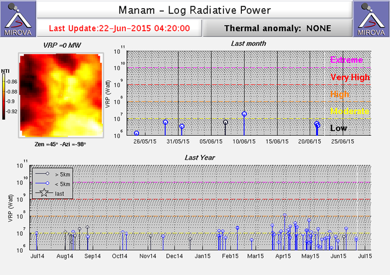 |
Figure 30. MIROVA Log VRP data for Manam from 22 June 2014 through 22 June 2015. Intermittent thermal anomalies are recorded at the end of June, early and late August, early October, and mid-November 2014. Thermal activity increased in frequency and intensity starting in the second half of January 2015. Courtesy of MIROVA. |
Activity during 2015. RVO noted incandescence from the Main Crater beginning on 19 January 2015, growing stronger during the last week of the month, matching observations in the MIROVA data (figure 30). A MODVOLC thermal alert pixel appeared on 23 January. Seismicity also changed after the middle of the month when RSAM values rose above 200 on 16 January and went as high as 500 on 31 January, after which they declined rapidly and remained low during February.
In February 2015, seismicity was characterized by small to moderate sub-continuous and continuous volcanic tremors. Increased incandescence was also evident from the Main Crater during February. RVO reported weak-to-bright steady incandescence during 7-10, 21, and 26 February. MODVOLC captured two thermal alert pixels on 8 February, and MIROVA reported an anomaly at the end of the first week and during the last week of the month. An ash plume was observed in satellite data by the Darwin VAAC on 24 February; the plume rose to 3 km altitude (1.2 km above the summit) and drifted 37 km W. RSAM values rising to 500 by 18 March led RVO to raise the Alert Level that day to Stage 2. Visual observations were difficult due to weather during much of the month, but MODVOLC reported thermal alert pixels on 19 and 26 March, and MIROVA captured several anomalies at the beginning of a period of increased frequency and intensity of thermal anomalies that lasted through mid-June (figure 30).
RVO reported that during April 2015 both craters released variable amounts of white vapor. Clearer skies revealed incandescence from the Southern Crater during nine nights of the month and seven times from the Main Crater. This is consistent with satellite thermal anomaly observations by MODVOLC on six different days, with four of them being multiple pixel alerts, and numerous anomalies captured by MIROVA. Two ash eruptions were reported by the Darwin VAAC on 27 and 30 April. The first low-level plume rose to 2.4 km and was observed in satellite imagery extending over 100 km to the W before dissipating on 28 April. The second plume was observed at the same altitude drifting 150 km NW. Seismicity remained high during April, still characterized by discreet small to moderate low-frequency earthquakes, and RSAM values ranged between 300 and 650, increasing during the month. Ground deformation GPS measurements at the end of April confirmed the continuing inflationary trend recorded by the electronic tiltmeters since the last measurements taken in May 2013 (figure 31).
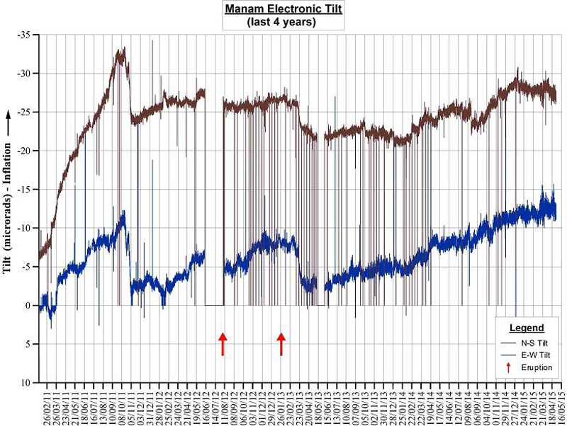 |
Figure 31. Electronic tilt measurements at Manam between 26 February 2011 and 1 May 2015 show a continuing inflationary trend. Eruptions in August 2012 and January 2013 are shown by red arrows. Courtesy of RVO (Volcano Information Bulletin 01-042015, 4 May 2015). |
Multiple sources of satellite data confirmed that Manam was active during May 2015. MODVOLC thermal alert pixels were reported from MODIS data captured on 6 and 22 May; MIROVA thermal anomalies were frequent. Ash plumes were reported from visible satellite imagery by the Darwin VAAC on 13 May at 3 km altitude drifting 37 km NE; SO2 plumes were captured by NASA's OMI instrument on the Aura satellite on 2, 12, 13, and 20 May (figure 32).
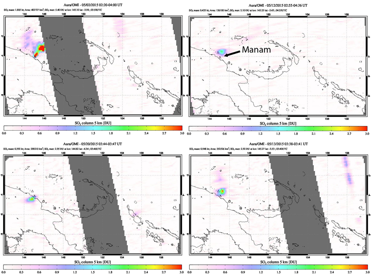 |
Figure 32. SO2 plumes captured by NASA's OMI instrument on the Aura satellite for Manam during May 2015. Clockwise from top left: 2 May, 12 May, 13 May, and 20 May. Missing data (gray stripes) are due to OMI row anomaly. Courtesy of NASA/GSFC. |
During June and early July 2015 there were four series of Volcanic Ash advisory reports from the Darwin VAAC. The first, on 21 and 22 June, reported a 3-km-altitude ash plume that extended over 35 km N and NW. The second, from 28 to 30 June, had altitudes that started at 2.4 and rose to 3 km, and drifted 75 km NE. A third plume emerged late on 30 June and lasted through 1 July, drifting 130 km E at 2.4 km altitude. A fourth plume reported on 2 July was confirmed by RVO as only a steam plume with no ash, and was seen in satellite imagery drifting 45 km E at 2.4 km altitude. A single MODVOLC thermal alert pixel was recorded on 7 July.
RVO reported a significant eruption on 31 July 2015 from the Southern Crater beginning about 1130 local time. They observed that low roaring noises marked the onset of the explosion followed by continuous ejection of scoria until about 1330. Fist-sized volcanic debris was reported at Warisi village on the E side of the island. At Baliau on the N side, clasts were about 10-20 cm in diameter. Two people were reportedly knocked unconscious from the falling scoria. Strong emissions of dark gray ash clouds followed the ejection of scoria and continued into the early afternoon. By 1740 emissions consisted of light gray ash clouds. The news source One Papua New Guinea reported that fine ash began to fall over Bogia (25 km SW on the mainland) around 1245 local time.
The ash plume was initially observed in satellite imagery by the Darwin VAAC at 19.8 km altitude spreading out in all direction for 100 km. It was captured by the Japanese Himawari-8 satellite (figure 33); an animation of the imagery showing the eruption was provided by Miller et al. (2016). Four hours later, the plume was visible 370 km to the SW. A lower-altitude ash plume at 6.7 km was observed the next day extending over 100 km SW. A significant SO2 plume was partially captured by the Aura instrument on the OMI satellite the next day, and measured an SO2 mass of 3.206 kilotons.
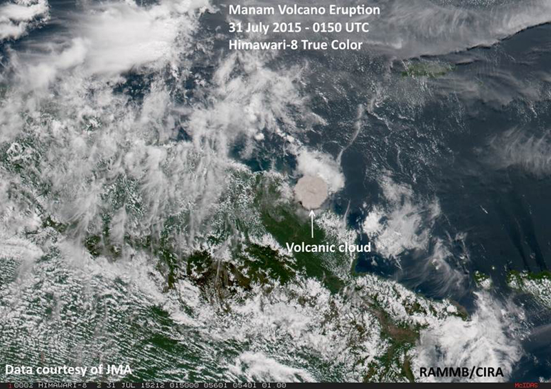 |
Figure 33. Ash cloud from Manam captured with True Color imagery by the Himawari-8 satellite on 31 July 2015 at 1150 local time, showing ash dispersing in all directions shortly after the explosion. Data courtesy of JMA (Japan Meteorological Agency), annotated image courtesy of RAMMB/CIRA (in Q4 report for 2015). An animation of the imagery showing the eruption is provided by Miller et al. (2016). |
The Darwin VAAC reported a new small ash plume on 6 August 2015 rising to 2.7 km drifting around 40 km to the NW, and another large ash plume on 8 August that initially rose to 6.4 km and drifted SSW. Pilots reported the ash at 5.8 km altitude about 90 km W of Kiunga Airport which is located 475 km SW of Manam. About 24 hours later, pilots reported another ash plume at 6 km altitude 150 km SE of the volcano. A hot spot was observed at the summit on 9 August; two MODVOLC thermal alert pixels appeared that day, and another one appeared on 15 August. A small plume was reported on 21 August, only rising to 2.1 km and drifting about 8 km ESE. This was followed two hours later by an ash plume observed 16 km NW at the same altitude, which continued to drift NW to 75 km before dissipating. Additional ash plumes were reported from 26-28 August rising to 2.4 km and drifting from 35 to 75 km, first NE, then N and NW; a small plume was reported on 31 August at 2.1 km drifting 75 km N before dissipating that day.
A single MODVOLC thermal alert pixel on 4 September was the last recorded in 2015. The next plume on 7 September was small, rising only to 2.1 km and drifting 75 km NW, briefly observed in one satellite before dissipating. It was a month until the next ash plume on 8 October 2015, when Darwin VAAC made a satellite observation of a plume at 1.8 km drifting 45 km NW. The last ash plume of 2015 was captured in satellite images on 29 October between 2.1 and 2.4 km altitude around 35 km NW.
Activity during 2016. The MIROVA data recorded thermal activity on about 29 January 2016 that increased in intensity and frequency in early March (figure 34). A small ash plume on 4 March rose to 3 km altitude and drifted about 90 km SE according to the Darwin VAAC. Increased thermal activity was recorded in MODVOLC thermal alert pixels and MIROVA data from early March through mid-July. There were no reports from the RVO during this time. The first MODVOLC alert was recorded on 7 March and they were persistent, almost every week, through the second week of July. On 13 July, an ash plume was observed by the Darwin VAAC in satellite imagery at 3 km altitude drifting 55 km W for a few hours before dissipating. After that, single-pixel MODVOLC thermal alerts were recorded on 20 September and 6 October. The MIROVA analysis of the MODIS data records a similar picture with a clear increase in the frequency and intensity of anomalies between early March and mid-July (figure 34); continuing pulses of thermal anomalies are present every month into January 2017.
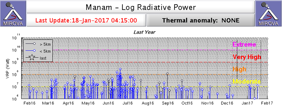 |
Figure 34. Log Radiative Power from MODIS thermal anomaly data recorded by MIROVA for Manam between 19 January 2016 and 18 January 2017. The increased frequency and intensity of thermal anomalies between early March and mid-July agrees well with other indicators of volcanic activity. Additionally, the MIROVA data suggests continued intermittent activity through 18 January 2017. Courtesy of MIROVA. |
Reference: Miller S D, Schmit T L, Seaman C J, Lindsey D T, Gunshor M M, Kohrs R A, Sumida Y, Hillger D, 2016, A Sight for Sore Eyes: The Return of True Color to Geostationary Satellites, Bulletin of the American Meteorological Society, vol. 97, no. 10. DOI: http://dx.doi.org/10.1175/BAMS-D-15-00154.1. Animated imagery of the 31 July 2015 eruption can be viewed at http://journals.ametsoc.org/doi/suppl/10.1175/BAMS-D-15-00154.1/suppl_file/10.1175_BAMS-D-15-00154.2.html .
Information Contacts: Rabaul Volcano Observatory (RVO), Geohazards Management Division, Department of Mineral Policy and Geohazards Management (DMPGM), PO Box 3386, Kokopo, East New Britain Province, Papua New Guinea; Darwin Volcanic Ash Advisory Centre (VAAC), Bureau of Meteorology, Northern Territory Regional Office, PO Box 40050, Casuarina, NT 0811, Australia (URL: http://www.bom.gov.au/info/vaac/); Hawai'i Institute of Geophysics and Planetology (HIGP), MODVOLC Thermal Alerts System, School of Ocean and Earth Science and Technology (SOEST), Univ. of Hawai'i, 2525 Correa Road, Honolulu, HI 96822, USA (URL: http://modis.higp.hawaii.edu/, http://modis.higp.hawaii.edu/); MIROVA (Middle InfraRed Observation of Volcanic Activity), a collaborative project between the Universities of Turin and Florence (Italy) supported by the Centre for Volcanic Risk of the Italian Civil Protection Department (URL: http://www.mirovaweb.it/); NASA Goddard Space Flight Center (NASA/GSFC), Global Sulfur Dioxide Monitoring Page, Atmospheric Chemistry and Dynamics Laboratory, Goddard, Maryland, USA (URL: https://so2.gsfc.nasa.gov/); Regional and Mesoscale Meteorology Branch (RAMMB) / Cooperative Institute for Research in the Atmosphere (CIRA), NOAA/NESDIS, Colorado State University, Fort Collins, CO 80523-1375, USA (URL: http://rammb.cira.colostate.edu/); One Papua New Guinea (URL: http://www.onepng.com/2015/07/manam-volcano-erupts.html).
Ash plumes and Strombolian explosions increase, March-May 2017
Manam is a basaltic-andesitic stratovolcano that lies 13 km off the northern coast of mainland Papua New Guinea; it has a 400-year history of recorded evidence for recurring low-level ash plumes and occasional Strombolian emissions, lava flows, pyroclastic avalanches, and large ash plumes. Activity during 2016 included only two episodes of ash emissions, during early March and mid-July, but persistent thermal activity (strongest between March and July 2016) was intermittent throughout the year (BGVN 42:03). Activity from January 2017-January 2018, discussed below, included increased Strombolian activity, lava flows, and ash emissions during February-May 2017 that led to evacuations and concern for local residents. Information about Manam is primarily provided by Papua New Guinea's Rabaul Volcano Observatory (RVO), part of the Department of Mineral Policy and Geohazards Management (DMPGM). This information is supplemented with aviation alerts from the Darwin Volcanic Ash Advisory Center (VAAC). MODIS thermal anomaly satellite data is recorded by the University of Hawai'i's MODVOLC thermal alert recording system, and the Italian MIROVA project; sulfur dioxide monitoring is done by instruments on satellites managed by NASA's Goddard Space Flight Center.
Summary of 2017 activity. A strong surge in thermal activity beginning in mid-February 2017 lasted through mid-June. Low levels of intermittent activity continued for the rest of 2017, with a short-lived increase during late December 2017 and early January 2018 (figure 35). Strong multi-pixel daily MODVOLC thermal alerts began on 17 February and continued through 29 May 2017. Plumes of SO2 were detected with satellite instruments in late February, early March, and during the second half of May.
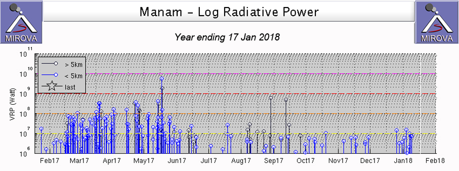 |
Figure 35. The MIROVA project Log Radiative Power signal for Manam increased significantly during late February 2017 and remained elevated through mid-June. Significant ash plumes and Strombolian activity were reported from early March-late May, after which only a few low-level ash plumes were reported through the end of 2017. Log Radiative Power graph of the year ending 17 January 2018. The occasional points shown in black indicate thermal sources located more than 5 km from the summit, and are likely unrelated to volcanic activity. Courtesy of MIROVA. |
The first report of ash emissions in 2017 was on 2 March. Activity increased in late March, and again during the second half of April. Most of the many ash plume events that took place during May rose to 2-5 km altitude, but on 4 and 26 May they rose to over 12 km altitude. Ash plumes were noted on only two days during June, and none during July. Minor low-level ash emissions resumed in early and mid-August. The final VAAC report of 2017 was issued on 2 September.
RVO reported incandescent activity, Strombolian explosions, lava and pyroclastic flows, and ash emissions during February-May 2017 from both the Main and Southern craters (figures 36 and 37), and steam-and-gas emissions throughout the year. Activity during late February to mid-April occurred at both craters; most of the activity during late April and May came from Southern Crater. The events of mid-May caused ashfall across the island. Lava flows and pyroclastic flows in mid-April and mid-May led to evacuations from several villages. Incandescence was observed once from Southern Crater in November and once from Main Crater in December.
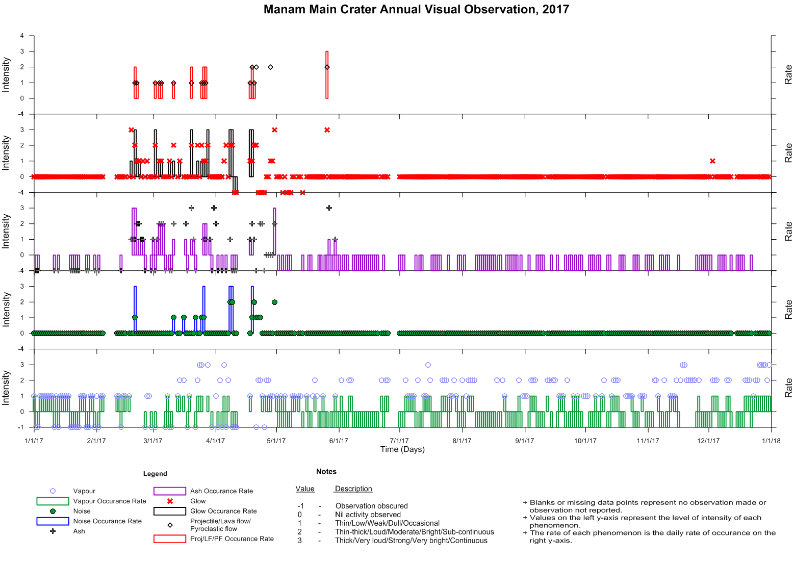 |
Figure 36. Activity at Main Crater of Manam during 2017. The five graphs represent the rate (right y-axis) and intensity (left y-axis) of various activity at the volcano. Steam-and-gas emissions were observed throughout the year (bottom graph; green bars, blue circles). Explosions were heard during mid-February-April (second from bottom graph; blue bars, green circles). Ash emissions were reported from mid-February through April, and at the end of May (middle graph; purple bars, black crosses). Incandescence was observed from mid-February-April, once at the end of May and once in early December (second from top graph; black bars, red x's). Incandescent bombs, lava flows or pyroclastic flows were observed during mid-February-April and at the end of May (top graph; red bars, black diamonds). Courtesy of Steve Saunders, RVO. |
 |
Figure 37. Activity at Southern Crater of Manam during 2017. The five graphs represent the rate (right y-axis) and intensity (left y-axis) of various activity at the volcano. Steam-and-gas emissions were observed throughout the year (bottom graph; green bars, blue circles). Explosions were heard during February-May and in mid-July (second from bottom graph; blue bars, green circles). Ash emissions were reported from mid-January through May (middle graph; purple bars, black crosses). Incandescence was observed in early January, from late January-May, and once in early November (second from top graph; black bars, red x's). Incandescent bombs, lava flows, or pyroclastic flows were observed from mid-February-mid May (top graph; red bars, black diamonds). Courtesy of Steve Saunders, RVO. |
Activity during February-March 2017. After a break during much of December 2016, low-to-moderate pulses of thermal anomalies were recorded briefly by the MIROVA project early in January 2017 (BGVN 42:03, figure 34). Activity increased again in mid-February with stronger MIROVA anomalies and multi-pixel MODVOLC thermal alerts. Sulfur dioxide plumes were released on 25 February and 4 March 2017 (figure 38).
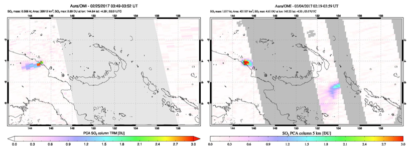 |
Figure 38. Sulfur dioxide emissions from Manam increased in late February 2017 along with increased thermal activity. SO2 plumes were captured by the OMI instrument on the Aura satellite on 25 February 2017 (left) and 4 March 2017 (right). Another emission, partly obscured, on 4 March is likely from Bagana on Bougainville Island to the SE. Courtesy of NASA Goddard Space Flight Center. |
MODVOLC thermal alerts were issued on 13 days during March, many days had 3-6 alerts. The Darwin VAAC issued the first Volcanic Ash Advisory of 2017 on 2 March based on a pilot report of ash extending N of the volcano at 3 km altitude. The next report, on 20 March, indicated an ash plume visible in satellite imagery moving NE at 2.4 km altitude. It extended 80 km E of the summit the following day. Mostly-steam emissions with minor ash content were reported on 23 March, extending 75 km SE at the same altitude.
Activity during April 2017. Intense multi-pixel MODVOLC thermal alerts continued into April 2017; days with multiple alerts included 2, 14, 22-23, and 25-26 April. RVO released a Volcano Information Bulletin on 16 April 2017 noting a sudden increase in RSAM values beginning on 15 April, and indicating that a small-to-moderate eruption was ongoing from Main Crater. Incandescence was visible during most nights of April from both Main and Southern craters. RSAM values increased by two orders of magnitude during 16-17 April (figure 39). During that night, a brief report from Dugulava village on the SE side of the island indicated that large incandescent lava fragments were falling into valleys to the N and SW, accompanied by loud explosions. Strombolian activity at Southern Crater increased on 18 April, and was accompanied by emissions of dark ash plumes that rose a few hundred meters above the crater and drifted NW. Two small pyroclastic flows were channeled into valleys on the SE and SW flanks, and terminated at about 1,000 m elevation. Strombolian activity subsided by late afternoon, but weak gray ash emissions continued. At Main Crater, white-gray ash plumes continued with bursts of incandescence at about 5-minute intervals.
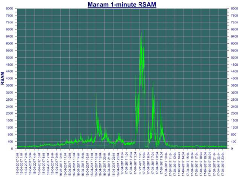 |
Figure 39. A spike in RSAM values during 16-17 April 2017 coincided with increased Strombolian activity from Southern Crater at the summit of Manam. Courtesy of RVO-DMPGM (Volcano Information Bulletin-No. 06-042017, Issue Date: 19th April 2017). |
RVO reported that activity diminished after 18 April but continued at low levels through 21 April; explosions were still heard from both Main and Southern Craters. Both craters were incandescent, but only Southern Crater ejected incandescent tephra, which became briefly intense during the morning of 20 April. Pale gray-to-brown plumes containing minor amounts of ash rose from both craters and drifted SE. RSAM values began to rise again on 22 April, and Strombolian activity continued during 22-24 April (figure 40). According to a news article from 25 April (The National) the Alert Level was raised to Stage 3, and an official on the island noted that evacuations of women and children had begun to Bogia, about 16 km SW on the mainland.
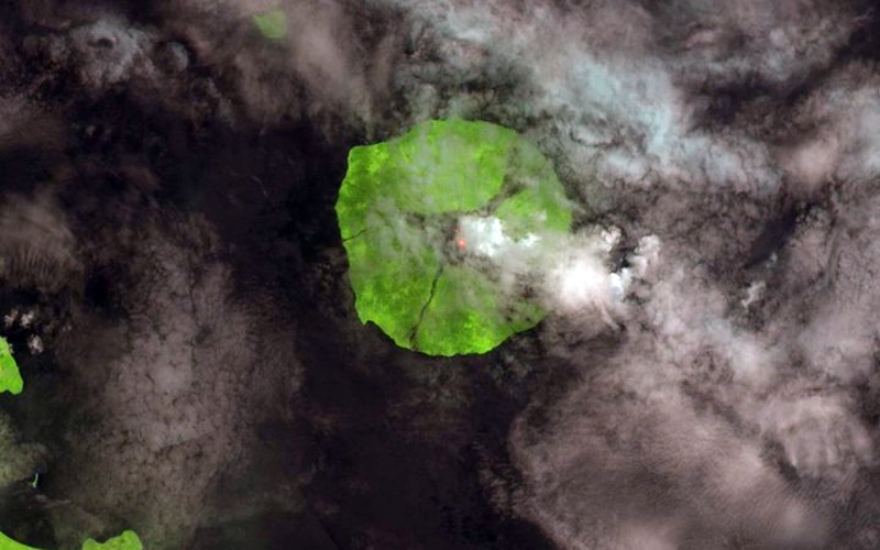 |
Figure 40. An explosion at Manam on 22 April 2017. Incandescence at the summit and steam emissions are visible beneath the meteoric clouds. Photo: USGS/Landsat-8 OLI. Courtesy of Radio New Zealand. |
The Darwin VAAC reported an ash plume at 4.6 km altitude extending about 35 km SE from the summit on 24 April. The next day, an ash plume was observed drifting a similar distance SW at 3 km altitude. The drift direction changed to WSW then W during 26 April, and the plume was last observed about 65 km from the summit. Infrared imagery indicated ongoing activity at the summit.
Strombolian activity and strong, dark-gray ash emissions continued during 24-25 April; activity declined for a few days before the next pulse began during the early morning of 28 April with Strombolian explosions that were heard at the Bogia Government Station. Most of the lava fell back into the crater, but some traveled down the SW and SE valleys, and minor amounts of ash fell on the SE and W parts of the island.
A pulse of moderately-high Strombolian activity occurred from Southern Crater during the early morning of 30 April 2017. The episode lasted about two hours and produced a small pyroclastic flow that was channeled into the SW valley and stopped at about 200 m elevation. Ejected incandescent lava fragments landed mostly within the crater, but some traveled down the SW and SE valleys. Ash and scoria up to 40 mm in diameter fell on the E side of the island in Abaria and Boakure.
Activity during May 2017. The strongest thermal activity of the year was recorded during May 2017. MODVOLC thermal alerts were issued on 4, 5, 9, 13, 14, 17, 18, 25, and 29 May, with 21 alerts issued on 18 May and a single alert on 29 May that was the last issued for the year. RVO reported a Strombolian event from Southern Crater, lasting from about 1700 on 4 May to 0700 the following morning. A lava flow descended into the SW valley to 600 m above sea level, and minor amounts of ash fell in areas stretching between Warisi to the E, Dugulaba on the S, and Boda and Baliab on the NW parts of the island.
The Darwin VAAC reported an ash plume drifting E at 3 km altitude late on 4 May 2017 (UTC). About an hour later, they reported a much higher altitude ash plume moving S from the summit at 12.5 km altitude, in addition to continuous ash moving E at 3 km altitude. The high-level ash plume dissipated after about five hours, but the lower-level emission continued to be visible in satellite imagery drifting E, then NE at least 25 km from the summit through 7 May, after which activity subsided. RVO reported steam-and-gas emissions from Southern Crater on 13 May. Incandescent lava fragments were ejected during the early morning of 14 May, generating a lava flow that traveled down the SW valley to an elevation of 600-700 m.
The next VAAC report, on 14 May 2017, noted an ash plume drifting NW at 4.6 km altitude 35 km from the summit. Later in the day, they reported another short-lived ash plume that rose to 5.5 km altitude drifting almost 100 km W, and a large hotspot over the summit. The lower-altitude plume lasted for another day before dissipating. RVO reported light gray to dark gray ash plumes during 15-18 May. The Darwin VAAC reported multiple plumes moving W at 2.1-2.4 km altitude on 17 May, and continuous emissions extending WNW on 18 May. RVO reported explosive activity on 18 May; a small lava flow traveled down the SW valley, but not as far as the 13-14 May flow. A weak ash emission, which dissipated after a few hours, was reported on 19 May drifting W at 2.7 km altitude. The Darwin VAAC reported that a substantial ash emission on 26 May 2017 was seen in satellite images drifting 55-75 km W at 12.2 km altitude. A second plume from a continuous lower-level eruption was reported later in the day rising to 4.6 km altitude. Both plumes dissipated by the end of the day. Sulfur dioxide emissions were captured by satellite instruments on 18 and 27 May (figure 41).
 |
Figure 41. SO2 plumes from Manam were captured on 18 (left) and 27 (right) May 2017 by the OMI instrument on the Aura satellite. Eruptive activity was reported by RVO and ash emissions were reported by the Darwin VAAC on 18 May, and a large ash emission was reported by the Darwin VAAC on 26 May. Courtesy of NASA Goddard Space Flight Center. |
Activity during June-December 2017. Activity decreased significantly after May 2017 and was low for the remainder of the year. RVO noted weak-to-moderate steam plumes on the rare clear-weather days during June; there was no observed incandescence, and very low seismicity. The Darwin VAAC reported an ash plume that rose to 5.5 km altitude and drifted W on 6 June. Later in the day the plume extended WNW at about 2.4 km altitude. It was last observed early on 7 June before dissipating. No further ash emissions were noted by the Darwin VAAC or RVO until 5 August 2017 when the Darwin VAAC observed minor ash emissions moving NW at 2.1 km altitude. The emissions were visible that day and the next before dissipating. A new ash emission was reported late on 7 August, drifting W at 1.8 km altitude for about 8 hours before dissipating early the next day. Another minor plume on 12 August briefly extended 35 km NW at 2.1 km altitude. During 21-22 August, a similar plume was seen at the same altitude. A minor ash emission on 1 September, which also rose to 2.1 km altitude, was only visible for a few hours before dissipating, and was the last emission reported in 2017.
RVO noted incandescence at Southern Crater once in early November, and once at Main Crater in early December. The MIROVA data showed a cluster of thermal anomalies during late December2017 and early January 2018 (figure 35) suggesting a renewed pulse of thermal activity during that time.
Information Contacts: Rabaul Volcano Observatory (RVO), Geohazards Management Division, Department of Mineral Policy and Geohazards Management (DMPGM), PO Box 3386, Kokopo, East New Britain Province, Papua New Guinea; Darwin Volcanic Ash Advisory Centre (VAAC), Bureau of Meteorology, Northern Territory Regional Office, PO Box 40050, Casuarina, NT 0811, Australia (URL: http://www.bom.gov.au/info/vaac/); MIROVA (Middle InfraRed Observation of Volcanic Activity), a collaborative project between the Universities of Turin and Florence (Italy) supported by the Centre for Volcanic Risk of the Italian Civil Protection Department (URL: http://www.mirovaweb.it/); Hawai'i Institute of Geophysics and Planetology (HIGP) - MODVOLC Thermal Alerts System, School of Ocean and Earth Science and Technology (SOEST), Univ. of Hawai'i, 2525 Correa Road, Honolulu, HI 96822, USA (URL: http://modis.higp.hawaii.edu/); NASA Goddard Space Flight Center (NASA/GSFC), Global Sulfur Dioxide Monitoring Page, Atmospheric Chemistry and Dynamics Laboratory, 8800 Greenbelt Road, Goddard, Maryland, USA (URL: https://so2.gsfc.nasa.gov/); Radio New Zealand (URL: http://www.radionz.co.nz); The National (URL: http://www.thenational.com.pg).
Ash plumes reaching 15 km altitude in August and December 2018
Manam is a basaltic-andesitic stratovolcano that lies 13 km off the northern coast of mainland Papua New Guinea; it has a 400-year history of recorded evidence for recurring low-level ash plumes, occasional Strombolian activity, lava flows, pyroclastic avalanches, and large ash plumes. Activity during 2017 included a strong surge in thermal anomalies beginning in mid-February that lasted through mid-June; low levels of intermittent thermal activity continued for the rest of the year (BGVN 43:03). Activity during 2018, discussed below, included two ash explosions that rose higher than 15 km altitude, in August and December, resulting in significant ashfall and evacuations of several villages. Information about Manam is primarily provided by Papua New Guinea's Rabaul Volcano Observatory (RVO), part of the Department of Mineral Policy and Geohazards Management (DMPGM). This information is supplemented with aviation alerts from the Darwin Volcanic Ash Advisory Center (VAAC). MODIS thermal anomaly satellite data is recorded by the University of Hawai'i's MODVOLC thermal alert recording system, and the Italian MIROVA project; sulfur dioxide monitoring is done by instruments on satellites managed by NASA's Goddard Space Flight Center. Satellite imagery provided by the Sentinel Hub Playground is also a valuable resource for information about this remote location.
Satellite imagery confirmed thermal activity in December 2017, February-April 2018, and June-December 2018. Explosive activity with ash plumes was reported in June, August-October, and December 2018. Ash plumes from explosions in late August and early December rose to over 15 km altitude and caused heavy ashfall on the island. Lava flows were reported in late August, late September to early October, and December; a pyroclastic flow on the NE flank occurred during the late August explosive episode. MODVOLC thermal alerts were issued during the same periods when lava flows were reported on the NE flank. The MIROVA Log Radiative Power graph for 2018 showed intermittent pulses of thermal activity throughout the year; levels of increased activity were apparent in late December 2017-early January 2018, mid-May, August, late September-early October, and early December 2018 (figure 42). Many of these thermal events could be confirmed with either satellite or ground-based information.
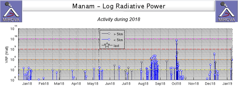 |
Figure 42. The MIROVA Log Radiative Power graph for Manam during 2018 showed intermittent pulses of thermal activity throughout the year, many of which could be confirmed with satellite imagery or ground observations. Levels of increased activity were apparent in late December 2017-early January 2018, mid-May, August, late September to early October, and the first half of December 2018. Courtesy of MIROVA. |
Activity during December 2017-July 2018. Both Sentinel-2 satellite imagery, and MIROVA data thermal evidence, indicated continued thermal activity at both of Manam's summit craters (Main and Southern) during December 2017-April 2018. Satellite imagery on 11, 26, and 31 December showed two thermal hotspots on each date, with a gas plume drifting E on 26 December 2017. One strong thermal anomaly was visible in satellite imagery on 19 February 2018 along with a SE-drifting gas plume (figure 43). A single anomaly was visible through atmospheric clouds on 1 March 2017 with a thin gas plume drifting NNE. On 10 April two hotspots were clearly visible, the one at Southern Crater was larger than the one at Main Crater, both with ESE drifting gas plumes. Though there was diffuse atmospheric cloud cover on 15 April, both anomalies were visible with SW-drifting gas plumes. On 25 April clouds covered the likely thermal anomalies, but a dense gas plume drifted N from the summit (figure 44).
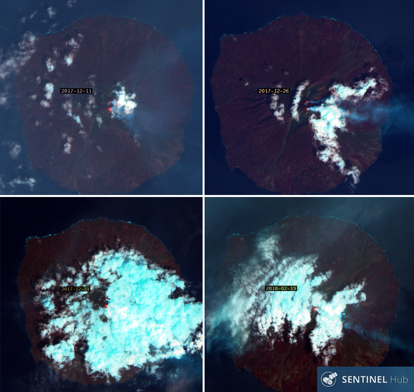 |
Figure 43. Sentinel-2 images (bands 12, 14, 2) of Manam on 11, 26, and 31 December 2017 and 19 February 2018 all showed evidence of either one or two thermal anomalies at the summit craters and gas plumes drifting in multiple directions. Courtesy of Sentinel Hub Playground. |
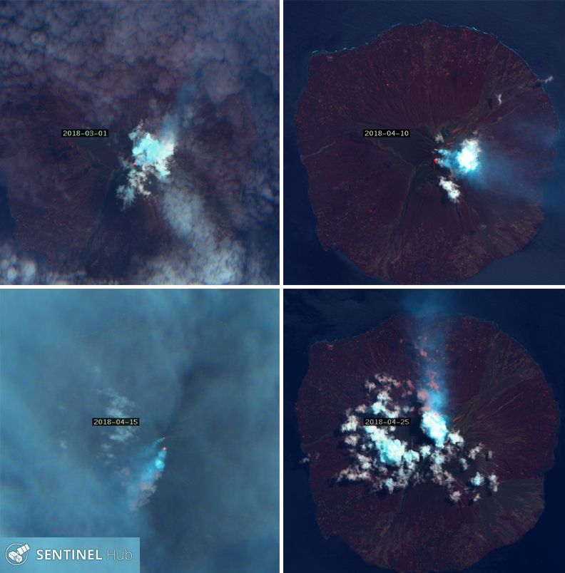 |
Figure 44. Thermal anomalies and/or gas plumes were visible at Manam's Main and Southern Craters on 1 March and 10, 15, and 25 April 2018 in Sentinel-2 imagery (bands 12, 14, 2), confirming continued activity at the volcano. Courtesy of Sentinel Hub Playground. |
Although no satellite images confirmed thermal activity in May 2018, several anomalies were recorded by the MIROVA project (figure 42). Sentinel-2 imagery on 9 June confirmed two hotspots at the summit with Southern Crater's signal larger than the weak Main Crater signal; the first VAAC report of 2018 was issued on 10 June based on a pilot report of ash at 1.8 km altitude, but it did not appear in satellite imagery. Two thermal anomalies were both more clearly visible on 29 July, with NNE drifting gas plumes (figure 45).
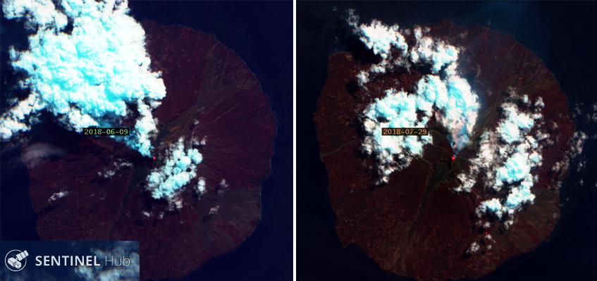 |
Figure 45. Two thermal anomalies with steam and gas plumes were visible in Sentinel-2 imagery (bands 12,4, 2) at the summit of Manam on 9 June and 29 July 2018. Courtesy of Sentinel Hub Playground. |
Activity during August 2018. Thermal activity began increasing in early August 2018, as seen in the MIROVA data, but satellite imagery also indicated a growing hotspot at Main Crater on 13 August. The thermal source appeared to be some type of incandescent flow on the upper NE flank that was visible in 23 August imagery along with the second anomaly at Southern Crater (figure 46).
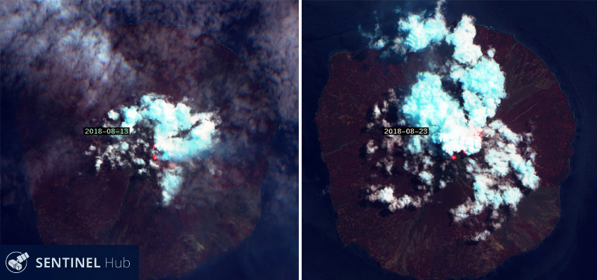 |
Figure 46. Growing hotspots were visible at the summit of Manam in Sentinel-2 imagery (bands 12,4, 2) on 13 August 2018 compared with the June and July imagery (figure 45). By 23 August a much larger thermal anomaly was visible beneath cloud cover originating from Main Crater. Courtesy of Sentinel Hub Playground. |
The Rabaul Volcano Observatory (RVO) issued an information bulletin early on 25 August indicating a new eruption from Main Crater (figure 47). Residents on the island reported increased activity around 0500 local time. The Darwin VAAC also issued a report a few hours later (24 August 2019 UTC) where they increased the Aviation Color code to Red, and indicated a high-impact eruption with an ash plume visible in satellite imagery that rose to 15.2 km altitude and drifted WSW after initially moving N (figure 48). Reports received at RVO indicated that ash, scoria, and mud fell in areas between the communities of Dangale on the NNE and Jogari on the SW part of the island. They also indicated that the most affected areas were Baliau and Kuluguma where wet, heavy, ashfall broke tree branches and reduced visibility (figure 49). A lava flow was observed in the NE valley slowly moving downhill, and there was evidence of a pyroclastic flow that reached the ocean in the same valley (figure 50).
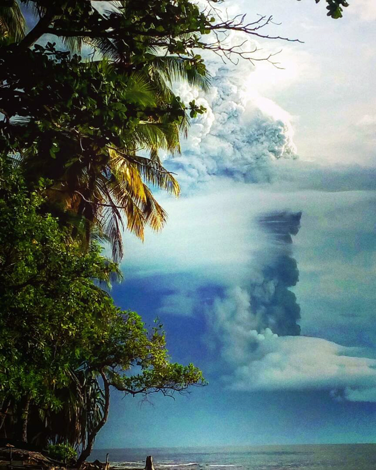 |
Figure 47. A large explosion at Manam on 25 August 2018 (local time) produced an ash plume that rose to over 15 km altitude. Islanders reported that ash and other debris from the eruption was so thick that sunlight was totally blocked for hours. Photo taken from the New Guinea mainland by members of the Police force. Courtesy of Scott Waide. |
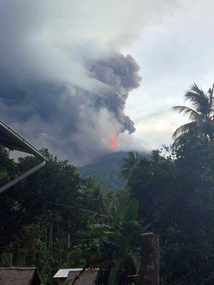 |
Figure 48. A substantial ash plume from an explosion at Manam on 25 August 2018 (local time) rose to 15.2 km altitude and drifted WSW for about five hours. Photo by Sean Richards, courtesy of Scott Waide. |
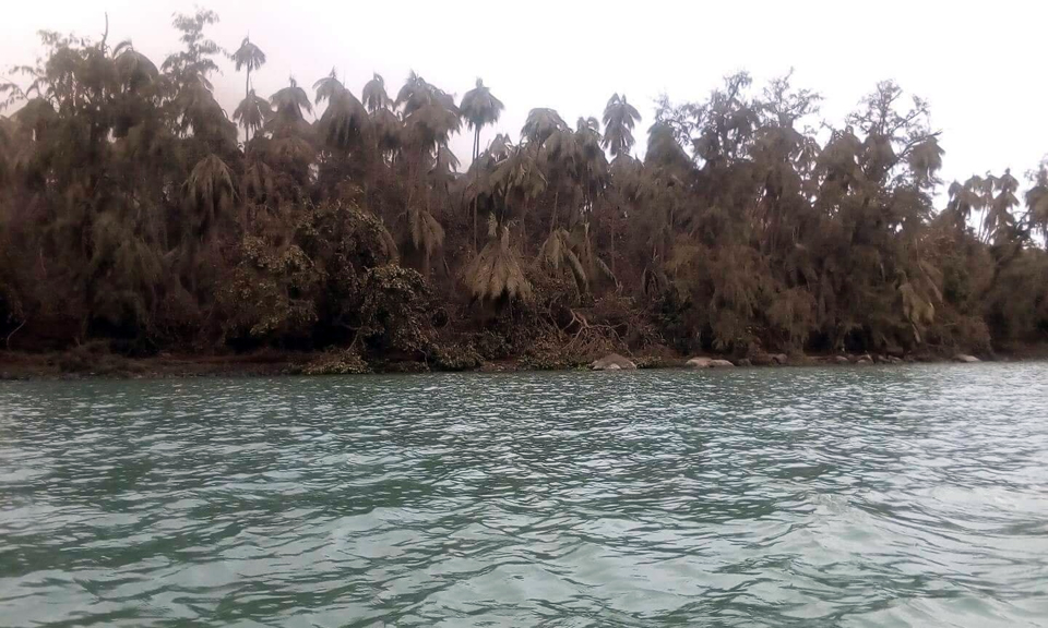 |
Figure 49. Vegetation on Manam was covered and damaged by heavy, wet, ash after an explosion on 25 August 2018. Photo by Anisah Isimel, courtesy of Scott Waide. |
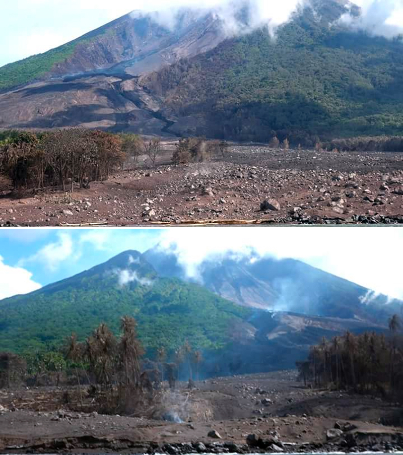 |
Figure 50. A fresh lava flow was visible in the major drainage on the NE flank at Manam a few days after a large explosion on 25 August 2018. Pyroclastic flows scorched trees and left behind debris. Posted online on 28 August 2018 by journalist Scott Waide from an article by journalist Martha Louis, EMTV. |
The eruption ceased around 1030 local time and was followed by dense steam plumes rising from the summit. RVO reported the following day that six houses in Boakure village on the NE side of the island were buried by debris from the pyroclastic flow. The occupants of the houses had escaped earlier to nearby Abaria village and no casualties were reported. The OMI instrument on NASA's Aura satellite captured a significant SO2 plume drifting WSW a few hours after reports of the 25 August eruption (figure 51). The Darwin VAAC reported a possible ash eruption on 28 August that was drifting WNW at 3.4 km altitude for a brief period before dissipating. According to RVO, several mudflows were reported in areas between the NW and SW parts of the island after the 25 August 2018 eruption, triggered by the heavy rainfall that followed.
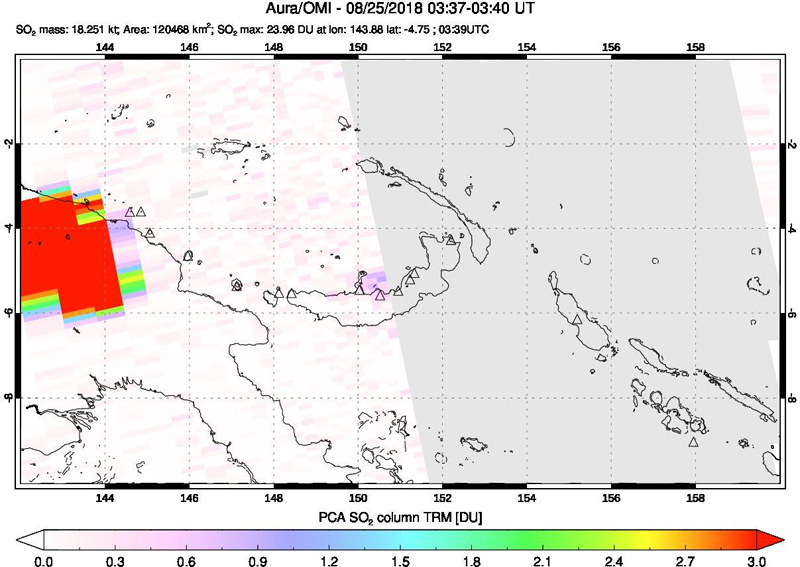 |
Figure 51. The OMI instrument on NASA's Aura satellite captured a significant SO2 plume drifting WSW from Manam a few hours after reports of the 25 August 2018 eruption. Courtesy of NASA Goddard Space Flight Center. |
Activity during September-November 2018. Satellite evidence during September 2018 confirmed the ongoing activity at the summit where a thermal anomaly was visible at Southern Crater on 7 September. On 12 September a gas plume drifted NW from the thermal anomaly at Southern crater while an incandescent lava flow was visible on the NE flank below Main Crater. (figure 52). RVO reported increased activity at Southern Crater during 20-24 September that included variable amounts of steam and gray to brown ash plumes. The Darwin VAAC reported a short-lived ash plume visible in satellite imagery on 23 September that rose to 8.5 km altitude and drifted NW. A small ash emission seen in visible imagery on 25 September rose to 2.4 km altitude and extended SE briefly before dissipating. Although partially obscured by clouds, the lava flow was still visible on the upper NE flank on 27 September (figure 52).
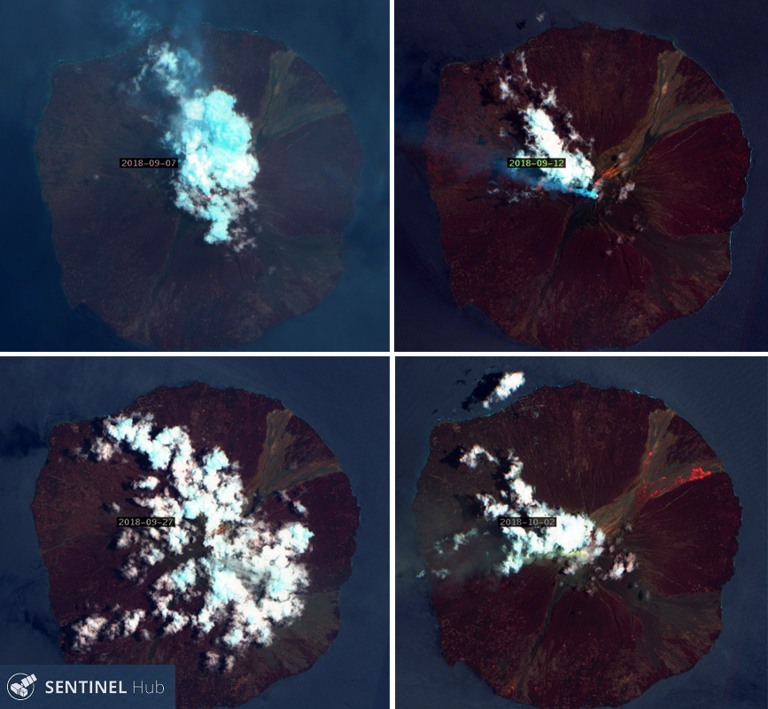 |
Figure 52. Satellite evidence (Sentinel-2, bands 12, 4, 2) during September 2018 at Manam confirmed the ongoing activity at the summit where a thermal anomaly was visible at Southern Crater on 7 September. On 12 September a gas plume drifted NW from Southern Crater while an incandescent flow traveled down the NE flank from Main Crater. Although partially obscured by clouds, the flow was still visible on the upper NE flank on 27 September. A nearly clear satellite image on 2 October showed incandescent lava reaching almost to the ocean in two lobes on the NE flank of the island. Courtesy of Sentinel Hub playground. |
Continuous ash emissions from a new explosion were first reported based on satellite imagery by the Darwin VAAC on 30 September (UTC) at 4.3 km altitude extending SW, and also at 3.0 km altitude drifting W. The emissions at 4.3 km altitude dissipated the following day, but lower level emissions continued at 2.1 km altitude drifting NW through 3 October. On 1 October residents reported hearing continuous loud roaring, rumbling, and banging noises, and reports from Tabele on the SW side of the island indicated very bright incandescence at the summit area. The incandescence was also visible from the Bogia Government Station on the mainland. Small amounts of fine ash and scoria were reported at Jogari and surrounding villages to the N on 1 October. Field observations on 1 October confirmed the presence of a two-lobed lava flow into the NE valley. The smaller lobe traveled towards Kolang village on the N side of the valley and the larger lobe went to the S towards Boakure village. Both flows stopped before reaching inhabited areas. A nearly clear satellite image on 2 October showed the incandescent lava reaching almost to the ocean in the two lobes on the NE flank of the island (figure 52). An SO2 plume drifting SW from Manam was captured by the OMI instrument on the Aura satellite on 1 October 2018 (figure 53).
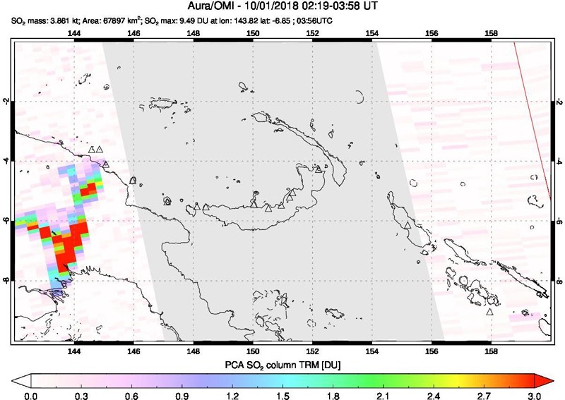 |
Figure 53. The OMI instrument on NASA's Aura satellite captured an SO2 plume drifting SW from Manam on 1 October 2018. Courtesy of NASA Goddard Space Flight Center. |
RVO reported that during 2-12 October Southern Crater produced variable amounts of brown, gray-brown and dark gray ash clouds that rose between a few hundred meters and a kilometer above the summit craters before drifting NW. The Darwin VAAC reported an ash emission to 10.4 km altitude on 5 October that extended 25 km W before dissipating within a few hours. Continuous emissions to 2.4 km altitude extending WNW began a few hours later and were intermittently visible in satellite imagery through 12 October. Incandescent lava was visible in satellite imagery on the NE flank on 12 October (figure 54). Activity decreased significantly during the rest of October and most of November 2018, with no ground reports, VAAC reports, or satellite imagery indicating thermal activity; only the MIROVA data showed low-level thermal anomalies (figure 42). A satellite image on 26 November 2018 indicated that thermal activity continued at one of the summit craters (figure 54).
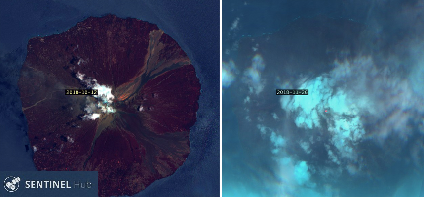 |
Figure 54. Incandescent lava was visible on the NE flank of Manam on 12 October 2018 in this Sentinel-2 satellite image (bands 12, 4, 2). A single hotspot appeared through meteoric clouds on 26 November. Courtesy of Sentinel Hub Playground. |
Activity during December 2018. The Darwin VAAC reported a minor ash emission on 6 December 2018 that rose to 5.2 km altitude and drifted SE for a few hours before dissipating. A much larger ash emission on 8 December was clearly observed in satellite imagery and reported by a pilot, as well as by ground and ocean-based observers. It was initially reported at 12.2 km altitude but rose to 15.2 km a few hours later, drifting E for about 10 hours before dissipating (figure 55). This was followed later in the day by an ongoing ash emission at 8.2 km altitude that drifted E before dissipating on 9 December. According to the UNHCR news organization Relief Web, the eruption started around 1300 local time on 8 December and lasted until about 1000 on 9 December. Based on reports from the ground, the eruption affected the NE part of the island. In particular, a lava flow affected Bokure (Bokuri) and Kolang (NE Manam). Communities in both localities were evacuated. The Loop PNG reported that RVO noted that the flow stopped before reaching Bokure. Ash and scoria fall was described as being moderate in downwind areas, including Warisi village on the SE side of the island. An SO2 plume was also identified by satellite instruments. Hotspots were visible from both craters on 11 December and from one of the craters on 16 December (figure 56).
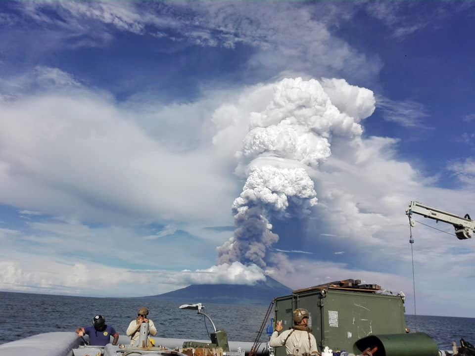 |
Figure 55. This image of an eruption at Manam on 8 December 2018 (local time) was likely taken from a Papua New Guinea government ship, and made available via Jhay Mawengu of the Royal Papua New Guinea Constabulary. |
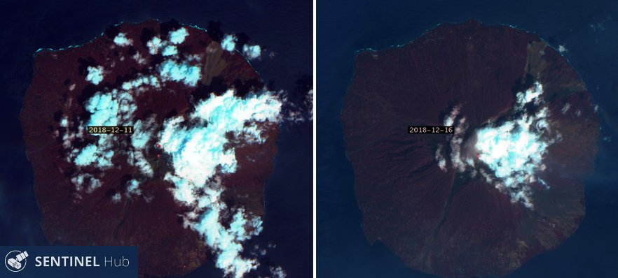 |
Figure 56. Sentinel-2 satellite images indicated thermal activity continuing as hotspots at the summit of Manam on 11 and 16 December 2018. Courtesy of Sentinel Hub Playground. |
Information Contacts: Rabaul Volcano Observatory (RVO), Geohazards Management Division, Department of Mineral Policy and Geohazards Management (DMPGM), PO Box 3386, Kokopo, East New Britain Province, Papua New Guinea; Hawai'i Institute of Geophysics and Planetology (HIGP) - MODVOLC Thermal Alerts System, School of Ocean and Earth Science and Technology (SOEST), Univ. of Hawai'i, 2525 Correa Road, Honolulu, HI 96822, USA (URL: http://modis.higp.hawaii.edu/); MIROVA (Middle InfraRed Observation of Volcanic Activity), a collaborative project between the Universities of Turin and Florence (Italy) supported by the Centre for Volcanic Risk of the Italian Civil Protection Department (URL: http://www.mirovaweb.it/); Sentinel Hub Playground (URL: https://www.sentinel-hub.com/explore/sentinel-playground); NASA Goddard Space Flight Center (NASA/GSFC), Global Sulfur Dioxide Monitoring Page, Atmospheric Chemistry and Dynamics Laboratory, 8800 Greenbelt Road, Goddard, Maryland, USA (URL: https://SO2.gsfc.nasa.gov/); Scott Waide (URL: https://mylandmycountry.wordpress.com/2018/08/, Twitter: @Scott_Waide); Jhay Mawengu, Royal Papua New Guinea Constabulary (URL: https://www.facebook.com/mawengu.jeremy.7); Relief Web, United Nations Office for the Coordination of Humanitarian Affairs, Resident Coordinator's Office, 380 Madison Avenue, 7th floor, New York, NY 10017-2528, USA (URL: https://reliefweb.int/); LOOP Pacific (URL: http://www.looppng.com/).
Significant eruption on 28 June produced an ash plume up to 15.2 km and pyroclastic flows
Manam is a frequently active volcano forming an island approximately 10 km wide, located 13 km north of the main island of Papua New Guinea. At the summit are the Main Crater and South Crater, with four valleys down the NE, SE, SW, and NW flanks (figure 57). Recent activity has occurred at both summit craters and has included gas and ash plumes, lava flows, and pyroclastic flows. Activity in December 2018 prompted the evacuation of nearby villages and the last reported activity for 2018 was ashfall on 8 December. Activity from January through September 2019 summarized below is based on information from the Rabaul Volcano Observatory (RVO), the Darwin Volcanic Ash Advisory Center (VAAC), the University of Hawai'i's MODVOLC thermal alert system, Sentinel-5P/TROPOMI and NASA Aqua/AIRS SO2 data, MIROVA thermal data, Sentinel-2 satellite images, and observations by visiting scientists. A significant eruption in June resulted in evacuations, airport closure, and damage to local crops and infrastructure.
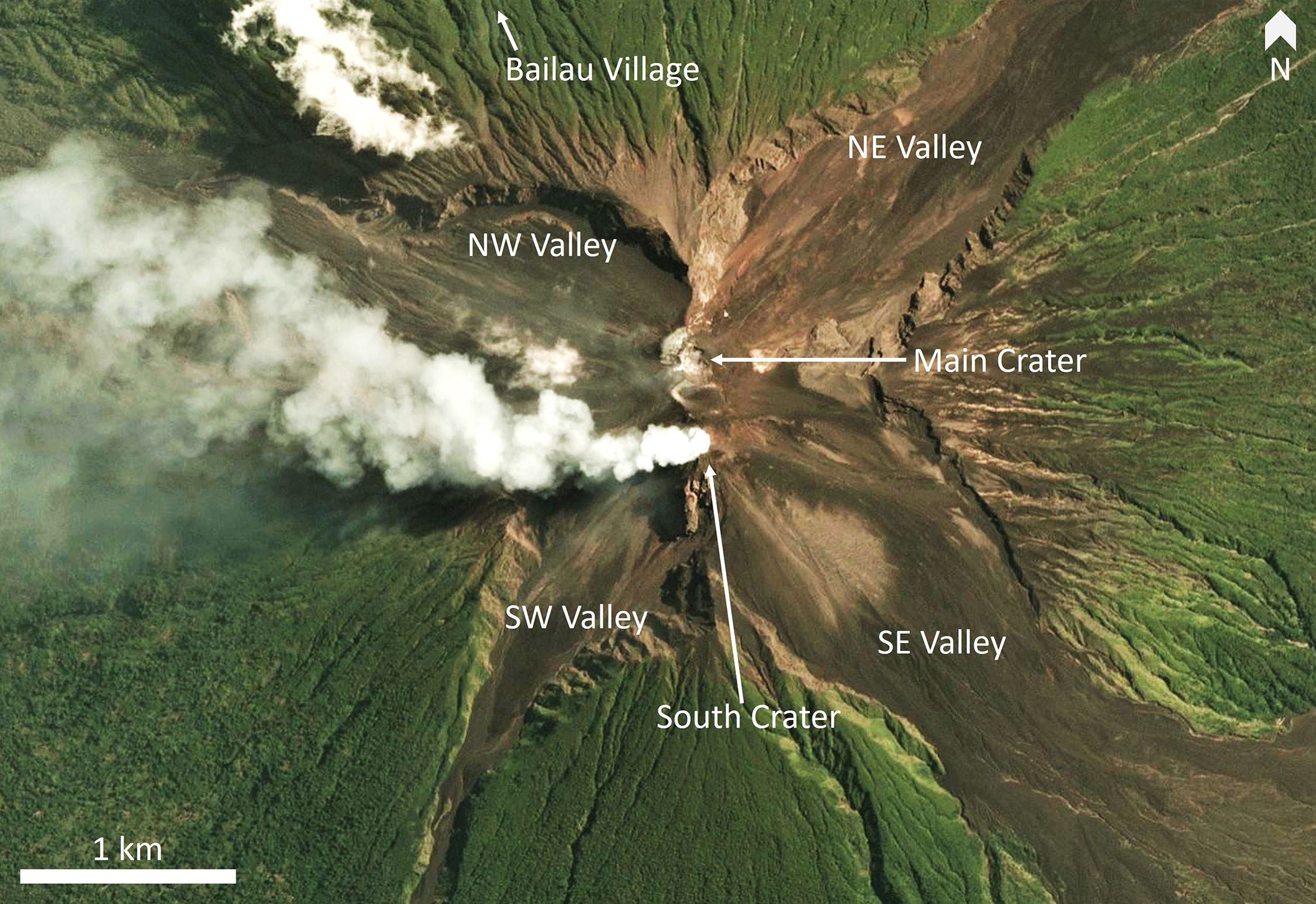 |
Figure 57. A PlanetScope image of Manam showing the two active craters with a plume emanating from the South Crater and the four valleys at the summit on 29 August 2019. Image copyright 2019 Planet Labs, Inc. |
Activity during January-May 2019. Several explosive eruptions occurred during January 2019 according to Darwin VAAC reports, including an ash plume that rose to around 15 km and dispersed to the W on the 7th. RVO reported that an increase in seismic activity triggered the warning system shortly before the eruption commenced (figure 58). Small explosions were observed through to the next day with ongoing activity from the Main Crater and a lava flow in the NE valley observed from around 0400. Intermittent explosions ejected scoria after 0600, depositing ejecta up to 2 cm in diameter in two villages on the SE side of the island. Incandescence at both summit craters and hot deposits at the terminus of the NE valley are visible in Sentinel-2 TIR data acquired on the 10th (figure 59).
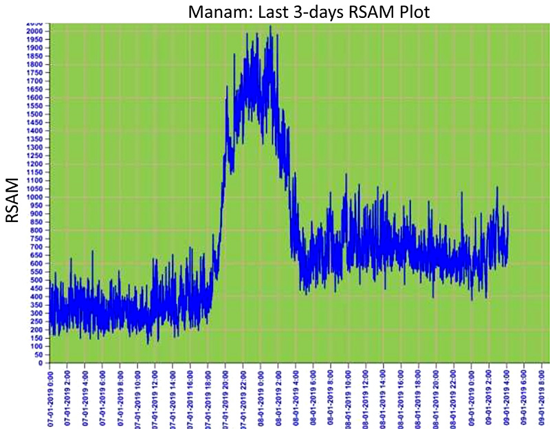 |
Figure 58. Real-Time Seismic-Amplitude Measurement graph representing seismicity at Manam over 7-9 January 2019, showing the increase during the 7-8 January event. Courtesy of RVO. |
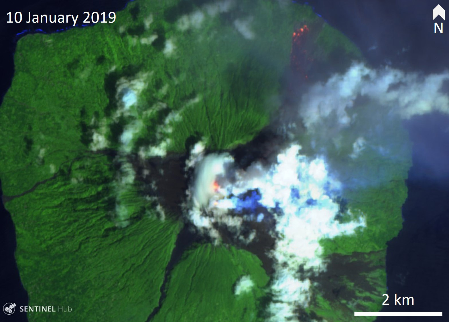 |
Figure 59. Sentinel-2 thermal infrared (TIR) imagery shows incandescence in the two Manam summit craters and at the terminus of the NE valley near the shoreline on 10 January 2019. Courtesy of Sentinel-Hub Playground. |
Another explosion generated an ash plume to around 15 km on the 11th that dispersed to the SW. An explosive eruption occurred around 4 pm on the 23rd with the Darwin VAAC reporting an ash plume to around 16.5 km altitude, dispersing to the E. Activity continued into the following day, with satellites detecting SO2 plumes on both 23 and 24 January (figure 60). Activity declined by February with one ash plume reported up to 4.9 km altitude on 15 February.
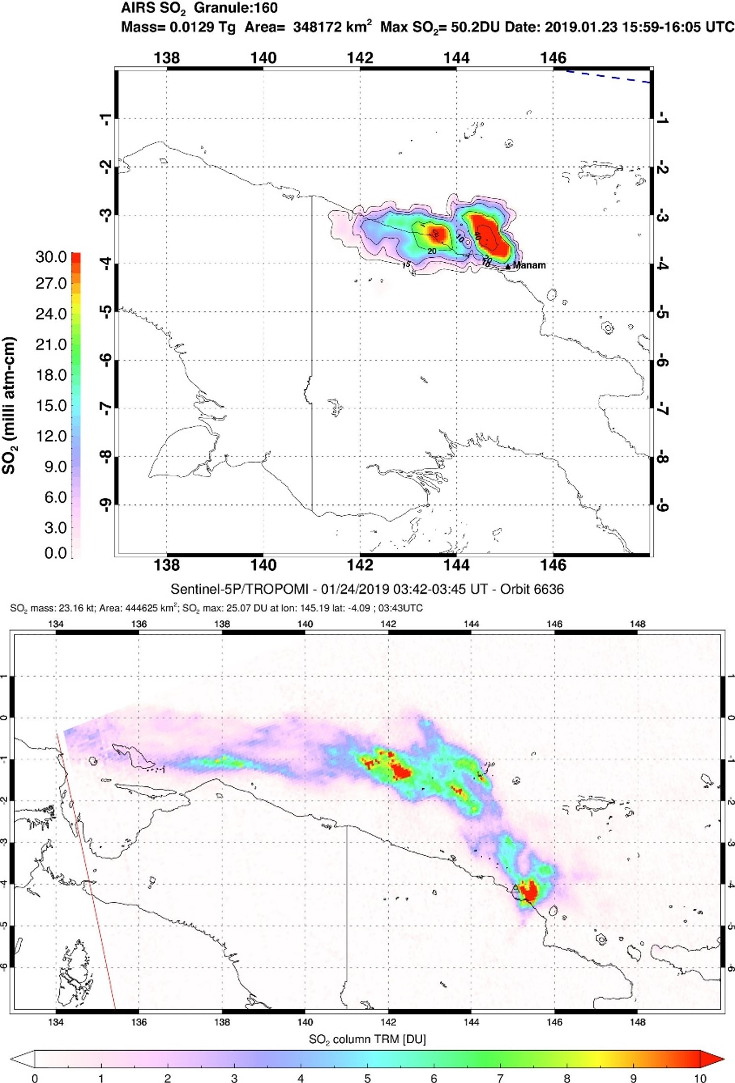 |
Figure 60. SO2 plumes originating from Manam detected by NASA Aqua/AIRS (top) on 23 January 2019 and by Sentinel-5P/TROPOMI on 24 January (bottom). Images courtesy of Simon Carn, Michigan Technological University. |
Ash plumes rose up to 3 km between 1 and 5 March, and dispersed to the SE, ESE, and E. During 5-6 March the plumes moved E, and the events were accompanied by elevated seismicity and significant thermal anomalies detected in satellite data. During 19-22 March explosions produced ash plumes up to 4.6 km altitude, which dispersed to the E and SE. Simon Carn of the Michigan Technological University noted a plume in Aqua/AIRS data at around 15 km altitude at 0400 UTC on 23 January with approximately 13 kt measured, similar to other recent eruptions. Additional ash plumes were detected on 29 March, reaching 2.4-3 km and drifting to the E, NE, and N. Multiple SO2 plumes were detected throughout April (figure 61).
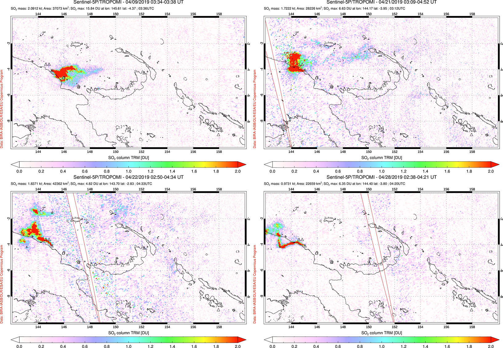 |
Figure 61. Examples of elevated SO2 (sulfur dioxide) emissions from Manam during April 2019, on 9 April (top left), 21 April (top right), 22 April (bottom left), 28 April (bottom right). Courtesy of the NASA Space Goddard Flight Center. |
During 19-28 May the Deep Carbon Observatory ABOVE (Aerial-based Observations of Volcanic Emissions) scientific team observed activity at Manam and collected gas data using drone technology. They recorded degassing from the South Crater and Main Crater (figure 63 and 64), which was also detected in Sentinel-5P/TROPOMI data (figure 65). Later in the day the plumes rose vertically up to 3-4 km above sea level and appeared stronger due to condensation. Incandescence was observed each night at the South Crater (figure 66). The Darwin VAAC reported an ash plume on 10 May, reaching 5.5 km altitude and drifting to the NE. Smaller plumes up to 2.4 km were noted on the 11th.
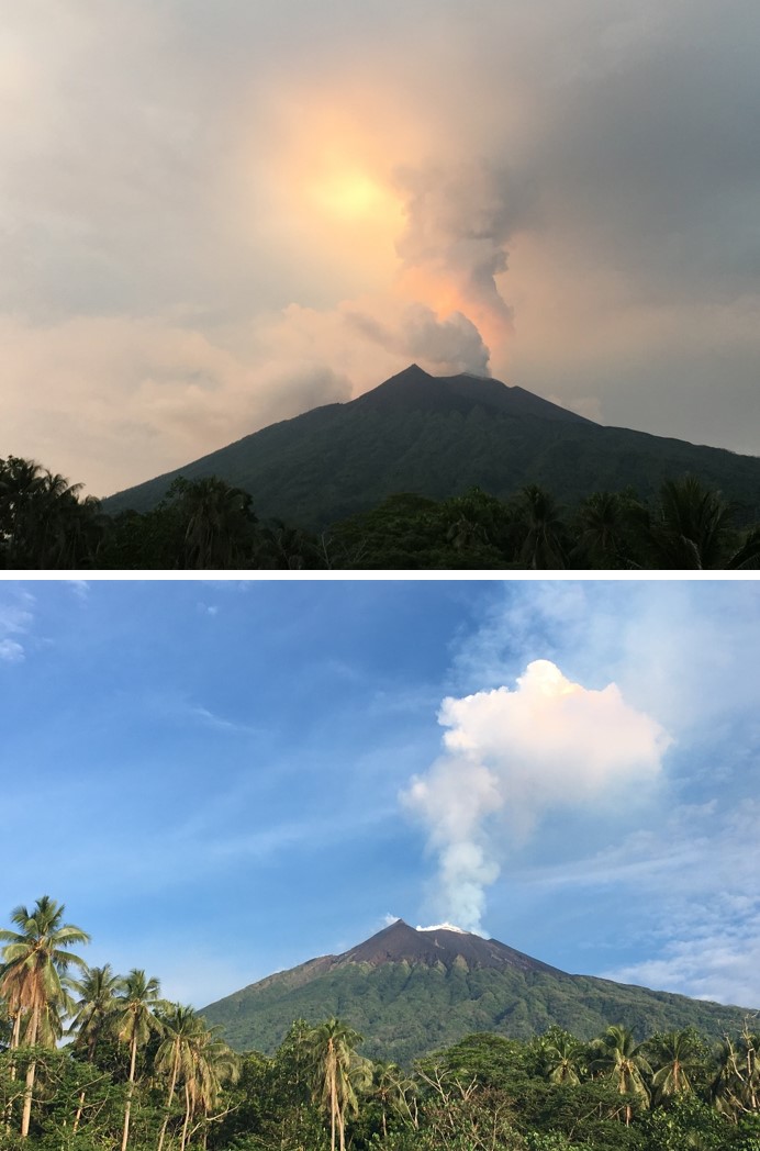 |
Figure 62. Degassing plumes from the South Crater of Manam, seen from Baliau village on the northern coast on 24 May 2019. Courtesy of Emma Liu, University College London. |
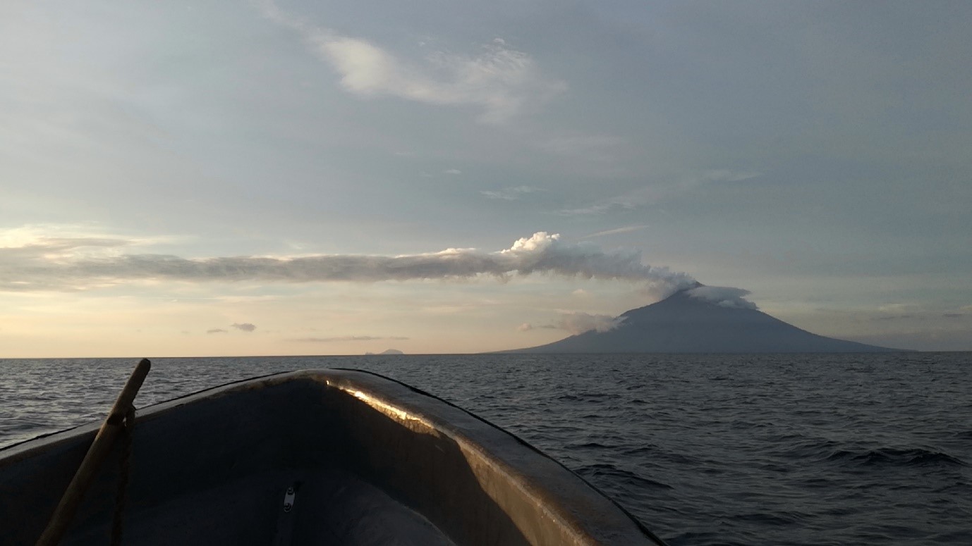 |
Figure 63. A strong gas-and-steam plume from Manam was observed moving tens of kilometers downwind on 19 May 2019, viewed here form the SSW at dusk. Photo courtesy of Julian Rüdiger, Johannes Gutenberg University Mainz. |
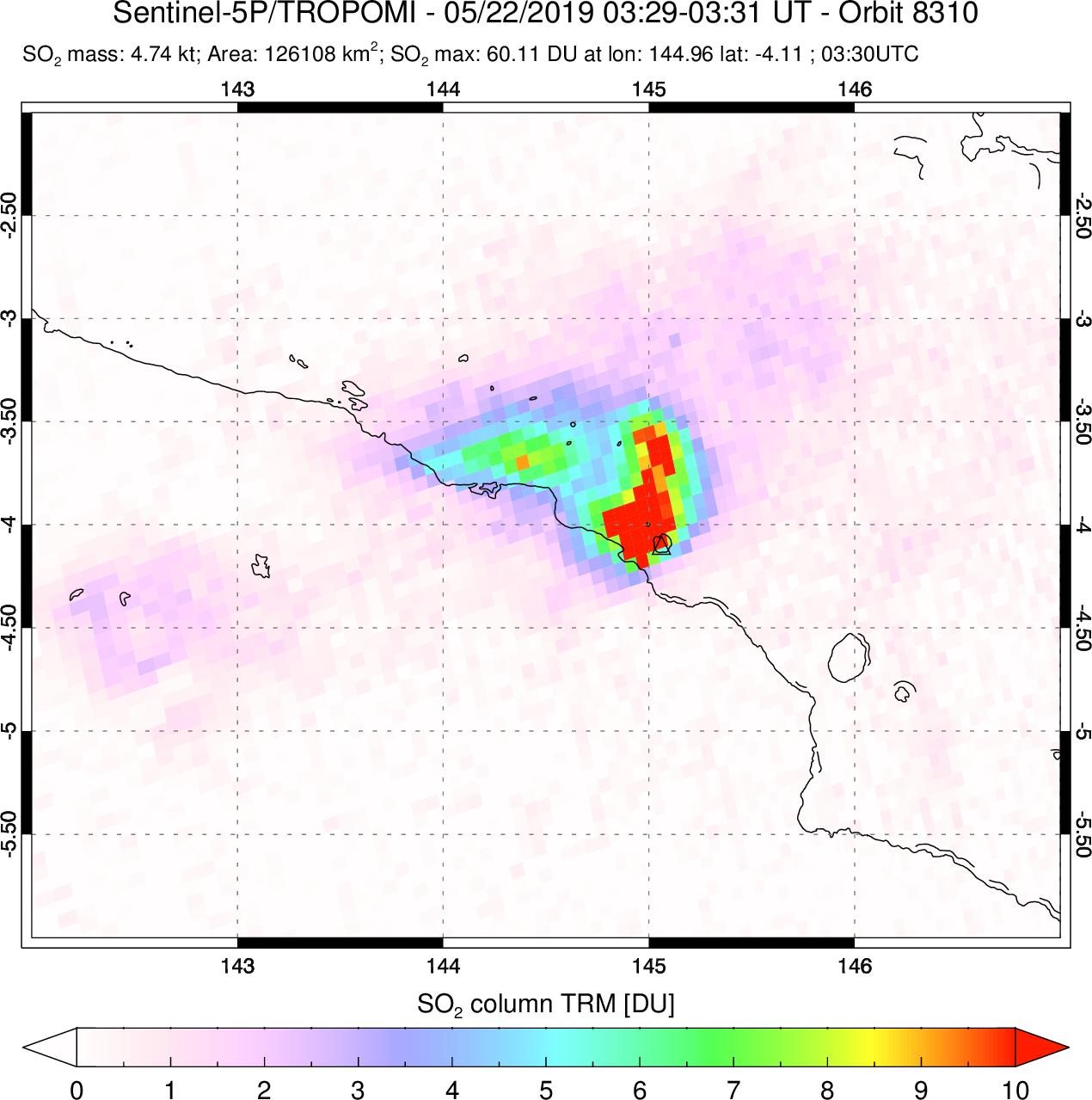 |
Figure 64. Sentinel-5P/TROPOMI SO2 data acquired on 22 May 2019 during the field observations of the Deep Carbon Observatory ABOVE team. Image courtesy of Simon Carn, Michigan Technological University. |
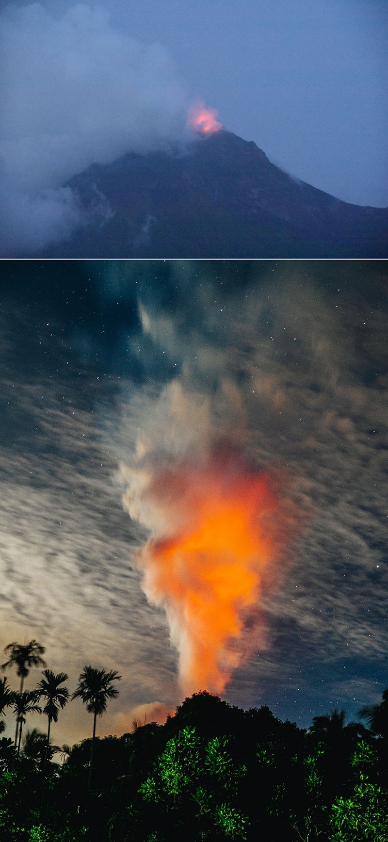 |
Figure 65. Incandescence at the South Crater of Manam was visible during 19-21 May 2019 from the Baliau village on the northern coast of the island. Photos courtesy of Tobias Fischer, University of New Mexico (top) and Matthew Wordell (bottom). |
Activity during June 2019. Ash plumes rose to 4.3 km and drifted SW on 7-8 June, and up to 3-3.7 km and towards the E and NE on 18 June. Sentinel-2 thermal satellite data show hot material around the Main Crater on 24 June (figure 66). On 27 June RVO reported that RSAM (Real-time Seismic Amplitude Measurement, a measure of seismic activity through time) increased from 540 to over 1,400 in 30 minutes. "Thundering noise" was noted by locals at around 0100 on the 28th. An ash plume drifting SW was visible in satellite images acquired after 0620, coinciding with reported sightings by nearby residents (figure 67). The Darwin VAAC noted that by 0910 the ash plume had reached 15.2 km altitude and was drifting SW. When seen in satellite imagery at 1700 that day the large ash plume had detached and remained visible extending SW. There were 267 lightning strokes detected within 75 km during the event (figure 68) and pyroclastic flows were generated down the NE and W flanks. At 0745 on 29 June an ash plume reached up to 4.8 km.
Villages including Dugulava, Yassa, Budua, Madauri, Waia, Dangale, and Bokure were impacted by ashfall and approximately 3,775 people had evacuated to care centers. Homes and crops were reportedly damaged due to falling ash and scoria. Flights through Madang airport were also disrupted due to the ash until they resumed on the 30th. The Office of the Resident Coordinator in Papua New Guinea reported that as many as 455 homes and gardens were destroyed. Humanitarian resources were strained due to another significant eruption at nearby Ulawun that began on 26 June.
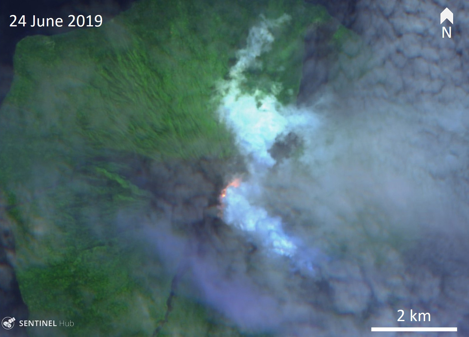 |
Figure 66. Sentinel-2 thermal satellite data show hot material around the Main Crater and a plume dispersing SE through light cloud cover on 24 June 2019. Courtesy of Sentinel Hub Playground. |
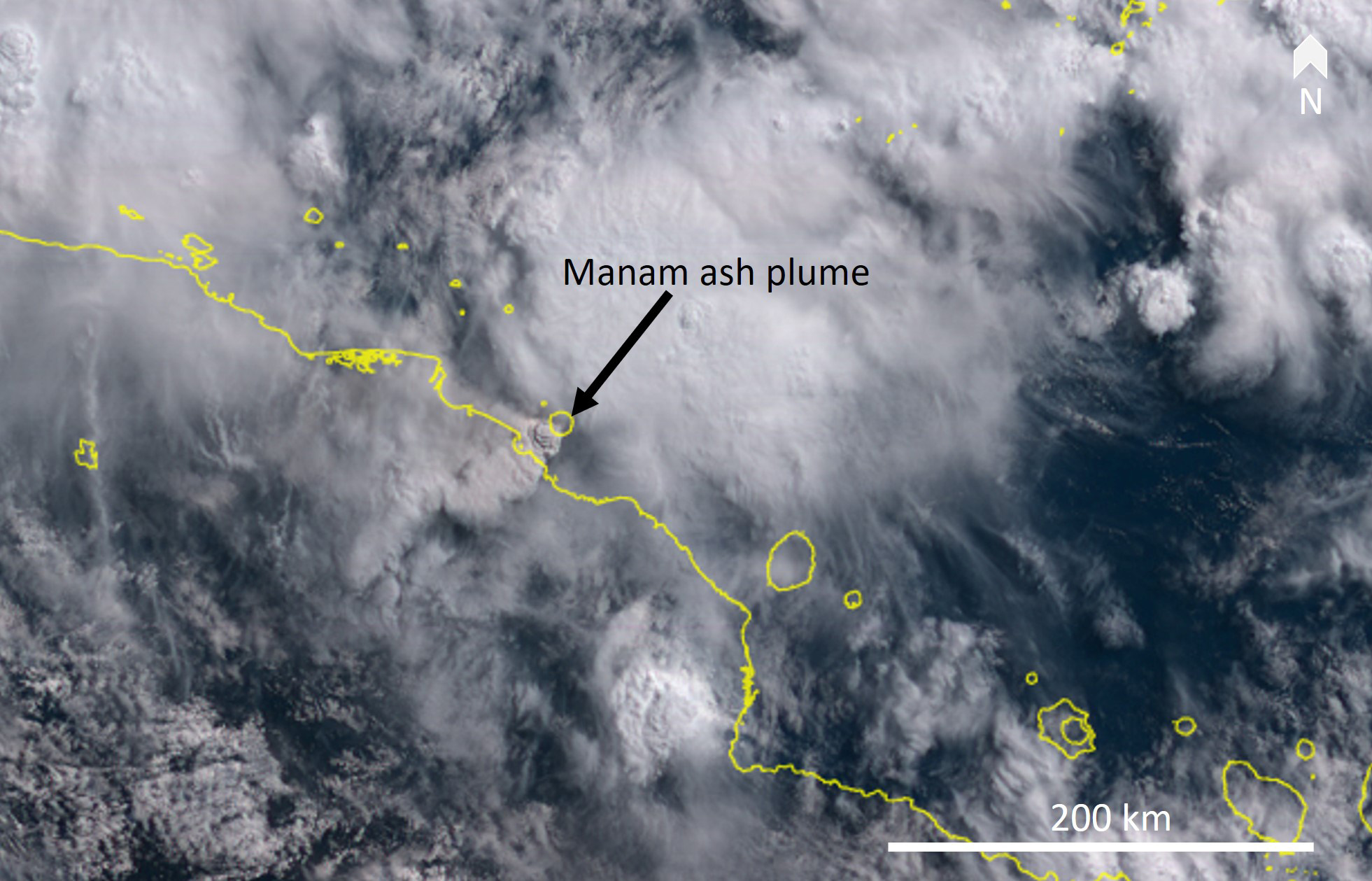 |
Figure 67. Himawari-8 satellite image showing the ash plume rising above Manam and drifting SW at 0840 on 28 June. Satellite image courtesy of NCIT ScienceCloud. |
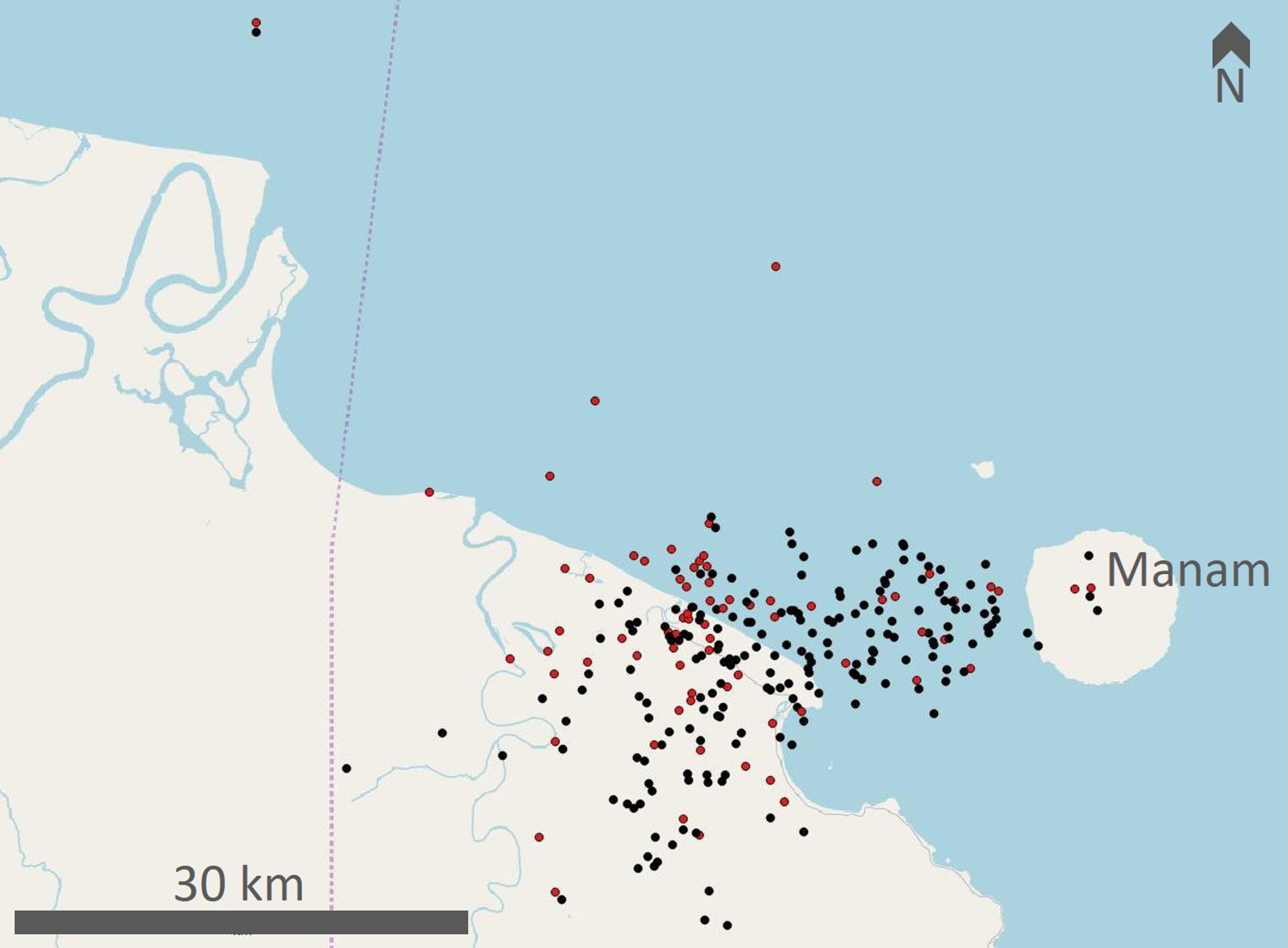 |
Figure 68. There were 267 lightning strokes detected within 75 km of Manam between 0729 on 27 June and 0100 on 29 June 2019. Sixty of these occurred within the final two hours of this observation period, reflecting increased activity. Red dots are cloud to ground lightning strokes and black dots are in-cloud strokes. Courtesy of Chris Vagasky, Vaisala Inc. |
Activity during July-September 2019. Activity was reduced through July and September. The Darwin VAAC reported an ash plume to approximately 6 km altitude on 6 July that drifted W and NW, another plume that day to 3.7 km that drifted N, and a plume on the 21st that rose to 4.3 km and drifted SW and W. Diffuse plumes rose to 2.4-2.7 km and drifted towards the W on 29 September. Thermal anomalies in the South Crater persisted through September.
Fresh deposits from recent events are visible in satellite deposits, notably in the NE after the January activity (figure 69). Satellite TIR data reflected elevated activity with increased energy detected in March and June-July in MODVOLC and MIROVA data (figure 70).
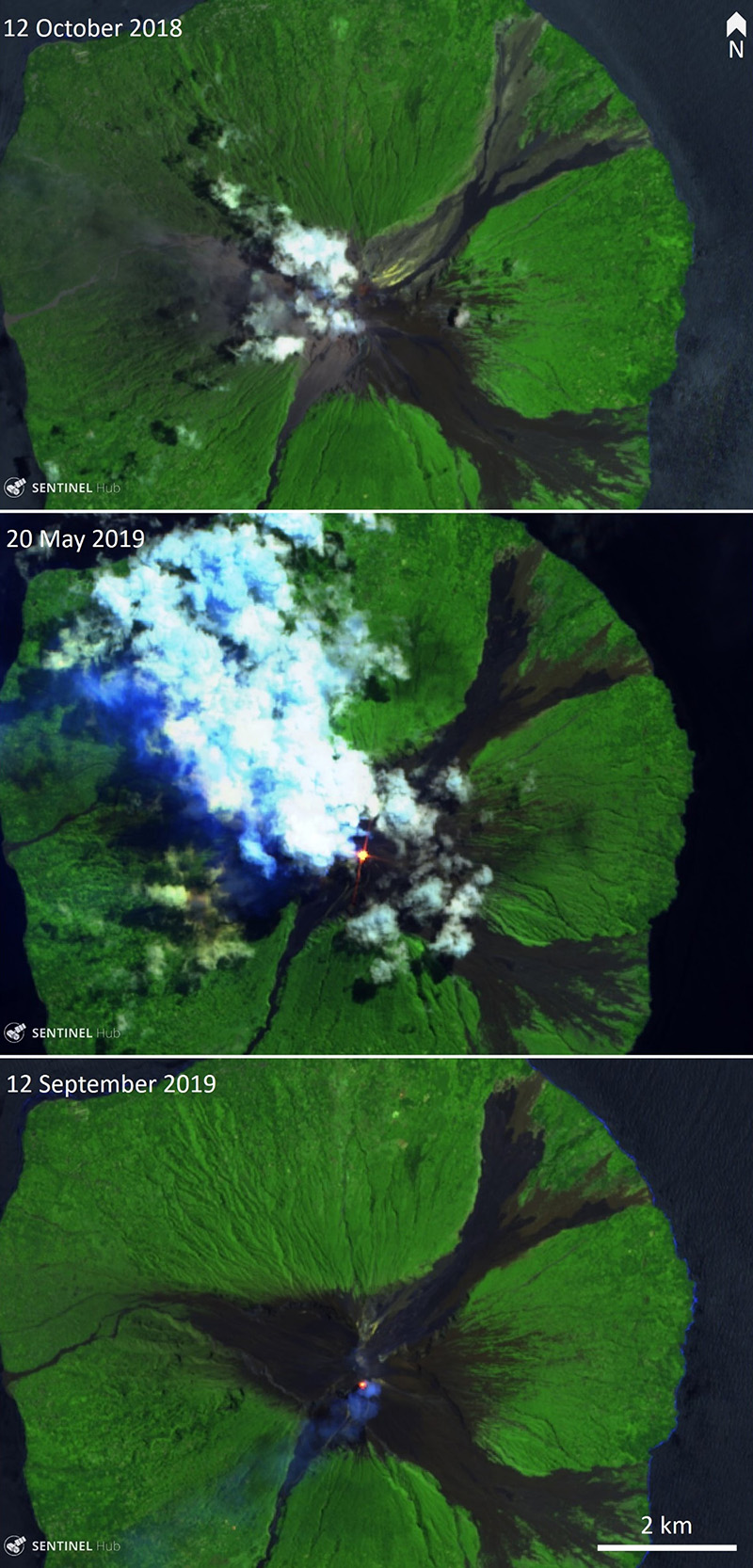 |
Figure 69. Sentinel-2 thermal infrared images acquired on 12 October 2018, 20 May 2019, and 12 September 2019 show the eruption deposits that accumulated during this time. A thermal anomaly is visible in the South Crater in the May and September images. Courtesy of Sentinel Hub Playground. |
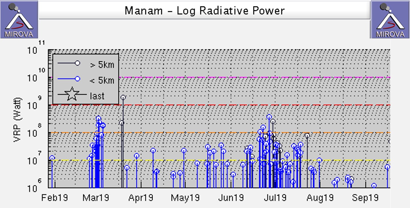 |
Figure 70. MIROVA log radiative power plot of MODIS thermal infrared at Manam during February through September 2019. Increases in activity were detected in March and June-July. Courtesy of MIROVA. |
Information Contacts: Rabaul Volcano Observatory (RVO), Geohazards Management Division, Department of Mineral Policy and Geohazards Management (DMPGM), PO Box 3386, Kokopo, East New Britain Province, Papua New Guinea; Global Sulfur Dioxide Monitoring Page, Atmospheric Chemistry and Dynamics Laboratory, NASA Goddard Space Flight Center (NASA/GSFC), 8800 Greenbelt Road, Goddard, Maryland, USA (URL: https://SO2.gsfc.nasa.gov/); Sentinel Hub Playground (URL: https://www.sentinel-hub.com/explore/sentinel-playground); MIROVA (Middle InfraRed Observation of Volcanic Activity), a collaborative project between the Universities of Turin and Florence (Italy) supported by the Centre for Volcanic Risk of the Italian Civil Protection Department (URL: http://www.mirovaweb.it/); Hawai'i Institute of Geophysics and Planetology (HIGP) - MODVOLC Thermal Alerts System, School of Ocean and Earth Science and Technology (SOEST), Univ. of Hawai'i, 2525 Correa Road, Honolulu, HI 96822, USA (URL: http://modis.higp.hawaii.edu/); Office of the Resident Coordinator, United Nations, Port Moresby, National Capital District, Papua New Guinea (URL: https://papuanewguinea.un.org/en/about/about-the-resident-coordinator-office, https://reliefweb.int/report/papua-new-guinea/papua-new-guinea-volcanic-activity-office-resident-coordinator-flash-2); Himawari-8 Real-time Web, developed by the NICT Science Cloud project in NICT (National Institute of Information and Communications Technology), Japan, in collaboration with JMA (Japan Meteorological Agency) and CEReS (Center of Environmental Remote Sensing, Chiba University) (URL: https://himawari8.nict.go.jp/); Simon Carn, Geological and Mining Engineering and Sciences, Michigan Technological University, 1400 Townsend Drive, Houghton, MI 49931, USA (URL: http://www.volcarno.com/, Twitter: @simoncarn); Chris Vagasky, Vaisala Inc., Louisville, Colorado, USA (URL: https://www.vaisala.com/en?type=1, Twitter: @COweatherman, URL: https://twitter.com/COweatherman); Emma Liu, University College London Earth Sciences, London WC1E 6BS (URL: https://www.ucl.ac.uk/earth-sciences/people/academic/dr-emma-liu); Matthew Wordell, Boise, ID, USA (URL: https://www.matthhew.com/biocontact); Julian Rüdiger, Johannes Gutenberg University Mainz, Saarstr. 21, 55122 Mainz, Germany (URL: https://www.uni-mainz.de/); Planet Labs, Inc. (URL: https://www.planet.com/);.
Minor explosive activity, continued thermal activity, and SO2 emissions, October 2019-March 2020.
Manam is a basaltic-andesitic stratovolcano that lies 13 km off the northern coast of mainland Papua New Guinea; it has a 400-year history of recorded evidence for recurring low-level ash plumes, occasional Strombolian activity, lava flows, pyroclastic avalanches, and large ash plumes from Main and South, the two active summit craters. The current eruption, ongoing since June 2014, produced multiple large explosive eruptions during January-September 2019, including two 15-km-high ash plumes in January, repeated SO2 plumes each month, and another 15.2 km-high ash plume in June that resulted in ashfall and evacuations of several thousand people (BGVN 44:10).
This report covers continued activity during October 2019 through March 2020. Information about Manam is primarily provided by Papua New Guinea's Rabaul Volcano Observatory (RVO), part of the Department of Mineral Policy and Geohazards Management (DMPGM). This information is supplemented with aviation alerts from the Darwin Volcanic Ash Advisory Center (VAAC). MODIS thermal anomaly satellite data is recorded by the University of Hawai'i's MODVOLC thermal alert recording system, and the Italian MIROVA project; sulfur dioxide monitoring is done by instruments on satellites managed by NASA's Goddard Space Flight Center. Satellite imagery provided by the Sentinel Hub Playground is also a valuable resource for information about this remote location.
A few modest explosions with ash emissions were reported in early October and early November 2019, and then not again until late March 2020. Although there was little explosive activity during the period, thermal anomalies were recorded intermittently, with low to moderate activity almost every month, as seen in the MODIS data from MIROVA (figure 71) and also in satellite imagery. Sulfur dioxide emissions persisted throughout the period producing emissions greater than 2.0 Dobson Units that were recorded in satellite data 3-13 days each month.
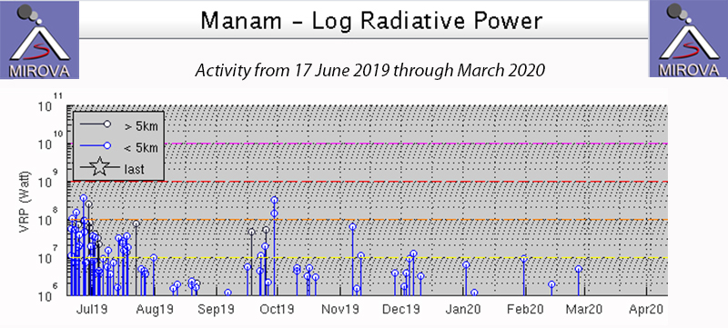 |
Figure 71. MIROVA thermal anomaly data for Manam from 17 June 2019 through March 2020 indicate continued low and moderate level thermal activity each month from August 2019 through February 2020, after a period of increased activity in June and early July 2019. Courtesy of MIROVA. |
The Darwin VAAC reported an ash plume in visible satellite imagery moving NW at 3.1 km altitude on 2 October 2019. Weak ash emissions were observed drifting N for the next two days along with an IR anomaly at the summit. RVO reported incandescence at night during the first week of October. Visitors to the summit on 18 October 2019 recorded steam and fumarolic activity at both of the summit craters (figure 72) and recent avalanche debris on the steep slopes (figure 73).
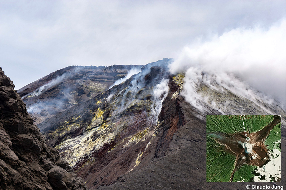 |
Figure 72. Steam and fumarolic activity rose from Main crater at Manam on 18 October 2019 in this view to the south from a ridge north of the crater. Google Earth inset of summit shows location of photograph. Courtesy of Vulkanologische Gesellschaft and Claudio Jung, used with permission. |
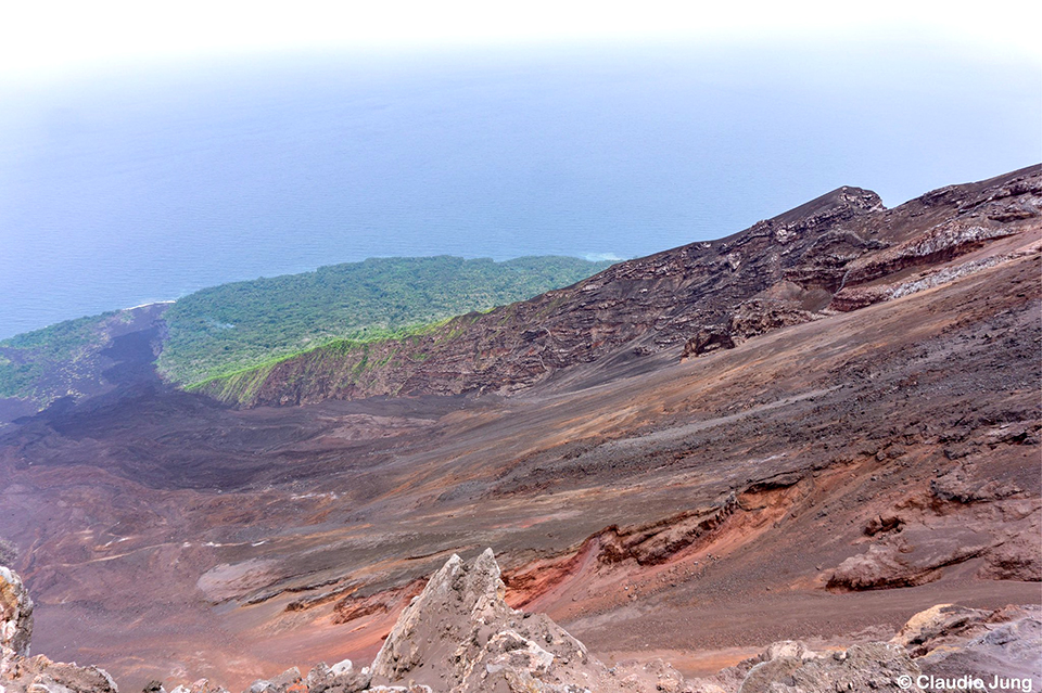 |
Figure 73. Volcanic debris covered an avalanche chute on the NE flank of Manam when visited by hikers on 18 October 2019. Courtesy of Vulkanologische Gesellschaft and Claudio Jung, used with permission. |
On 2 November, a single large explosion at 1330 local time produced a thick, dark ash plume that rose about 1,000 m above the summit and drifted NW. A shockwave from the explosion was felt at the Bogia Government station located 40 km SE on the mainland about 1 minute later. RVO reported an increase in seismicity on 6 November about 90 minutes before the start of a new eruption from the Main Crater which occurred between 1600 and 1630; it produced light to dark gray ash clouds that rose about 1,000 m above the summit and drifted NW. Incandescent ejecta was visible at the start of the explosion and continued with intermittent strong pulses after dark, reaching peak intensity around 1900. Activity ended by 2200 that evening. The Darwin VAAC reported a discrete emission observed in satellite imagery on 8 November that rose to 4.6 km altitude and drifted WNW, although ground observers confirmed that no eruption took place; emissions were only steam and gas. There were no further reports of explosive activity until the Darwin VAAC reported an ash emission in visible satellite imagery on 20 March 2020 that rose to 3.1 km altitude and drifted E for a few hours before dissipating.
Although explosive activity was minimal during the period, SO2 emissions, and evidence for continued thermal activity were recorded by satellite instruments each month. The TROPOMI instrument on the Sentinel-5P satellite captured evidence each month of SO2 emissions exceeding two Dobson Units (figure 74). The most SO2 activity occurred during October 2019, with 13 days of signatures over 2.0 DU. There were six days of elevated SO2 each month in November and December, and five days in January 2020. During February and March, activity was less, with smaller SO2 plumes recording more than 2.0 DU on three days each month. Sentinel-2 satellite imagery recorded thermal anomalies at least once from one or both of the summit craters each month between October 2019 and March 2020 (figure 75).
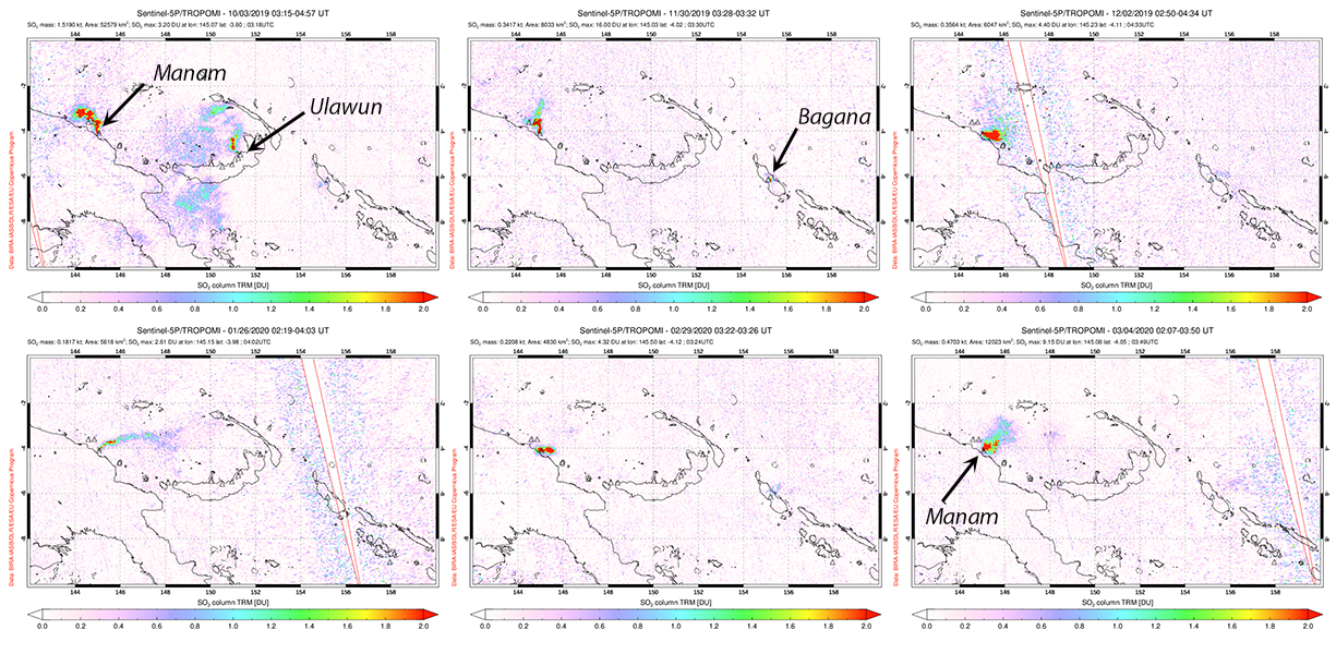 |
Figure 74. SO2 emissions at Manam exceeded 2 Dobson Units multiple days each month between October 2019 and March 2020. On 3 October 2019 (top left) emissions were also measured from Ulawun located 700 km E on New Britain island. On 30 November 2019 (top middle), in addition to a plume drifting N from Manam, a small SO2 plume was detected at Bagana on Bougainville Island, 1150 km E. The plume from Manam on 2 December 2019 drifted ESE (top right). On 26 January 2020 the plume drifted over 300 km E (bottom left). The plumes measured on 29 February and 4 March 2020 (bottom middle and right) only drifted a few tens of kilometers before dissipating. Courtesy of NASA Global Sulfur Dioxide Monitoring Page. |
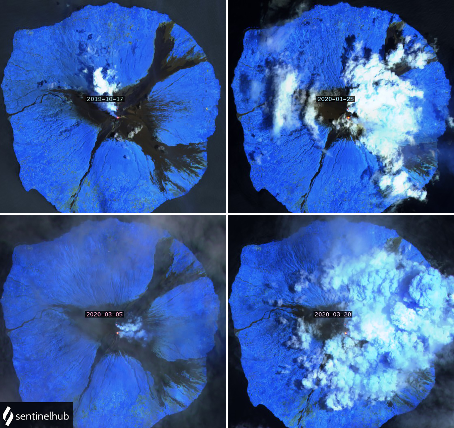 |
Figure 75. Sentinel-2 satellite imagery with Atmospheric penetration rendering (bands 12, 11, and 8a) showed thermal anomalies at one or both of Manam’s summit craters each month during October 2019-March 2020. On 17 October 2019 (top left) a bright anomaly and weak gas plume drifted NW from South crater, while a dense steam plume and weak anomaly were present at Main crater. On 25 January 2020 (top right) the gas and steam from the two craters were drifting E; the weaker Main crater thermal anomaly is just visible at the edge of the clouds. A clear image on 5 March 2020 (bottom left) shows weak plumes and distinct thermal anomalies from both craters; on 20 March (bottom right) the anomalies are still visible through dense cloud cover that may include steam from the crater vents as well. Courtesy of Sentinel Hub Playground. |
Information Contacts: Rabaul Volcano Observatory (RVO), Geohazards Management Division, Department of Mineral Policy and Geohazards Management (DMPGM), PO Box 3386, Kokopo, East New Britain Province, Papua New Guinea; Darwin Volcanic Ash Advisory Centre (VAAC), Bureau of Meteorology, Northern Territory Regional Office, PO Box 40050, Casuarina, NT 0811, Australia (URL: http://www.bom.gov.au/info/vaac/); MIROVA (Middle InfraRed Observation of Volcanic Activity), a collaborative project between the Universities of Turin and Florence (Italy) supported by the Centre for Volcanic Risk of the Italian Civil Protection Department (URL: http://www.mirovaweb.it/); Global Sulfur Dioxide Monitoring Page, Atmospheric Chemistry and Dynamics Laboratory, NASA Goddard Space Flight Center (NASA/GSFC), 8800 Greenbelt Road, Goddard, Maryland, USA (URL: https://so2.gsfc.nasa.gov/); Sentinel Hub Playground (URL: https://www.sentinel-hub.com/explore/sentinel-playground); Vulkanologische Gesellschaft (URL: https://twitter.com/vulkanologen/status/1194228532219727874, https://twitter.com/vulkanologen/status/1193788836679225344); Claudio Jung, (URL: https://www.facebook.com/claudio.jung.1/posts/10220075272173895, https://www.instagram.com/jung.claudio/).
Intermittent ash plumes, thermal anomalies, and SO2 emissions in April-September 2020
Manam, located 13 km off the N coast of Papua New Guinea, is a basaltic-andesitic stratovolcano with historical eruptions dating back 400 years. Volcanism has been characterized by low-level ash plumes, occasional Strombolian activity, lava flows, pyroclastic avalanches, and large ash plumes from Main and South, the two active summit craters. The current eruption period has been ongoing since 2014, typically with minor explosive activity, thermal activity, and SO2 emissions (BGVN 45:05). This reporting period updates information from April through September 2020, consisting of intermittent ash plumes from late July to mid-September, persistent thermal anomalies, and SO2 emissions. Information comes from Papua New Guinea's Rabaul Volcano Observatory (RVO), part of the Department of Mineral Policy and Geohazards Management (DMPGM), the Darwin Volcanic Ash Advisory Center (VAAC), and various satellite data.
Explosive activity was relatively low during April through late July; SO2 emissions and low power, but persistent, thermal anomalies were detected by satellite instruments each month. The TROPOMI instrument on the Sentinel-5P satellite recorded SO2 emissions, many of which exceeded two Dobson Units, that drifted generally W (figure 76). Distinct SO2 emissions were detected for 10 days in April, 4 days in May, 10 days in June, 4 days in July, 11 days in August, and 8 days in September.
Thermal anomalies recorded by the MIROVA (Middle InfraRed Observation of Volcanic Activity) system were sparse from early January through June 2020, totaling 11 low-power anomalies within 5 km of the summit (figure 77). From late July through September a pulse in thermal activity produced slightly stronger and more frequent anomalies. Some of this activity could be observed in Sentinel-2 thermal satellite imagery (figure 78). Occasionally, these thermal anomalies were accompanied by gas-and-steam emissions or ash plumes, as shown on 28 July. On 17 August a particularly strong hotspot was detected in the S summit crater. According to the MODVOLC thermal alert data, a total of 10 thermal alerts were detected in the summit crater over four days: 29 July (5), 16 August (1), and 3 (1) and 8 (3) September.
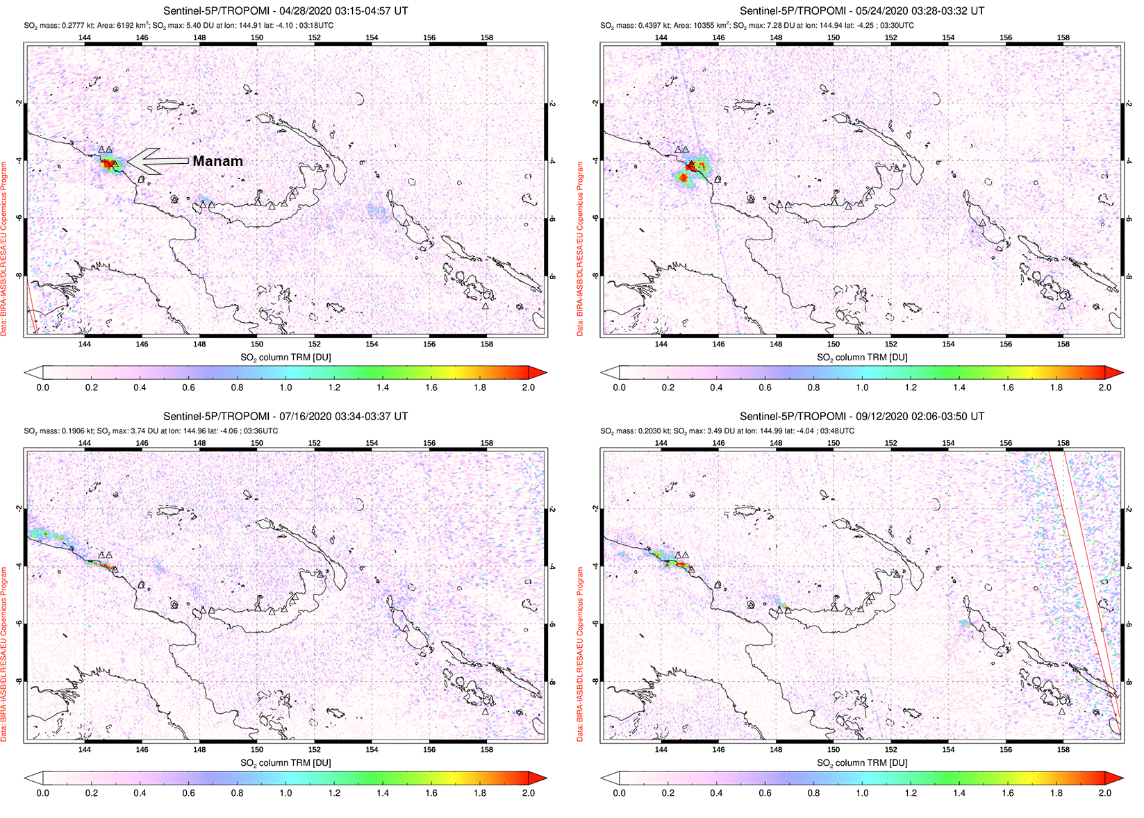 |
Figure 76. Distinct sulfur dioxide plumes rising from Manam and drifting generally W were detected using data from the TROPOMI instrument on the Sentinel-5P satellite on 28 April (top left), 24 May (top right), 16 July (bottom left), and 12 September (bottom right) 2020. Courtesy of the NASA Global Sulfur Dioxide Monitoring Page. |
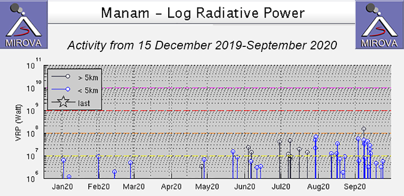 |
Figure 77. Intermittent thermal activity at Manam increased in power and frequency beginning around late July and continuing through September 2020, as shown on the MIROVA Log Radiative Power graph. Courtesy of MIROVA. |
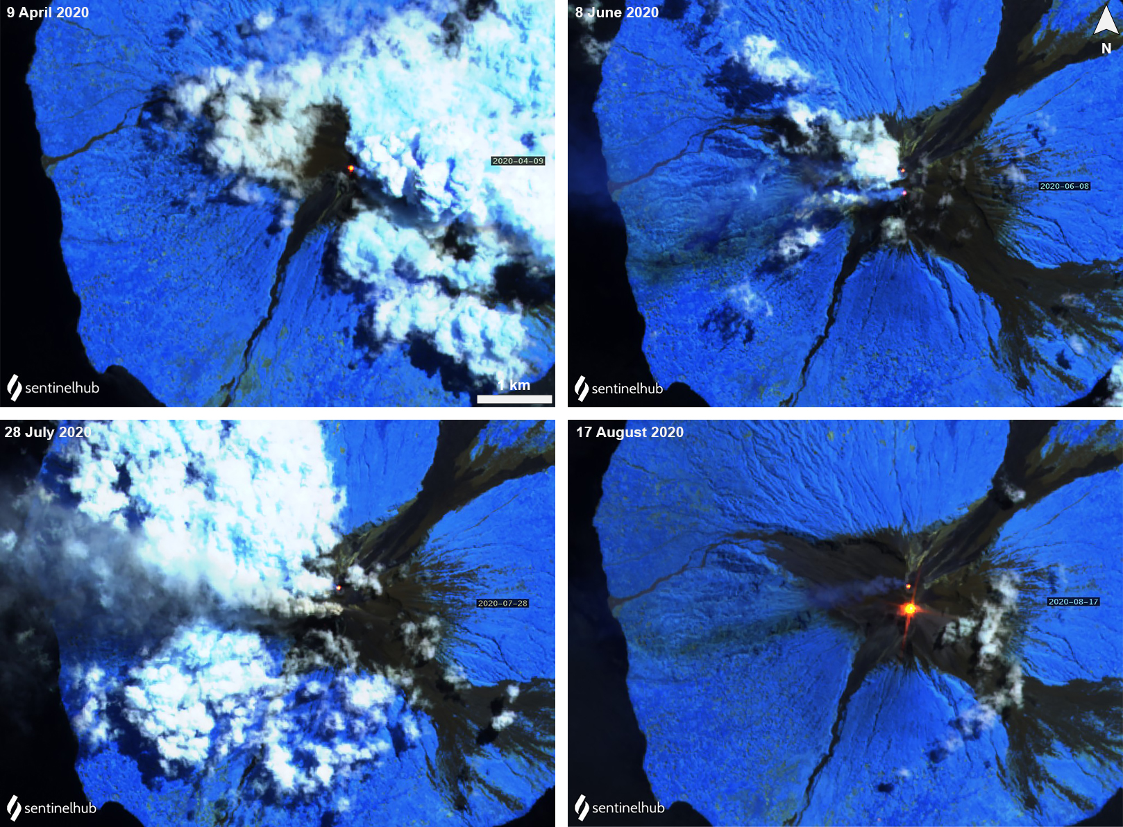 |
Figure 78. Sentinel-2 thermal satellite images showing a persistent thermal anomaly (yellow-orange) at Manam’s summit craters (Main and South) each month during April through August; sometimes they were seen in both summit craters, as shown on 8 June (top right), 28 July (bottom left), and 17 August (bottom right). A particularly strong anomaly was visible on 17 August (bottom right). Occasional gas-and-steam emissions accompanied the thermal activity. Sentinel-2 satellite images with “Atmospheric penetration” (bands 12, 11, 8A) rendering; courtesy of Sentinel Hub Playground. |
Activity during mid-July slightly increased compared to the previous months. On 16 July seismicity increased, fluctuating between low and moderate RSAM values through the rest of the month. In Sentinel-2 satellite imagery a gray ash plume was visible rising from the S summit crater on 28 July (figure 78). RSAM values gradually increased from a low average of 200 to an average of 1200 on 30 July, accompanied by thermal hotspots around the summit crater; a ground observer reported incandescent material was ejected from the summit. On 31 July into 1 August ash plumes rose to 4.3 km altitude, accompanied by an incandescent lava flow visible at the summit, according to a Darwin VAAC advisory.
Intermittent ash plumes continued to be reported by the Darwin VAAC on 1, 6-7, 16, 20, and 31 August. They rose from 2.1 to 4.6 km altitude, the latter of which occurred on 31 August and drifted W. Typically, these ash plumes extended SW, W, NW, and WSW. On 11 September another ash plume was observed rising 2.4 km altitude and drifting W.
Information Contacts: Rabaul Volcano Observatory (RVO), Geohazards Management Division, Department of Mineral Policy and Geohazards Management (DMPGM), PO Box 3386, Kokopo, East New Britain Province, Papua New Guinea; Darwin Volcanic Ash Advisory Centre (VAAC), Bureau of Meteorology, Northern Territory Regional Office, PO Box 40050, Casuarina, NT 0811, Australia (URL: http://www.bom.gov.au/info/vaac/); MIROVA (Middle InfraRed Observation of Volcanic Activity), a collaborative project between the Universities of Turin and Florence (Italy) supported by the Centre for Volcanic Risk of the Italian Civil Protection Department (URL: http://www.mirovaweb.it/); Hawai'i Institute of Geophysics and Planetology (HIGP) - MODVOLC Thermal Alerts System, School of Ocean and Earth Science and Technology (SOEST), Univ. of Hawai'i, 2525 Correa Road, Honolulu, HI 96822, USA (URL: http://modis.higp.hawaii.edu/); Global Sulfur Dioxide Monitoring Page, Atmospheric Chemistry and Dynamics Laboratory, NASA Goddard Space Flight Center (NASA/GSFC), 8800 Greenbelt Road, Goddard, Maryland, USA (URL: https://so2.gsfc.nasa.gov/); Sentinel Hub Playground (URL: https://www.sentinel-hub.com/explore/sentinel-playground).
Ash plumes, SO2 plumes, and thermal anomalies continued during October 2020-March 2021
Manam is located 13 km off the N coast of mainland Papua New Guinea and has had eruptions documented since 1616. It contains two active summit craters, Main and South, which have been characterized by occasional Strombolian activity, lava flows, pyroclastic avalanches, and ash plumes. The current eruption period has been ongoing since 2014 with more recent activity consisting of intermittent ash plumes, thermal anomalies, and sulfur dioxide emissions (BGVN 45:10). This report describes similar activity and covers October 2020 through March 2021 using information primarily from the Darwin Volcanic Ash Advisory Center (VAAC) and various satellite data.
Explosive and thermal activity was relatively low during this reporting period. Three ash plumes were reported by the Darwin VAAC based on imagery from the HIMIWARI-8 satellite. On 6 December 2020 an ash plume rose to 2.4 km altitude and drifted SW. The next VAAC notice was for ash detected on 23 January 2021 rising to 4.9 km and drifting SE and N. Then on 21 February an ash plume rose to a maximum altitude of 6 km and drifted W. Intermittent sulfur dioxide plumes were detected using the TROPOMI instrument on the Sentinel-5P satellite, some of which reached at least two Dobson Units (DU) and drifted in multiple directions (figure 79). On 6 December and 23 January, the ash plume that was described in the Darwin VAAC advisory was accompanied by an SO2 plume. SO2 plumes that reached a minimum of two DU were recorded for at least 12 days during October, 13 days during November, 15 days during December, 10 days during January, 3 days during February, and 6 days during March.
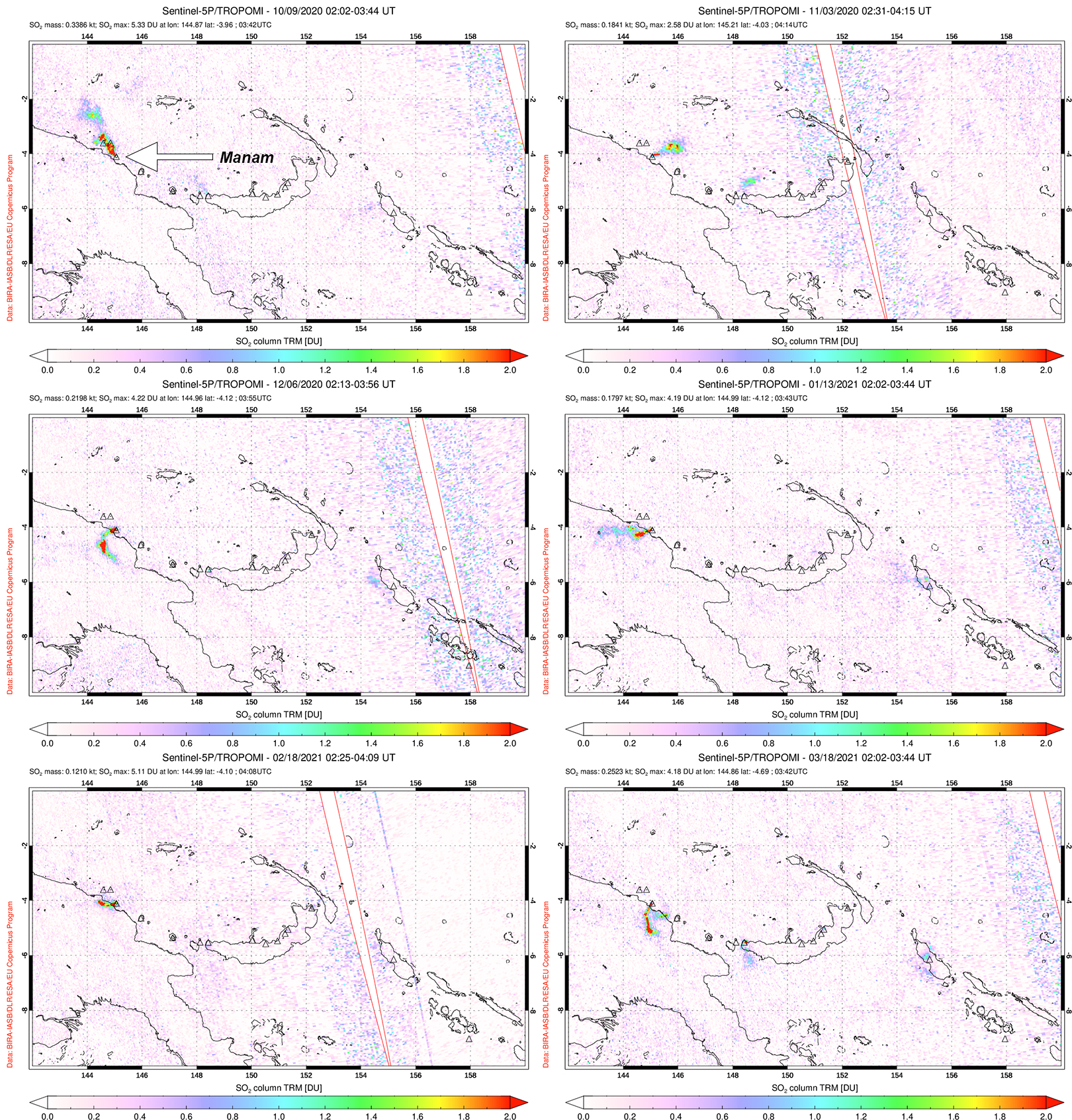 |
Figure 79. Distinct sulfur dioxide plumes rising from Manam and drifting in different directions were detected using data from the TROPOMI instrument on the Sentinel-5P satellite on 9 October (top left), 3 November (top right), 6 December (middle left) 2020, 13 January (middle right), 18 February (bottom left), and 18 March (bottom right) 2021. Courtesy of the NASA Global Sulfur Dioxide Monitoring Page. |
Thermal activity during October 2020 through March 2021 was relatively low in power and frequency compared to August and September, as recorded by the MIROVA (Middle InfraRed Observation of Volcanic Activity) system. Two brief pulses of activity were detected during mid-November and late December to mid-January (figure 80). A total of 14 low-power anomalies were recorded: one in early October, three in mid-November, two in December, a maximum number of six in January, one in late February, and one in late March. Some of this activity was captured in Sentinel-2 thermal satellite imagery on clear weather days in both the Main and South summit craters (figure 81).
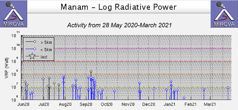 |
Figure 80. Thermal activity at Manam was low to moderate in power during October 2020 through March 2021, with notable brief pulses during mid-November and late December through mid-January, as shown on this MIROVA Log Radiative Power graph. One anomaly was detected in early October, three in mid-November, two in December, six in January, one in late February, and one in late March. Courtesy of MIROVA. |
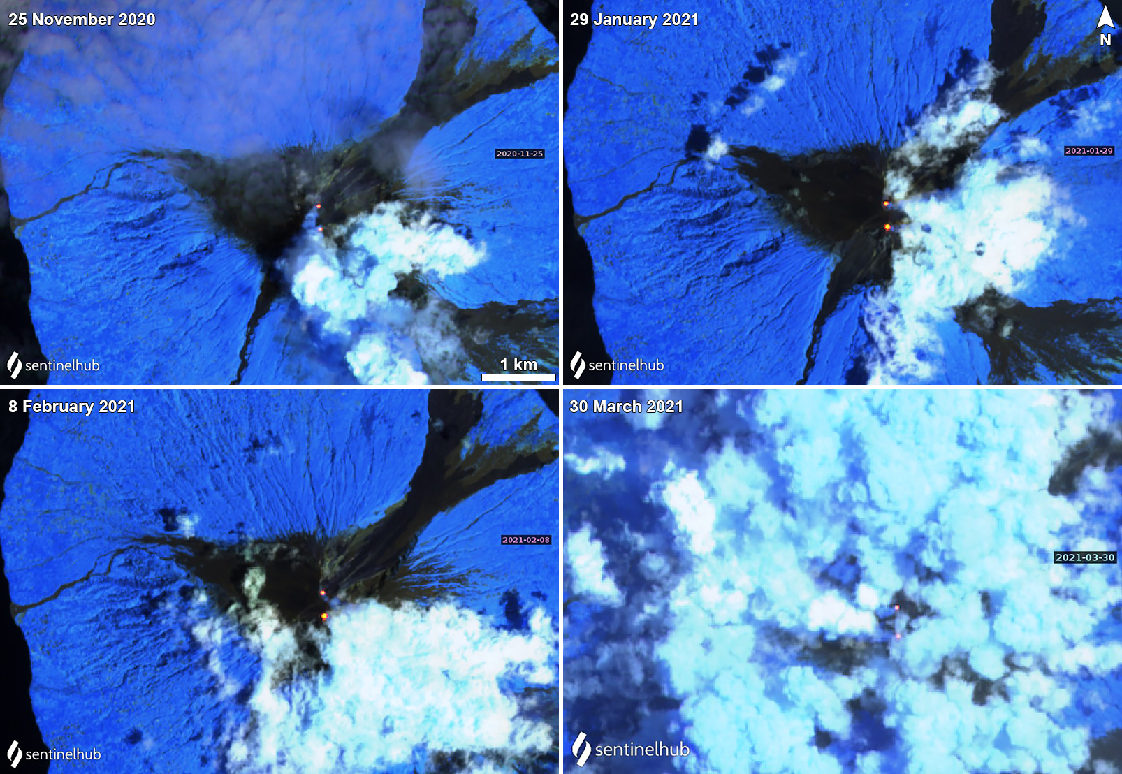 |
Figure 81. Sentinel-2 thermal satellite images show a persistent thermal anomaly (bright yellow-orange) at both of Manam’s summit craters (Main and South) on clear weather days during November 2020 through March 2021. Occasional gas-and-steam emissions accompanied the thermal anomalies as seen on 25 November 2020 (top left), 29 January (top right), 8 February (bottom left), and 20 March (bottom right) 2021. Sentinel-2 satellite images with “Atmospheric penetration” (bands 12, 11, 8A) rendering. Courtesy of Sentinel Hub Playground. |
Information Contacts: Darwin Volcanic Ash Advisory Centre (VAAC), Bureau of Meteorology, Northern Territory Regional Office, PO Box 40050, Casuarina, NT 0811, Australia (URL: http://www.bom.gov.au/info/vaac/); MIROVA (Middle InfraRed Observation of Volcanic Activity), a collaborative project between the Universities of Turin and Florence (Italy) supported by the Centre for Volcanic Risk of the Italian Civil Protection Department (URL: http://www.mirovaweb.it/); NASA Global Sulfur Dioxide Monitoring Page, Atmospheric Chemistry and Dynamics Laboratory, NASA Goddard Space Flight Center (NASA/GSFC), 8800 Greenbelt Road, Goddard, Maryland, USA (URL: https://so2.gsfc.nasa.gov/); Sentinel Hub Playground (URL: https://www.sentinel-hub.com/explore/sentinel-playground).
Explosion on 20 October 2021 included a strong ash plume and debris flow
Eruptions from Manam, located 13 km off the N coast of mainland Papua New Guinea, have been recorded since 1616. It contains two active summit craters, Main and South, which have produced occasional Strombolian activity, lava flows, pyroclastic avalanches, and ash plumes. The current eruption period has been ongoing since 2014, with more recent activity including a strong explosion on 20 October 2021, intermittent ash plumes, sulfur dioxide plumes, and thermal anomalies (BGVN 46:06). This report describes similar activity during April through October 2021 using information primarily from the Rabaul Volcano Observatory (RVO), the Darwin Volcanic Ash Advisory Center (VAAC), and various satellite data.
Activity during May through September was relatively low and primarily consisted of persistent thermal anomalies in the summit craters, infrequent ash plumes (figure 82), and gas-and-steam emissions. Intermittent sulfur dioxide plumes were also detected using the TROPOMI instrument on the Sentinel-5P satellite, some of which reached at least two Dobson Units (DU) and drifted in different directions (figure 83). During 20-21 May an ash plume rose to 2.1 km altitude and drifted NW, based on HIMAWARI-8 satellite data. The next Darwin VAAC notice reported a continuous ash plume rising to 2.1-2.4 km altitude and drifting W, WNW, and NW during 23-24 June. RVO reported small sporadic ash emissions rising from the Southern Crater beginning at the end of September.
 |
Figure 82. Sentinel-2 satellite image showing a dark gray ash plume drifting W from Manam on 23 June 2021. Image using “Natural Color” (bands 4, 3, 2) rendering. Courtesy of Sentinel Hub Playground. |
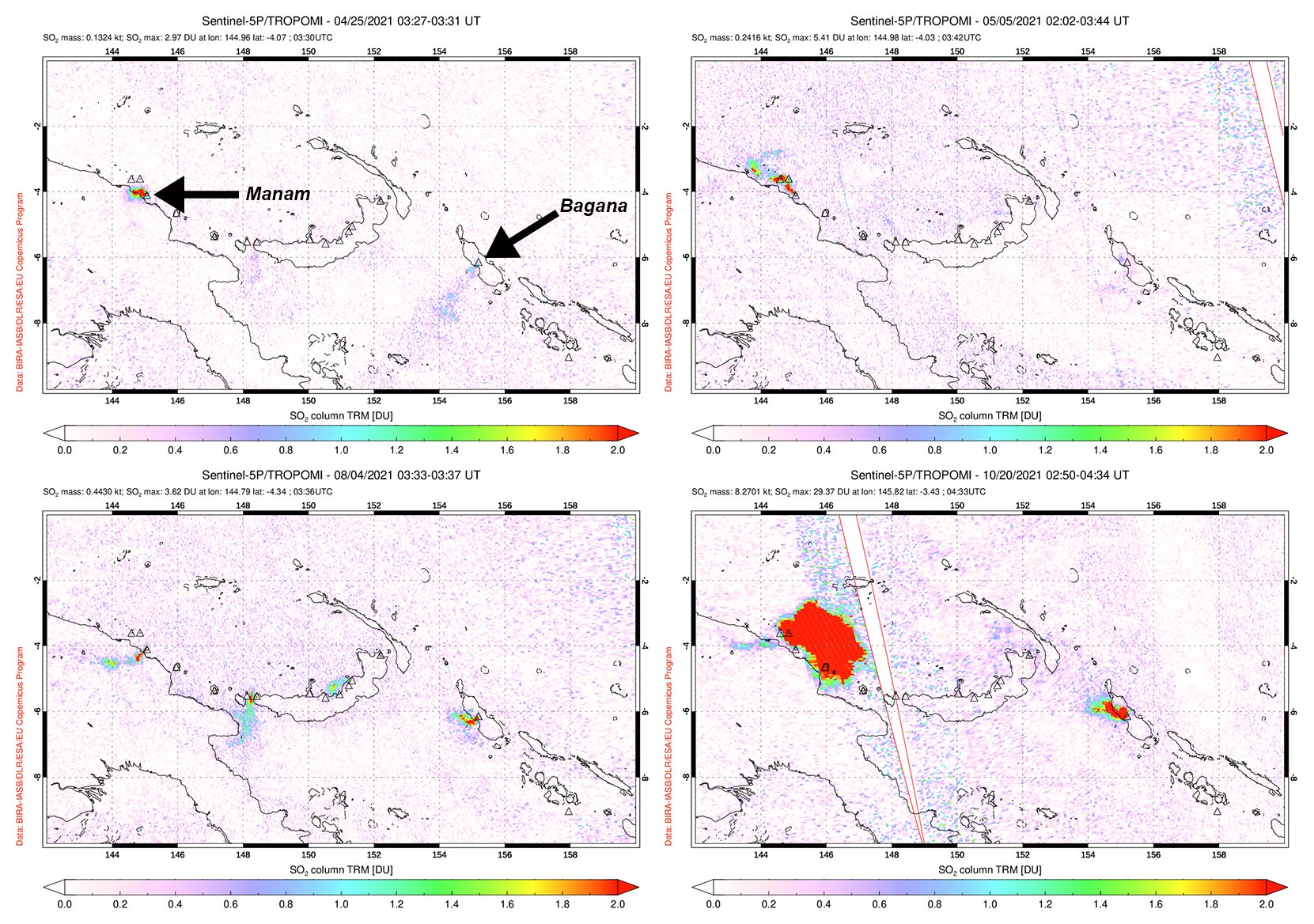 |
Figure 83. Small but distinct sulfur dioxide plumes rising from Manam and drifting in different directions were detected using data from the TROPOMI instrument on the Sentinel-5P satellite on 25 April (top left), 5 May (top right), 4 August (bottom left), and 20 October (bottom right) 2021. During the explosion on 20 October, a strong sulfur dioxide plume was visible with a mass of 8.3 kilotons over the volcano. Courtesy of the NASA Global Sulfur Dioxide Monitoring Page. |
Activity during October increased; starting on 8 October nighttime incandescence began and incandescent material was occasionally ejected from the crater. RVO characterized this activity as moderately Strombolian, as incandescent ejecta was reported rolling down the SW Valley (figure 84), which was also noted in Sentinel-2 infrared satellite imagery on 16 October (figure 85). On 18 October an ash plume rose to 2.4 km altitude and drifted NW based on information from the Darwin VAAC. At 0800 on the morning of 20 October RVO detected a large explosion at the Southern Crater, producing ash plumes that rose at least 1 km above the summit and drifted N and NW. According to the Darwin VAAC, an initial ash plume was reported to 2.1 km altitude and drifted W, which was accompanied by a thermal hotspot seen in infrared satellite imagery. Later that day an ash plume was detected, rising to at least 15.2 km altitude, which expanded radially, and drifted E. Lower-level plumes rose to 4.3-5.5 km altitude extending to the NW. Collapses of both the newly erupted material collapsed, and deposits from the previous weeks, generated a debris flow from the head of the valley down the SW flank. The strong ash plume continued into the next day on 21 October that rose to 10.7-15.2 km altitude while the lower-level plumes rose to 4.6 km altitude and drifted W. After the main ash plume dispersed, ground-based observers reported ongoing smaller ash emissions that rose to 2.4 km altitude on 21 October.
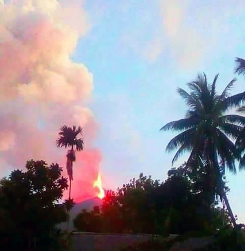 |
Figure 84. Photo of incandescent ejecta rising above Manam due to the large explosion on 20 October 2021. Courtesy of Robert Baim and Norbert Ngasi. |
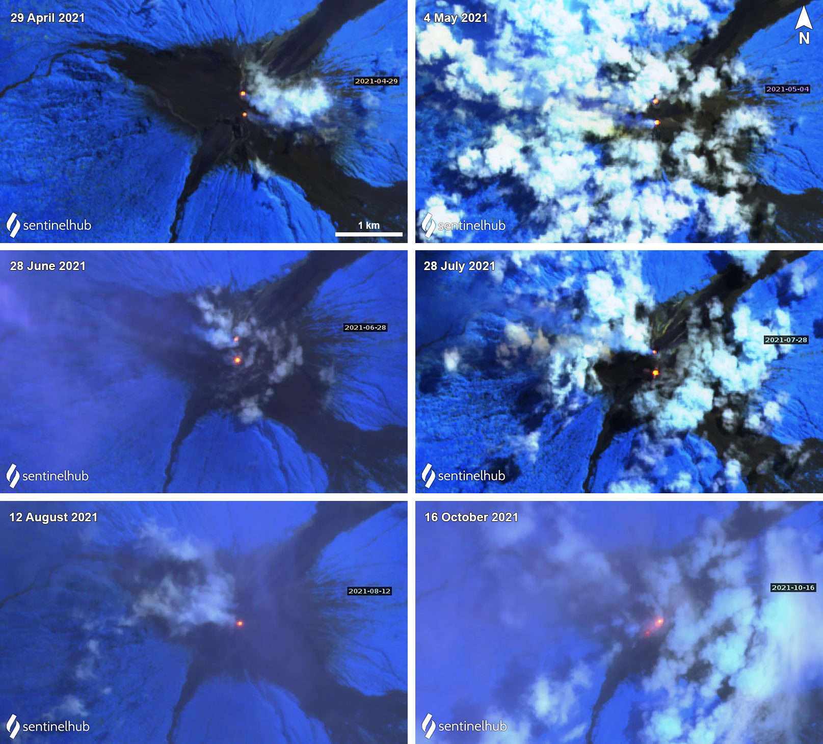 |
Figure 85. Sentinel-2 thermal infrared satellite images show a persistent thermal anomaly (bright yellow-orange) at both of Manam’s summit craters (Main and South) on clear weather days during April through October 2021. Occasional gas-and-steam emissions accompanied the thermal anomalies as seen on 29 April (top left), 4 May (top right), 28 June (middle left), 28 July (middle right), 12 August (bottom left), and 16 October (bottom right) 2021. On 16 October incandescent ejecta was visible rolling down the SW Valley. Sentinel-2 satellite images with “Atmospheric penetration” (bands 12, 11, 8A) rendering. Courtesy of Sentinel Hub Playground. |
Thermal activity during June through October 2021 was frequent and relatively low in power through late August, as recorded by the MIROVA (Middle InfraRed Observation of Volcanic Activity) system. Two brief pulses of stronger anomalies were detected during late August and mid-October (figure 86). A total of 44 thermal alerts were recorded by the MODVOLC thermal algorithm: five in June, five in July, 24 in August, and 10 in October. Two thermal anomalies were identified in Sentinel-2 infrared imagery on clear weather days, one in the Main and one in the South summit craters (figure 85). These were occasionally accompanied by gas-and-steam emissions.
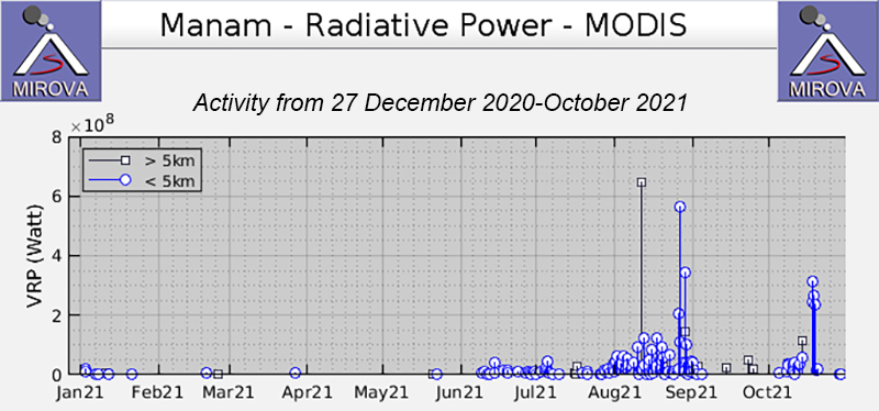 |
Figure 86. Frequent thermal activity at Manam began during early June 2021 and continued through October 2021; the strength of the thermal anomalies increased during late August, as shown on this MIROVA Radiative Power graph. Only a single anomaly was detected during late May. Three stronger anomalies were also recorded during October. Courtesy of MIROVA. |
Information Contacts: Darwin Volcanic Ash Advisory Centre (VAAC), Bureau of Meteorology, Northern Territory Regional Office, PO Box 40050, Casuarina, NT 0811, Australia (URL: http://www.bom.gov.au/info/vaac/); MIROVA (Middle InfraRed Observation of Volcanic Activity), a collaborative project between the Universities of Turin and Florence (Italy) supported by the Centre for Volcanic Risk of the Italian Civil Protection Department (URL: http://www.mirovaweb.it/); NASA Global Sulfur Dioxide Monitoring Page, Atmospheric Chemistry and Dynamics Laboratory, NASA Goddard Space Flight Center (NASA/GSFC), 8800 Greenbelt Road, Goddard, Maryland, USA (URL: https://so2.gsfc.nasa.gov/); Sentinel Hub Playground (URL: https://www.sentinel-hub.com/explore/sentinel-playground); Robert Baim (URL: https://www.facebook.com/robert.baim.7); Norbert Ngasi (URL: https://www.facebook.com/norbert.ngasi.3).
Strong Strombolian explosions and ash plumes during March-April 2022
Manam is located 13 km off the N coast of mainland Papua New Guinea and has had eruptions recorded since 1616. It consists of two active summit craters, Main and South, which occasionally produce Strombolian activity, lava flows, pyroclastic flows, and ash plumes. The current eruption period has been ongoing since 2014. More recent activity included a strong explosion in October 2021, intermittent ash plumes, sulfur dioxide plumes, and thermal anomalies (BGVN 46:11). This report updates activity characterized by Strombolian explosions, strong ash plumes, and thermal activity during November 2021 through July 2022 using information primarily from the Rabaul Volcano Observatory (RVO), the Darwin Volcanic Ash Advisory Center (VAAC), and various satellite data.
Activity was relatively low during November through mid-December 2021 and consisted of intermittent ash plumes and sulfur dioxide plumes (figure 87). Intermittent sulfur dioxide plumes were detected using the TROPOMI instrument on the Sentinel-5P satellite, some of which exceeded at least two Dobson Units (DU) and drifted in different directions. Ash plumes on 3 and 8 November rose to 1.8 km altitude and drifted NW and W, according to HIMAWARI-8 satellite data and weather models from the Darwin VAAC. Ash plumes rose to 6 km altitude and drifted SW on 15 and 16 December, but had dissipated by mid-morning on the 16th. A thermal anomaly was also visible during 14-16 December. Minor ash emissions continued during 16 December, rising to 2.4 km altitude and drifting S, according to an RVO ground report. During 17-18 December ground observers saw a continuous ash plume rise to 3.4 km altitude and drift SE; a hotspot remained visible in satellite imagery. A discrete ash emission rose to 1.5 km altitude and drifted NE at 1600 on 21 December; later that day, discrete ash emissions rose to 3.4 km altitude and drifted SE, and the hotspot remained. Ash plumes may have risen to 10.7 km altitude and drifted S and SW during 0137-0300 on 22 December, though weather clouds and heavy rain obscured satellite views and the plumes were unconfirmed by ground observers. At 1200 later that day, an ash plume rose to 4.9 km altitude and drifted E.
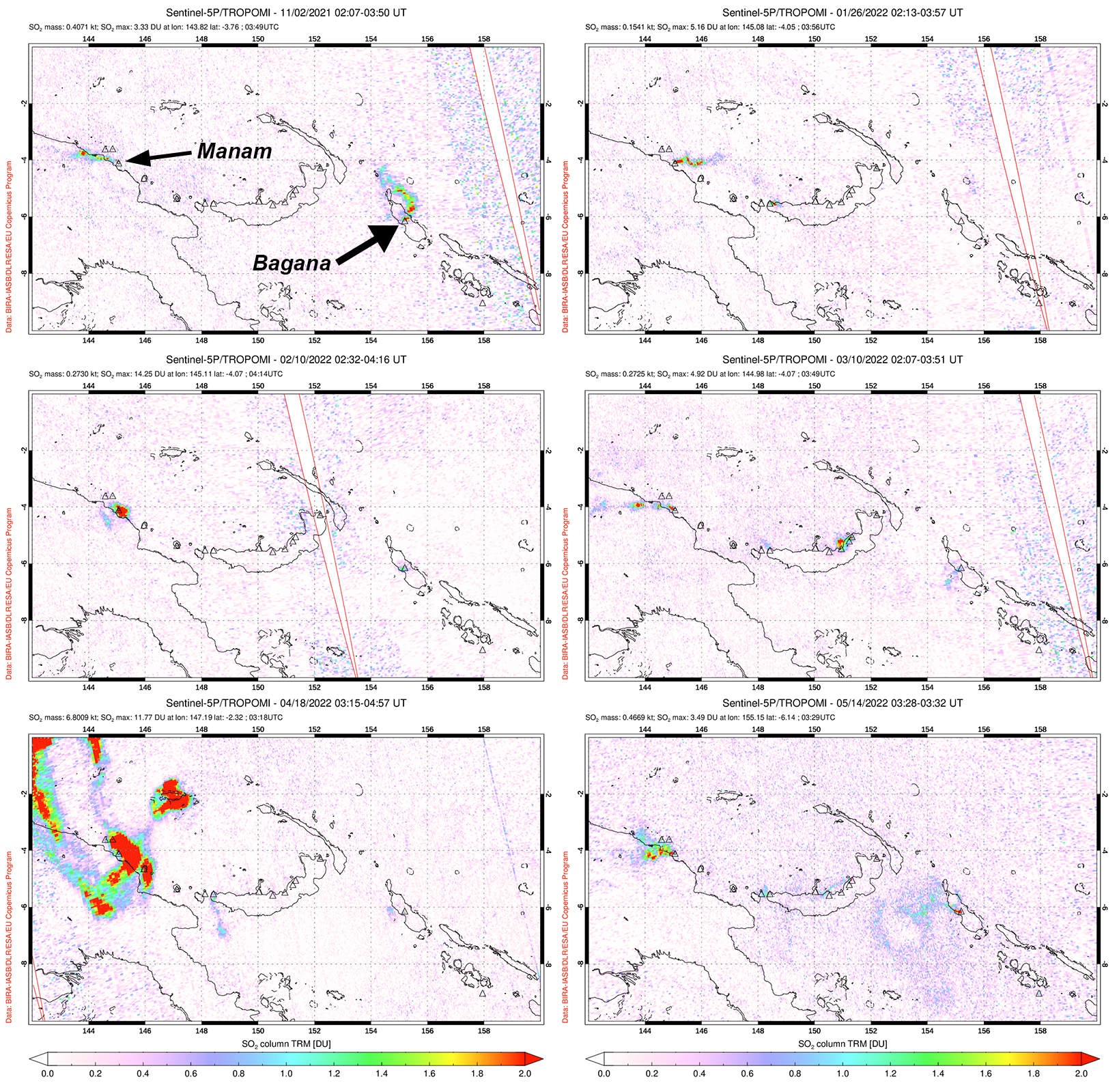 |
Figure 87. Small but distinct sulfur dioxide plumes rising from Manam were detected using data from the TROPOMI instrument on the Sentinel-5P satellite on 2 November 2021 (top left), 26 January 2022 (top right), 10 February 2022 (middle left), 10 March 2022 (middle right), 18 April 2022 (bottom left), and 14 May 2022 (bottom right). Plumes generally drifted in different directions, and the ones shown here exceeded 2 Dobson Units (DU). On 18 April 2022 a strong sulfur dioxide plume was captured above Manam and had a mass of about 6.8 kilotons. Courtesy of the NASA Global Sulfur Dioxide Monitoring Page. |
Stronger activity resumed in March 2022. RVO reported that a small pyroclastic flow was visually observed and recorded in webcam images at 0911 on 8 March. RSAM values increased markedly at 1900, which was reflected in the heightened activity. Minor ash emissions were also observed throughout the day and drifted NW. Intense Strombolian explosions in the South crater observed during 1910-2030 produced loud roaring and rumbling sounds heard on the mainland (22 km SW). Bright summit incandescence and ash emissions were also reported. The Darwin VAAC estimated that on 8 March a high ash plume rose to 15.2 km altitude and drifted W based on RGB satellite imagery. The plume detached from the summit around 2050; lower ash emissions rose to 3 km altitude and continued to extend to the W, though it had dissipated by 0050 on 9 March. The Volcano Alert Level (VAL) was raised to a 3. The next day, staff conducted a field visit and reported no roof collapses or casualties in areas to the NW; vegetation including food crops were covered with ash. After the intense eruption phase at the South crater, white gas-and-steam emissions were visible drifting W. Ash plumes rose to 2.4-3 km altitude and drifted W, SW, and NW during 14-17 March, according to the Darwin VAAC. A thermal anomaly was also detected in RGB satellite imagery on 16 March.
A strong ash plume was also detected in April. On 18 April a high-level ash plume rose to 13.7 km altitude and drifted E and N, according to RVO, RGB and satellite imagery, and weather models. Another ash plume was detected at 2000 that same day and rose to 4.9 km altitude and drifted NE; ash dissipated by 0830 on 19 April. On 30 April a continuous ash emission rose to 2.4 km altitude and drifted E. During May, intermittent ash plumes persisted. RVO reported ash emissions rose to 1.8-2.7 km altitude and drifted SE, ESE, NW, and WNW during 1-7 May, based on satellite imagery and ground reporters. Continuous ash plumes during 13-19 May rose to 2.4-3.7 km altitude and extended SW, W, NE, and NW. Similar ash plumes persisted during 25-29 May and rose to 2.1-2.4 km altitude and drifted in different directions; on 28 May a hotspot was also visible in RGB satellite imagery. An eruptive event at 0657 on 27 May was observed by RVO and webcam images, which produced an ash plume that rose to 2.4 km altitude.
Intermittent ash plumes continued during early June and mid-July. During 1-3 and 5 June ash plumes rose to 2.4-3 km altitude and drifted SW, W, and NW based on ground observations, satellite imagery, and reports from RVO. On 14 July ash plumes rose to 2.1 km altitude and drifted NW, according to satellite and RVO webcam images.
Multiple distinct thermal pulses were recorded during October 2021 through July 2022, as recorded by the MIROVA (Middle InfraRed Observation of Volcanic Activity) system (figure 88). Pulses occurred during October, early December, early January, March, mid-April through May, and July. The pulses in January and March were slightly stronger than the others. A total of 56 thermal anomalies were detected by the MODVOLC thermal alerts system, which occurred near the summit craters on 28 and 30 November 2021, 3, 5, and 21 December 2021, 3, 10, 12, 15, and 16 January 2022, 18 February 2022, 8, 18, and 20 March 2022, 23, 25, and 28 May 2022, and 1, 13, 19, and 23 July 2022. Much of this thermal activity was also captured in Sentinel-2 infrared satellite images on clear weather days, dominantly in the South summit crater, but also occasionally in both the Main and South craters (figure 89). Two thermal anomalies were visible on each of these days: 10 November 2021, 23 February 2022, and 14 April 2022.
 |
Figure 88. Distinct pulses of thermal activity at Manam were recorded during October 2021 through July 2022, as shown in this MIROVA graph (Log Radiative Power). Courtesy of MIROVA. |
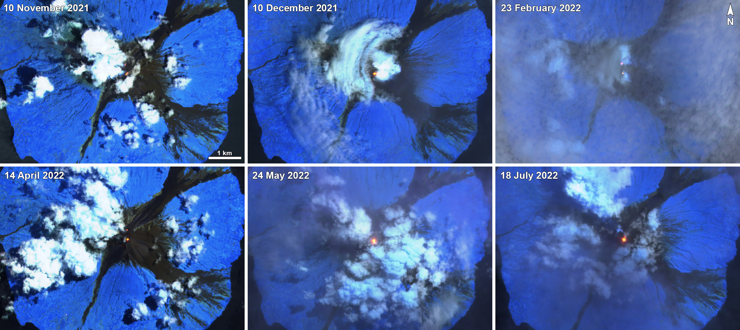 |
Figure 89. Sentinel-2 infrared satellite images show a persistent thermal anomaly (bright yellow-orange) dominantly at the South summit crater on 10 November 2021 (top left), 10 December 2021 (top middle), 23 February 2022 (top right), 14 April 2022 (bottom left), 24 May 2022 (bottom middle), and 18 July 2022 (bottom right). The Main summit crater also showed a thermal hotspot on 10 November 2021, 23 February 2022, and 14 April 2022. Sentinel-2 satellite images with “Atmospheric penetration” (bands 12, 11, 8A) rendering. Courtesy of Sentinel Hub Playground. |
Information Contacts: Rabaul Volcano Observatory (RVO), Geohazards Management Division, Department of Mineral Policy and Geohazards Management (DMPGM), PO Box 3386, Kokopo, East New Britain Province, Papua New Guinea; Darwin Volcanic Ash Advisory Centre (VAAC), Bureau of Meteorology, Northern Territory Regional Office, PO Box 40050, Casuarina, NT 0811, Australia (URL: http://www.bom.gov.au/info/vaac/); MIROVA (Middle InfraRed Observation of Volcanic Activity), a collaborative project between the Universities of Turin and Florence (Italy) supported by the Centre for Volcanic Risk of the Italian Civil Protection Department (URL: http://www.mirovaweb.it/); Hawai'i Institute of Geophysics and Planetology (HIGP) - MODVOLC Thermal Alerts System, School of Ocean and Earth Science and Technology (SOEST), Univ. of Hawai'i, 2525 Correa Road, Honolulu, HI 96822, USA (URL: http://modis.higp.hawaii.edu/); NASA Global Sulfur Dioxide Monitoring Page, Atmospheric Chemistry and Dynamics Laboratory, NASA Goddard Space Flight Center (NASA/GSFC), 8800 Greenbelt Road, Goddard, Maryland, USA (URL: https://so2.gsfc.nasa.gov/); Sentinel Hub Playground (URL: https://www.sentinel-hub.com/explore/sentinel-playground).
Intermittent ash plumes and thermal activity during May-October 2022
Manam is a 10-km-wide island located 13 km off the northern coast of mainland Papua New Guinea. It consists of two active summit craters: the Main summit crater and the South summit crater, although activity is more frequently observed from the South summit crater. Frequent mild-to-moderate eruptions have been recorded since 1616. The current eruption period has been ongoing since June 2014 and has more recently been characterized by strong Strombolian explosions, ash plumes, and thermal activity (BGVN 47:08). This report covers activity during May through October 2022 using information primarily from the Darwin Volcanic Ash Advisory Center (VAAC), and various satellite data.
Intermittent ash plumes were reported by the Darwin VAAC throughout May. Continuous low-level ash plumes during 1-7 May rose to 1.8-2.7 km altitude and drifted SE, NW, ESE, and WNW, based on information from RVO, satellite images, and weather models. On 13 May an eruption was visible in satellite imagery that rose to 3.7 km altitude and drifted SW. A continuous ash plume was still visible in satellite imagery during 14-16 May at 2.4-3.7 km altitude and drifting SW and NE. During 17-19 May ash plumes rose to 2.4 km altitude and drifted NW and W, based on satellite images. Daily ash plumes were reported by the Darwin VAAC during 25-31 May that rose to 2.1-3 km altitude and drifted in different directions. An eruptive event at 0657 on 27 May generated an ash plume that rose to 2.4 km altitude, according to observations from RVO and webcam images.
Low activity was reported during June and July and mainly consisted of occasional ash plumes. During 1-3 and 5 June ash plumes rose to 2.4-3 km altitude and drifted NW, W, and SW, based on satellite and webcam images and information from RVO. On 14 July ash plumes rose to 2.1 km altitude and drifted NW. Activity during August through October was relatively quiet. On 29 October an ash plume rose to 1.5 km altitude and drifted NW; the plume dissipated within three hours.
Occasional sulfur dioxide plumes were detected using the TROPOMI instrument on the Sentinel-5P satellite, some of which exceeded at least two Dobson Units (DU) and drifted in different directions (figure 90). Intermittent low-to-moderate-power thermal anomalies were recorded during May through mid-September, as recorded by the MIROVA (Middle InfraRed Observation of Volcanic Activity) system (figure 91). Thermal activity was particularly strong during late May and early-to-mid-July. A single anomaly was detected during early October. A total of nine thermal hotspots were detected by the MODVOLC thermal alerts system on 23, 25, and 28 May, and 1, 13, 19, and 23 July. On clear weather days some of that stronger thermal activity was captured in Sentinel-2 infrared satellite imagery; the stronger hotspot was detected in the South summit crater, but occasionally, anomalies were visible in both the Main and South craters (figure 92). Distinct anomalies were detected in both the Main and South craters on 17 August, 6 September, and 1 October.
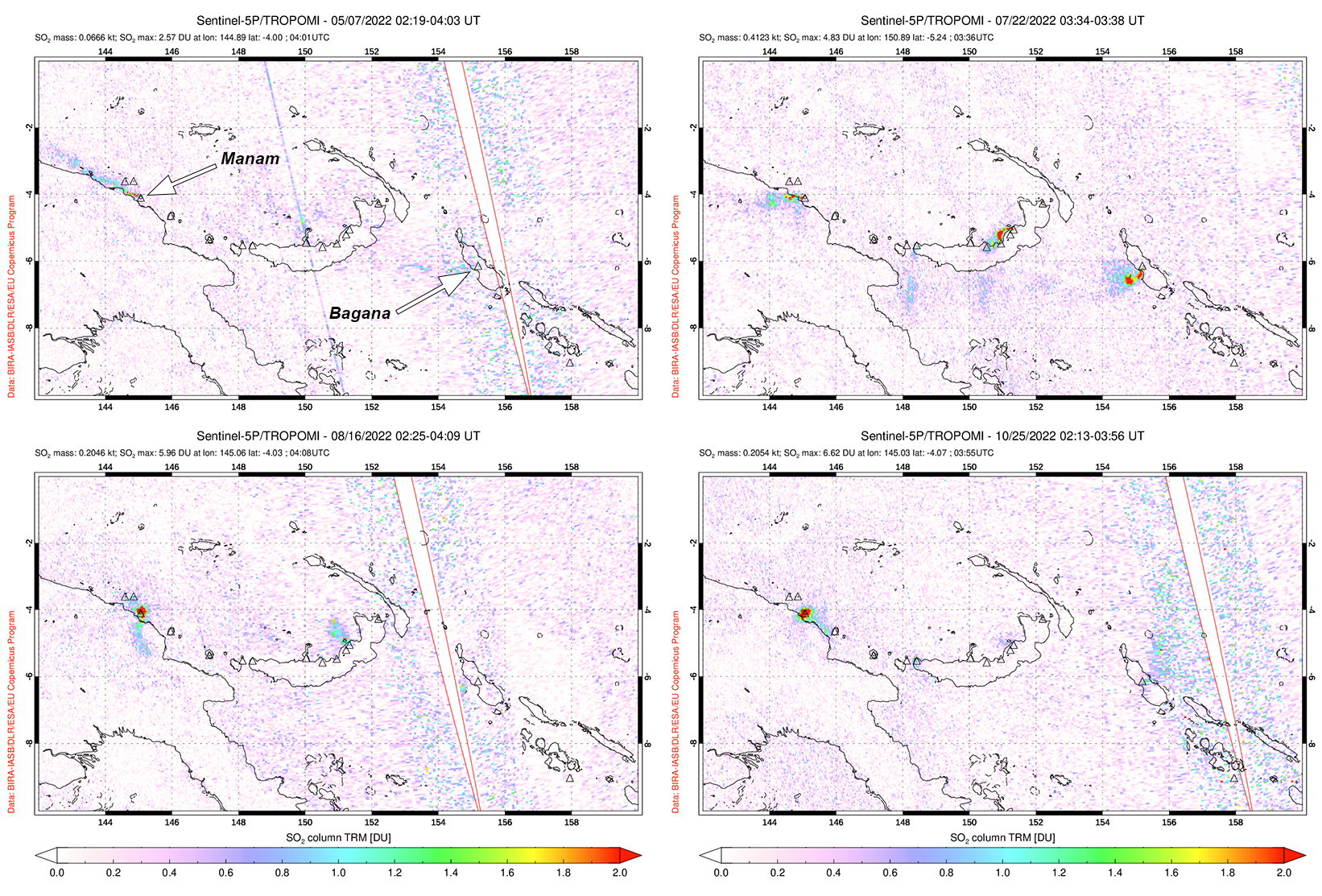 |
Figure 90. Small but distinct sulfur dioxide plumes rising from Manam were detected using data from the TROPOMI instrument on the Sentinel-5P satellite on 7 May 2022 (top left), 22 July 2022 (top right), 16 August 2022 (bottom left), and 25 October 2022 (bottom right). Plumes generally drifted in different directions, and the ones shown here exceeded 2 Dobson Units (DUs). Courtesy of the NASA Global Sulfur Dioxide Monitoring Page. |
 |
Figure 91. Intermittent low-to-moderate-power thermal anomalies were detected at Manam during May through September 2022, as shown in this MIROVA graph (Log Radiative Power). Anomalies were particularly strong during late May and early-to-mid-July. A single anomaly was detected during early October. Courtesy of MIROVA. |
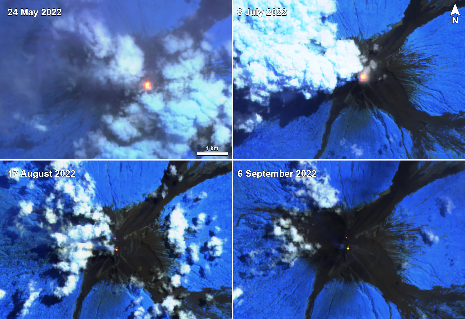 |
Figure 92. Sentinel-2 infrared satellite images show a persistent thermal anomaly (bright yellow-orange) dominantly at the South summit crater on 24 May 2022 (top left), 3 July 2022 (top right), 17 August 2022 (bottom left), and 6 September 2022 (bottom right). The hotspot was notably strong during 24 May and 3 July. The Main summit crater (the northern crater) also showed a hotspot on 17 August and 6 September. Sentinel-2 satellite images with “Atmospheric penetration” (bands 12, 11, 8A) rendering. Courtesy of Sentinel Hub Playground. |
Information Contacts: Rabaul Volcano Observatory (RVO), Geohazards Management Division, Department of Mineral Policy and Geohazards Management (DMPGM), PO Box 3386, Kokopo, East New Britain Province, Papua New Guinea; Darwin Volcanic Ash Advisory Centre (VAAC), Bureau of Meteorology, Northern Territory Regional Office, PO Box 40050, Casuarina, NT 0811, Australia (URL: http://www.bom.gov.au/info/vaac/); MIROVA (Middle InfraRed Observation of Volcanic Activity), a collaborative project between the Universities of Turin and Florence (Italy) supported by the Centre for Volcanic Risk of the Italian Civil Protection Department (URL: http://www.mirovaweb.it/); Hawai'i Institute of Geophysics and Planetology (HIGP) - MODVOLC Thermal Alerts System, School of Ocean and Earth Science and Technology (SOEST), Univ. of Hawai'i, 2525 Correa Road, Honolulu, HI 96822, USA (URL: http://modis.higp.hawaii.edu/); NASA Global Sulfur Dioxide Monitoring Page, Atmospheric Chemistry and Dynamics Laboratory, NASA Goddard Space Flight Center (NASA/GSFC), 8800 Greenbelt Road, Goddard, Maryland, USA (URL: https://so2.gsfc.nasa.gov/); Sentinel Hub Playground (URL: https://www.sentinel-hub.com/explore/sentinel-playground).
Few ash plumes during November-December 2022
Manam is a 10-km-wide island that consists of two active summit craters: the Main summit crater and the South summit crater and is located 13 km off the northern coast of mainland Papua New Guinea. Frequent mild-to-moderate eruptions have been recorded since 1616. The current eruption period began during June 2014 and has more recently been characterized by intermittent ash plumes and thermal activity (BGVN 47:11). This report updates activity that occurred from November 2022 through May 2023 based on information from the Darwin Volcanic Ash Advisory Center (VAAC) and various satellite data.
Ash plumes were reported during November and December 2022 by the Darwin VAAC. On 7 November an ash plume rose to 2.1 km altitude and drifted NE based on satellite images and weather models. On 14 November an ash plume rose to 2.1 km altitude and drifted W based on RVO webcam images. On 20 November ash plumes rose to 1.8 km altitude and drifted NW. On 26 December an ash plume rose to 3 km altitude and drifted S and SSE.
Intermittent sulfur dioxide plumes were detected using the TROPOMI instrument on the Sentinel-5P satellite, some of which exceeded at least two Dobson Units (DU) and drifted in different directions (figure 93). Occasional low-to-moderate power thermal anomalies were recorded by the MIROVA (Middle InfraRed Observation of Volcanic Activity) system; less than five anomalies were recorded each month during November 2022 through May 2023 (figure 94). Two thermal hotspots were detected by the MODVOLC thermal alerts system on 10 December 2022. On clear weather days, thermal activity was also captured in infrared satellite imagery in both the Main and South summit craters, accompanied by gas-and-steam emissions (figure 95).
 |
Figure 93. Distinct sulfur dioxide plumes were captured, rising from Manam based on data from the TROPOMI instrument on the Sentinel-5P satellite on 16 November 2022 (top left), 6 December 2022 (top right), 14 January 2023 (bottom left), and 23 March 2023 (bottom right). Plumes generally drifted in different directions. Courtesy of the NASA Global Sulfur Dioxide Monitoring Page. |
 |
Figure 94. Occasional low-to-moderate power thermal anomalies were detected at Manam during November 2022 through May 2023, as shown in this MIROVA graph (Log Radiative Power). Only three anomalies were detected during late November, one in early December, two during January 2023, one in late March, four during April, and one during late May. Courtesy of MIROVA. |
 |
Figure 95. Infrared (bands B12, B11, B4) satellite images show a consistent thermal anomaly (bright yellow-orange) in both the Main (the northern crater) and South summit craters on 10 November 2022 (top left), 15 December 2022 (top right), 3 February 2023 (bottom left), and 24 April 2023 (bottom right). Gas-and-steam emissions occasionally accompanied the thermal activity. Courtesy of Copernicus Browser. |
Information Contacts: Rabaul Volcano Observatory (RVO), Geohazards Management Division, Department of Mineral Policy and Geohazards Management (DMPGM), PO Box 3386, Kokopo, East New Britain Province, Papua New Guinea; Darwin Volcanic Ash Advisory Centre (VAAC), Bureau of Meteorology, Northern Territory Regional Office, PO Box 40050, Casuarina, NT 0811, Australia (URL: http://www.bom.gov.au/info/vaac/); MIROVA (Middle InfraRed Observation of Volcanic Activity), a collaborative project between the Universities of Turin and Florence (Italy) supported by the Centre for Volcanic Risk of the Italian Civil Protection Department (URL: http://www.mirovaweb.it/); Hawai'i Institute of Geophysics and Planetology (HIGP) - MODVOLC Thermal Alerts System, School of Ocean and Earth Science and Technology (SOEST), Univ. of Hawai'i, 2525 Correa Road, Honolulu, HI 96822, USA (URL: http://modis.higp.hawaii.edu/); NASA Global Sulfur Dioxide Monitoring Page, Atmospheric Chemistry and Dynamics Laboratory, NASA Goddard Space Flight Center (NASA/GSFC), 8800 Greenbelt Road, Goddard, Maryland, USA (URL: https://so2.gsfc.nasa.gov/); Copernicus Browser, Copernicus Data Space Ecosystem, European Space Agency (URL: https://dataspace.copernicus.eu/browser/).
Low thermal activity during January-June 2023
Manam is a 10-km-wide island that consists of two active summit craters: the Main summit crater and the South summit crater and is located 13 km off the northern coast of mainland Papua New Guinea. Frequent mild-to-moderate eruptions have been recorded since 1616. The current eruption period began during June 2014 and has more recently consisted of ash plumes and thermal activity (BGVN 48:07). This report covers activity during January through June 2023 primarily using various satellite data.
Weak and intermittent sulfur dioxide plumes were detected using the TROPOMI instrument on the Sentinel-5P satellite, some of which exceeded at least two Dobson Units (DU) and drifted in different directions (figure 96). Few low-power thermal anomalies were recorded by the MIROVA (Middle InfraRed Observation of Volcanic Activity) system; two anomalies were captured during January, one during late March, one during early April, one during late May, and one during early June (figure 97). On clear weather days, thermal activity was captured in infrared satellite images in both the Main and South summit craters (figure 98).
|
Figure 96. Distinct sulfur dioxide plumes were visible rising above Manam based on data from the TROPOMI instrument on the Sentinel-5P satellite on 23 March 2023 (left) and 15 May 2023 (right). Plumes drifted NE and SE, respectively. Courtesy of the NASA Global Sulfur Dioxide Monitoring Page. |
|
Figure 97. Few thermal low-power thermal anomalies were detected at Manam during January through June 2023, as shown in this MIROVA graph (Log Radiative Power). Two anomalies were captured during January, one during late March, one during early April, one during late May, and one during early June. Courtesy of MIROVA. |
|
Figure 98. Infrared (bands B12, B11, B4) satellite images show a consistent thermal anomaly (bright yellow-orange) in both the Main (the northern crater) and South summit craters on 14 January 2023 (top left), 3 February 2023 (top right), 24 April 2023 (bottom left), and 28 June 2023 (bottom right). The two craters are just under 400 m apart. Gas-and-steam emissions occasionally accompanied the thermal activity. Courtesy of Copernicus Browser. |
Information Contacts: MIROVA (Middle InfraRed Observation of Volcanic Activity), a collaborative project between the Universities of Turin and Florence (Italy) supported by the Centre for Volcanic Risk of the Italian Civil Protection Department (URL: http://www.mirovaweb.it/); NASA Global Sulfur Dioxide Monitoring Page, Atmospheric Chemistry and Dynamics Laboratory, NASA Goddard Space Flight Center (NASA/GSFC), 8800 Greenbelt Road, Goddard, Maryland, USA (URL: https://so2.gsfc.nasa.gov/); Copernicus Browser, Copernicus Data Space Ecosystem, European Space Agency (URL: https://dataspace.copernicus.eu/browser/).
|
|
||||||||||||||||||||||||||
There is data available for 41 confirmed Holocene eruptive periods.
2018 May 10 ± 10 days - 2025 May 2 (continuing) Confirmed Eruption (Explosive / Effusive) VEI: 4
| Episode 1 | Eruption (Explosive / Effusive) | Southern and Main Craters | ||||||||||||||||||||||||||||||||||||||||||||||||||||||||||||||||||||||||||||||||||||||||||||||||||||||||||||||||||||||||||||||||||||||||||||||||||||||||||||||||||||||||||||||||||||||||||||||||||||||||||||||||||||||||||||||||||||||||||||||||||||||||||||||||||||||||||||||||||||||||||||||||||||||||||||||||||||||||||
|---|---|---|---|---|---|---|---|---|---|---|---|---|---|---|---|---|---|---|---|---|---|---|---|---|---|---|---|---|---|---|---|---|---|---|---|---|---|---|---|---|---|---|---|---|---|---|---|---|---|---|---|---|---|---|---|---|---|---|---|---|---|---|---|---|---|---|---|---|---|---|---|---|---|---|---|---|---|---|---|---|---|---|---|---|---|---|---|---|---|---|---|---|---|---|---|---|---|---|---|---|---|---|---|---|---|---|---|---|---|---|---|---|---|---|---|---|---|---|---|---|---|---|---|---|---|---|---|---|---|---|---|---|---|---|---|---|---|---|---|---|---|---|---|---|---|---|---|---|---|---|---|---|---|---|---|---|---|---|---|---|---|---|---|---|---|---|---|---|---|---|---|---|---|---|---|---|---|---|---|---|---|---|---|---|---|---|---|---|---|---|---|---|---|---|---|---|---|---|---|---|---|---|---|---|---|---|---|---|---|---|---|---|---|---|---|---|---|---|---|---|---|---|---|---|---|---|---|---|---|---|---|---|---|---|---|---|---|---|---|---|---|---|---|---|---|---|---|---|---|---|---|---|---|---|---|---|---|---|---|---|---|---|---|---|---|---|---|---|---|---|---|---|---|---|---|---|---|---|---|---|---|---|---|---|---|---|---|---|---|---|---|---|---|---|---|---|---|---|---|---|---|---|---|---|---|---|---|---|---|---|---|---|---|---|---|
| 2018 May 10 ± 10 days - 2025 May 2 (continuing) | Evidence from Observations: Satellite (infrared) | ||||||||||||||||||||||||||||||||||||||||||||||||||||||||||||||||||||||||||||||||||||||||||||||||||||||||||||||||||||||||||||||||||||||||||||||||||||||||||||||||||||||||||||||||||||||||||||||||||||||||||||||||||||||||||||||||||||||||||||||||||||||||||||||||||||||||||||||||||||||||||||||||||||||||||||||||||||||||||
|
List of 61 Events for Episode 1 at Southern and Main Craters
|
|||||||||||||||||||||||||||||||||||||||||||||||||||||||||||||||||||||||||||||||||||||||||||||||||||||||||||||||||||||||||||||||||||||||||||||||||||||||||||||||||||||||||||||||||||||||||||||||||||||||||||||||||||||||||||||||||||||||||||||||||||||||||||||||||||||||||||||||||||||||||||||||||||||||||||||||||||||||||||
[ 2014 Jun 29 - 2018 Jan 10 ± 3 days ] Confirmed Eruption Uncertain Eruption
| Episode 1 | Eruption (Explosive / Effusive) | Southern and Main craters | |||||||||||||||||||||||||||||||||||||||||||||||||||||||||||||||||||||||||||||||||||||||||||||||||||||||||||||||||||||||||||||||||||||||||||||||||||||||||||||||||||||||||||||||||||||||||||||||||||||||||||||||||||||||||||||||||||||
|---|---|---|---|---|---|---|---|---|---|---|---|---|---|---|---|---|---|---|---|---|---|---|---|---|---|---|---|---|---|---|---|---|---|---|---|---|---|---|---|---|---|---|---|---|---|---|---|---|---|---|---|---|---|---|---|---|---|---|---|---|---|---|---|---|---|---|---|---|---|---|---|---|---|---|---|---|---|---|---|---|---|---|---|---|---|---|---|---|---|---|---|---|---|---|---|---|---|---|---|---|---|---|---|---|---|---|---|---|---|---|---|---|---|---|---|---|---|---|---|---|---|---|---|---|---|---|---|---|---|---|---|---|---|---|---|---|---|---|---|---|---|---|---|---|---|---|---|---|---|---|---|---|---|---|---|---|---|---|---|---|---|---|---|---|---|---|---|---|---|---|---|---|---|---|---|---|---|---|---|---|---|---|---|---|---|---|---|---|---|---|---|---|---|---|---|---|---|---|---|---|---|---|---|---|---|---|---|---|---|---|---|---|---|---|---|---|---|---|---|---|---|---|---|---|---|---|---|---|---|---|
| 2014 Jun 29 - 2015 Oct 29 | Evidence from Observations: Reported | |||||||||||||||||||||||||||||||||||||||||||||||||||||||||||||||||||||||||||||||||||||||||||||||||||||||||||||||||||||||||||||||||||||||||||||||||||||||||||||||||||||||||||||||||||||||||||||||||||||||||||||||||||||||||||||||||||||
|
List of 44 Events for Episode 1 at Southern and Main craters
|
||||||||||||||||||||||||||||||||||||||||||||||||||||||||||||||||||||||||||||||||||||||||||||||||||||||||||||||||||||||||||||||||||||||||||||||||||||||||||||||||||||||||||||||||||||||||||||||||||||||||||||||||||||||||||||||||||||||
| Episode 2 | Eruption (Explosive / Effusive) | Summit craters | |||||||||||||||||||||||||||||||||||||||||||||||||||||||||||||||||||||||||||||||||||||||||||||||||||||||||||||||||||||||
|---|---|---|---|---|---|---|---|---|---|---|---|---|---|---|---|---|---|---|---|---|---|---|---|---|---|---|---|---|---|---|---|---|---|---|---|---|---|---|---|---|---|---|---|---|---|---|---|---|---|---|---|---|---|---|---|---|---|---|---|---|---|---|---|---|---|---|---|---|---|---|---|---|---|---|---|---|---|---|---|---|---|---|---|---|---|---|---|---|---|---|---|---|---|---|---|---|---|---|---|---|---|---|---|---|---|---|---|---|---|---|---|---|---|---|---|---|---|---|---|---|
| 2016 Jan 29 ± 2 days - 2016 Oct 6 | Evidence from Observations: Satellite (infrared) | |||||||||||||||||||||||||||||||||||||||||||||||||||||||||||||||||||||||||||||||||||||||||||||||||||||||||||||||||||||||
|
List of 22 Events for Episode 2 at Summit craters
|
||||||||||||||||||||||||||||||||||||||||||||||||||||||||||||||||||||||||||||||||||||||||||||||||||||||||||||||||||||||||
| Episode 3 | Eruption (Explosive / Effusive) | Main and Southern craters | ||||||||||||||||||||||||||||||||||||||||||||||||||||||||||||||||||||||||||||||||||||||||||||||||||||||||||||||||||||||||||||||||||||||||||||||||||||||||||||||||||||||||||||||||||||||||||||||||||||||||||||||||||||||||||||||||||||||||||||||||||||||||||||||||||||||||||||||||||||||||||||||||||||||||||||||||||||||||||||||||||||||||||||||||||||||||||||||||||||||||||||||||||||||||||||||||||||||||||||||||||||||||||||||||||||||||
|---|---|---|---|---|---|---|---|---|---|---|---|---|---|---|---|---|---|---|---|---|---|---|---|---|---|---|---|---|---|---|---|---|---|---|---|---|---|---|---|---|---|---|---|---|---|---|---|---|---|---|---|---|---|---|---|---|---|---|---|---|---|---|---|---|---|---|---|---|---|---|---|---|---|---|---|---|---|---|---|---|---|---|---|---|---|---|---|---|---|---|---|---|---|---|---|---|---|---|---|---|---|---|---|---|---|---|---|---|---|---|---|---|---|---|---|---|---|---|---|---|---|---|---|---|---|---|---|---|---|---|---|---|---|---|---|---|---|---|---|---|---|---|---|---|---|---|---|---|---|---|---|---|---|---|---|---|---|---|---|---|---|---|---|---|---|---|---|---|---|---|---|---|---|---|---|---|---|---|---|---|---|---|---|---|---|---|---|---|---|---|---|---|---|---|---|---|---|---|---|---|---|---|---|---|---|---|---|---|---|---|---|---|---|---|---|---|---|---|---|---|---|---|---|---|---|---|---|---|---|---|---|---|---|---|---|---|---|---|---|---|---|---|---|---|---|---|---|---|---|---|---|---|---|---|---|---|---|---|---|---|---|---|---|---|---|---|---|---|---|---|---|---|---|---|---|---|---|---|---|---|---|---|---|---|---|---|---|---|---|---|---|---|---|---|---|---|---|---|---|---|---|---|---|---|---|---|---|---|---|---|---|---|---|---|---|---|---|---|---|---|---|---|---|---|---|---|---|---|---|---|---|---|---|---|---|---|---|---|---|---|---|---|---|---|---|---|---|---|---|---|---|---|---|---|---|---|---|---|---|---|---|---|---|---|---|---|---|---|---|---|---|---|---|---|---|---|---|---|---|---|---|---|---|---|---|---|---|---|---|---|---|---|---|---|---|---|---|---|---|---|---|---|---|---|---|---|---|---|---|---|---|---|---|---|---|---|---|---|---|---|---|---|---|---|---|
| 2017 Jan 15 ± 2 days - 2017 Sep 2 (on or after) | Evidence from Observations: Reported | ||||||||||||||||||||||||||||||||||||||||||||||||||||||||||||||||||||||||||||||||||||||||||||||||||||||||||||||||||||||||||||||||||||||||||||||||||||||||||||||||||||||||||||||||||||||||||||||||||||||||||||||||||||||||||||||||||||||||||||||||||||||||||||||||||||||||||||||||||||||||||||||||||||||||||||||||||||||||||||||||||||||||||||||||||||||||||||||||||||||||||||||||||||||||||||||||||||||||||||||||||||||||||||||||||||||||
|
List of 83 Events for Episode 3 at Main and Southern craters
|
|||||||||||||||||||||||||||||||||||||||||||||||||||||||||||||||||||||||||||||||||||||||||||||||||||||||||||||||||||||||||||||||||||||||||||||||||||||||||||||||||||||||||||||||||||||||||||||||||||||||||||||||||||||||||||||||||||||||||||||||||||||||||||||||||||||||||||||||||||||||||||||||||||||||||||||||||||||||||||||||||||||||||||||||||||||||||||||||||||||||||||||||||||||||||||||||||||||||||||||||||||||||||||||||||||||||||
| Episode 4 | Uncertain | Main and Southern craters | |||||||||||||||||||||||||||||
|---|---|---|---|---|---|---|---|---|---|---|---|---|---|---|---|---|---|---|---|---|---|---|---|---|---|---|---|---|---|---|
| 2017 Dec 20 (on or after) - 2018 Jan 10 ± 3 days | Evidence from Observations: Satellite (infrared) | |||||||||||||||||||||||||||||
|
List of 4 Events for Episode 4 at Main and Southern craters
|
||||||||||||||||||||||||||||||
2010 Aug 10 (?) - 2013 Dec 15 (on or after) Confirmed Eruption (Explosive / Effusive) VEI: 3
| Episode 1 | Eruption (Explosive / Effusive) | South Crater, Main Crater | ||||||||||||||||||||||||||||||||||||||||||||||||||||||||||||||||||||||||||||||||||||||||||||||||||||||||||||||||||||||||||||||||||||||||||||||||||||||||||||||||||||||||||||||||||||||||||||||||||||||||||||||||||||||||||||||||||||||||||||||||||||||||||||||||||||||||||||||||||||||||||||||||||||||||||||||||||||||||||||||||||||||||||||||||||||||||||||||||||||||||||||||||||||||||||||||||||||||||||||||||||||||||||||||||||||||||||||||||||||||||||||||||||||||||||||||||||||||||||||||||||||||||||||||||||||||||||||||||||||||||||||||||||||||||||||||||||||||||||||||||||||||||||||||||||||||||||||||||||||||||||||||||||||||||||||||||||||||||||||||||||||||||||||||||||||||||||||||||||||||||||||||||||||||||||||||||||||||||||||||||||||||||||||||||||||||||||||||||||||||||||||||||||||||||||||||||||||||||||||||||||||||||||||||||||||||||||||||||||||||||||||||||||||||||||||||||||||||||||||||||||||||||||||||||||||||||||||||||||||||||||||||||||||||||||||||||||||||||||||||||||||||||||||||||||||||||||||||||||||||
|---|---|---|---|---|---|---|---|---|---|---|---|---|---|---|---|---|---|---|---|---|---|---|---|---|---|---|---|---|---|---|---|---|---|---|---|---|---|---|---|---|---|---|---|---|---|---|---|---|---|---|---|---|---|---|---|---|---|---|---|---|---|---|---|---|---|---|---|---|---|---|---|---|---|---|---|---|---|---|---|---|---|---|---|---|---|---|---|---|---|---|---|---|---|---|---|---|---|---|---|---|---|---|---|---|---|---|---|---|---|---|---|---|---|---|---|---|---|---|---|---|---|---|---|---|---|---|---|---|---|---|---|---|---|---|---|---|---|---|---|---|---|---|---|---|---|---|---|---|---|---|---|---|---|---|---|---|---|---|---|---|---|---|---|---|---|---|---|---|---|---|---|---|---|---|---|---|---|---|---|---|---|---|---|---|---|---|---|---|---|---|---|---|---|---|---|---|---|---|---|---|---|---|---|---|---|---|---|---|---|---|---|---|---|---|---|---|---|---|---|---|---|---|---|---|---|---|---|---|---|---|---|---|---|---|---|---|---|---|---|---|---|---|---|---|---|---|---|---|---|---|---|---|---|---|---|---|---|---|---|---|---|---|---|---|---|---|---|---|---|---|---|---|---|---|---|---|---|---|---|---|---|---|---|---|---|---|---|---|---|---|---|---|---|---|---|---|---|---|---|---|---|---|---|---|---|---|---|---|---|---|---|---|---|---|---|---|---|---|---|---|---|---|---|---|---|---|---|---|---|---|---|---|---|---|---|---|---|---|---|---|---|---|---|---|---|---|---|---|---|---|---|---|---|---|---|---|---|---|---|---|---|---|---|---|---|---|---|---|---|---|---|---|---|---|---|---|---|---|---|---|---|---|---|---|---|---|---|---|---|---|---|---|---|---|---|---|---|---|---|---|---|---|---|---|---|---|---|---|---|---|---|---|---|---|---|---|---|---|---|---|---|---|---|---|---|---|---|---|---|---|---|---|---|---|---|---|---|---|---|---|---|---|---|---|---|---|---|---|---|---|---|---|---|---|---|---|---|---|---|---|---|---|---|---|---|---|---|---|---|---|---|---|---|---|---|---|---|---|---|---|---|---|---|---|---|---|---|---|---|---|---|---|---|---|---|---|---|---|---|---|---|---|---|---|---|---|---|---|---|---|---|---|---|---|---|---|---|---|---|---|---|---|---|---|---|---|---|---|---|---|---|---|---|---|---|---|---|---|---|---|---|---|---|---|---|---|---|---|---|---|---|---|---|---|---|---|---|---|---|---|---|---|---|---|---|---|---|---|---|---|---|---|---|---|---|---|---|---|---|---|---|---|---|---|---|---|---|---|---|---|---|---|---|---|---|---|---|---|---|---|---|---|---|---|---|---|---|---|---|---|---|---|---|---|---|---|---|---|---|---|---|---|---|---|---|---|---|---|---|---|---|---|---|---|---|---|---|---|---|---|---|---|---|---|---|---|---|---|---|---|---|---|---|---|---|---|---|---|---|---|---|---|---|---|---|---|---|---|---|---|---|---|---|---|---|---|---|---|---|---|---|---|---|---|---|---|---|---|---|---|---|---|---|---|---|---|---|---|---|---|---|---|---|---|---|---|---|---|---|---|---|---|---|---|---|---|---|---|---|---|---|---|---|---|---|---|---|---|---|---|---|---|---|---|---|---|---|---|---|---|---|---|---|---|---|---|---|---|---|---|---|---|---|---|---|---|---|---|---|---|---|---|---|---|---|---|---|---|---|---|---|---|---|---|---|---|---|---|---|---|---|---|---|---|---|---|---|---|---|---|---|---|---|---|---|---|---|---|---|---|---|---|---|---|---|---|---|---|---|---|---|---|---|---|---|---|---|---|---|---|---|---|---|---|---|---|---|---|---|---|---|---|---|---|---|---|---|---|---|---|---|---|---|---|---|---|---|---|---|---|---|---|---|---|---|---|---|---|---|---|---|---|---|---|---|---|---|---|---|---|---|---|---|---|---|---|---|---|---|---|---|---|---|---|---|---|---|---|---|---|---|---|---|---|---|---|---|---|---|---|---|---|---|---|---|---|---|---|---|---|---|---|---|---|---|---|---|---|---|---|---|---|---|---|---|---|---|---|---|---|---|---|---|---|---|---|---|---|---|---|---|---|---|---|---|---|---|---|---|---|---|---|---|---|---|---|---|---|---|---|---|---|---|---|---|---|---|---|---|---|---|---|---|---|---|---|---|---|---|---|---|---|---|---|---|---|---|---|---|---|---|---|---|---|---|---|---|---|---|
| 2010 Aug 10 (?) - 2013 Dec 15 (on or after) | Evidence from Observations: Reported | ||||||||||||||||||||||||||||||||||||||||||||||||||||||||||||||||||||||||||||||||||||||||||||||||||||||||||||||||||||||||||||||||||||||||||||||||||||||||||||||||||||||||||||||||||||||||||||||||||||||||||||||||||||||||||||||||||||||||||||||||||||||||||||||||||||||||||||||||||||||||||||||||||||||||||||||||||||||||||||||||||||||||||||||||||||||||||||||||||||||||||||||||||||||||||||||||||||||||||||||||||||||||||||||||||||||||||||||||||||||||||||||||||||||||||||||||||||||||||||||||||||||||||||||||||||||||||||||||||||||||||||||||||||||||||||||||||||||||||||||||||||||||||||||||||||||||||||||||||||||||||||||||||||||||||||||||||||||||||||||||||||||||||||||||||||||||||||||||||||||||||||||||||||||||||||||||||||||||||||||||||||||||||||||||||||||||||||||||||||||||||||||||||||||||||||||||||||||||||||||||||||||||||||||||||||||||||||||||||||||||||||||||||||||||||||||||||||||||||||||||||||||||||||||||||||||||||||||||||||||||||||||||||||||||||||||||||||||||||||||||||||||||||||||||||||||||||||||||||||||
|
List of 246 Events for Episode 1 at South Crater, Main Crater
|
|||||||||||||||||||||||||||||||||||||||||||||||||||||||||||||||||||||||||||||||||||||||||||||||||||||||||||||||||||||||||||||||||||||||||||||||||||||||||||||||||||||||||||||||||||||||||||||||||||||||||||||||||||||||||||||||||||||||||||||||||||||||||||||||||||||||||||||||||||||||||||||||||||||||||||||||||||||||||||||||||||||||||||||||||||||||||||||||||||||||||||||||||||||||||||||||||||||||||||||||||||||||||||||||||||||||||||||||||||||||||||||||||||||||||||||||||||||||||||||||||||||||||||||||||||||||||||||||||||||||||||||||||||||||||||||||||||||||||||||||||||||||||||||||||||||||||||||||||||||||||||||||||||||||||||||||||||||||||||||||||||||||||||||||||||||||||||||||||||||||||||||||||||||||||||||||||||||||||||||||||||||||||||||||||||||||||||||||||||||||||||||||||||||||||||||||||||||||||||||||||||||||||||||||||||||||||||||||||||||||||||||||||||||||||||||||||||||||||||||||||||||||||||||||||||||||||||||||||||||||||||||||||||||||||||||||||||||||||||||||||||||||||||||||||||||||||||||||||||||||
2004 Oct 24 - 2009 Dec 12 (?) Confirmed Eruption (Explosive / Effusive) VEI: 4 (?)
| Episode 1 | Eruption (Explosive / Effusive) | South Crater, Main Crater | |||||||||||||||||||||||||||||||||||||||||||||||||||||||||||||||||||||||||||||||||||||||||||||||||||||||||||||
|---|---|---|---|---|---|---|---|---|---|---|---|---|---|---|---|---|---|---|---|---|---|---|---|---|---|---|---|---|---|---|---|---|---|---|---|---|---|---|---|---|---|---|---|---|---|---|---|---|---|---|---|---|---|---|---|---|---|---|---|---|---|---|---|---|---|---|---|---|---|---|---|---|---|---|---|---|---|---|---|---|---|---|---|---|---|---|---|---|---|---|---|---|---|---|---|---|---|---|---|---|---|---|---|---|---|---|---|---|---|---|
| 2004 Oct 24 - 2009 Dec 12 (?) | Evidence from Observations: Reported | |||||||||||||||||||||||||||||||||||||||||||||||||||||||||||||||||||||||||||||||||||||||||||||||||||||||||||||
|
List of 20 Events for Episode 1 at South Crater, Main Crater
|
||||||||||||||||||||||||||||||||||||||||||||||||||||||||||||||||||||||||||||||||||||||||||||||||||||||||||||||
2003 Oct 26 ± 5 days - 2004 Mar 28 Confirmed Eruption (Explosive / Effusive) VEI: 1
| Episode 1 | Eruption (Explosive / Effusive) | Main Crater | ||||||||||||||||||||||||||||||||||
|---|---|---|---|---|---|---|---|---|---|---|---|---|---|---|---|---|---|---|---|---|---|---|---|---|---|---|---|---|---|---|---|---|---|---|---|
| 2003 Oct 26 ± 5 days - 2004 Mar 28 | Evidence from Observations: Reported | ||||||||||||||||||||||||||||||||||
|
List of 5 Events for Episode 1 at Main Crater
|
|||||||||||||||||||||||||||||||||||
2003 May 17 - 2003 May 23 Confirmed Eruption (Explosive / Effusive) VEI: 1
| Episode 1 | Eruption (Explosive / Effusive) | Main Crater | |||||||||||||||||||||||||||||
|---|---|---|---|---|---|---|---|---|---|---|---|---|---|---|---|---|---|---|---|---|---|---|---|---|---|---|---|---|---|---|
| 2003 May 17 - 2003 May 23 | Evidence from Observations: Reported | |||||||||||||||||||||||||||||
|
List of 4 Events for Episode 1 at Main Crater
|
||||||||||||||||||||||||||||||
2002 Oct 31 Confirmed Eruption (Explosive / Effusive) VEI: 2
| Episode 1 | Eruption (Explosive / Effusive) | |||||||||||||||||||||||||
|---|---|---|---|---|---|---|---|---|---|---|---|---|---|---|---|---|---|---|---|---|---|---|---|---|---|
| 2002 Oct 31 - Unknown | Evidence from Observations: Reported | ||||||||||||||||||||||||
|
List of 3 Events for Episode 1
|
|||||||||||||||||||||||||
2002 Jan 13 - 2002 May 21 Confirmed Eruption (Explosive / Effusive) VEI: 3 (?)
| Episode 1 | Eruption (Explosive / Effusive) | South Crater | ||||||||||||||||||||||||||||||||||
|---|---|---|---|---|---|---|---|---|---|---|---|---|---|---|---|---|---|---|---|---|---|---|---|---|---|---|---|---|---|---|---|---|---|---|---|
| 2002 Jan 13 - 2002 May 21 | Evidence from Observations: Reported | ||||||||||||||||||||||||||||||||||
|
List of 5 Events for Episode 1 at South Crater
|
|||||||||||||||||||||||||||||||||||
2001 Jun 14 - 2001 Jun 25 (?) Confirmed Eruption (Explosive / Effusive) VEI: 2
| Episode 1 | Eruption (Explosive / Effusive) | |||||||||||||||||||||||||
|---|---|---|---|---|---|---|---|---|---|---|---|---|---|---|---|---|---|---|---|---|---|---|---|---|---|
| 2001 Jun 14 - 2001 Jun 25 (?) | Evidence from Observations: Reported | ||||||||||||||||||||||||
|
List of 3 Events for Episode 1
|
|||||||||||||||||||||||||
2000 Jun 3 - 2000 Jun 4 Confirmed Eruption (Explosive / Effusive) VEI: 2
| Episode 1 | Eruption (Explosive / Effusive) | South Crater | ||||||||||||||||||||||||||||||||||||||||||||||||||||||
|---|---|---|---|---|---|---|---|---|---|---|---|---|---|---|---|---|---|---|---|---|---|---|---|---|---|---|---|---|---|---|---|---|---|---|---|---|---|---|---|---|---|---|---|---|---|---|---|---|---|---|---|---|---|---|---|
| 2000 Jun 3 - 2000 Jun 4 | Evidence from Observations: Reported | ||||||||||||||||||||||||||||||||||||||||||||||||||||||
|
List of 9 Events for Episode 1 at South Crater
|
|||||||||||||||||||||||||||||||||||||||||||||||||||||||
1974 Mar 4 (?) - 1999 Nov 9 (?) Confirmed Eruption (Explosive / Effusive) VEI: 3
| Episode 1 | Eruption (Explosive / Effusive) | South Crater, Main Crater | |||||||||||||||||||||||||||||||||||||||||||||||||||||||||||||||||||||||||||||||||||||||||||||||||||||||||||||||||||||||
|---|---|---|---|---|---|---|---|---|---|---|---|---|---|---|---|---|---|---|---|---|---|---|---|---|---|---|---|---|---|---|---|---|---|---|---|---|---|---|---|---|---|---|---|---|---|---|---|---|---|---|---|---|---|---|---|---|---|---|---|---|---|---|---|---|---|---|---|---|---|---|---|---|---|---|---|---|---|---|---|---|---|---|---|---|---|---|---|---|---|---|---|---|---|---|---|---|---|---|---|---|---|---|---|---|---|---|---|---|---|---|---|---|---|---|---|---|---|---|---|---|
| 1974 Mar 4 (?) - 1999 Nov 9 (?) | Evidence from Observations: Reported | |||||||||||||||||||||||||||||||||||||||||||||||||||||||||||||||||||||||||||||||||||||||||||||||||||||||||||||||||||||||
|
List of 22 Events for Episode 1 at South Crater, Main Crater
|
||||||||||||||||||||||||||||||||||||||||||||||||||||||||||||||||||||||||||||||||||||||||||||||||||||||||||||||||||||||||
1965 Jul 2 ± 182 days - 1966 Jan 25 (on or after) Confirmed Eruption (Explosive / Effusive) VEI: 2
| Episode 1 | Eruption (Explosive / Effusive) | South Crater | ||||||||||||||||||||||||||||||||||
|---|---|---|---|---|---|---|---|---|---|---|---|---|---|---|---|---|---|---|---|---|---|---|---|---|---|---|---|---|---|---|---|---|---|---|---|
| 1965 Jul 2 ± 182 days - 1966 Jan 25 (on or after) | Evidence from Observations: Reported | ||||||||||||||||||||||||||||||||||
|
List of 5 Events for Episode 1 at South Crater
|
|||||||||||||||||||||||||||||||||||
1963 Nov 26 - 1964 Apr 16 ± 15 days Confirmed Eruption (Explosive / Effusive) VEI: 2
| Episode 1 | Eruption (Explosive / Effusive) | South Crater | |||||||||||||||||||||||||||||||||||||||
|---|---|---|---|---|---|---|---|---|---|---|---|---|---|---|---|---|---|---|---|---|---|---|---|---|---|---|---|---|---|---|---|---|---|---|---|---|---|---|---|---|
| 1963 Nov 26 - 1964 Apr 16 ± 15 days | Evidence from Observations: Reported | |||||||||||||||||||||||||||||||||||||||
|
List of 6 Events for Episode 1 at South Crater
|
||||||||||||||||||||||||||||||||||||||||
1963 Feb 15 ± 14 days - 1963 May 8 (on or after) Confirmed Eruption (Explosive / Effusive) VEI: 2
| Episode 1 | Eruption (Explosive / Effusive) | South Crater | ||||||||||||||||||||||||
|---|---|---|---|---|---|---|---|---|---|---|---|---|---|---|---|---|---|---|---|---|---|---|---|---|---|
| 1963 Feb 15 ± 14 days - 1963 May 8 (on or after) | Evidence from Observations: Reported | ||||||||||||||||||||||||
|
List of 3 Events for Episode 1 at South Crater
|
|||||||||||||||||||||||||
1962 Apr 16 ± 15 days Confirmed Eruption (Explosive / Effusive) VEI: 2
| Episode 1 | Eruption (Explosive / Effusive) | South Crater | ||||||||||||||||||||||||
|---|---|---|---|---|---|---|---|---|---|---|---|---|---|---|---|---|---|---|---|---|---|---|---|---|---|
| 1962 Apr 16 ± 15 days - Unknown | Evidence from Observations: Reported | ||||||||||||||||||||||||
|
List of 3 Events for Episode 1 at South Crater
|
|||||||||||||||||||||||||
1961 Jul 16 ± 15 days - 1961 Sep 16 ± 15 days Confirmed Eruption (Explosive / Effusive) VEI: 2
| Episode 1 | Eruption (Explosive / Effusive) | South Crater | ||||||||||||||||||||||||
|---|---|---|---|---|---|---|---|---|---|---|---|---|---|---|---|---|---|---|---|---|---|---|---|---|---|
| 1961 Jul 16 ± 15 days - 1961 Sep 16 ± 15 days | Evidence from Observations: Reported | ||||||||||||||||||||||||
|
List of 3 Events for Episode 1 at South Crater
|
|||||||||||||||||||||||||
1959 Dec 16 ± 15 days - 1960 Dec 16 (on or after) ± 15 days Confirmed Eruption (Explosive / Effusive) VEI: 2
| Episode 1 | Eruption (Explosive / Effusive) | Main Crater, South Crater | ||||||||||||||||||||||||||||||||||||||||||||||||||||||
|---|---|---|---|---|---|---|---|---|---|---|---|---|---|---|---|---|---|---|---|---|---|---|---|---|---|---|---|---|---|---|---|---|---|---|---|---|---|---|---|---|---|---|---|---|---|---|---|---|---|---|---|---|---|---|---|
| 1959 Dec 16 ± 15 days - 1960 Dec 16 (on or after) ± 15 days | Evidence from Observations: Reported | ||||||||||||||||||||||||||||||||||||||||||||||||||||||
|
List of 9 Events for Episode 1 at Main Crater, South Crater
|
|||||||||||||||||||||||||||||||||||||||||||||||||||||||
1959 Jun 16 ± 15 days - 1959 Jul 16 ± 15 days Confirmed Eruption (Explosive / Effusive) VEI: 2
| Episode 1 | Eruption (Explosive / Effusive) | South Crater | |||||||||||||||||||
|---|---|---|---|---|---|---|---|---|---|---|---|---|---|---|---|---|---|---|---|---|
| 1959 Jun 16 ± 15 days - 1959 Jul 16 ± 15 days | Evidence from Observations: Reported | |||||||||||||||||||
|
List of 2 Events for Episode 1 at South Crater
|
||||||||||||||||||||
1956 Dec 8 - 1958 Aug 16 ± 15 days Confirmed Eruption (Explosive / Effusive) VEI: 3
| Episode 1 | Eruption (Explosive / Effusive) | South Crater, Main Crater | ||||||||||||||||||||||||||||||||||||||||||||||||||||||||||||||||||||||||||||||||||||||||||||||||||||||||||||||||||
|---|---|---|---|---|---|---|---|---|---|---|---|---|---|---|---|---|---|---|---|---|---|---|---|---|---|---|---|---|---|---|---|---|---|---|---|---|---|---|---|---|---|---|---|---|---|---|---|---|---|---|---|---|---|---|---|---|---|---|---|---|---|---|---|---|---|---|---|---|---|---|---|---|---|---|---|---|---|---|---|---|---|---|---|---|---|---|---|---|---|---|---|---|---|---|---|---|---|---|---|---|---|---|---|---|---|---|---|---|---|---|---|---|---|---|---|
| 1956 Dec 8 - 1958 Aug 16 ± 15 days | Evidence from Observations: Reported | ||||||||||||||||||||||||||||||||||||||||||||||||||||||||||||||||||||||||||||||||||||||||||||||||||||||||||||||||||
|
List of 21 Events for Episode 1 at South Crater, Main Crater
|
|||||||||||||||||||||||||||||||||||||||||||||||||||||||||||||||||||||||||||||||||||||||||||||||||||||||||||||||||||
1954 May 16 ± 15 days - 1954 Jun 16 ± 15 days Confirmed Eruption (Explosive / Effusive) VEI: 2
| Episode 1 | Eruption (Explosive / Effusive) | ||||||||||||||||||||
|---|---|---|---|---|---|---|---|---|---|---|---|---|---|---|---|---|---|---|---|---|
| 1954 May 16 ± 15 days - 1954 Jun 16 ± 15 days | Evidence from Observations: Reported | |||||||||||||||||||
|
List of 2 Events for Episode 1
|
||||||||||||||||||||
1953 Apr 16 ± 15 days - 1953 Aug 16 ± 15 days Confirmed Eruption (Explosive / Effusive) VEI: 2
| Episode 1 | Eruption (Explosive / Effusive) | ||||||||||||||||||||
|---|---|---|---|---|---|---|---|---|---|---|---|---|---|---|---|---|---|---|---|---|
| 1953 Apr 16 ± 15 days - 1953 Aug 16 ± 15 days | Evidence from Observations: Reported | |||||||||||||||||||
|
List of 2 Events for Episode 1
|
||||||||||||||||||||
1946 Dec 1 ± 30 days - 1947 Sep Confirmed Eruption (Explosive / Effusive) VEI: 3
| Episode 1 | Eruption (Explosive / Effusive) | South Crater | |||||||||||||||||||||||||||||||||||||||
|---|---|---|---|---|---|---|---|---|---|---|---|---|---|---|---|---|---|---|---|---|---|---|---|---|---|---|---|---|---|---|---|---|---|---|---|---|---|---|---|---|
| 1946 Dec 1 ± 30 days - 1947 Sep | Evidence from Observations: Reported | |||||||||||||||||||||||||||||||||||||||
|
List of 6 Events for Episode 1 at South Crater
|
||||||||||||||||||||||||||||||||||||||||
1936 Sep - 1939 Confirmed Eruption (Explosive / Effusive) VEI: 3
| Episode 1 | Eruption (Explosive / Effusive) | Main Crater, South Crater | ||||||||||||||||||||||||||||||||||||||||||||||||||||||
|---|---|---|---|---|---|---|---|---|---|---|---|---|---|---|---|---|---|---|---|---|---|---|---|---|---|---|---|---|---|---|---|---|---|---|---|---|---|---|---|---|---|---|---|---|---|---|---|---|---|---|---|---|---|---|---|
| 1936 Sep - 1939 | Evidence from Observations: Reported | ||||||||||||||||||||||||||||||||||||||||||||||||||||||
|
List of 9 Events for Episode 1 at Main Crater, South Crater
|
|||||||||||||||||||||||||||||||||||||||||||||||||||||||
1932 - 1934 Confirmed Eruption (Explosive / Effusive) VEI: 2
| Episode 1 | Eruption (Explosive / Effusive) | |||||||||||||||||||||||||
|---|---|---|---|---|---|---|---|---|---|---|---|---|---|---|---|---|---|---|---|---|---|---|---|---|---|
| 1932 - 1934 | Evidence from Observations: Reported | ||||||||||||||||||||||||
|
List of 3 Events for Episode 1
|
|||||||||||||||||||||||||
1926 Mar - 1928 Mar 1 ± 30 days Confirmed Eruption (Explosive / Effusive) VEI: 2
| Episode 1 | Eruption (Explosive / Effusive) | ||||||||||||||||||||
|---|---|---|---|---|---|---|---|---|---|---|---|---|---|---|---|---|---|---|---|---|
| 1926 Mar - 1928 Mar 1 ± 30 days | Evidence from Observations: Reported | |||||||||||||||||||
|
List of 2 Events for Episode 1
|
||||||||||||||||||||
1925 Confirmed Eruption (Explosive / Effusive) VEI: 2 (?)
| Episode 1 | Eruption (Explosive / Effusive) | |||||||||||||||||||||||||
|---|---|---|---|---|---|---|---|---|---|---|---|---|---|---|---|---|---|---|---|---|---|---|---|---|---|
| 1925 - Unknown | Evidence from Observations: Reported | ||||||||||||||||||||||||
|
List of 3 Events for Episode 1
|
|||||||||||||||||||||||||
[ 1924 ] Uncertain Eruption
| Episode 1 | Eruption (Explosive / Effusive) | |||||||||||||||
|---|---|---|---|---|---|---|---|---|---|---|---|---|---|---|---|
| 1924 - Unknown | Evidence from Unknown | ||||||||||||||
|
List of 1 Events for Episode 1
|
|||||||||||||||
[ 1923 ] Uncertain Eruption
| Episode 1 | Eruption (Explosive / Effusive) | |||||||||||||||
|---|---|---|---|---|---|---|---|---|---|---|---|---|---|---|---|
| 1923 - Unknown | Evidence from Unknown | ||||||||||||||
|
List of 1 Events for Episode 1
|
|||||||||||||||
1922 Confirmed Eruption (Explosive / Effusive) VEI: 3 (?)
| Episode 1 | Eruption (Explosive / Effusive) | ||||||||||||||||||||
|---|---|---|---|---|---|---|---|---|---|---|---|---|---|---|---|---|---|---|---|---|
| 1922 - Unknown | Evidence from Observations: Reported | |||||||||||||||||||
|
List of 2 Events for Episode 1
|
||||||||||||||||||||
1920 Dec 5 (?) - 1921 Mar Confirmed Eruption (Explosive / Effusive) VEI: 2
| Episode 1 | Eruption (Explosive / Effusive) | ||||||||||||||||||||||||||||||||||||||||||||||||||
|---|---|---|---|---|---|---|---|---|---|---|---|---|---|---|---|---|---|---|---|---|---|---|---|---|---|---|---|---|---|---|---|---|---|---|---|---|---|---|---|---|---|---|---|---|---|---|---|---|---|---|
| 1920 Dec 5 (?) - 1921 Mar | Evidence from Observations: Reported | |||||||||||||||||||||||||||||||||||||||||||||||||
|
List of 8 Events for Episode 1
|
||||||||||||||||||||||||||||||||||||||||||||||||||
1919 Aug 11 Confirmed Eruption (Explosive / Effusive) VEI: 4
| Episode 1 | Eruption (Explosive / Effusive) | South Crater, Main Crater | |||||||||||||||||||||||||||||||||||||||||||||||||
|---|---|---|---|---|---|---|---|---|---|---|---|---|---|---|---|---|---|---|---|---|---|---|---|---|---|---|---|---|---|---|---|---|---|---|---|---|---|---|---|---|---|---|---|---|---|---|---|---|---|---|
| 1919 Aug 11 - Unknown | Evidence from Observations: Reported | |||||||||||||||||||||||||||||||||||||||||||||||||
|
List of 8 Events for Episode 1 at South Crater, Main Crater
|
||||||||||||||||||||||||||||||||||||||||||||||||||
1917 Confirmed Eruption (Explosive / Effusive) VEI: 2
| Episode 1 | Eruption (Explosive / Effusive) | ||||||||||||||||||||||||||||||
|---|---|---|---|---|---|---|---|---|---|---|---|---|---|---|---|---|---|---|---|---|---|---|---|---|---|---|---|---|---|---|
| 1917 - Unknown | Evidence from Observations: Reported | |||||||||||||||||||||||||||||
|
List of 4 Events for Episode 1
|
||||||||||||||||||||||||||||||
1909 - 1914 (?) Confirmed Eruption (Explosive / Effusive) VEI: 2
| Episode 1 | Eruption (Explosive / Effusive) | |||||||||||||||||||||||||||||||||||
|---|---|---|---|---|---|---|---|---|---|---|---|---|---|---|---|---|---|---|---|---|---|---|---|---|---|---|---|---|---|---|---|---|---|---|---|
| 1909 - 1914 (?) | Evidence from Observations: Reported | ||||||||||||||||||||||||||||||||||
|
List of 5 Events for Episode 1
|
|||||||||||||||||||||||||||||||||||
[ 1907 ] Uncertain Eruption
| Episode 1 | Eruption (Explosive / Effusive) | ||||
|---|---|---|---|---|
| 1907 - Unknown | Evidence from Unknown | |||
1904 Oct 26 - 1904 Oct 27 Confirmed Eruption (Explosive / Effusive) VEI: 3 (?)
| Episode 1 | Eruption (Explosive / Effusive) | ||||||||||||||||||||||||||||||||||||||||||||||||||
|---|---|---|---|---|---|---|---|---|---|---|---|---|---|---|---|---|---|---|---|---|---|---|---|---|---|---|---|---|---|---|---|---|---|---|---|---|---|---|---|---|---|---|---|---|---|---|---|---|---|---|
| 1904 Oct 26 - 1904 Oct 27 | Evidence from Observations: Reported | |||||||||||||||||||||||||||||||||||||||||||||||||
|
List of 8 Events for Episode 1
|
||||||||||||||||||||||||||||||||||||||||||||||||||
1904 Apr 30 ± 30 days Confirmed Eruption (Explosive / Effusive)
| Episode 1 | Eruption (Explosive / Effusive) | ||||
|---|---|---|---|---|
| 1904 Apr 30 ± 30 days - Unknown | Evidence from Observations: Reported | |||
[ 1901 - 1902 ] Uncertain Eruption
| Episode 1 | Eruption (Explosive / Effusive) | ||||||||||||||||||||
|---|---|---|---|---|---|---|---|---|---|---|---|---|---|---|---|---|---|---|---|---|
| 1901 - 1902 | Evidence from Unknown | |||||||||||||||||||
|
List of 2 Events for Episode 1
|
||||||||||||||||||||
1899 ± 1 years Confirmed Eruption (Explosive / Effusive) VEI: 2 (?)
| Episode 1 | Eruption (Explosive / Effusive) | Main Crater, South Crater | ||||||||||||||||||||||||||||||||||
|---|---|---|---|---|---|---|---|---|---|---|---|---|---|---|---|---|---|---|---|---|---|---|---|---|---|---|---|---|---|---|---|---|---|---|---|
| 1899 ± 1 years - Unknown | Evidence from Observations: Reported | ||||||||||||||||||||||||||||||||||
|
List of 5 Events for Episode 1 at Main Crater, South Crater
|
|||||||||||||||||||||||||||||||||||
1887 Jun - 1895 Confirmed Eruption (Explosive / Effusive) VEI: 2
| Episode 1 | Eruption (Explosive / Effusive) | |||||||||||||||||||||||||||||||||||
|---|---|---|---|---|---|---|---|---|---|---|---|---|---|---|---|---|---|---|---|---|---|---|---|---|---|---|---|---|---|---|---|---|---|---|---|
| 1887 Jun - 1895 | Evidence from Observations: Reported | ||||||||||||||||||||||||||||||||||
|
List of 5 Events for Episode 1
|
|||||||||||||||||||||||||||||||||||
1885 May Confirmed Eruption (Explosive / Effusive)
| Episode 1 | Eruption (Explosive / Effusive) | |||||||||||||||||||||||||
|---|---|---|---|---|---|---|---|---|---|---|---|---|---|---|---|---|---|---|---|---|---|---|---|---|---|
| 1885 May - Unknown | Evidence from Observations: Reported | ||||||||||||||||||||||||
|
List of 3 Events for Episode 1
|
|||||||||||||||||||||||||
[ 1884 ] Uncertain Eruption
| Episode 1 | Eruption (Explosive / Effusive) | ||||
|---|---|---|---|---|
| 1884 - Unknown | Evidence from Unknown | |||
1877 Oct 29 - 1877 Nov 13 (on or after) Confirmed Eruption (Explosive / Effusive) VEI: 2
| Episode 1 | Eruption (Explosive / Effusive) | South Crater | |||||||||||||||||||||||||||||
|---|---|---|---|---|---|---|---|---|---|---|---|---|---|---|---|---|---|---|---|---|---|---|---|---|---|---|---|---|---|---|
| 1877 Oct 29 - 1877 Nov 13 (on or after) | Evidence from Observations: Reported | |||||||||||||||||||||||||||||
|
List of 4 Events for Episode 1 at South Crater
|
||||||||||||||||||||||||||||||
1830 Confirmed Eruption (Explosive / Effusive) VEI: 2
| Episode 1 | Eruption (Explosive / Effusive) | |||||||||||||||||||||||||
|---|---|---|---|---|---|---|---|---|---|---|---|---|---|---|---|---|---|---|---|---|---|---|---|---|---|
| 1830 - Unknown | Evidence from Observations: Reported | ||||||||||||||||||||||||
|
List of 3 Events for Episode 1
|
|||||||||||||||||||||||||
1700 Apr 2 Confirmed Eruption (Explosive / Effusive)
| Episode 1 | Eruption (Explosive / Effusive) | South Crater | |||||||||||||||||||
|---|---|---|---|---|---|---|---|---|---|---|---|---|---|---|---|---|---|---|---|---|
| 1700 Apr 2 - Unknown | Evidence from Observations: Reported | |||||||||||||||||||
|
List of 2 Events for Episode 1 at South Crater
|
||||||||||||||||||||
1643 Apr 21 Confirmed Eruption (Explosive / Effusive) VEI: 2
| Episode 1 | Eruption (Explosive / Effusive) | |||||||||||||||||||||||||
|---|---|---|---|---|---|---|---|---|---|---|---|---|---|---|---|---|---|---|---|---|---|---|---|---|---|
| 1643 Apr 21 - Unknown | Evidence from Observations: Reported | ||||||||||||||||||||||||
|
List of 3 Events for Episode 1
|
|||||||||||||||||||||||||
1616 Jul 6 Confirmed Eruption (Explosive / Effusive) VEI: 2 (?)
| Episode 1 | Eruption (Explosive / Effusive) | ||||||||||||||||||||||||||||||
|---|---|---|---|---|---|---|---|---|---|---|---|---|---|---|---|---|---|---|---|---|---|---|---|---|---|---|---|---|---|---|
| 1616 Jul 6 - Unknown | Evidence from Observations: Reported | |||||||||||||||||||||||||||||
|
List of 4 Events for Episode 1
|
||||||||||||||||||||||||||||||
This compilation of synonyms and subsidiary features may not be comprehensive. Features are organized into four major categories: Cones, Craters, Domes, and Thermal Features. Synonyms of features appear indented below the primary name. In some cases additional feature type, elevation, or location details are provided.
Synonyms |
||||
| Manum | Volcan Island | Manumudar | Hansa Island | Mammamur | Manamur | Manun | ||||
Cones |
||||
| Feature Name | Feature Type | Elevation | Latitude | Longitude |
| Godagi | Cone | |||
 The small, 1.4 x 1.7 Boisa Island is seen here in the foreground from the west with steaming Manam volcano in the distance. Boisa consists of a cone with a summit crater open to the N, and a rim extending to the E coast. The crater of the topographically indistinct stratovolcano is filled by two steep-sided lava domes, the largest of which (left) forms the high point of the island.
  The 10-km-wide island of Manam is one of Papua New Guinea's most active volcanoes. Four large radial valleys extend from the unvegetated summit to its lower flanks and two summit craters are present. Most eruptions during the past century have originated from the southern crater, concentrating eruptive products into the SE avalanche valley, seen here from off the east coast of the island. Frequent eruptions have been recorded since 1616.
 The SW avalanche valley, the smallest of four large radial valleys that extend from the summit of Manam to its lower flanks, is seen here in August 1972. During larger eruptions, pyroclastic flows and lava flows descend all four valleys and sometimes reach the coast. The unvegetated summit is emitting a plume.
 The eruption from Manam that began in 1974 included peaks of activity that produced pyroclastic flows during 1982, 1984, and 1992-94. This December 1992 photo shows a new lava field that was emplaced down the NE valley from August to November 1992. Lava flows from the 1992 eruptions reached the sea on the NE coast and destroyed a village.
There are no samples for Manam in the Smithsonian's NMNH Department of Mineral Sciences Rock and Ore collection.
| Copernicus Browser | The Copernicus Browser replaced the Sentinel Hub Playground browser in 2023, to provide access to Earth observation archives from the Copernicus Data Space Ecosystem, the main distribution platform for data from the EU Copernicus missions. |
| MIROVA | Middle InfraRed Observation of Volcanic Activity (MIROVA) is a near real time volcanic hot-spot detection system based on the analysis of MODIS (Moderate Resolution Imaging Spectroradiometer) data. In particular, MIROVA uses the Middle InfraRed Radiation (MIR), measured over target volcanoes, in order to detect, locate and measure the heat radiation sourced from volcanic activity. |
| MODVOLC Thermal Alerts | Using infrared satellite Moderate Resolution Imaging Spectroradiometer (MODIS) data, scientists at the Hawai'i Institute of Geophysics and Planetology, University of Hawai'i, developed an automated system called MODVOLC to map thermal hot-spots in near real time. For each MODIS image, the algorithm automatically scans each 1 km pixel within it to check for high-temperature hot-spots. When one is found the date, time, location, and intensity are recorded. MODIS looks at every square km of the Earth every 48 hours, once during the day and once during the night, and the presence of two MODIS sensors in space allows at least four hot-spot observations every two days. Each day updated global maps are compiled to display the locations of all hot spots detected in the previous 24 hours. There is a drop-down list with volcano names which allow users to 'zoom-in' and examine the distribution of hot-spots at a variety of spatial scales. |
|
WOVOdat
Single Volcano View Temporal Evolution of Unrest Side by Side Volcanoes |
WOVOdat is a database of volcanic unrest; instrumentally and visually recorded changes in seismicity, ground deformation, gas emission, and other parameters from their normal baselines. It is sponsored by the World Organization of Volcano Observatories (WOVO) and presently hosted at the Earth Observatory of Singapore.
GVMID Data on Volcano Monitoring Infrastructure The Global Volcano Monitoring Infrastructure Database GVMID, is aimed at documenting and improving capabilities of volcano monitoring from the ground and space. GVMID should provide a snapshot and baseline view of the techniques and instrumentation that are in place at various volcanoes, which can be use by volcano observatories as reference to setup new monitoring system or improving networks at a specific volcano. These data will allow identification of what monitoring gaps exist, which can be then targeted by remote sensing infrastructure and future instrument deployments. |
| Volcanic Hazard Maps | The IAVCEI Commission on Volcanic Hazards and Risk has a Volcanic Hazard Maps database designed to serve as a resource for hazard mappers (or other interested parties) to explore how common issues in hazard map development have been addressed at different volcanoes, in different countries, for different hazards, and for different intended audiences. In addition to the comprehensive, searchable Volcanic Hazard Maps Database, this website contains information about diversity of volcanic hazard maps, illustrated using examples from the database. This site is for educational purposes related to volcanic hazard maps. Hazard maps found on this website should not be used for emergency purposes. For the most recent, official hazard map for a particular volcano, please seek out the proper institutional authorities on the matter. |
| IRIS seismic stations/networks | Incorporated Research Institutions for Seismology (IRIS) Data Services map showing the location of seismic stations from all available networks (permanent or temporary) within a radius of 0.18° (about 20 km at mid-latitudes) from the given location of Manam. Users can customize a variety of filters and options in the left panel. Note that if there are no stations are known the map will default to show the entire world with a "No data matched request" error notice. |
| UNAVCO GPS/GNSS stations | Geodetic Data Services map from UNAVCO showing the location of GPS/GNSS stations from all available networks (permanent or temporary) within a radius of 20 km from the given location of Manam. Users can customize the data search based on station or network names, location, and time window. Requires Adobe Flash Player. |
| DECADE Data | The DECADE portal, still in the developmental stage, serves as an example of the proposed interoperability between The Smithsonian Institution's Global Volcanism Program, the Mapping Gas Emissions (MaGa) Database, and the EarthChem Geochemical Portal. The Deep Earth Carbon Degassing (DECADE) initiative seeks to use new and established technologies to determine accurate global fluxes of volcanic CO2 to the atmosphere, but installing CO2 monitoring networks on 20 of the world's 150 most actively degassing volcanoes. The group uses related laboratory-based studies (direct gas sampling and analysis, melt inclusions) to provide new data for direct degassing of deep earth carbon to the atmosphere. |
| Large Eruptions of Manam | Information about large Quaternary eruptions (VEI >= 4) is cataloged in the Large Magnitude Explosive Volcanic Eruptions (LaMEVE) database of the Volcano Global Risk Identification and Analysis Project (VOGRIPA). |
| EarthChem | EarthChem develops and maintains databases, software, and services that support the preservation, discovery, access and analysis of geochemical data, and facilitate their integration with the broad array of other available earth science parameters. EarthChem is operated by a joint team of disciplinary scientists, data scientists, data managers and information technology developers who are part of the NSF-funded data facility Integrated Earth Data Applications (IEDA). IEDA is a collaborative effort of EarthChem and the Marine Geoscience Data System (MGDS). |

