Report on Raoul Island (New Zealand) — March 1993
Bulletin of the Global Volcanism Network, vol. 18, no. 3 (March 1993)
Managing Editor: Edward Venzke.
Raoul Island (New Zealand) Tectonic earthquake swarm; strongest swarm since 1964
Please cite this report as:
Global Volcanism Program, 1993. Report on Raoul Island (New Zealand) (Venzke, E., ed.). Bulletin of the Global Volcanism Network, 18:3. Smithsonian Institution. https://doi.org/10.5479/si.GVP.BGVN199303-242030
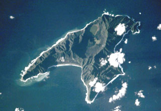
Raoul Island
New Zealand
29.27°S, 177.92°W; summit elev. 516 m
All times are local (unless otherwise noted)
The strongest earthquake swarm since the 1964 eruption began at 0150 on 9 March. About 1 earthquake/minute was felt at the island's meteorological station, ~2 km N of Raoul Caldera and 3 km NW of Denham Bay. The larger events shook trees and caused small rockfalls. There were no apparent changes to the lakes in the caldera or to Denham Bay. On the afternoon of 9 March an overflight revealed no indications of volcanic activity. Though mechanical problems prevented the island's one seismograph from recording any earthquakes until that evening, seven earthquakes were detected in Wellington, ~1,600 km S. The strongest, M 4.3, occurred at 0734. Because the swarm may have been precursory to an eruption, the meteorological station staff of 4 men and 1 dog was evacuated by ship to a location 10 km from the island. They returned the following day and saw that the number of earthquakes had diminished considerably. Earthquakes continued to decline in number and intensity, and on 13 March, the ship departed the island, leaving the staff behind. Analysis of the seismicity indicated the swarm was of tectonic rather than volcanic origin.
No volcanic earthquakes or tremor, such as recorded in the 11 days prior to the 1964 eruption, were detected in this swarm, and the recent earthquakes were fewer and smaller than in 1964. There was no evidence of the increased heat flow to the surface that preceded the 1964 eruption. Though the level of one of the caldera lakes rose 38 cm on 12-25 March, this was minor compared to the rise of 600 cm in 11 days prior to the 1964 eruption.
Geological Summary. Anvil-shaped Raoul Island is the largest and northernmost of the Kermadec Islands. During the past several thousand years volcanism has been dominated by dacitic explosive eruptions. Two Holocene calderas exist, the older of which cuts the center the island and is about 2.5 x 3.5 km wide. Denham caldera, formed during a major dacitic explosive eruption about 2200 years ago, truncated the W side of the island and is 6.5 x 4 km wide. Its long axis is parallel to the tectonic fabric of the Havre Trough that lies W of the volcanic arc. Historical eruptions during the 19th and 20th centuries have sometimes occurred simultaneously from both calderas, and have consisted of small-to-moderate phreatic eruptions, some of which formed ephemeral islands in Denham caldera. An unnamed submarine cone, one of several located along a fissure on the lower NNE flank, has also erupted during historical time, and satellitic vents are concentrated along two parallel NNE-trending lineaments.
Information Contacts: I. Nairn and B. Scott, IGNS Wairakei; J. Latter, IGNS Wellington.