Report on Arenal (Costa Rica) — March 1993

Bulletin of the Global Volcanism Network, vol. 18, no. 3 (March 1993)
Managing Editor: Edward Venzke.
Arenal (Costa Rica) Strombolian activity increases; new lava flow
Please cite this report as:
Global Volcanism Program, 1993. Report on Arenal (Costa Rica) (Venzke, E., ed.). Bulletin of the Global Volcanism Network, 18:3. Smithsonian Institution. https://doi.org/10.5479/si.GVP.BGVN199303-345033
Arenal
Costa Rica
10.463°N, 84.703°W; summit elev. 1670 m
All times are local (unless otherwise noted)
Gas emission and lava flows continued from Crater C. Both the number and magnitude of Strombolian eruptions increased from January and February levels. Some eruptions caused vibration of windows at the Macadamia Biological Observatory (2.7 km S) and ballistic bombs reached the 1,000-m elevation on the flanks.
The more-SW lava flow that was active last month advanced over a grassy field and stopped at 760 m elevation. A new flow descended SW, following the same route as the December 1992 flow. At 1,350 m elevation it divided; one lobe went W, reaching 1,100 m elevation, while the other traveled SW to 1,200 m elevation. Another lava flow moved down the SSW flank to 1,450 m elevation. At 0920 on 31 March, gravitational failure of this flow produced numerous small avalanches falling to 750-850 m elevation. On 23 March at 1930 a pyroclastic flow descended SE to 1,100 m elevation.
Seismic activity remained normal. An average of 40 earthquakes/day were recorded by ICE (figure 53), a slight increase from last month. A seismometer operated by UNA, 2.7 km NE of the main crater, registered a total of 465 explosions and 226.5 hours of tremor during 13-31 March (figure 54. The dominant frequencies of these events were 1.5-2.3 Hz. During 28-30 March the tremor increased, becoming continuous for a 24-hour period. The highest daily total of explosions for the month occurred on 16 March, the fewest on 30 March. Fumaroles near the summit continued to emit sulfur gases and water vapor. Explosions were accompanied by decreased gas emission.
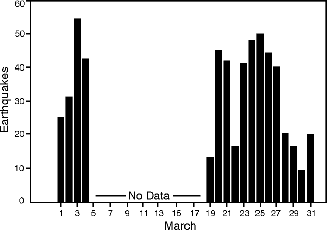 |
Figure 53. Earthquakes/day recorded at Arenal during March 1993. Courtesy of ICE. |
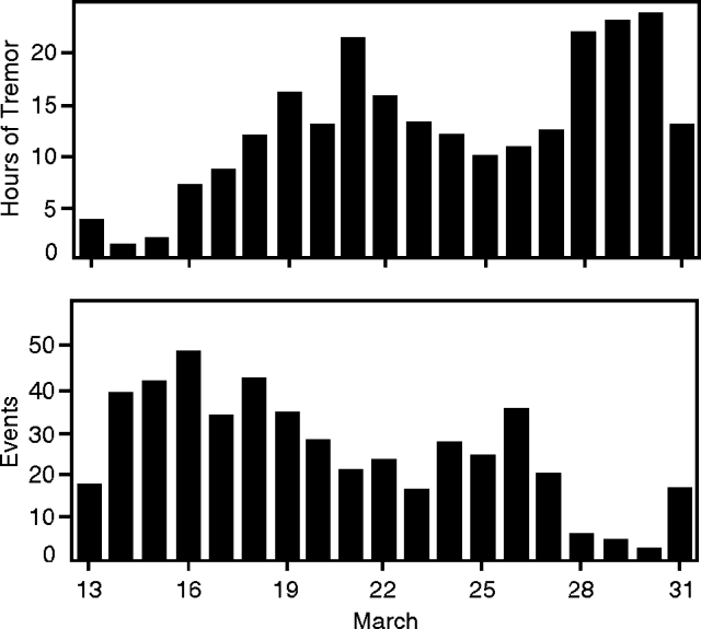 |
Figure 54. Hours of tremor/day (top) and events/day (bottom) recorded 2.7 km NE of the summit of Arenal during 13-31 March 1993. Courtesy of OVSICORI. |
The slight inflationary trend seen at most of the dry-tilt stations stopped. Occasional slight deflation occurred at dry-tilt sites Ferreto (3 km SW of summit) and Cedeño (4 km NW of summit). EDM lines on the S and W contracted in March.
Geological Summary. Conical Volcán Arenal is the youngest stratovolcano in Costa Rica and one of its most active. The 1670-m-high andesitic volcano towers above the eastern shores of Lake Arenal, which has been enlarged by a hydroelectric project. Arenal lies along a volcanic chain that has migrated to the NW from the late-Pleistocene Los Perdidos lava domes through the Pleistocene-to-Holocene Chato volcano, which contains a 500-m-wide, lake-filled summit crater. The earliest known eruptions of Arenal took place about 7000 years ago, and it was active concurrently with Cerro Chato until the activity of Chato ended about 3500 years ago. Growth of Arenal has been characterized by periodic major explosive eruptions at several-hundred-year intervals and periods of lava effusion that armor the cone. An eruptive period that began with a major explosive eruption in 1968 ended in December 2010; continuous explosive activity accompanied by slow lava effusion and the occasional emission of pyroclastic flows characterized the eruption from vents at the summit and on the upper western flank.
Information Contacts: G. Soto and R. Barquero, ICE; E. Fernández, J. Barquero, V. Barboza, T. Marino, R. Van Der Laat, F. de Obaldía, and R. Sáenz, OVSICORI.