Report on Unzendake (Japan) — April 1993

Bulletin of the Global Volcanism Network, vol. 18, no. 4 (April 1993)
Managing Editor: Edward Venzke.
Unzendake (Japan) Pyroclastic flows increase in number; heavy rainfall produces large debris flows
Please cite this report as:
Global Volcanism Program, 1993. Report on Unzendake (Japan) (Venzke, E., ed.). Bulletin of the Global Volcanism Network, 18:4. Smithsonian Institution. https://doi.org/10.5479/si.GVP.BGVN199304-282100
Unzendake
Japan
32.761°N, 130.299°E; summit elev. 1483 m
All times are local (unless otherwise noted)
The swelling of dome 10 and local deformation of the basement rocks N of the dome complex had stopped by mid-April. Large blocks of dome 10 that overhung to the W and N collapsed and scattered around Jigokuato crater, filling it and covering a part of the 1663 lava flow.
Exogenous growth of dome 11 continued. The volume of dome 11 remained constant, implying that the volume of magma supplied to the dome was equal to that lost because of collapses. By mid-May, dome 11 was 150 m long, 150 m wide, and 70 m high.
The seismic network recorded ~ 10 pyroclastic flows/day until 27 April. On 28 and 29 April (both rainy days), 39 and 26 pyroclastic flows were detected, respectively. These were the highest daily totals since 25 September 1992. The monthly total of flows was 352, twice that of March.
The pyroclastic flows, almost all generated by collapses of dome 11, descended mainly E into Mizunashi Valley, NE into Oshiga Valley, and only rarely SE (figure 55). Several flows traveled through Oshiga Valley and entered the Mizunashi River, and some flows entered a headwater of the Nakao River, the upper stream of the Senbongi district. The limit of the flow deposits has been moving slowly N. The longest flow of the month occurred at 1016 on 29 April, traveling 3.5 km E from the dome complex and having a seismic duration of 160 seconds. Ash clouds from the flows rose ~ 1 km above the dome complex, generally higher than those of the past 4 months. The highest cloud rose 1.3 km on 26 April. A pilot reported a very dense, dark-gray column rising to 900 m above the summit and drifting SSE at 1818 on 25 April. The pyroclastic flows caused no damage.
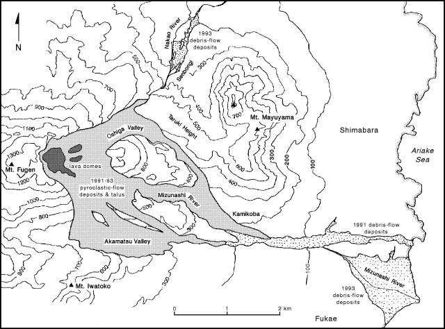 |
Figure 55. Map showing distribution of pyroclastic-flow and debris-flow deposits at Unzen, May 1993. Courtesy of S. Nakada. |
Heavy rainfall on 28-29 April and 2 May generated the largest debris flows of the current eruption, both along the Mizunashi and Nakao rivers. Flows traveled E across highways 57 and 251, and the Shimabara railway, damaging about 500 houses. Prior to the flows, ~ 7,000 people had been asked to evacuate, and no injuries were reported. People were able to return after the rains. The highways were reopened 4 May after the sediment was removed, but the railway remained buried as of mid-May. The Civil Engineer of Nagasaki Prefectural Government estimated the total volume of debris in the Mizunashi River to be > 106 m3.
The number of microearthquakes detected under the dome complex declined . . . to 656 in April. A weak swarm occurred 19-24 April when daily totals increased by a factor of 5. Seismicity near the volcano was low.
The Geographical Survey Institute estimated the total volume of magma erupted from May 1991 to early-March 1993 to be 0.13 km3, and the volume of the dome complex to be 0.05 km3 based on digital mapping data. Over 2,000 residents remain evacuated from Shimabara and Fukae.
Geological Summary. The massive Unzendake volcanic complex comprises much of the Shimabara Peninsula east of the city of Nagasaki. An E-W graben, 30-40 km long, extends across the peninsula. Three large stratovolcanoes with complex structures, Kinugasa on the north, Fugen-dake at the east-center, and Kusenbu on the south, form topographic highs on the broad peninsula. Fugendake and Mayuyama volcanoes in the east-central portion of the andesitic-to-dacitic volcanic complex have been active during the Holocene. The Mayuyama lava dome complex, located along the eastern coast west of Shimabara City, formed about 4000 years ago and was the source of a devastating 1792 CE debris avalanche and tsunami. Historical eruptive activity has been restricted to the summit and flanks of Fugendake. The latest activity during 1990-95 formed a lava dome at the summit, accompanied by pyroclastic flows that caused fatalities and damaged populated areas near Shimabara City.
Information Contacts: JMA; S. Nakada, Kyushu Univ; ICAO.