Report on Colima (Mexico) — August 1993

Bulletin of the Global Volcanism Network, vol. 18, no. 8 (August 1993)
Managing Editor: Edward Venzke.
Colima (Mexico) New 1992 lahar deposit identified, activity declines from last August
Please cite this report as:
Global Volcanism Program, 1993. Report on Colima (Mexico) (Venzke, E., ed.). Bulletin of the Global Volcanism Network, 18:8. Smithsonian Institution. https://doi.org/10.5479/si.GVP.BGVN199308-341040
Colima
Mexico
19.514°N, 103.62°W; summit elev. 3850 m
All times are local (unless otherwise noted)
The following report . . . describes rockfall activity and seismicity between between 1 February and 31 July 1993, the summit area in March 1992 and February 1993, and a 1992 lahar deposit. Frequency of seismic activity, rockfalls, and fumarolic activity are relatively lower than in August 1992. The dome area remains hazardous for all visitors without protective clothing, gas masks, and radio contact.
Seismicity and rockfall activity. High-frequency, low-amplitude seismicity, not clearly distinguished from background levels, was detected from 23 February to 30 March. The signals began intermittently but became constant 28 February-3 March 1993. Twenty-three B-type volcanic earthquakes were recorded during that time period, apparently independent of the high- frequency signals. There were 32 observed rockfalls during this period that were not detected by seismometers.
From April to 31 July 1993, seismic activity was relatively low as 70 B-type events were recorded with no seismically detected rockfalls. Most observed rockfalls were probably associated with small diurnal changes in the hydrothermally altered summit area, which might be related to changes in rock temperature and surface water content. Rockfalls were observed most frequently in April (41), the driest month, followed by May (23), June (15), and July (13).
Observations of the active dome and the summit area. On 8 March 1992, Komorowski, Siebe, and Rodríguez spent 4 hours on and around the active lava dome, where conditions were hot and required gas masks despite the local wind and low air temperature at 3,800 m elevation. Some areas of the lava dome were still too hot to remain on for more than a few seconds. The dome was locally unstable, consisting of a chaotic pile of 2-5 m scoriaceous blocks and dense black lava. Several extrusive "crease structures" (Anderson and Fink, 1992), curviplanar walls of lava, extended from the central valley, resembling the petals of an open flower. The dome had a central depression ~50 m in diameter and 10-20 m deep, which presumably developed after partial deflation between April and December 1991. Dense, scoriaceous lava spines 5 m high rimming the N side of the depression have been present since December 1991. The highest elevation on the dome, excluding the spines, was 3,900 m on 1 December 1991.
A fracture network was identified in the W and NW summit region at about 3,860 m elevation (according to three altimeter readings; 3,810 m on the topographic map). Fractures up to 20 m long trending N75°W to N15°W extended up to the active dome. A normal fault striking N34°W was also observed. Weak fumarolic emissions and sulfur encrustations were seen in the widest (1-2 m), deepest (1 m), and most active fractures. A relatively flat plateau surrounding the active dome on the SW, W, and NW was composed of highly unstable lava and pyroclastic units that have been deeply altered hydrothermally. A 10-m-wide and 1-m-deep circular depression in loose hydrothermally altered material was also seen to the WNW of the active dome at 3,810 m (according to the map). In several areas, ~10-cm-wide fractures had developed and defined highly unstable vertical cliffs several hundred meters above the caldera moat. No rockfalls were observed during this visit, and there were no tremors felt or rumbling sound heard.
Another visit to the summit area and active lava dome was made on 4 February 1993 by Cortés, Navarro, and Komorowski. Variable atmospheric conditions sometimes made it necessary to wear gas masks. The gas plume was very dense in the early morning and filled most of the N and NE Playón area (caldera moat), ~600 m below the summit area. The dome rock was warm in places, and the 1975-76 and 1991 lava flows had weak fumarolic activity, confirming the continued presence of a thermal anomaly. Fumarolic emissions were vigorous but generally unchanged in the area N and NE of the active dome, especially just N of the 1987 phreatic pit.
On 12 February 1993, Navarro and Komorowski made a 35-minute helicopter flight over the summit. No major changes were evident compared with the last overflight by geologists on 20 March 1992. Intense fumarolic emissions were continuing in the pre-1991 lava dome area, N of the present dome. Gas output and plume color were highly variable in this zone. The 1991 lava dome was still weakly degassing, with a grayish to light-brown plume from the central depression. Erosion of unstable, highly altered lava and pyroclastics continued on the SW, N, and W upper summit. Rockfalls and small collapses have been common in this area since the major sequential collapse on 16-17 April 1991 that led to the emplacement of mixed juvenile and accessory pyroclastic flows to the S.
New 1992 lahar deposit identified. Fieldwork in April-May 1993 by Cortés and Navarro revealed the presence of an important lahar deposit in the Montegrande drainage at 1,520-1,900 m elevation, about 7 km S of the summit (figure 18). The lahar traveled 3.6 km to within 4 km NW of the town Quesería (population ~7,735). Above 1,570 m elevation the deposit varies in thickness from 2-4 m and consists of 3-4 sub-units (1.2-1.4 m thick) of semi-consolidated coarse sand to pebble-sized material, separated by thin layers (35 mm) of finer sand. The width of the deposit ranges from 4-7 m. The largest sub-angular boulders (2-3 m) protrude through the flat surface of the deposit and are supported by the finer matrix. In its most distal parts (1,570-1,520 m elevation), the deposit consists of at least three debris fans 60-185 m wide and 50-100 m long. Two farmers who own fields near the lahar deposit indicated that the mass flow occurred after five days of continuous rain in January 1992. About 2 hectares (5 acres) of pasture land and several fruit trees were covered by the lahar deposit, and several bee hives were buried in the river channel.
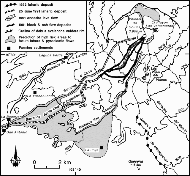 |
Figure 18. Topographic map of the summit area and SW flank of Colima, showing major valleys, recent volcanic deposits, and areas predicted to be at high-risk from future lahars and pyroclastic flows. Modified from Rodríguez-Elizarrarás and others, 1991. |
Based on the fact that the lahar mass-flow deposit is only seen from 1,520-1,900 m elevation (although higher deposits may have been eroded), and given the mean thickness of 3 m and mean channel width of 7 m, the estimated volume of the deposit is 75,600 m3. The volume in the distal debris fans is estimated at about 74,000 m3, giving a total estimated volume of 149,000 m3 compared to the 495,000 m3 of the 25 June 1991 El Cordobán lahar deposit (16:04).
Older lahar deposits have filled the Montegrande drainage and can be observed in the canyon walls. High-voltage electricity towers that bring power to Guadalajara from the Pacific coast have been built on some older lahar deposits in the river channel. Warnings for future lahar flows were given to the authorities of the Colima State Civil Protection, the National Electric Company, and the population of the Quesería area for the June-September 1992 rainy season.
References. Anderson, S.W., and Fink, J.H., 1992, Crease structures: indicators of emplacement rates and surface stress regimes of lava flows: Geological Society of America Bulletin, v. 104, p. 615-625.
Rodríguez-Elizarrarás, S., Siebe, C., Komorowski, J-C., Espíndola, J.M., and Saucedo, R., 1991, Field observations of pristine block-and ash-flow deposits emplaced April 16-17, 1991 at Volcán de Colima, México: Journal of Volcanology and Geothermal Research, v. 48-3/4, p. 399-412.
Geological Summary. The Colima complex is the most prominent volcanic center of the western Mexican Volcanic Belt. It consists of two southward-younging volcanoes, Nevado de Colima (the high point of the complex) on the north and the historically active Volcán de Colima at the south. A group of late-Pleistocene cinder cones is located on the floor of the Colima graben west and east of the complex. Volcán de Colima (also known as Volcán Fuego) is a youthful stratovolcano constructed within a 5-km-wide scarp, breached to the south, that has been the source of large debris avalanches. Major slope failures have occurred repeatedly from both the Nevado and Colima cones, producing thick debris-avalanche deposits on three sides of the complex. Frequent recorded eruptions date back to the 16th century. Occasional major explosive eruptions have destroyed the summit (most recently in 1913) and left a deep, steep-sided crater that was slowly refilled and then overtopped by lava dome growth.
Information Contacts: Carlos Navarro, Abel Cortés, Ignacio Galindo, Ricardo Saucedo, Justo Orozco, and Gabriel Reyes, CUICT, Universidad de Colima; Jean-Christophe Komorowski, Claus Siebe, and Sergio Rodríguez, Instituto de Geofísica, UNAM.