Report on Long Island (Papua New Guinea) — December 1993
Bulletin of the Global Volcanism Network, vol. 18, no. 12 (December 1993)
Managing Editor: Edward Venzke.
Long Island (Papua New Guinea) Eruption ends; details of activity given
Please cite this report as:
Global Volcanism Program, 1993. Report on Long Island (Papua New Guinea) (Venzke, E., ed.). Bulletin of the Global Volcanism Network, 18:12. Smithsonian Institution. https://doi.org/10.5479/si.GVP.BGVN199312-251050
Long Island
Papua New Guinea
5.358°S, 147.12°E; summit elev. 1280 m
All times are local (unless otherwise noted)
"The eruption that began under the caldera lake (figure 1) in early November was effectively over by early December. By late November there was no longer any seismic evidence of eruptive activity. However, mild hydrothermal activity was continuing as indicated by the occasional appearance of patches of discoloured water at the lake surface. The temporary observation post on the NE rim of the caldera was closed on 3 December. There have been no more reports from Long Island, so it is presumed that the eruption is over."
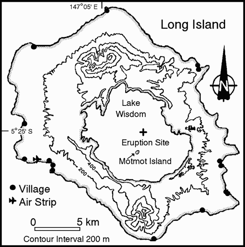 |
Figure 1. Map of Long Island showing the caldera lake (Lake Wisdom), Motmot Island, and the November 1993 eruption site. Courtesy of RVO. |
The following report from RVO provides additional details of the visit . . . on 11 November (BGVN 18:11).
"A temperature survey around Motmot (a cone in the S part of the caldera) revealed that temperatures were much lower than normal; the highest reading was ~45°C. Previously, temperatures at springs and in the beach sand around Motmot were up to ~90°C. It was not possible to carry out a complete temperature survey because of erosion and landslides on the flanks of Motmot and a rise in lake surface level. A GPS survey was also conducted on Motmot, with the survey marks used as photogrammetric targets for the purpose of producing a map of Motmot.
"During an aerial inspection of the caldera lake the source of the eruption was identified. Near the centre of the lake was a fresh sub-circular patch of grey-brown water. The central part of the patch of discoloured water was being frequently disturbed by underwater explosions, and there were several sites of non-explosive upwelling fluids and fine solid particles. The frequent underwater explosions were producing visible shock waves, seen as flashes of white light. The larger explosions broke the lake surface and ejected sprays of water and ash a few tens of metres above the lake surface. The active vents, oriented along an E-W linear vent system that may have been ~500 m long, were located at water depths of 300-350 m.
"A temporary observation post equipped with a portable seismograph was established at the NE rim of the caldera, about 200 m above the lake level, on 13 November. Activity similar to that observed and recorded on 11 November continued until the 16th and then began to decline. After 17 November the explosions were not strong enough to break the surface of the lake, and generated only upwelling cells of fluids and fine solid particles. Audible explosive activity was not detected after 21 November. At the end of November the seismicity was so weak that it could not confidently be distinguished from normal background microseismicity. However, mild underwater activity was continuing as plumes of discoloured water continued to be formed spasmodically. Sometimes the lake had a uniform (normal) blue-green colour.
"The time of commencement of the eruption is not precisely known. However, direct visual observations of water and ash ejections above the lake surface, from a new site remote from Motmot, were made by a local government official on 5 November. These details did not reach the Rabaul Volcano Observatory until 24 November. Another indication of the time of onset of the eruption comes from the seismic records generated at the permanent seismic station at Karkar Island, ~160 km NW of Long Island. Unusual strong, continuous, harmonic tremor, attributed to the eruption at Long Island, began to be recorded at about 1100 on 3 November. It is likely that the sound effects of the underwater explosions alerted the local government official at Long Island to hike in from the coast to the caldera rim to investigate on 5 November.
"The previous eruptive activity at Long Island in the period 1973-75 was centered at Motmot. Short bursts of Strombolian activity erected a number of small spatter and cinder cones, and produced a small lava flow. Temperature surveys indicated minor changes in the plumbing system of springs around Motmot until the mid-1980's. A progressive weakening of thermal activity around Motmot was recorded from late 1985."
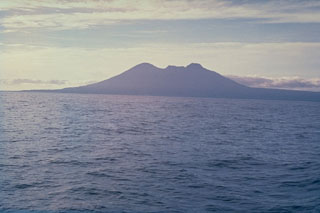
Geological Summary. The broad profile of hexagonal-shaped Long Island is dominated by two steep-sided stratovolcanoes, Mount Reaumur in the north and Cerisy Peak in the south. Collapse of the basaltic-andesitic volcanic complex produced a large 10 x 12.5 km caldera, now filled by Lake Wisdom. Caldera formation occurred during at least three major explosive eruptions, about 16,000, 4000, and 300 years ago. The latter was one of the largest historical eruptions in Papua New Guinea and deposited andesitic tephra across the New Guinea highlands, prompting legends of a "Time of Darkness." Post-caldera eruptions have constructed a small cone, Motmot Island, in the south-central part of Lake Wisdom. Moderate explosive eruptions have occurred during the 20th century from vents at and near Motmot Island.
Information Contacts: C. McKee and R. Stewart, RVO.