Eruption ends; details of activity given
"The eruption that began under the caldera lake (figure 1) in early November was effectively over by early December. By late November there was no longer any seismic evidence of eruptive activity. However, mild hydrothermal activity was continuing as indicated by the occasional appearance of patches of discoloured water at the lake surface. The temporary observation post on the NE rim of the caldera was closed on 3 December. There have been no more reports from Long Island, so it is presumed that the eruption is over."
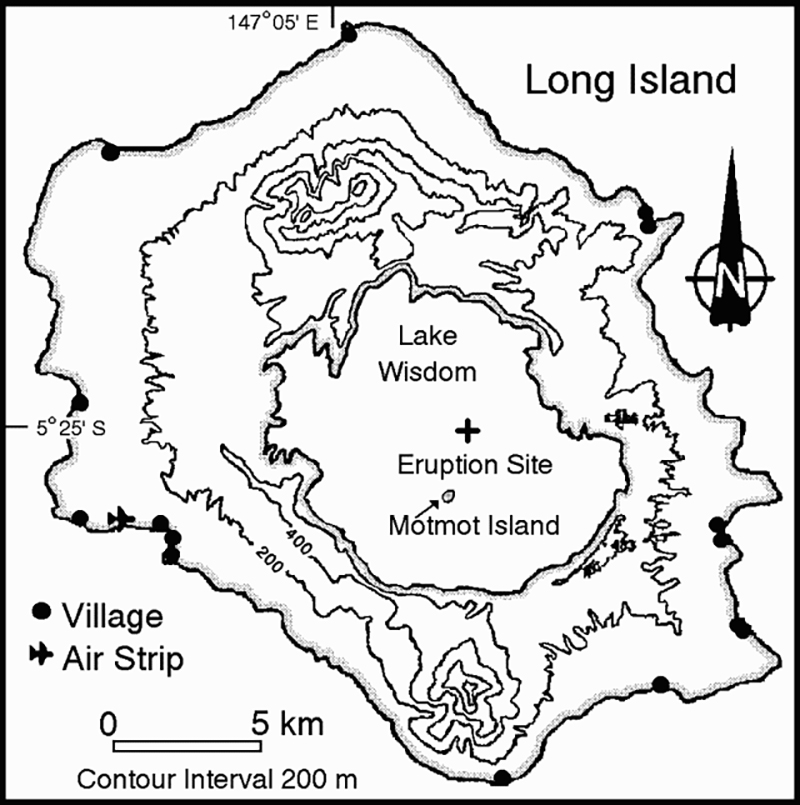 |
Figure 1. Map of Long Island showing the caldera lake (Lake Wisdom), Motmot Island, and the November 1993 eruption site. Courtesy of RVO. |
The following report from RVO provides additional details of the visit . . . on 11 November (BGVN 18:11).
"A temperature survey around Motmot (a cone in the S part of the caldera) revealed that temperatures were much lower than normal; the highest reading was ~45°C. Previously, temperatures at springs and in the beach sand around Motmot were up to ~90°C. It was not possible to carry out a complete temperature survey because of erosion and landslides on the flanks of Motmot and a rise in lake surface level. A GPS survey was also conducted on Motmot, with the survey marks used as photogrammetric targets for the purpose of producing a map of Motmot.
"During an aerial inspection of the caldera lake the source of the eruption was identified. Near the centre of the lake was a fresh sub-circular patch of grey-brown water. The central part of the patch of discoloured water was being frequently disturbed by underwater explosions, and there were several sites of non-explosive upwelling fluids and fine solid particles. The frequent underwater explosions were producing visible shock waves, seen as flashes of white light. The larger explosions broke the lake surface and ejected sprays of water and ash a few tens of metres above the lake surface. The active vents, oriented along an E-W linear vent system that may have been ~500 m long, were located at water depths of 300-350 m.
"A temporary observation post equipped with a portable seismograph was established at the NE rim of the caldera, about 200 m above the lake level, on 13 November. Activity similar to that observed and recorded on 11 November continued until the 16th and then began to decline. After 17 November the explosions were not strong enough to break the surface of the lake, and generated only upwelling cells of fluids and fine solid particles. Audible explosive activity was not detected after 21 November. At the end of November the seismicity was so weak that it could not confidently be distinguished from normal background microseismicity. However, mild underwater activity was continuing as plumes of discoloured water continued to be formed spasmodically. Sometimes the lake had a uniform (normal) blue-green colour.
"The time of commencement of the eruption is not precisely known. However, direct visual observations of water and ash ejections above the lake surface, from a new site remote from Motmot, were made by a local government official on 5 November. These details did not reach the Rabaul Volcano Observatory until 24 November. Another indication of the time of onset of the eruption comes from the seismic records generated at the permanent seismic station at Karkar Island, ~160 km NW of Long Island. Unusual strong, continuous, harmonic tremor, attributed to the eruption at Long Island, began to be recorded at about 1100 on 3 November. It is likely that the sound effects of the underwater explosions alerted the local government official at Long Island to hike in from the coast to the caldera rim to investigate on 5 November.
"The previous eruptive activity at Long Island in the period 1973-75 was centered at Motmot. Short bursts of Strombolian activity erected a number of small spatter and cinder cones, and produced a small lava flow. Temperature surveys indicated minor changes in the plumbing system of springs around Motmot until the mid-1980's. A progressive weakening of thermal activity around Motmot was recorded from late 1985."
Information Contacts: C. McKee and R. Stewart, RVO.
The Global Volcanism Program has no Weekly Reports available for Long Island.
Reports are organized chronologically and indexed below by Month/Year (Publication Volume:Number), and include a one-line summary. Click on the index link or scroll down to read the reports.
Small eruption within the crater lake on 18 April
Card 1626 (08 May 1973) Small eruption within the crater lake on 18 April
The Central Volcanological Observatory reported the following . . . by cable. "A small eruption has occurred on Long Island. The first reports received on 1 May indicate that the eruption started on 18 April. An aerial inspection was made on 2 May and there appears to be no immediate danger to the 700 inhabitants. The eruption center is a small island in the caldera lake ejecting steam and ash at 5-50 second intervals 100-150 m high. Investigations are continuing."
Information Contacts: R.A. Davies, Central Volcanological Observatory, Rabaul, Papua New Guinea.
New fumarolic activity
"A report was received on 26 January of a supposed eruption of Motmot cone about mid-January. A flypast by a volcanologist on 15 January had revealed nothing unusual. However, aerial inspections on 29 January indicated considerable new vapour emission, including one powerful fumarole that was jetting white vapour and possibly water at the W shoreline of Motmot Island (350 m in diameter). Vapour from this jet obscured details nearby, but no clear evidence of recent eruptive activity was noted. No new craters or cones were present, and no new ejecta could be recognised on the island. Pending further information, it is assumed that only vapour activity has occurred so far."
Information Contacts: R. Cooke, RVO.
Fumarolic activity, but no eruption
"An aerial inspection of Long Island on 23 February confirmed that no eruption had taken place in January. Only small volumes of vapour were seen emanating from the summit craters and from a fumarole at the W shoreline. This fumarole is in a different position from the powerful one seen on 29 January."
Information Contacts: C. McKee, RVO.
Low-level activity at thermal areas
"An aerial inspection on 3 September indicated that thermal areas on Motmot . . . remained at a low level of activity. Vegetation was spreading in some areas, notably in the crater of the 1974 cone, and no fresh sulphur deposits were seen.
Information Contacts: I. Itikarai and C. McKee, RVO.
Eruption in early November, first since 1976
"A new eruption began . . . in early November. The first report was received on 8 November but contained few details of activity. A team from RVO overflew Long Island on 9 November and found that almost the entire body of water in the caldera lake (Lake Wisdom) had changed colour, from blue-green to orange-brown, but there was no visible eruptive activity. The source of the discoloured water could not be discerned, although it appeared to be remote from the Motmot cone in the S part of the caldera, the site of the most recent eruptions (mid-1970's). There was no sign of a recent eruption at Motmot itself.
"Volcanologists returned . . . on 11 November to carry out ground-based investigations at Motmot. While setting up a seismograph, frequent earthquakes were felt, and muffled thudding noises were heard. The noises were more noticeable on the N to NE side of Motmot, suggesting that the source of the activity might be offshore in that direction. The seismogram consisted of continuous harmonic and irregular tremor with variable amplitude corresponding with the sound effects."
Information Contacts: I. Itikarai, and C. McKee, RVO.
Eruption ends; details of activity given
"The eruption that began under the caldera lake (figure 1) in early November was effectively over by early December. By late November there was no longer any seismic evidence of eruptive activity. However, mild hydrothermal activity was continuing as indicated by the occasional appearance of patches of discoloured water at the lake surface. The temporary observation post on the NE rim of the caldera was closed on 3 December. There have been no more reports from Long Island, so it is presumed that the eruption is over."
|
Figure 1. Map of Long Island showing the caldera lake (Lake Wisdom), Motmot Island, and the November 1993 eruption site. Courtesy of RVO. |
The following report from RVO provides additional details of the visit . . . on 11 November (BGVN 18:11).
"A temperature survey around Motmot (a cone in the S part of the caldera) revealed that temperatures were much lower than normal; the highest reading was ~45°C. Previously, temperatures at springs and in the beach sand around Motmot were up to ~90°C. It was not possible to carry out a complete temperature survey because of erosion and landslides on the flanks of Motmot and a rise in lake surface level. A GPS survey was also conducted on Motmot, with the survey marks used as photogrammetric targets for the purpose of producing a map of Motmot.
"During an aerial inspection of the caldera lake the source of the eruption was identified. Near the centre of the lake was a fresh sub-circular patch of grey-brown water. The central part of the patch of discoloured water was being frequently disturbed by underwater explosions, and there were several sites of non-explosive upwelling fluids and fine solid particles. The frequent underwater explosions were producing visible shock waves, seen as flashes of white light. The larger explosions broke the lake surface and ejected sprays of water and ash a few tens of metres above the lake surface. The active vents, oriented along an E-W linear vent system that may have been ~500 m long, were located at water depths of 300-350 m.
"A temporary observation post equipped with a portable seismograph was established at the NE rim of the caldera, about 200 m above the lake level, on 13 November. Activity similar to that observed and recorded on 11 November continued until the 16th and then began to decline. After 17 November the explosions were not strong enough to break the surface of the lake, and generated only upwelling cells of fluids and fine solid particles. Audible explosive activity was not detected after 21 November. At the end of November the seismicity was so weak that it could not confidently be distinguished from normal background microseismicity. However, mild underwater activity was continuing as plumes of discoloured water continued to be formed spasmodically. Sometimes the lake had a uniform (normal) blue-green colour.
"The time of commencement of the eruption is not precisely known. However, direct visual observations of water and ash ejections above the lake surface, from a new site remote from Motmot, were made by a local government official on 5 November. These details did not reach the Rabaul Volcano Observatory until 24 November. Another indication of the time of onset of the eruption comes from the seismic records generated at the permanent seismic station at Karkar Island, ~160 km NW of Long Island. Unusual strong, continuous, harmonic tremor, attributed to the eruption at Long Island, began to be recorded at about 1100 on 3 November. It is likely that the sound effects of the underwater explosions alerted the local government official at Long Island to hike in from the coast to the caldera rim to investigate on 5 November.
"The previous eruptive activity at Long Island in the period 1973-75 was centered at Motmot. Short bursts of Strombolian activity erected a number of small spatter and cinder cones, and produced a small lava flow. Temperature surveys indicated minor changes in the plumbing system of springs around Motmot until the mid-1980's. A progressive weakening of thermal activity around Motmot was recorded from late 1985."
Information Contacts: C. McKee and R. Stewart, RVO.
|
|
||||||||||||||||||||||||||
There is data available for 11 confirmed eruptive periods.
1993 Nov 3 (?) - 1993 Nov 25 ± 5 days Confirmed Eruption (Explosive / Effusive) VEI: 1
| Episode 1 | Eruption (Explosive / Effusive) | E-W fissure NNE of Motmot Island | ||||||||||||||||||||||||||||
|---|---|---|---|---|---|---|---|---|---|---|---|---|---|---|---|---|---|---|---|---|---|---|---|---|---|---|---|---|---|
| 1993 Nov 3 (?) - 1993 Nov 25 ± 5 days | Evidence from Observations: Reported | ||||||||||||||||||||||||||||
|
List of 4 Events for Episode 1 at E-W fissure NNE of Motmot Island
|
|||||||||||||||||||||||||||||
1976 Jan 2 ± 120 days Confirmed Eruption (Explosive / Effusive) VEI: 1
| Episode 1 | Eruption (Explosive / Effusive) | Motmot | ||||||||||||||||||
|---|---|---|---|---|---|---|---|---|---|---|---|---|---|---|---|---|---|---|---|
| 1976 Jan 2 ± 120 days - Unknown | Evidence from Observations: Reported | ||||||||||||||||||
|
List of 2 Events for Episode 1 at Motmot
|
|||||||||||||||||||
1973 Apr 16 ± 15 days - 1974 Feb 28 Confirmed Eruption (Explosive / Effusive) VEI: 2
| Episode 1 | Eruption (Explosive / Effusive) | Motmot | |||||||||||||||||||||||||||||||||||||||||||
|---|---|---|---|---|---|---|---|---|---|---|---|---|---|---|---|---|---|---|---|---|---|---|---|---|---|---|---|---|---|---|---|---|---|---|---|---|---|---|---|---|---|---|---|---|
| 1973 Apr 16 ± 15 days - 1974 Feb 28 | Evidence from Observations: Reported | |||||||||||||||||||||||||||||||||||||||||||
|
List of 7 Events for Episode 1 at Motmot
|
||||||||||||||||||||||||||||||||||||||||||||
1968 Mar 16 - 1968 Jun 12 Confirmed Eruption (Explosive / Effusive) VEI: 2
| Episode 1 | Eruption (Explosive / Effusive) | Motmot | |||||||||||||||||||||||||||||||||||||||||||
|---|---|---|---|---|---|---|---|---|---|---|---|---|---|---|---|---|---|---|---|---|---|---|---|---|---|---|---|---|---|---|---|---|---|---|---|---|---|---|---|---|---|---|---|---|
| 1968 Mar 16 - 1968 Jun 12 | Evidence from Observations: Reported | |||||||||||||||||||||||||||||||||||||||||||
|
List of 7 Events for Episode 1 at Motmot
|
||||||||||||||||||||||||||||||||||||||||||||
[ 1961 Jul 2 ± 182 days ] Uncertain Eruption
| Episode 1 | Eruption (Explosive / Effusive) | Motmot | ||||||||||||||||||
|---|---|---|---|---|---|---|---|---|---|---|---|---|---|---|---|---|---|---|---|
| 1961 Jul 2 ± 182 days - Unknown | Evidence from Unknown | ||||||||||||||||||
|
List of 2 Events for Episode 1 at Motmot
|
|||||||||||||||||||
1955 Jun 5 - 1955 Jun 13 Confirmed Eruption (Explosive / Effusive) VEI: 3
| Episode 1 | Eruption (Explosive / Effusive) | Motmot | ||||||||||||||||||||||||||||
|---|---|---|---|---|---|---|---|---|---|---|---|---|---|---|---|---|---|---|---|---|---|---|---|---|---|---|---|---|---|
| 1955 Jun 5 - 1955 Jun 13 | Evidence from Observations: Reported | ||||||||||||||||||||||||||||
|
List of 4 Events for Episode 1 at Motmot
|
|||||||||||||||||||||||||||||
1953 May 8 - 1954 Jan 7 Confirmed Eruption (Explosive / Effusive) VEI: 3
| Episode 1 | Eruption (Explosive / Effusive) | Motmot | ||||||||||||||||||||||||||||||||||||||||||||||||
|---|---|---|---|---|---|---|---|---|---|---|---|---|---|---|---|---|---|---|---|---|---|---|---|---|---|---|---|---|---|---|---|---|---|---|---|---|---|---|---|---|---|---|---|---|---|---|---|---|---|
| 1953 May 8 - 1954 Jan 7 | Evidence from Observations: Reported | ||||||||||||||||||||||||||||||||||||||||||||||||
|
List of 8 Events for Episode 1 at Motmot
|
|||||||||||||||||||||||||||||||||||||||||||||||||
1943 Confirmed Eruption (Explosive / Effusive)
| Episode 1 | Eruption (Explosive / Effusive) | Motmot | |||||||||||||||||||||||
|---|---|---|---|---|---|---|---|---|---|---|---|---|---|---|---|---|---|---|---|---|---|---|---|---|
| 1943 - Unknown | Evidence from Observations: Reported | |||||||||||||||||||||||
|
List of 3 Events for Episode 1 at Motmot
|
||||||||||||||||||||||||
1938 Confirmed Eruption (Explosive / Effusive)
| Episode 1 | Eruption (Explosive / Effusive) | Lake Wisdom | |||
|---|---|---|---|---|
| 1938 - Unknown | Evidence from Observations: Reported | |||
1933 Confirmed Eruption (Explosive / Effusive)
| Episode 1 | Eruption (Explosive / Effusive) | Lake Wisdom | |||
|---|---|---|---|---|
| 1933 - Unknown | Evidence from Observations: Reported | |||
1660 ± 20 years Confirmed Eruption (Explosive / Effusive) VEI: 6
| Episode 1 | Eruption (Explosive / Effusive) | |||||||||||||||||||||||||||||||||||||||||||||||||||||||||||
|---|---|---|---|---|---|---|---|---|---|---|---|---|---|---|---|---|---|---|---|---|---|---|---|---|---|---|---|---|---|---|---|---|---|---|---|---|---|---|---|---|---|---|---|---|---|---|---|---|---|---|---|---|---|---|---|---|---|---|---|
| 1660 ± 20 years - Unknown | Evidence from Isotopic: 14C (uncalibrated) | ||||||||||||||||||||||||||||||||||||||||||||||||||||||||||
| A catastrophic eruption from Long Island deposited tephra across the New Guinea highlands, prompting legends of a "Time of Darkness." Some 14C dates suggest this eruption took place between 1640 and 1680 CE. Large pyroclastic flows from this eruption are thought to be associated with a third phase of caldera collapse at Long Island (Pain et al., 1981). | |||||||||||||||||||||||||||||||||||||||||||||||||||||||||||
|
List of 10 Events for Episode 1
|
|||||||||||||||||||||||||||||||||||||||||||||||||||||||||||
2040 BCE ± 110 years Confirmed Eruption (Explosive / Effusive) VEI: 6
| Episode 1 | Eruption (Explosive / Effusive) | ||||||||||||||||||||||||||||||||||||||||||||
|---|---|---|---|---|---|---|---|---|---|---|---|---|---|---|---|---|---|---|---|---|---|---|---|---|---|---|---|---|---|---|---|---|---|---|---|---|---|---|---|---|---|---|---|---|
| 2040 BCE ± 110 years - Unknown | Evidence from Isotopic: 14C (uncalibrated) | |||||||||||||||||||||||||||||||||||||||||||
| A major tephra eruption and ignimbrite (Bilau beds) 14C dated at 3,990 ± 110 years BP, is thought to be associated with the second episode of caldera collapse at Long Island (Pain et al., 1981). | ||||||||||||||||||||||||||||||||||||||||||||
|
List of 7 Events for Episode 1
|
||||||||||||||||||||||||||||||||||||||||||||
This compilation of synonyms and subsidiary features may not be comprehensive. Features are organized into four major categories: Cones, Craters, Domes, and Thermal Features. Synonyms of features appear indented below the primary name. In some cases additional feature type, elevation, or location details are provided.
Synonyms |
||||
| Arop | Ahrup | ||||
Cones |
||||
| Feature Name | Feature Type | Elevation | Latitude | Longitude |
| Cerisy Peak
Bunaga |
Stratovolcano | 1028 m | 5° 24' 42.00" S | 147° 7' 22.00" E |
| Motmot
Nani |
Cone | 196 m | 5° 21' 8.58" S | 147° 7' 5.53" E |
| North Long Knoll | Cone | -520 m | 5° 5' 16.00" S | 147° 6' 32.00" E |
| Reaumur, Mount
Dowi |
Stratovolcano | 1263 m | 5° 15' 22.55" S | 147° 5' 23.33" E |
| South Long Knoll | Cone | -1021 m | 5° 33' 44.00" S | 147° 4' 17.00" E |
Craters |
||||
| Feature Name | Feature Type | Elevation | Latitude | Longitude |
| Wisdom, Lake | Caldera | 196 m | 5° 20' 14.00" S | 147° 7' 9.00" E |
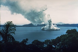 Phreatic explosions from Motmot Island in Lake Wisdom, on Long Island, during a 1953-54 eruption. The Surtseyan explosion produced a jet of steam and ash seen rising above the lake, and a base surge traveling radially away from the vent across the surface. The western wall of the 10 x 12.5 km Long Island caldera is 200-300 m high in the distance. Twentieth century eruptions at Long Island have originated from vents at or near Motmot Island.
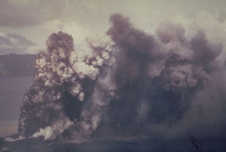 An ash plume rises above Motmot Island within the Lake Wisdom caldera of Long Island in 1953. Explosions that ejected ash and lapilli began on 8 May. Intermittent explosive activity continued until 7 January 1954.
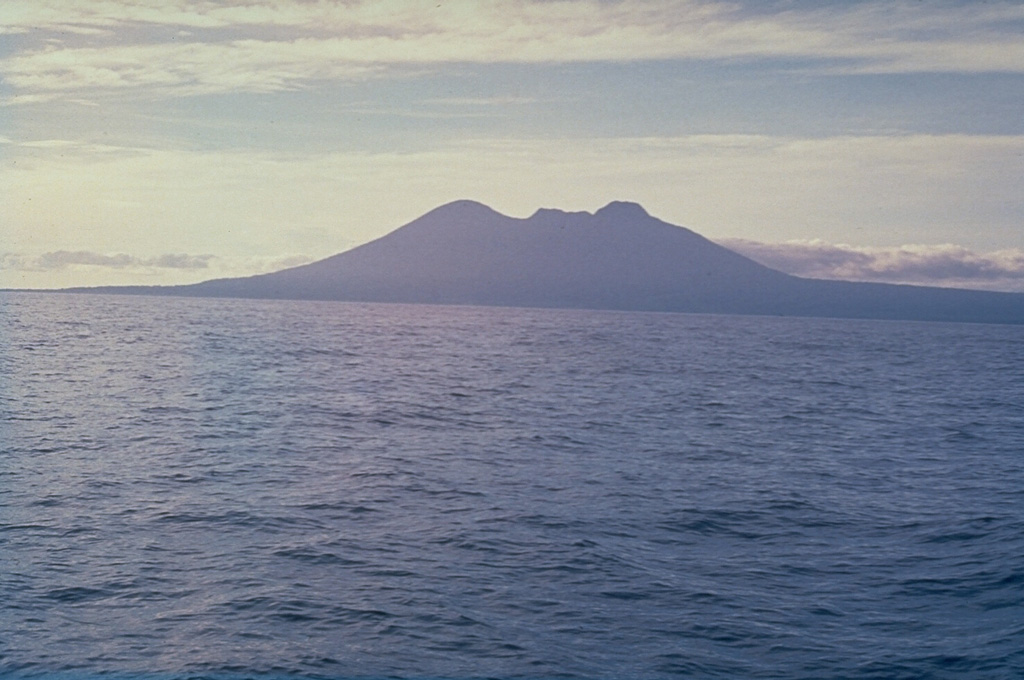
  The broad profile of Long Island, seen here from the E, is composed of two steep-sided edifices, Mount Reaumur to the north (center) and Cerisy Peak to the south. Collapse of the volcanic complex during at least three major explosive eruptions about 16,000, 4,000, and 300 years ago produced a large 10 x 12.5 km caldera, whose low rim appears at the right.
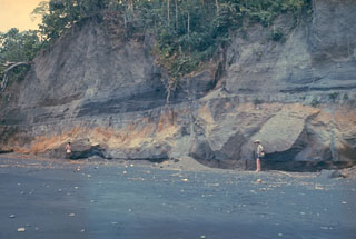 An outcrop on the W coast of Long Island reveals deposits from the last caldera-forming eruption. This catastrophic eruption in the mid-17th century deposited ash across the New Guinea highlands and prompted legends of a "Time of Darkness." This outcrop shows pyroclastic surge and Plinian airfall deposits of the Matapun formation, which is exposed at the top of the section beginning about 4 m above the geologists.
There are no samples for Long Island in the Smithsonian's NMNH Department of Mineral Sciences Rock and Ore collection.
| Copernicus Browser | The Copernicus Browser replaced the Sentinel Hub Playground browser in 2023, to provide access to Earth observation archives from the Copernicus Data Space Ecosystem, the main distribution platform for data from the EU Copernicus missions. |
| MIROVA | Middle InfraRed Observation of Volcanic Activity (MIROVA) is a near real time volcanic hot-spot detection system based on the analysis of MODIS (Moderate Resolution Imaging Spectroradiometer) data. In particular, MIROVA uses the Middle InfraRed Radiation (MIR), measured over target volcanoes, in order to detect, locate and measure the heat radiation sourced from volcanic activity. |
| MODVOLC Thermal Alerts | Using infrared satellite Moderate Resolution Imaging Spectroradiometer (MODIS) data, scientists at the Hawai'i Institute of Geophysics and Planetology, University of Hawai'i, developed an automated system called MODVOLC to map thermal hot-spots in near real time. For each MODIS image, the algorithm automatically scans each 1 km pixel within it to check for high-temperature hot-spots. When one is found the date, time, location, and intensity are recorded. MODIS looks at every square km of the Earth every 48 hours, once during the day and once during the night, and the presence of two MODIS sensors in space allows at least four hot-spot observations every two days. Each day updated global maps are compiled to display the locations of all hot spots detected in the previous 24 hours. There is a drop-down list with volcano names which allow users to 'zoom-in' and examine the distribution of hot-spots at a variety of spatial scales. |
|
WOVOdat
Single Volcano View Temporal Evolution of Unrest Side by Side Volcanoes |
WOVOdat is a database of volcanic unrest; instrumentally and visually recorded changes in seismicity, ground deformation, gas emission, and other parameters from their normal baselines. It is sponsored by the World Organization of Volcano Observatories (WOVO) and presently hosted at the Earth Observatory of Singapore.
GVMID Data on Volcano Monitoring Infrastructure The Global Volcano Monitoring Infrastructure Database GVMID, is aimed at documenting and improving capabilities of volcano monitoring from the ground and space. GVMID should provide a snapshot and baseline view of the techniques and instrumentation that are in place at various volcanoes, which can be use by volcano observatories as reference to setup new monitoring system or improving networks at a specific volcano. These data will allow identification of what monitoring gaps exist, which can be then targeted by remote sensing infrastructure and future instrument deployments. |
| Volcanic Hazard Maps | The IAVCEI Commission on Volcanic Hazards and Risk has a Volcanic Hazard Maps database designed to serve as a resource for hazard mappers (or other interested parties) to explore how common issues in hazard map development have been addressed at different volcanoes, in different countries, for different hazards, and for different intended audiences. In addition to the comprehensive, searchable Volcanic Hazard Maps Database, this website contains information about diversity of volcanic hazard maps, illustrated using examples from the database. This site is for educational purposes related to volcanic hazard maps. Hazard maps found on this website should not be used for emergency purposes. For the most recent, official hazard map for a particular volcano, please seek out the proper institutional authorities on the matter. |
| IRIS seismic stations/networks | Incorporated Research Institutions for Seismology (IRIS) Data Services map showing the location of seismic stations from all available networks (permanent or temporary) within a radius of 0.18° (about 20 km at mid-latitudes) from the given location of Long Island. Users can customize a variety of filters and options in the left panel. Note that if there are no stations are known the map will default to show the entire world with a "No data matched request" error notice. |
| UNAVCO GPS/GNSS stations | Geodetic Data Services map from UNAVCO showing the location of GPS/GNSS stations from all available networks (permanent or temporary) within a radius of 20 km from the given location of Long Island. Users can customize the data search based on station or network names, location, and time window. Requires Adobe Flash Player. |
| DECADE Data | The DECADE portal, still in the developmental stage, serves as an example of the proposed interoperability between The Smithsonian Institution's Global Volcanism Program, the Mapping Gas Emissions (MaGa) Database, and the EarthChem Geochemical Portal. The Deep Earth Carbon Degassing (DECADE) initiative seeks to use new and established technologies to determine accurate global fluxes of volcanic CO2 to the atmosphere, but installing CO2 monitoring networks on 20 of the world's 150 most actively degassing volcanoes. The group uses related laboratory-based studies (direct gas sampling and analysis, melt inclusions) to provide new data for direct degassing of deep earth carbon to the atmosphere. |
| Large Eruptions of Long Island | Information about large Quaternary eruptions (VEI >= 4) is cataloged in the Large Magnitude Explosive Volcanic Eruptions (LaMEVE) database of the Volcano Global Risk Identification and Analysis Project (VOGRIPA). |
| EarthChem | EarthChem develops and maintains databases, software, and services that support the preservation, discovery, access and analysis of geochemical data, and facilitate their integration with the broad array of other available earth science parameters. EarthChem is operated by a joint team of disciplinary scientists, data scientists, data managers and information technology developers who are part of the NSF-funded data facility Integrated Earth Data Applications (IEDA). IEDA is a collaborative effort of EarthChem and the Marine Geoscience Data System (MGDS). |

