Report on Colima (Mexico) — March 1994

Bulletin of the Global Volcanism Network, vol. 19, no. 3 (March 1994)
Managing Editor: Richard Wunderman.
Colima (Mexico) Fresh lava on the active dome; no subsidence in the past year
Please cite this report as:
Global Volcanism Program, 1994. Report on Colima (Mexico) (Wunderman, R., ed.). Bulletin of the Global Volcanism Network, 19:3. Smithsonian Institution. https://doi.org/10.5479/si.GVP.BGVN199403-341040
Colima
Mexico
19.514°N, 103.62°W; summit elev. 3850 m
All times are local (unless otherwise noted)
Clouds hampered observations during a climb to the summit on 2 March. Fresh, dark, unaltered lava on the active dome (figure 19) was hot, particularly along cracks. [J.B. Murray clarifies that this visual description was meant to emphasize the contrast between the newer dome rocks, which remained hot, and older highly altered rocks elsewhere. There was no evidence on 2 March to suggest that new lava had extruded since 1992.] The well-defined dome, ~100 m across and 15 m above the general level of the summit, had a depression on the W side. Fumarolic activity was concentrated in a pit on the E edge of the summit.
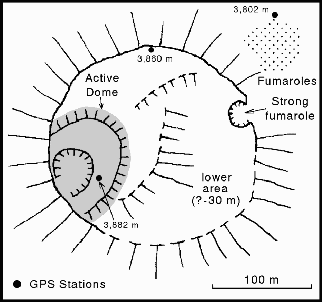 |
Figure 19. Sketch map of the summit area of Colima, 2 March 1994, showing the active dome, fumarole locations, and elevations of GPS stations. Courtesy of J. Murray and B. van Wyk de Vries. |
Only one rockfall was observed every 6 hours, compared to an average of one every 47 minutes recorded by John Murray during visits between 1982 and 1993. The low rockfall activity has coincided with an apparent change in the deformation regime. Preliminary analysis of 26 February-4 March 1994 ground deformation data, compared to the February 1993 survey, revealed no definite subsidence (unlike previous years), little movement, and no vertical changes >1 cm. Some stations have subsided while others have risen during this period.
Three GPS stations were established in the summit area: 1) at 3,802 m near the lowest fumarole on the NE side, 2) at 3,860 m near the N edge of the summit plateau, and 3) on the active dome. The station on the active dome was close to the summit, presently one of 4-5 lava spires protruding from the top of the dome at a measured elevation of 3,882 m (19.512°N, 103.617°W). These elevations are relative to the stations on the leveling traverse only; the nearest benchmarks of the national network are >20 km away. Elevations of the leveling stations were estimated by interpolation relative to the contours on 1:50,000 maps, and are consistent with accurately leveled heights to ± 3.4 m standard deviation. The summit height on the map is between 3,820 and 3,840 m. Although this implies an increase of >40 m since the aerial survey in 1975, the accuracy of the map is unknown.
Geological Summary. The Colima complex is the most prominent volcanic center of the western Mexican Volcanic Belt. It consists of two southward-younging volcanoes, Nevado de Colima (the high point of the complex) on the north and the historically active Volcán de Colima at the south. A group of late-Pleistocene cinder cones is located on the floor of the Colima graben west and east of the complex. Volcán de Colima (also known as Volcán Fuego) is a youthful stratovolcano constructed within a 5-km-wide scarp, breached to the south, that has been the source of large debris avalanches. Major slope failures have occurred repeatedly from both the Nevado and Colima cones, producing thick debris-avalanche deposits on three sides of the complex. Frequent recorded eruptions date back to the 16th century. Occasional major explosive eruptions have destroyed the summit (most recently in 1913) and left a deep, steep-sided crater that was slowly refilled and then overtopped by lava dome growth.
Information Contacts: J. Murray and B. van Wyk de Vries, Open Univ; Mitchell Ventura and Julian H. Reynoso, Colima Fire Service, Colima, México.