Report on Merapi (Indonesia) — July 1994

Bulletin of the Global Volcanism Network, vol. 19, no. 7 (July 1994)
Managing Editor: Richard Wunderman.
Merapi (Indonesia) Increased deformation precedes a nuee ardente
Please cite this report as:
Global Volcanism Program, 1994. Report on Merapi (Indonesia) (Wunderman, R., ed.). Bulletin of the Global Volcanism Network, 19:7. Smithsonian Institution. https://doi.org/10.5479/si.GVP.BGVN199407-263250
Merapi
Indonesia
7.54°S, 110.446°E; summit elev. 2910 m
All times are local (unless otherwise noted)
A nuée ardente erupted around 1400 on 16 July 1994, an event preceded by a clear increase in tilt several days before the eruption. Figure 9 shows tilt measurements during the interval 1-18 July. One set of measurements came from a site on Merapi's summit (Goa Jepang, ~2,900 m elevation); the other set of measurements came from a cave on Merapi's S flank (~1,000 m elevation).
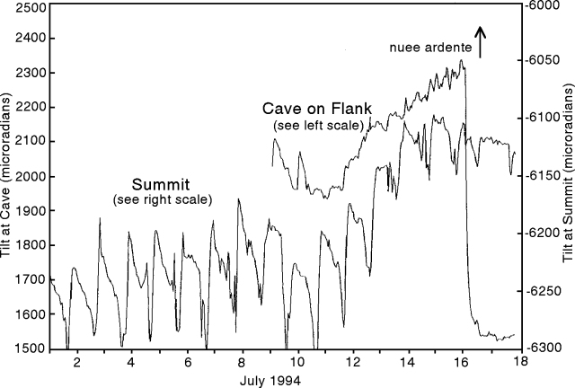 |
Figure 9. Tilt at Merapi recorded at both the summit and in a cave on the S flank, 1-18 July 1994 Courtesy of Arnold Brodscholl. |
The daily temperature variation in the cave is<1°C, suggesting little influence from temperature there (left-hand scale). The daily record of tilt varied significantly less at the cave site (typically <100 µrad) than at the summit site (typically ~150 µrad), an observation consistent with the more stable temperature in the cave.
Tilt began increasing at both sites roughly five days prior to the eruption. During this interval the tilt at both sites correlated consistently overall, and moderately at the finer-scale. Tilt ceased to track consistently near the end of the eruption, when the flank site underwent a dramatic decrease, a turn-around that began prior to the end of the eruption. Summit tilt measurements in January 1993 were similar to those presented here but then measurements at the cave site were a rarity, leaving the increased tilt without confirmation.
Geological Summary. Merapi, one of Indonesia's most active volcanoes, lies in one of the world's most densely populated areas and dominates the landscape immediately north of the major city of Yogyakarta. It is the youngest and southernmost of a volcanic chain extending NNW to Ungaran volcano. Growth of Old Merapi during the Pleistocene ended with major edifice collapse perhaps about 2,000 years ago, leaving a large arcuate scarp cutting the eroded older Batulawang volcano. Subsequent growth of the steep-sided Young Merapi edifice, its upper part unvegetated due to frequent activity, began SW of the earlier collapse scarp. Pyroclastic flows and lahars accompanying growth and collapse of the steep-sided active summit lava dome have devastated cultivated lands on the western-to-southern flanks and caused many fatalities.
Information Contacts: A. Brodscholl, GMU; Subandryo, VSI; B. Voight, Pennsylvania State Univ.