Report on Colima (Mexico) — August 1994

Bulletin of the Global Volcanism Network, vol. 19, no. 8 (August 1994)
Managing Editor: Richard Wunderman.
Colima (Mexico) Additional details about 21 July explosion; recent deposits described
Please cite this report as:
Global Volcanism Program, 1994. Report on Colima (Mexico) (Wunderman, R., ed.). Bulletin of the Global Volcanism Network, 19:8. Smithsonian Institution. https://doi.org/10.5479/si.GVP.BGVN199408-341040
Colima
Mexico
19.514°N, 103.62°W; summit elev. 3850 m
All times are local (unless otherwise noted)
Increased seismicity in July 1994 culminated in a phreatic explosion on 21 July, destroying the 1991 lobe and producing avalanches and ashfall. The following report, from the geology group of the CUICT at the Universidad de Colima, provides additional details about this activity based on observations from La Yerbabuena village (8 km SW of Colima).
Rock avalanches occurred during the two days prior to the explosion at 2020 on 21 July. At La Yerbabuena it was possible to hear about 15 rock avalanches between 2230 and 2330 on 19 July, each lasting for 2-3 minutes. The day before the explosion, 11 rock avalanches with durations of 1-3 minutes were heard within 3.5 hours, but rain and fog hindered observations. On 21 July, two eyewitnesses, located 10 km (rancho El Jabalí) and 8.5 km (rancho La Joya) SSW of the volcano, respectively (figure 20), observed 30 minutes of incandescent rock avalanches down the SW flank just prior to the explosion. Following these avalanches there was a 15-second-long sharp hissing sound, a reddish glow at the summit, and then the explosion. A dark mushroom-shaped column rose above the summit and remained for about 15 minutes before dissipating. The explosion was heard within a radius of 20-35 km S of the volcano (figure 20). Rock avalanches continued throughout the rest of the night.
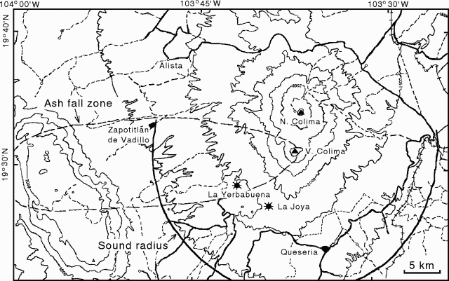 |
Figure 20. Map of the area around Colima volcano showing the limit of ashfall (dashed line) from the 21 July 1994 phreatic explosion, and the radius within which the explosion was heard (heavy line). Courtesy of Geology group at CUICT. |
Light ashfall began 30 minutes after the explosion and lasted for 90 minutes. An accumulation of 36.6 g of ash was measured during the first hour within a 1 m2 area at La Yerbabuena. Observations of the ash that night using a binocular microscope revealed no juvenile glass. Winds with velocities of 7.5-11.8 m/s at 3,500 m altitude transported ash as far as 35 km W, forming a deposit2 (figure 20). The ashfall caused no adverse effects to people or vegetation because of rainfall during the next few days.
Block-and-ash flows left deposits in the upper part of El Cordobán valley that stopped at 2,700 and 2,325 m elevation in two branches of the valley. Because of these deposits, civil protection authorities were notified of the possibility of lahars farther down the valleys during the current rainy season, similar to those that occurred following the 1991 eruption. Six days after deposition, temperatures at 20 cm depth in pristine block-and-ash-flow deposits were 116-282°C; some blocks yeilded temperatures of 120°C. Gas pipe structures were identified where hot vapor was escaping and forming conical features on the surface of the deposit. The block-and-ash-flow deposits had an average thickness of ~4 m and an estimated total volume of 450,000 m3 (in both branches). A massive ash-cloud surge deposit found on both sides of the El Cordobán valley was 1-2 cm thick and 50-70 m wide; brushwood and small trees were inclined in the direction of the flow, and maguey plants close to the valley rim were scorched. The ash-cloud surge extended ~500 m beyond the block-and-ash flow, and covered surrounding vegetation with 1-3 cm of ash.
A new lahar deposit was discovered at 1,650 m elevation in the Cordobán Valley. It was 80 cm thick and had enlarged the width of the channel by 1.7 m. Two eyewitnesses confirmed that at 1700 on 25 August, following three hours of rainfall, a lahar descended with the sound of rolling rocks. The lahar traveled ~10 km downslope, and covered part of a road at about 1,250 m elevation.
COSPEC flights made on 25 July and 6 August revealed an SO2 flux of 270 metric tons/day, close to the baseline value of 300 tons/day. Seismicity recorded at the Red Sísmica de Colima (RESCO) was low for the first 48 hours after the 21 July explosion, but then increased above the level recorded in the 72 hours before the explosion. A few minor explosions were also detected seismically.
Geological Summary. The Colima complex is the most prominent volcanic center of the western Mexican Volcanic Belt. It consists of two southward-younging volcanoes, Nevado de Colima (the high point of the complex) on the north and the historically active Volcán de Colima at the south. A group of late-Pleistocene cinder cones is located on the floor of the Colima graben west and east of the complex. Volcán de Colima (also known as Volcán Fuego) is a youthful stratovolcano constructed within a 5-km-wide scarp, breached to the south, that has been the source of large debris avalanches. Major slope failures have occurred repeatedly from both the Nevado and Colima cones, producing thick debris-avalanche deposits on three sides of the complex. Frequent recorded eruptions date back to the 16th century. Occasional major explosive eruptions have destroyed the summit (most recently in 1913) and left a deep, steep-sided crater that was slowly refilled and then overtopped by lava dome growth.
Information Contacts: C. Navarro, A. Cortés, R. Saucedo, J-C. Gavilanes, J. Orozco, A. González, and I. Galindo (Director), CUICT-Universidad de Colima; G. Reyes and A. Ramírez, Centro de Investigación en Ciencias Básicas (RESCO-CICBAS), Universidad de Colima.