Report on Unzendake (Japan) — December 1994

Bulletin of the Global Volcanism Network, vol. 19, no. 12 (December 1994)
Managing Editor: Richard Wunderman.
Unzendake (Japan) Endogenous dome growth increases summit to 1,500 m
Please cite this report as:
Global Volcanism Program, 1994. Report on Unzendake (Japan) (Wunderman, R., ed.). Bulletin of the Global Volcanism Network, 19:12. Smithsonian Institution. https://doi.org/10.5479/si.GVP.BGVN199412-282100
Unzendake
Japan
32.761°N, 130.299°E; summit elev. 1483 m
All times are local (unless otherwise noted)
Theodolite crest-line measurements from the UWS revealed continued steady endogenous growth of the center of the dome up towards the W at a rate of ~0.7 m/day. The elongated lava-block spine reached 1,500 m elevation in early January 1995 (figure 77). [This is ~140 m higher than the summit of Fugen-dake, previously the highest peak of the Unzen volcanic complex.] Thickness of the dome above the original crater floor increased to 250 m. Three periods of vertical growth have taken place during this endogenous event that started in the end of 1993: January-March 1994, June-July, and November-January 1995. After each uplift event, a new part of the dome increased in height while the old peak subsided.
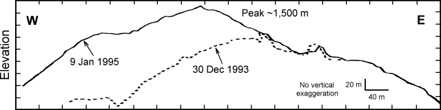 |
Figure 77. Profile of the Unzen lava dome, 30 December 1993 and 9 January 1995, determined by theodolite measurements from ~2 km SSW. Courtesy of JMA. |
Microearthquakes beneath the lava dome totaled 329 in December (less than 35/day) at a seismic station ~3.6 km SW of the dome (table 15). The number of daily events beneath the dome varied, but generally decreased in early 1995. For the first time since 5 January 1994, an earthquake beneath the dome on 28 December was felt at the UWS. Collapse of the lava dome caused 12 pyroclastic flows in December that went NE and SE; the longest traveled 2 km SE.
Table 15. Monthly number of seismic events at Unzen, 1994. Monthly totals for 1991-92 can be found in 17:12, and for 1993 in 19:6. Courtesy of JMA.
| Year/Month | Earthquakes | Pyroclastic Flows |
| 1990 | 4,018 | -- |
| 1991 | 19,101 | 2,756 |
| 1992 | 53,400 | 3,918 |
| 1993 | 54,987 | 1,951 |
| 1994 | 34,566 | 782 |
| Jan 1994 | 1,863 | 75 |
| Feb 1994 | 1,725 | 80 |
| Mar 1994 | 5,110 | 10 |
| Apr 1994 | 4,606 | 16 |
| May 1994 | 3,171 | 33 |
| Jun 1994 | 3,279 | 105 |
| Jul 1994 | 2,488 | 44 |
| Aug 1994 | 7,306 | 264 |
| Sep 1994 | 3,260 | 128 |
| Oct 1994 | 993 | 7 |
| Nov 1994 | 436 | 8 |
| Dec 1994 | 329 | 12 |
Geological Summary. The massive Unzendake volcanic complex comprises much of the Shimabara Peninsula east of the city of Nagasaki. An E-W graben, 30-40 km long, extends across the peninsula. Three large stratovolcanoes with complex structures, Kinugasa on the north, Fugen-dake at the east-center, and Kusenbu on the south, form topographic highs on the broad peninsula. Fugendake and Mayuyama volcanoes in the east-central portion of the andesitic-to-dacitic volcanic complex have been active during the Holocene. The Mayuyama lava dome complex, located along the eastern coast west of Shimabara City, formed about 4000 years ago and was the source of a devastating 1792 CE debris avalanche and tsunami. Historical eruptive activity has been restricted to the summit and flanks of Fugendake. The latest activity during 1990-95 formed a lava dome at the summit, accompanied by pyroclastic flows that caused fatalities and damaged populated areas near Shimabara City.
Information Contacts: S. Nakada, Univ of Tokyo; JMA.