Report on Colima (Mexico) — February 1995

Bulletin of the Global Volcanism Network, vol. 20, no. 2 (February 1995)
Managing Editor: Richard Wunderman.
Colima (Mexico) Summit temperatures, gas measurements, and July 1994 explosion crater description
Please cite this report as:
Global Volcanism Program, 1995. Report on Colima (Mexico) (Wunderman, R., ed.). Bulletin of the Global Volcanism Network, 20:2. Smithsonian Institution. https://doi.org/10.5479/si.GVP.BGVN199502-341040
Colima
Mexico
19.514°N, 103.62°W; summit elev. 3850 m
All times are local (unless otherwise noted)
Scientists from the geologic group of CUICT (Centro Universitario de Investigaciones en Ciencias de la Tierra), RESCO (Red Sismologica Telemetrica de Colima), and the Colima Volcano Observatory at the University of Colima visited the summit on 4 and 15 February 1995.
During a previous ascent on 20 May 1994, temperature measurements of fumaroles were taken at 21 locations in two areas, E and NE of the summit; values were in the 274-304°C range. A gas sampling experiment (SO2 and CO2) used an aspirating pump (Matheson-Kitagawa toxic gas detector system) with 100-ml precision detector tubes and 1-5 minute collection times. SO2 values of 200 ppm were measured at both sites; CO2was 0.2 and 0.3%, respectively. Low temperatures (<60°C) at the gas sampling sites were required. A second ascent later in 1994 was not undertaken because of increased seismicity following a phreatic explosion in July.
During February 1995, the group visited the same points as in May 1994, as well as the bottom of the July 1994 crater. On 4 February, fumarole temperatures measured at 17 locations in the E summit area averaged 372°C, with a high value of 504°C. Temperatures in the NE sector averaged 398°C. Gas sampling (HF, HCl, SO2, and CO2) was again conducted at almost the same sites. Values in the E and NE sectors, respectively, were as follows for each gas: HF, 17.4 and 78.3 ppm; HCl, 8.0 and 63.3 ppm; SO2, 180 and 460 ppm; CO2, 0.25 and 0.85%. On 15 February, temperatures taken inside the E rim of the July 1994 crater averaged 230°C. A survey showed the crater to have a rim diameter of 135 m, a depth of 40 m, a floor diameter of 37 m, and an internal slope of 30° on the E side (figure 21).
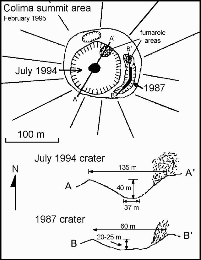 |
Figure 21. Sketch map and topographic profiles of the summit of Colima, February 1995. Courtesy of Andrea Csillag Tirelli, Universidad de Colima. |
A flight was made during clear weather on 11 February with a correlation spectrometer (COSPEC) to measure the SO2 flux. Ten traverses at 3,050 m altitude were made between two navigational benchmarks using the aircraft global positioning system (GPS), assuming that the traverses were perpendicular to the plume axis. Wind speed and direction was computed using GPS at two points beneath the plume as well as before and after the traverses above the summit. Wind direction was 289° with an average velocity of 10.9 m/s. The SO2 flux was determined to be 386 ± 160 metric tons/day, and was calculated according to instructions provided by S. Williams during a June 1994 workshop at UNAM in México City.
Geological Summary. The Colima complex is the most prominent volcanic center of the western Mexican Volcanic Belt. It consists of two southward-younging volcanoes, Nevado de Colima (the high point of the complex) on the north and the historically active Volcán de Colima at the south. A group of late-Pleistocene cinder cones is located on the floor of the Colima graben west and east of the complex. Volcán de Colima (also known as Volcán Fuego) is a youthful stratovolcano constructed within a 5-km-wide scarp, breached to the south, that has been the source of large debris avalanches. Major slope failures have occurred repeatedly from both the Nevado and Colima cones, producing thick debris-avalanche deposits on three sides of the complex. Frequent recorded eruptions date back to the 16th century. Occasional major explosive eruptions have destroyed the summit (most recently in 1913) and left a deep, steep-sided crater that was slowly refilled and then overtopped by lava dome growth.
Information Contacts: Carlos Navarro, Juan-José Ramirez, Abel Cortes, and Juan-Carlos Gavilanes, Colima Volcano Observatory and CUICT, Universidad de Colima; Andrea Csillag Tirelli, RESCO-CICBAS, Universidad de Colima.