Report on Colima (Mexico) — June 1995

Bulletin of the Global Volcanism Network, vol. 20, no. 6 (June 1995)
Managing Editor: Richard Wunderman.
Colima (Mexico) SO2 flux comparisons, fumarole temperatures, and impact crater measurements
Please cite this report as:
Global Volcanism Program, 1995. Report on Colima (Mexico) (Wunderman, R., ed.). Bulletin of the Global Volcanism Network, 20:6. Smithsonian Institution. https://doi.org/10.5479/si.GVP.BGVN199506-341040
Colima
Mexico
19.514°N, 103.62°W; summit elev. 3850 m
All times are local (unless otherwise noted)
The following report concerns the SO2 flux in the last half of 1994 and early 1995, and field measurements of fumarole temperatures along with the sizes of impact craters and the projectiles that formed them during the 21 July 1994 ballistic shower.
COSPEC SO2 measurements. . . . on 18 March 1995, our group, consisting of J-J. Ramirez Ruiz, J-C. Gavilanes, A. Cortes, C. Navarro Ochoa, and J-C. Komorowski, flew seven transects at 2,590 m altitude, below the plume, in cloudless weather. The roughly 8-km-long traverses always began and ended over the same navigational benchmarks, which were found using the aircraft's global positioning system (GPS). The speed and direction of the wind was computed at the beginning and end of each traverse. Before the first, and after the last transect we flew at the elevation of the plume (3,352 m) and along the plume's long axis to take wind velocity measurements at varying distances from the summit. Wind speed averaged 4.9 m/s at a bearing of 330°. The SO2 flux calculated as detailed in Casadevall and others (1994), was 69 ± 32 metric tons/day (t/d) with a range of 50-100 t/d.
These values were confirmed by vehicle-based terrestrial measurements of SO2, carried out two hours after the flight. The vehicle traversed below the plume at an elevation of ~1,000 m along the Colima-Guadalajara highway, 16 km E of the volcano summit. Five 13-km-long transects were made perpendicular to the plume direction. For these measurements we arrived at the relevant average wind speed of 3.5 m/s based on observations at the Volcancito meteorological station (located 1 km NE of the volcano at 3,550 m elevation). The resulting SO2 flux measurements gave an average value of 92 ± 24 t/d with a range of 68-111. These mobile terrestrial measurements, the first reported for Colima, were in good agreement with the above-stated airborne ones.
A summary of some Colima SO2 flux measurements appears in table 1. The 29 November flux is previously unreported CUICT data. The 11 February 1995 flux was corrected by CUICT scientists from the 386 ± 160 t/d reported in BGVN 20:02. The lowest measured SO2fluxes at Colima are for the 1986 period,
Table 1. Colima SO2 flux values in the second half of 1994 and early 1995. Sulfur dioxide was "almost undetectable" on 16 July prior to the 21 July 1994 eruption. Courtesy of CUICT.
| Date | SO2 flux (t/d) |
| 25 Jul 1994 | 256 |
| 25 Jul (puff) | 458 |
| 23 Nov 1994 | 79 |
| 29 Nov 1994 | 109 |
| 11 Feb 1995 | 77 ± 32 |
| 18 Mar 1995 | 69 ± 32 |
Field Observations. On 24 March 1995 our group (listed above) and R. Saucedo climbed to the summit for the monthly fumarole temperature monitoring and for visual observations of the 21 July 1994 explosion crater (figures 22 and 23). We spent about two hours at the summit, including an hour within the July 1994 crater. During our summit visit no earthquakes were felt and no rockfalls were heard or seen from the upper parts of the edifice. In contrast, during fieldwork around the volcano before and after the summit visit (14-27 March), we saw several rockfalls and associated dust clouds, including some viewed from as far as ~20 km away (Comala). The falls came mainly from the region S and W of the upper summit, oversteepened areas with high hydrothermal alteration.
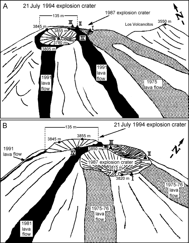 |
Figure 22. Sketch of the present Colima summit area with main topographic and geologic features and location of stable monitored fumarole areas. Elevations obtained from hand-held altimeter readings are relative, but appear comparable to those given by Murray and van Wyk de Vries in 1994 based on GPS and leveling data (BGVN 19:03). Redrawn after photos taken by Abel Cortes, CUICT, on 8 April 1995. |
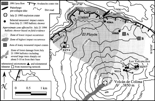 |
Figure 23. Map of the Colima area, showing part of the flat to gently sloping Playon area, situated between the active cone of Volcan de Fuego and the older Paleofuego volcano caldera wall. The map shows the area affected by the 21 July 1994 ballistic shower. Many of the impact craters measured were located in Areas A and B (each of these areas is 100 x 100 m in size). Courtesy of CUIT and J-C. Komorowski. |
Fumarolic emissions seemed unchanged overall and temperatures were similar to February 1995. Fumaroles remained vigorous N and NE of the July 1994 explosion crater, especially just N of the 1987 explosion crater. The E-rim fumarole (Connor's area, shown as fumarole I, figure 22) had an average temperature of 381.5°C and a maximum of 503.2°C. Gas masks were needed to work in some areas, including the N-NE strong fumarolic emission zone (areas I, II, and III on figure 22), the 1987 explosion crater, and inside and on the SE rim of the July 1994 crater.
The NE fumarole was the most vigorous of the summit areas (fumarole II, figure 22; same area labeled as "strong fumarole" by Murray and van Wyk de Vries in their summit sketch map in BGVN 19:03) with an average temperature of 359.2°C and a maximum of 420.2°C.
Overall, the main stable fumarole areas have shown the following temperature ranges over the last few months of monitoring by Colima CUICT scientists: fumarole I (167-504°C), fumarole II (312-490°C), fumarole III (306-488°C), and fumarole IV (210-265°C).
The summit appeared morphologically similar to when last visited on 4 and 15 February 1995 (BGVN 20:02). An area of meter-sized blocks with a peculiar jigsaw-fit pattern, repeatedly monitored for new movements within the crater, also showed no changes. The crater walls consisted of a chaotic pile of rubble blocks typically decimeters in size, and locally oxidized to reddish and yellowish colors.
A general impression was that numerous zones of yellowish sulfur had precipitated since February on the inner walls of the July 1994 crater. Sulfur crusts formed streaks extending primarily from the interior of the 21 July explosion crater, trending towards the NE and E sides of the rim and coinciding with a fracture/dike system (oriented N76E and inclined 12°E within the crater wall). Several fumaroles were located part way up the slope inside the crater, however, this crater displayed strikingly little fumarolic activity (during the dry season) compared to the area N of the 1987 explosion crater.
The majority of impact craters seen in the El Playon area and on the narrow pass between Colima volcano and Los Volcancitos were produced by blocks of dense gray vitreous fresh-looking lava identical to that found in small, 10-m2 patches on the explosion crater's walls. Thus, the explosion exhumed pre-1991 dome lavas. The degree of alteration and stratigraphic position of the dome lavas indicated they were not the result of a minor post-explosion extrusive event. In addition, we interpreted the July 1994 explosion, which took place in the rainy season, to have occurred at the buried base of the 1991 dome and its roots. The eruption probably occurred as a result of accumulation of magmatic and hydrothermally derived gases.
Five days prior to the 21 July 1994 eruption, the SO2 flux had reached so low as to be "almost undetectable" but on 25 July it rose to a mean of 256 t/d with a puff to 458 t/d (BGVN 19:06, and table 1). This behavior suggested temporary plugging of the conduit prior to the explosion and sudden release of gases. Despite the declining SO2 flux and the lack of an obvious body of cooling lava at the summit, the possibility of additional sudden explosions with ballistic showers cannot be ruled out. Although detailed seismic data are seldom readily available immediately before a climb, such background should be carefully considered before ascending toward either the summit or the El Playon area. Indeed, scientists from Colima reported having left the Playon area on 21 July 1994 at about 1600; the explosion and associated ballistic shower occurred four hours later. The explosion sprayed El Playon with volcanic bombs leaving numerous, 1-3-m-wide impact craters there (figure 23). The northward trend and narrow spatial distribution of the impact craters suggested a laterally directed explosion.
Months after the ballistic shower, we, together with Andrea Tirelli, inspected impact craters and in some cases, relict bombs. The diameters and depths of most to all impact craters, and in some cases the sizes of relict bomb blocks were measured (summarized in table 2, but data for 35 separate craters are available from the authors). The largest measured impact crater, 9511C, had a major axis of over 5 m.
Table 2. Summary of crater depth, diameter, and relict bomb size from the 21 July 1994 ballistic shower. More complete data (35 impact craters) available upon request. Courtesy of CUIT and J-C. Komorowski.
| Zone/Craters | Range of diam. for max. axis (m) | Depth Range (m) | Relict blocks max. axis (m) |
| Area A (6 craters) | 0.7-5.0 | 0.1-1.1 | -- |
| Area B (23 craters) | 0.5-5.0 (mean, 1.45) (sigma, 1.08) | 0.1-1.1 (mean, 0.3) (sigma, 0.24) | 0.3-0.9 (mean, 0.48) (sigma, 0.16) |
| 9511C | 5.3 | 0.7 | 0.5 ± 0.11; n = 12; range, 0.36-0.75 m |
At location 9506A (figure 23), an impact crater was found with a diameter of 2.9 m and a depth of 1 m. A relict block from the shattered bomb (a fresh, gray, dense, vitreous porphyry) measured up to 1.5 m.
At location 9506B another 1-m-deep crater measured 3 m in diameter. The associated bomb was totally shattered in a myriad of small, angular, 10-20 cm pieces (again composed of gray porphyry); bomb fragments extended over a distance of 5 m from the crater. The presence of the largest diameter craters (>5 m) at distances of 0.5 and 1.5 km suggests that either the explosion was not a single event or that over the area of damage, distance was not the only factor controlling the distribution of crater sizes.
Larger bomb fragments occurred in the crater. Other bomb rock types included reddish, hydrothermally altered, dense lava typical of older dome fragments from the summit area. Pine trees were also damaged; many were cut off at mid-height by mobile blocks (figure 23).
References. Casadevall, T.J., Doukas, M.P., Neal, C.A., McGimsey, R.G, and Gardner, C.A., 1994, Emission rates of sulfur dioxide and carbon dioxide from Redoubt Volcano, Alaska during the 1989-1990 eruptions: Journal of Volcanology and Geothermal Research, v. 62, p. 519-530.
Geological Summary. The Colima complex is the most prominent volcanic center of the western Mexican Volcanic Belt. It consists of two southward-younging volcanoes, Nevado de Colima (the high point of the complex) on the north and the historically active Volcán de Colima at the south. A group of late-Pleistocene cinder cones is located on the floor of the Colima graben west and east of the complex. Volcán de Colima (also known as Volcán Fuego) is a youthful stratovolcano constructed within a 5-km-wide scarp, breached to the south, that has been the source of large debris avalanches. Major slope failures have occurred repeatedly from both the Nevado and Colima cones, producing thick debris-avalanche deposits on three sides of the complex. Frequent recorded eruptions date back to the 16th century. Occasional major explosive eruptions have destroyed the summit (most recently in 1913) and left a deep, steep-sided crater that was slowly refilled and then overtopped by lava dome growth.
Information Contacts: (in alphabetical order for the Colima Group)Abel Cortes Cortes, Juan Carlos Gavilanes, Carlos Navarro Ochoa, Justo Orozco, Juan Jose Ramirez Ruiz, Ricardo Saucedo Giron, Colima Volcano Observatory and CUICT, Universidad de Colima; Jean-Christophe Komorowski, Institut de Physique du Globe de Paris, France; Andrea Csillag Tirelli, RESCO-CICBAS visiting geologist, Univ. de Colima.