Report on Ambae (Vanuatu) — August 1995

Bulletin of the Global Volcanism Network, vol. 20, no. 8 (August 1995)
Managing Editor: Richard Wunderman.
Ambae (Vanuatu) Crater lake exhibits convection cells and steaming as level drops
Please cite this report as:
Global Volcanism Program, 1995. Report on Ambae (Vanuatu) (Wunderman, R., ed.). Bulletin of the Global Volcanism Network, 20:8. Smithsonian Institution. https://doi.org/10.5479/si.GVP.BGVN199508-257030
Ambae
Vanuatu
15.389°S, 167.835°E; summit elev. 1496 m
All times are local (unless otherwise noted)
A pyroclastic explosion on the morning of 3 March 1995 generated a vapor-and-ash column ~3 km high (BGVN 20:02). Preliminary analysis of the resulting deposit did not reveal any juvenile material. On the morning of 5 March, a vapor plume rose ~500 m. It is possible that vapor plumes were emitted over several days, but were not observed at other times because of the thick clouds that usually hide the summit area. The center of activity on 3 March was between two small islands in Lake Voui (figures 4 and 5). Because of poor weather conditions, ORSTOM scientists were unable to observe the lake at close range until 13 March. Aerial photos taken on 20 March (figure 6) show the thermal contrast between Lake Manaro Lakua, formed by the accumulation of water in a low-lying area of the caldera, and Lake Voui, which fills the active crater. Convection cells, ~300-400 m in diameter, could be discerned within Lake Voui.
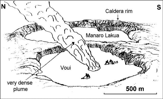 |
Figure 4. Sketch of the Aoba summit area, 3 March 1995, showing a very thick dense plume rising from Lake Voui. Based on images taken during an overflight by Vanair pilot Capt. Norman Samson; courtesy of ORSTOM. |
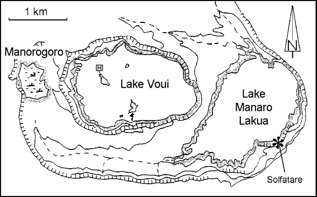 |
Figure 5. Map of the Aoba summit area (after an IGN map) showing the lakes and landing site of the helicopter on 27 June 1995. Courtesy of ORSTOM. |
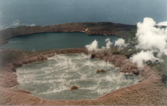 |
Figure 6. Photograph of the Aoba summit looking approximately SE, showing the steaming Lake Voui in the active crater (foreground) and Lake Manaro Lakua (background), on 20 March 1995. Convection cells ~300-400 m in diameter can be seen in Lake Voui. Courtesy of ORSTOM. |
A drop in the level of Lake Voui that began on 6 March (BGVN 20:02) was visible in photographs taken on 20 March. During another overflight on 6 April, the level of the crater lake had dropped by ~2 m. By the time of a 27 June landing on the NW island in Lake Voui (figure 5), the lake level had dropped ~5 m below the maximum, as determined by recent vegetation. Water temperatures measured around the most accessible parts of the island averaged 38-40°C, with highs of 63-67°C. The strongly acidic (pH 2.3) emerald-green lake was mostly obscured by clouds, but vapor emissions were visible between the island and the NW edge of the crater. A small island seen on 6 April in the N part of the lake had enlarged noticeably because of the drop in water level. The topography of the islands is steep towards the center of the lake and gentle towards crater edge. All of the trees on the island were dead, but other vegetation was beginning to reappear. Some blocks of dried mud (40-50 cm in diameter) ejected during the phreatic explosion at the beginning of March were still visible. Sulfur deposits were noted, and gas bubbles were coming from numerous fissures at the edge of the island.
A bathymetric survey of Lake Voui has never been done, but ORSTOM estimates that it has a volume of 50 million cubic meters. Although activity has declined in recent months, ORSTOM will maintain the current low-level alert status until approximately the end of November.
Geological Summary. The island of Ambae, also known as Aoba, is a massive 2,500 km3 basaltic shield that is the most voluminous volcano of the New Hebrides archipelago. A pronounced NE-SW-trending rift zone with numerous scoria cones gives the 16 x 38 km island an elongated form. A broad pyroclastic cone containing three crater lakes (Manaro Ngoru, Voui, and Manaro Lakua) is located at the summit within the youngest of at least two nested calderas, the largest of which is 6 km in diameter. That large central edifice is also called Manaro Voui or Lombenben volcano. Post-caldera explosive eruptions formed the summit craters about 360 years ago. A tuff cone was constructed within Lake Voui (or Vui) about 60 years later. The latest known flank eruption, about 300 years ago, destroyed the population of the Nduindui area near the western coast.
Information Contacts: M. Lardy, D. Douglas, P. Wiart, and K. Kalkaua, Centre ORSTOM, Port Vila, Vanuatu, and Bureau des Desastres Nationaux, P.M.B. 014, Port Vila, Vanuatu; M. Regnier and S. Temakon, ORSTOM et Departement des Mines et de la Geologie et des Ressources en Eaux, Port Vila, Vanuatu; Chief N. Tahi, Village de Nambangahake (Ndui-Ndui) Aoba, Vanuatu; C. Robin and M. Monzier, Centre ORSTOM, Quito, EcuadorJ-P.Eissen, Centre ORSTOM de Brest, France; J-P. Metaxian, Universite de Savoie.