Report on Mayon (Philippines) — August 1995
Bulletin of the Global Volcanism Network, vol. 20, no. 8 (August 1995)
Managing Editor: Richard Wunderman.
Mayon (Philippines) Crater glow and steam emissions
Please cite this report as:
Global Volcanism Program, 1995. Report on Mayon (Philippines) (Wunderman, R., ed.). Bulletin of the Global Volcanism Network, 20:8. Smithsonian Institution. https://doi.org/10.5479/si.GVP.BGVN199508-273030
Mayon
Philippines
13.257°N, 123.685°E; summit elev. 2462 m
All times are local (unless otherwise noted)
On the evening of 23 August, staff at the Lignon Hill Observatory in Legazpi observed moderate to intense glow from the crater of Mayon. Moderate steam emissions rising ~300 m above the summit preceded the observation of glow. The Philippine Institute of Volcanology and Seismology (PHIVOLCS) increased the Alert Level to 2, indicating that volcanic activity had increased slightly. PHIVOLCS also recommended strict compliance with the 6-km-radius permanent danger zone, an area restricted to regular human activity, especially below the Bonga channel on the SE flank. The PHIVOLCS Quick Response Team was dispatched to augment monitoring staff at the Lignon Hill and Mayon Resthouse observatories.
The summit crater continued to exhibit glow on 25 August, with varying intensity, and there was moderate steam emission. COSPEC measurements of SO2 levels in the steam plume were ~630 metric tons/day (t/d), well above the 100-200 t/d measured during quiet periods. No unusual seismicity was detected. The last sighting of crater glow was on 2 September, although it was not until 12 September that SO2 measurements by COSPEC decreased to near background.
As of mid-September, the dominant seismicity consisted of occasional high-frequency volcanic earthquakes (<5 events/day); they were large enough to be located, and occurred within the E and N parts of the edifice. Observations of the crater area disclosed that some multi-phase events were due to large lava blocks detaching from the vent. The vent is open to the SE as a result of the 1993 explosions. A preliminary investigation of a water well in Malilipot (ENE of the summit) on 25 August revealed a slight decrease in water level, also an indicator of volcanic unrest. However, further measurements of water wells on the SE and S margins of lahar fans around Mayon, where most wells are located, did not show measurable or significant changes. PHIVOLCS therefore concluded that little ground deformation was taking place.
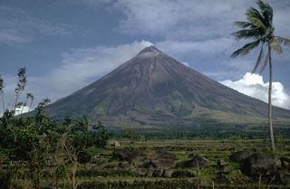
Geological Summary. Symmetrical Mayon, which rises above the Albay Gulf NW of Legazpi City, is the most active volcano of the Philippines. The steep upper slopes are capped by a small summit crater. Recorded eruptions since 1616 CE range from Strombolian to basaltic Plinian, with cyclical activity beginning with basaltic eruptions, followed by longer periods of andesitic lava flows. Eruptions occur predominately from the central conduit and have also produced lava flows that travel far down the flanks. Pyroclastic density currents and mudflows have commonly swept down many of the approximately 40 ravines that radiate from the summit and have often damaged populated lowland areas. A violent eruption in 1814 killed more than 1,200 people and devastated several towns.
Information Contacts: Ernesto G. Corpuz, Chief of Volcano Monitoring Division, Philippine Institute of Volcanology and Seismology (PHIVOLCS), 5th & 6th Floors Hizon Building, 29 Quezon Avenue, Quezon City, Philippines.

