Report on Semeru (Indonesia) — October 1995

Bulletin of the Global Volcanism Network, vol. 20, no. 10 (October 1995)
Managing Editor: Richard Wunderman.
Semeru (Indonesia) Explosions and pyroclastic flows continue
Please cite this report as:
Global Volcanism Program, 1995. Report on Semeru (Indonesia) (Wunderman, R., ed.). Bulletin of the Global Volcanism Network, 20:10. Smithsonian Institution. https://doi.org/10.5479/si.GVP.BGVN199510-263300
Semeru
Indonesia
8.108°S, 112.922°E; summit elev. 3657 m
All times are local (unless otherwise noted)
The VSI reported that by 3 August a tongue of glowing lava had reached 300 m long; at 1932 that evening the lava collapsed to feed lava avalanches. Qantas airlines reported additional activity at 1510 on 8 August, describing volcanic "smoke" near Semeru to above 4 km. Two days later, around 1530 on 10 August, a Qantas flight reported an ash cloud to 9 km altitude with a SW drift.
VSI noted that during August-October small-to-moderate explosions and avalanches continued from the Jonggring Seloko summit crater. Plumes rose to a maximum of 600 m above the summit; the average plume height was 300-500 m. In August and September, pyroclastic flows often traveled down the Kember River, then descended the Kobokan River, reaching a distance of 1-3 km. The frequency of lava avalanches increased in September, extending along the Kember River for up to 500 m from the summit.
Earthquakes associated with the pyroclastic flows were variable, with 1-16 events/day through early October; after that the frequency of earthquakes decreased. Increasing numbers of volcanic earthquakes (both A-and B-type) started on 11 October and continued until the end of the month, fluctuating at 1-14 events/day (figure 8). The number of explosion earthquakes was typically 45-109/day (figure 8), except on 26 and 27 September, when there were only 33 and 24 events, respectively.
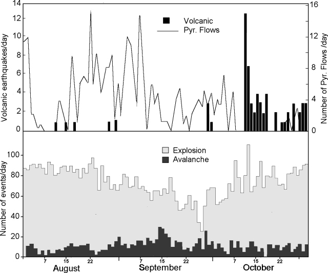 |
Figure 8. Eruptive activity at Semeru as detected by seismograph, August-October 1995: pyroclastic flows and volcanic earthquakes (top), explosions and avalanche events (bottom). Courtesy of VSI. |
Geological Summary. Semeru, the highest volcano on Java, and one of its most active, lies at the southern end of a volcanic massif extending north to the Tengger caldera. The steep-sided volcano, also referred to as Mahameru (Great Mountain), rises above coastal plains to the south. Gunung Semeru was constructed south of the overlapping Ajek-ajek and Jambangan calderas. A line of lake-filled maars was constructed along a N-S trend cutting through the summit, and cinder cones and lava domes occupy the eastern and NE flanks. Summit topography is complicated by the shifting of craters from NW to SE. Frequent 19th and 20th century eruptions were dominated by small-to-moderate explosions from the summit crater, with occasional lava flows and larger explosive eruptions accompanied by pyroclastic flows that have reached the lower flanks of the volcano.
Information Contacts: W. Tjetjep, VSI; BOM Darwin, Australia.