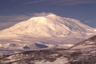
Report on Erebus (Antarctica) — December 1995
Bulletin of the Global Volcanism Network, vol. 20, no. 11 (December 1995)
Managing Editor: Richard Wunderman.
Erebus (Antarctica) No significant activity from the active lava lake; gas measurements
Please cite this report as:
Global Volcanism Program, 1995. Report on Erebus (Antarctica) (Wunderman, R., ed.). Bulletin of the Global Volcanism Network, 20:11. Smithsonian Institution. https://doi.org/10.5479/si.GVP.BGVN199512-390020
Erebus
Antarctica
77.53°S, 167.17°E; summit elev. 3794 m
All times are local (unless otherwise noted)
Significant collapse of the Inner Crater was occurring in late 1995, although the lava lake remained fairly constant in size at ~20 m diameter and generally in the same location. No significant eruptions have occurred from the lava lake over the last 5 years and no bombs have been observed on the crater rim. Magma composition has shown no change over the last 20 years. A recent volume of 12 papers (Kyle, 1994) summarizes some aspects of the volcanic activity and environmental effects of Erebus through the 1980's and early 1990's.
Passive degassing from the lake contributes a small plume and the SO2 content has usually been monitored in December by COSPEC (see Kyle and others, 1994 for COSPEC data up to 1991). Since 1991 the SO2 emissions have ranged between 40 and 70 Mg/day (megagrams/day is the SI unit equivalent to metric tons/day); bad weather limited measurements in December 1995. FTIR (Fourier Transform Infrared) open-field spectrometry measurements in December confirmed the HCl/SO2 ratio of the emitted gases to be in agreement with measurements made by impregnated filters over the last 8 years. However, high CO levels significantly exceeded those of both HCl and SO2. Although CO2 in the plume has not been measured it is assumed to be high due to the alkalic nature of the magma. The high CO may be a function of the presumed high CO2 concentrations in the magma and its fairly low oxygen fugacity.
A network of eight seismic stations are operated as part of the Erebus Volcano Observatory by the New Mexico Institute of Mining and Technology. Seven stations have 1-Hz vertical single-component instruments, and the eighth is a 1-Hz three-component station. The stations have radio telemetry links to McMurdo Station where a digital event detection system and several analog helirecorders record the data, which are automatically transferred daily via the Internet to New Mexico for analysis and archiving. Details about the seismic network and associated seismicity can be accessed on the WWW Erebus page (see below).
Magmatic eruptive activity has been continuous since the discovery of a anorthoclase phonolite lava lake in 1972 (Giggenbach and others, 1973). Activity has been relatively uniform over the last 15 years with the exception of two significant events. In 1984 there was a 3-4 month period of larger and more frequent Strombolian eruptions which ejected bombs >2 km from the summit crater. On 19 October 1993 two moderate phreatic eruptions blasted a new crater ~80 m in diameter on the Main Crater floor and ejected debris over the northern Main Crater rim. These are the first known phreatic eruptions at Erebus, and probably resulted from steam build-up associated with melting snow in the crater.
References. Giggenbach, W.F., Kyle, P.R., and Lyons, G., 1973, Present volcanic activity on Erebus, Ross Island, Antarctica: Geology, v. 1, p. 135-136.
Kyle, P.R., Sybeldon, L.M., McIntosh, W.C., Meeker, K., and Symonds, R., 1994, Sulfur dioxide emissions rates from Mount Erebus, Antarctica, in Kyle (1994), p. 69-82.
Kyle, P.R., ed., 1994, Volcanological and Environmental Studies of Erebus, Antarctica: Antarctic Research Series, American Geophysical Union, v. 66.
Geological Summary. Mount Erebus, the world's southernmost historically active volcano, overlooks the McMurdo research station on Ross Island. It is the largest of three major volcanoes forming the crudely triangular Ross Island. The summit of the dominantly phonolitic volcano has been modified by one or two generations of caldera formation. A summit plateau at about 3,200 m elevation marks the rim of the youngest caldera, which formed during the late-Pleistocene and within which the modern cone was constructed. An elliptical 500 x 600 m wide, 110-m-deep crater truncates the summit and contains an active lava lake within a 250-m-wide, 100-m-deep inner crater; other lava lakes are sometimes present. The glacier-covered volcano was erupting when first sighted by Captain James Ross in 1841. Continuous lava-lake activity with minor explosions, punctuated by occasional larger Strombolian explosions that eject bombs onto the crater rim, has been documented since 1972, but has probably been occurring for much of the volcano's recent history.
Information Contacts: Philip R. Kyle, Dept. of Earth and Environmental Sciences, New Mexico Institute of Mining and Technology, Socorro, NM 87801 USA.

