Report on Akutan (United States) — February 1996
Bulletin of the Global Volcanism Network, vol. 21, no. 2 (February 1996)
Managing Editor: Richard Wunderman.
Akutan (United States) Several days of felt earthquakes during cloudy weather
Please cite this report as:
Global Volcanism Program, 1996. Report on Akutan (United States) (Wunderman, R., ed.). Bulletin of the Global Volcanism Network, 21:2. Smithsonian Institution. https://doi.org/10.5479/si.GVP.BGVN199602-311320
Akutan
United States
54.134°N, 165.986°W; summit elev. 1303 m
All times are local (unless otherwise noted)
At 1930 on 10 March, residents of the city of Akutan on Akutan Island began feeling continuous earthquakes punctuated occasionally by strong, but non-damaging shocks. The coastal city has a seasonal population of 750 and lies 13 km E of the summit. Poor weather, which prevailed for at least the next few days, hampered visual observations of the volcano.
The strongly felt seismic activity continued throughout most of 11 March. At 1700 on 11 March, continuous tremor-like shaking in Akutan city began subsiding. A similar decrease also took place in the intensity of felt shocks and, by 2000 that day, event counts were on the decline. This decline continued through the night and into the morning of 12 March. As of the afternoon of 12 March, Akutan residents reported that they felt earthquakes at a rate of ~1/hour.
An AVO seismologist with an instrument arrived in Akutan city on the night of 12 March. Seismicity increased significantly beginning about 1700 on 13 March. Felt-earthquakes began occurring at a rate of about 1 a minute, similar to the 11 March rate.
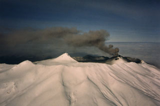
Seismic observations at distant stations, and the felt-earthquakes, suggested a very shallow volcanic source, a possible prelude to, or indication of, eruptive activity at the nearby volcano. There were, however, no reports of airborne ash or sulfurous odors. Weather cloud tops were estimated to be at about 8 km with local winds blowing toward the N. If any ash discharged, it was localized. Without direct observation, AVO postulated that if the eruptive activity took place it was characterized by periodic low-level explosions.
Forwarded reports from aviators in mid-March noted abnormal amounts of steam or possible ash coming from the crater's SE corner. Plume height estimates were from 0.9-1.2 km in one case and 3.0-4.6 km in another. At the time of one particular observation the plume's width was relatively narrow. It was given as about a quarter of the width of the volcano's base (presumably the visible base, a distance that is difficult to determine exactly). Various reports also mentioned layers of weather clouds.
Geological Summary. Akutan contains a 2-km-wide caldera with a large cinder cone in the NE part of the caldera that has been the source of frequent explosive eruptions and occasional lava effusion that covers the caldera floor. An older, largely buried caldera was formed during the late Pleistocene or early Holocene. Two volcanic centers are located on the NW flank. Lava Peak is of Pleistocene age, and a cinder cone lower on the flank produced a lava flow in 1852 that extended the shoreline of the island and forms Lava Point. The 60-365 m deep younger caldera was formed during a major explosive eruption about 1,600 years ago and contains at least three lakes. A lava flow in 1978 traveled through a narrow breach in the north caldera rim almost to the coast. Fumaroles occur at the base of the caldera cinder cone, and hot springs are located NE of the caldera at the head of Hot Springs Bay valley and along the shores of Hot Springs Bay.
Information Contacts: Alaska Volcano Observatory (AVO), a cooperative program of a) U.S. Geological Survey, 4200 University Drive, Anchorage, AK 99508-4667, USA, b) Geophysical Institute, University of Alaska, PO Box 757320, Fairbanks, AK 99775-7320, USA, and c) Alaska Division of Geological & Geophysical Surveys, 794 University Ave., Suite 200, Fairbanks, AK 99709, USA.