Report on Sangay (Ecuador) — March 1996

Bulletin of the Global Volcanism Network, vol. 21, no. 3 (March 1996)
Managing Editor: Richard Wunderman.
Sangay (Ecuador) Phreatic explosions, blue gas plumes, crater glow, and dome rockfalls
Please cite this report as:
Global Volcanism Program, 1996. Report on Sangay (Ecuador) (Wunderman, R., ed.). Bulletin of the Global Volcanism Network, 21:3. Smithsonian Institution. https://doi.org/10.5479/si.GVP.BGVN199603-352090
Sangay
Ecuador
2.005°S, 78.341°W; summit elev. 5286 m
All times are local (unless otherwise noted)
From 24 November to 12 December 1995, the first detailed study of Sangay volcano (figures 1 and 2) was carried out by an Instituto Geofísico/ORSTOM team (Escuela Politécnica Nacional, Quito), with helicopter support from the Ecuadorian Army and the assistance of five local guides from Alao. During this time, activity was characterized by continuous fumarolic steaming, frequent phreatic explosions, occasional crater glow, and dome rockfalls. Previous reports from August 1976, August 1983, and June-August 1988 (SEAN 01:10, 08:07, and 13:08) identified four summit vents aligned WSW-ENE, which are here numbered from 1 to 4 going from W to E.
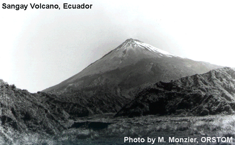 |
Figure 1. Present cone of Sangay in December 1995 viewed from the base camp 4.3 km SW. The recent pyroclastic-flow deposit on which the campsite is located is in the foreground, among the badlands corresponding to an older edifice. At the summit can be seen the W lava dome (Vent 1) and its now inactive lava tongues. Photo by M. Monzier, courtesy of ORSTOM. |
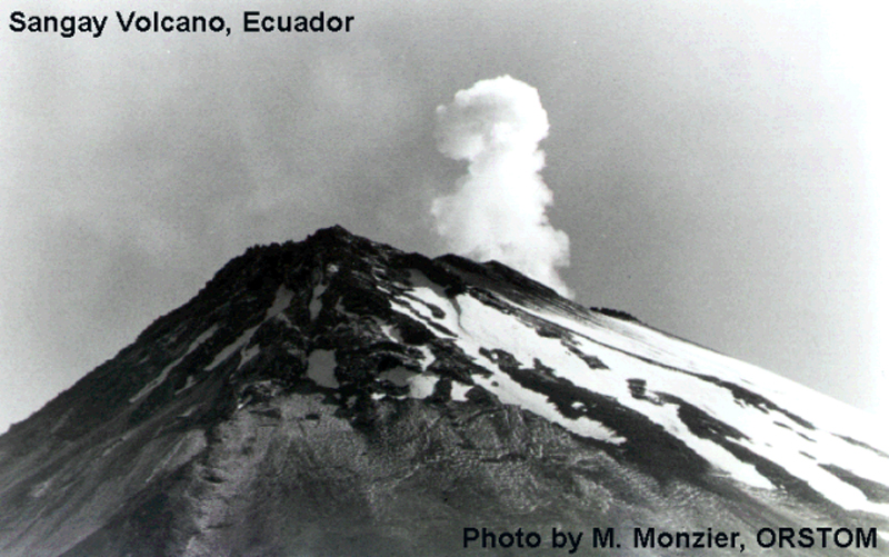 |
Figure 2. View of the Sangay summit in December 1995 looking NE from the base camp showing the lava dome and associated lava flows from Vent 1. Behind this dome, a steam plume rises from the main crater (Vent 3). Photo by M. Monzier, courtesy of ORSTOM. |
In 1976, Vent 1 consisted of a fracture from which lava was slowly issuing, but by August 1983 it had built a lava dome. This small dome was apparently more active in August 1988, and sent a lava flow 400 m down the W flank, where it split into two lobes. In late 1995 this dome was possibly still growing, and was the source of some fumarolic activity and many rockfalls, making the W and SW slopes of the cone dangerous to cross. Apparently there have been no new lava flows from this vent since August 1988. Vent 2, a small 15-m-diameter crater immediately ENE of Vent 1 has frequently been the site of explosive activity (1976 and 1983), but apparently was less active in 1988 and was quiet during the 1995 visit. The ENE crater (Vent 4) remained inactive but with occasional fumarolic activity.
Vent 3, at 80-100 m across, is the largest and deepest crater. In 1976 and 1983 only fumarolic activity was observed from this crater, but lava was reported in 1988. During the 1995 visit it was the site of frequent phreatic explosions, some separated by hours, others coming as often as every 26 minutes. Several explosions were followed by a rhythmic, pulsating roar that lasted for up to 50 oscillations. White vapor plumes, ejected with the audible explosions, rose several hundred meters above the summit. Light blue gas plumes and occasional red glow at night immediately above this crater implied the presence of lava. Frequent rockfalls from the upper S flank of the cone suggested that some lava may be escaping, breaking off, and rolling down the S slopes.
During the visit a portable MEQ-800 Sprengnether seismograph with a vertical, 1-Hz L4C geophone was operated at the La Playa base camp, 4.3 km SW of the main crater at 3,600 m elevation. A preliminary study of the smoked-paper seismograms showed three types of seismic signals, frequently associated with observed explosions in the crater (figures 3 and 4): tremor, long-period, and hybrid events. Tremor events had a monochromatic signature with a period of 1 second and lasted < 60 seconds. The long-period events had emergent arrivals and a constant period of ~0.7 seconds; they were often associated with observed explosions. Hybrid events began with a long-period event (0.7 seconds) and were followed by a signal similar to that of the tremor (1 second). Some hybrid events were associated with audible and observed explosions followed by a roar like pulsating, rhythmic exhalations. No local high-frequency events were detected.
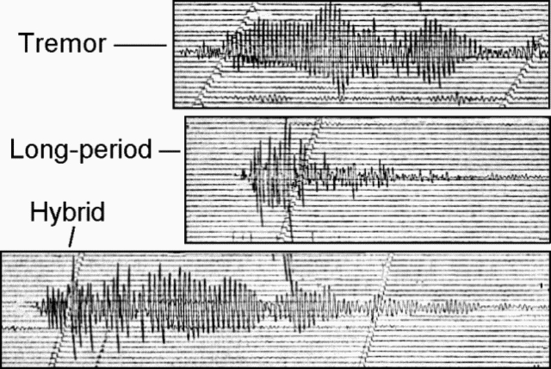 |
Figure 3. Types of volcanic earthquakes at Sangay recorded by the seismic station 4.3 km SW in December 1995. Courtesy of ORSTOM. |
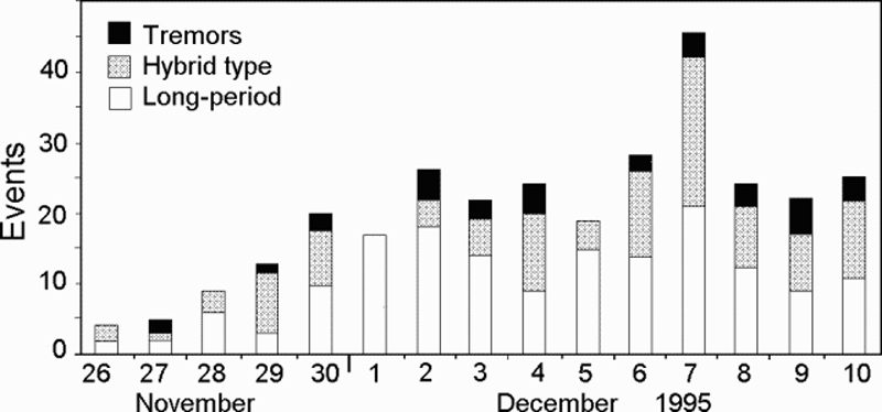 |
Figure 4. Volcanic seismicity recorded at Sangay, 26 November-10 December 1995. Courtesy of ORSTOM. |
Recent lavas and pyroclastic-flow, debris-flow, and lahar deposits are ubiquitous around the cone and testify to Sangay's nearly continuous activity. The site of the La Playa camp (figure 5) is on an andesitic pyroclastic-flow deposit containing bombs up to 4 m in diameter which was emplaced between 1956 and 1965. An accident with two fatalities happened in August 1976 (SEAN 01:10). A previously unreported accident occurred in December 1993 when the main crater exploded just as two mountaineers looked over its rim. Both were blinded by the heat and fragment impacts and remained lost in the jungle on the cone's lower slopes until rescued three days later.
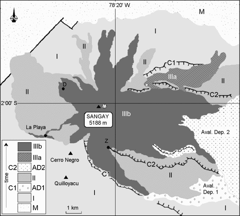 |
Figure 5. Preliminary geological/structural map of Sangay volcano based on fieldwork, aerial photographs, and 1:50,000 topographic maps from the Instituto Geografico Militar, Quito. Key: M = metamorphic formations; I, II, III = successive volcanic edifices; C1 and C2 = avalanche calderas; AD = avalanche deposits. Campsites are shown as black dots (La Playa = basecamp, Z = Zumbacocha and D = Duende are secondary camps). |
In addition to the present cone (Sangay III), two previous edifices were identified and sampled, both of which had been destroyed by collapse. The remnant calderas are found on the E side of the present cone and are breached E toward the Amazon plain. Their probable avalanche deposits lie at the E foot of the cone. A preliminary geologic map of Sangay (figure 5) shows the three successive edifices and the two associated calderas. Edifice I is mainly built of lava, whereas edifices II and III contain both lava and pyroclastic deposits. The products of edifices I and II appear to be more varied in composition (greater differentiation) than those of Sangay III, where mafic andesites seem to predominate.
This isolated stratovolcano E of the Andean crest is one of Ecuador's most active volcanoes having been in frequent eruption for the past several centuries. The steep-sided glacier-covered volcano towers above the tropical jungle on the E side; on the other sides heavy rains have caused plains of ash to be sculpted into steep-walled canyons up to 600 m deep. The first historical eruption was reported in 1628, and more or less continuous eruptions took place from 1728 until 1916, and again from 1934 to the present.
Geological Summary. The isolated Sangay volcano, located east of the Andean crest, is the southernmost of Ecuador's volcanoes and its most active. The steep-sided, glacier-covered, dominantly andesitic volcano grew within the open calderas of two previous edifices which were destroyed by collapse to the east, producing large debris avalanches that reached the Amazonian lowlands. The modern edifice dates back to at least 14,000 years ago. It towers above the tropical jungle on the east side; on the other sides flat plains of ash have been eroded by heavy rains into steep-walled canyons up to 600 m deep. The earliest report of an eruption was in 1628. Almost continuous eruptions were reported from 1728 until 1916, and again from 1934 to the present. The almost constant activity has caused frequent changes to the morphology of the summit crater complex.
Information Contacts: M. Monzier and C. Robin, ORSTOM, A.P. 17-11-6596, Quito, Ecuador; M. Hall, P. Mothes, and P. Samaniego, Instituto Geofísico, Escuela Politécnica Nacional, A.P. 17-01-2759, Quito, Ecuador.