Report on Izu-Oshima (Japan) — August 1996
Bulletin of the Global Volcanism Network, vol. 21, no. 8 (August 1996)
Managing Editor: Richard Wunderman.
Izu-Oshima (Japan) Seismic activity increases
Please cite this report as:
Global Volcanism Program, 1996. Report on Izu-Oshima (Japan) (Wunderman, R., ed.). Bulletin of the Global Volcanism Network, 21:8. Smithsonian Institution. https://doi.org/10.5479/si.GVP.BGVN199608-284010
Izu-Oshima
Japan
34.724°N, 139.394°E; summit elev. 746 m
All times are local (unless otherwise noted)
On 5 August a shallow low-frequency earthquake occurred beneath the top of the volcano. On the early morning of 22 August, seismicity increased on the W flank of Oshima and 8 earthquakes were felt. At the seismic station 4 km NW of the vent (Station C), 164 earthquakes were recorded on 22 August. The largest earthquake (M 2.5) was detected at 0136 on 22 August. On 24 August an earthquake was also felt. A total of 222 earthquakes was registered at Station C in August.
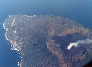
Geological Summary. Izu-Oshima volcano in Sagami Bay, east of the Izu Peninsula, is the northernmost of the Izu Islands. The broad, low stratovolcano forms an 11 x 13 km island constructed over the remnants of three older dissected stratovolcanoes. It is capped by a 4-km-wide caldera with a central cone, Miharayama, that has been the site of numerous recorded eruptions datining back to the 7th century CE. More than 40 cones are located within the caldera and along two parallel rift zones trending NNW-SSE. Although it is a dominantly basaltic volcano, strong explosive activity has occurred at intervals of 100-150 years throughout the past few thousand years. A major eruption in 1986 produced spectacular lava fountains up to 1,600 m high and a 16-km-high eruption column; more than 12,000 people were evacuated from the island.
Information Contacts: Volcanological Division, Japan Meteorological Agency (JMA), 1-3-4 Ote-machi, Chiyoda-ku, Tokyo 100, Japan.