Report on Nyiragongo (DR Congo) — October 1996

Bulletin of the Global Volcanism Network, vol. 21, no. 10 (October 1996)
Managing Editor: Richard Wunderman.
Nyiragongo (DR Congo) No visible activity in April and August; summary of 1994-95 activity
Please cite this report as:
Global Volcanism Program, 1996. Report on Nyiragongo (DR Congo) (Wunderman, R., ed.). Bulletin of the Global Volcanism Network, 21:10. Smithsonian Institution. https://doi.org/10.5479/si.GVP.BGVN199610-223030
Nyiragongo
DR Congo
1.52°S, 29.25°E; summit elev. 3470 m
All times are local (unless otherwise noted)
Members of an SVE excursion who climbed Nyiragongo during the second week of April 1996 found no visible eruptive activity. They heard from local residents that the eruption that began in June 1994 (BGVN 19:06-19:08) had ended in September 1995.
Whether the eruption actually ceased in September 1995 is ambiguous because Dario Tedesco learned that in November 1995 and in February-March 1996 observers saw glow above the crater at night. Also, Tedesco learned that some tourists spending the night near the summit during this same post-September interval allegedly saw minor activity. Some sustained seismic activity was reported in September through early December 1995 (BGVN 21:01).
Observations on 3 August 1996. Christoph Weber visited the volcano on 3 August 1996 and made a rough sketch map (figure 9). Weber also saw no new activity and based on discussions with locals concluded that the last eruptions consisted of the lava fountains and lava lake dynamics that took place in the interval July 1994 to September 1995 (BGVN 20:01 and 21:01).
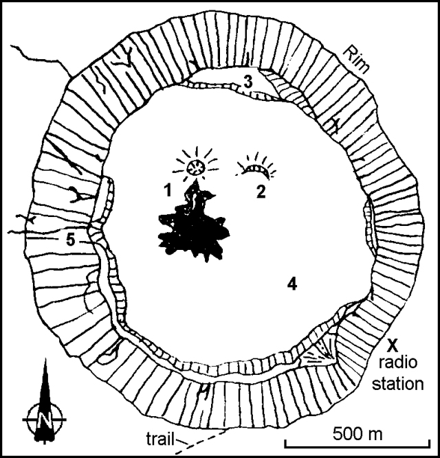 |
Figure 9. Nyiragongo sketch map showing the crater in August 1996. Symbols are as follows: 1) Spatter cone with last lava flows (shaded); 2) spatter half-cone; 3) first platform (or bench, ~175 m below the crater rim); 4) surface of chilled lava lake and associated lava flows (~275 m below the rim); and 5) dikes. Courtesy of Christoph Weber. |
Features in the crater area included a spatter cone, a feature bordered on its S side with a light gray lava flow (dark shading). This flow was apparently the last erupted prior to the visit and it still showed fresh-looking flow channels. Weak fumaroles were located along the SE crater's wall at concentric fractures ~50-150 m below the crater rim. Weber also relayed that seismologist Mahinda Kasereka had seen typical seismicity around this time interval.
Reported activity during November 1994-August 1995. Tedesco elaborated on activity from November 1994 to as late as March 1995, describing almost continuous lava lake activity. The lake lay within the confines of a spatter cone 50 m high and 100 m across. Lava escaping at the spatter cone's base formed two main flows that expanded into an intracrater depression. Theodolite measurements, however, indicated that during this interval the crater floor lacked detectible inflation. During this time period the Goma Observatory seismic system registered tremor and local earthquakes tens of kilometers N and W of the Nyiragongo crater.
Some time around March to early April 1995 activity changed significantly, Tedesco reported. There were seismic swarms and high lava fountains (the latter previously unseen since November 1994), marked effects presumably due to the availability of a fresh batch of undegassed magma. Suddenly, in mid-April the activity ceased for a couple of weeks; the spatter cone disappeared leaving only a much smaller hole located farther towards the N crater wall; inside the hole a solid crust covered the floor.
Tedesco also reported that at the end of April, after a M 5.1 earthquake in the region, there occurred about one eruptive episode/week lasting up to 12 hours. Two spatter cones formed. From the end of April to mid-August 1995 accumulating lavas caused the crater floor to ascend by ~50 m and the estimated erupted lava volume was 56 x 106 m3. This volume was ~3x larger than the volume estimated by Tazieff for the 1977 lava flows. The latter estimates were made from oblique photographs, without aerophotogrammetric maps, and by accepting an overall average flow thickness of 1 m for a flow that ranged from 0 to 3 m thick (Tazieff, 1977, p. 193).
Eruptive history. A previous lava lake in the deep summit crater of Nyiragongo, active intermittently since 1894, drained suddenly on 10 January 1977. Extremely fluid lava escaped from flank fissures and moved downslope at up to 60 km/hour, killing about 70 people. Lava lake activity resumed in June 1982 with phreatic explosions and lava fountaining, but had ceased by early 1983 (Tazieff, 1984; Tazieff, 1979). The lava lake was again active at least into early 1995 (BGVN 20:01) after an eruption that began in June 1994 (BGVN 19:06-19:08). For the past two and a half years this portion of Zaire's border had contained camps with hundreds of thousands of refugees; over a month ago these refugees fled to escape fighting.
References. Tazieff, H., 1977, An exceptional eruption, Mt. Niragongo, Jan. 10th, 1977: Bull. Volcanol., v. 40-3, p. 189-200.
Tazieff, 1979, Nyiragongo, the forbidden volcano (translation from French language text by J.F. Barnard): Barron's Educational Series, Inc., Woodbury New York, 287 p.
Tazieff, H., 1984, Mt. Niragongo: renewed activity of the lava lake: Jour. Volc. Geotherm. Res., v. 20, p. 267- 280
Geological Summary. The Nyiragongo stratovolcano contained a lava lake in its deep summit crater that was active for half a century before draining catastrophically through its outer flanks in 1977. The steep slopes contrast to the low profile of its neighboring shield volcano, Nyamuragira. Benches in the steep-walled, 1.2-km-wide summit crater mark levels of former lava lakes, which have been observed since the late-19th century. Two older stratovolcanoes, Baruta and Shaheru, are partially overlapped by Nyiragongo on the north and south. About 100 cones are located primarily along radial fissures south of Shaheru, east of the summit, and along a NE-SW zone extending as far as Lake Kivu. Many cones are buried by voluminous lava flows that extend long distances down the flanks, which is characterized by the eruption of foiditic rocks. The extremely fluid 1977 lava flows caused many fatalities, as did lava flows that inundated portions of the major city of Goma in January 2002.
Information Contacts: Patrick Barois, c/o Henry Gaudru, Société Volcanologique Européenne (SVE), C.P. 1, 1211 Geneva 17, Switzerland; Christoph Weber, Kruppstrasse 171, 42113 Wuppertal, Germany; Mahinda Kasereka, Goma Volcano Observatory, Departement de Geophysique, Centre de Recherche en Sciences Naturelles, Lwiro, D.S. Bukavu, Zaire; Dario Tedesco, Universita degli Studi di Napoli Federico II, Dipartimento di Geofisica e Vulcanologia, Napoli, Italy.