Report on Manam (Papua New Guinea) — December 1996

Bulletin of the Global Volcanism Network, vol. 21, no. 12 (December 1996)
Managing Editor: Richard Wunderman.
Manam (Papua New Guinea) Paroxysmal eruptions on 3 December cause 13 deaths
Please cite this report as:
Global Volcanism Program, 1996. Report on Manam (Papua New Guinea) (Wunderman, R., ed.). Bulletin of the Global Volcanism Network, 21:12. Smithsonian Institution. https://doi.org/10.5479/si.GVP.BGVN199612-251020
Manam
Papua New Guinea
4.08°S, 145.037°E; summit elev. 1807 m
All times are local (unless otherwise noted)
A series of large eruptions took place during October and November, and culminated with a paroxysmal phase on 3 December. The paroxysm accounted for 13 deaths in a coastal village called Budua Old near SW Valley (figure 7).
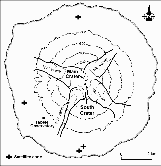 |
Figure 7. Sketch map of Manam Island, showing the distribution of the four valleys. After Palfreyman and Cooke, 1976. |
After the last large eruption in 1992 (BGVN 17:09-17:11), Main Crater remained inactive with weak vapor emissions, while South Crater showed intermittent phases of weak to moderate, mainly Strombolian, activity. Mild Vulcanian explosions resumed at both craters in mid-September 1996 (BGVN 21:09), and Strombolian eruptions returned to both craters in October. During October and November, five strong phases of activity occurred at Main Crater at intervals of 7-12 days; four of them were preceded or accompanied by moderate activity at South Crater (figure 8). From early October to 10 November, the first four phases progressively increased in strength, and were accompanied by a large buildup in seismic amplitude (figure 9). Like the strongest phase of the 1992 eruption (BGVN 17:09-17:11), the first four phases of eruptions at Main Crater produced pyroclastic flows and lava flows in NE Valley.
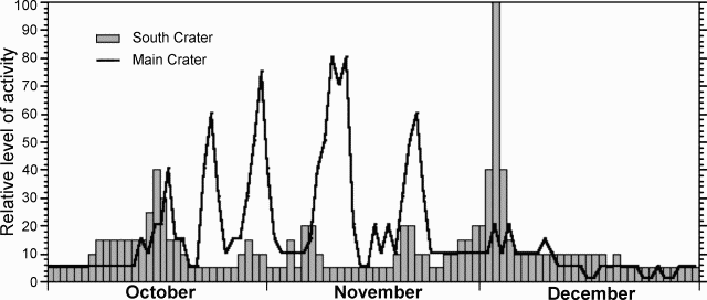 |
Figure 8. A rough (qualitative) estimate of the level of October-December volcanic activity at Manam. Activity is shown as a relative scale that is arbitrary, with the highest intensity artificially set at "100". Courtesy of RVO. |
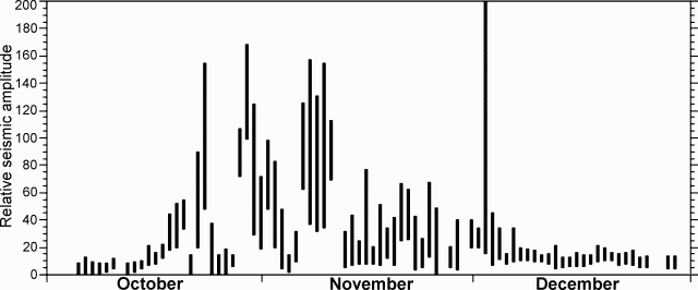 |
Figure 9. Relative seismic amplitude during October-December at Manam. Courtesy of RVO. |
At South Crater, ash-laden emissions, roaring sounds, and fluctuating glows occurred on 19 November, and moderate Strombolian projections (200 m high) and ash-laden emissions (~700 m high) were observed on 20-21 November. The fifth phase of eruptions at Main Crater took place on 20-22 November. On 20 November, Main Crater produced frequent roaring sounds, bright fluctuating night glows, and up to ~800-m-high brown emissions, indicating deep-seated Strombolian activity. Strombolian eruptions were sub-continuous until 1800 on 21 November, with a 3-km high, dark, convoluting column. Several lava tongues traveled down the upper part of NE Valley, and reached an altitude of 600-700 m. On 22 November two lava flows moved down to an altitude of ~200 m in the central and N parts of the valley. On the afternoon of 22 November, the fifth eruptive phase declined, and the Strombolian activity changed to 2-3 km high, thick, gray emissions, which were accompanied by jet sounds. Frequency, volume, and height of the emissions progressively decreased during the next two days.
On 28 November, eruptive activity at South Crater increased with the emissions of weak to moderate, gray-brown plumes (up to 500 m high) and occasional Strombolian projections (~50 m high). On 29 November, emissions became sub-continuous. In the next two days Strombolian projections progressively rose as high as 100-200 m above the crater. At Main Crater, white to gray ash clouds were occasionally released, and glow was seen at night from two locations on the NE rim of the crater. On 30 November, emissions at Main Crater were thick and continuous, but no strong activity was observed.
Strombolian explosions at South Crater increased in strength (occasionally up to heights of 400 m) and frequency (at 1-2 minute intervals) on the morning of 2 December, died out in the afternoon, then resumed in the night. On the morning of 3 December, Strombolian explosions occurred at ~1 minute intervals with ~200-m-high projections, and light gray plumes rose ~500 m high. Seismicity increased but was still in the normal range. Strombolian projections were sub-continuous until 1300, and reached as high as 300 m above the crater. At 1430 explosions took place every a few seconds with heavy scoria falls on the upper cone, similar to the situations in the strongest phases of the 1984, 1987, and 1992 eruptions (SEAN 09:02, 09:03, 12:06, and BGVN 17:09-17:11), which sent pyroclastic flows and lava flows into the SE and SW Valleys.
Large pyroclastic flows started to move into SE Valley at about 1500, and into SW Valley around 1505. The central eruption column became thicker as it incorporated the ash cloud elutriated above the pyroclastic flows. At 1510 ash clouds that were generated by the pyroclastic flows moved down SE Valley and extended over the ground at 400-600 m above sea level. At 1515 the dark central billowing pillar reached an altitude of ~5 km, and spread W of the island. Dense ash and scoria falls caused darkness in the W part of the island for 90 minutes. Pyroclastic flows continuously moved into both SE and SW Valleys at short intervals. At 1520 one large pyroclastic flow in SW Valley reached the sea and was followed by many others. Approximately at that time, pyroclastic flows overran the village of Budua Old, resulting in 13 deaths. The devastated area extended ~1.5 km on either side of the central channel of SW Valley. In SE Valley, pyroclastic flows started to reach the sea around 1530. The overriding ash clouds progressed <100 m offshore. However, within ~10 minutes bubbles were seen piercing the water surface as far as 500 m offshore, indicating that underwater propagation of the hot pyroclastic flows reached quite a distance from the shoreline.
The central column was very dense. Eruption sounds were muffled to a continuous deep roar. Although emitted at South Crater, some pyroclastic flows moved into NE Valley and descended to mid-slope, but none was able to override the 100-m vertical valley walls that protect the cultivated and inhabited flanks of the island. At 1605 the pitch of the roaring sound slightly decreased, indicating the beginning of decline in eruptive activity. By 1615 pyroclastic flows no longer reached the sea, and at 1630 all pyroclastic flows stopped. At 1645-1700 ash began to fall again on the downwind (W-NW) side of the island. At night Strombolian activity continued at South Crater, with ~3 loud explosions every hour. At 0925 on 4 December, a large hot avalanche moved down SW Valley to an altitude of ~20 m. Explosions occurred at South Crater with decreasing strength and frequency until 7 December.
At Main Crater, two vents were active with intermittent, thick, dark, convoluting clouds on the morning of 3 December. Moderately thick, gray clouds were observed rising 500-1,000 m above the crater, with weak night glows until 15 December.
The paroxysmal eruption on 3 December changed the configuration of South Crater by sculpting a 100-m-deep, V-shaped crack NW-SE across the summit. There was an absence of high-frequency earthquakes during and after the paroxysm. This suggested that the crack, which had a similar alignment to one pair of valleys, may have pre-dated the eruption, having been covered by earlier eruption debris. Blocks up to 4 m in size from the crater wall were found in pyroclastic-flow deposits in the lower part of SW Valley.
Neither the start of the 1996 eruption nor its strong phases were anticipated by monitoring results. Ground deformation, monitored by the water tube tiltmeters at Tabele Observatory (figure 7), showed steady conditions between April and mid-September. Resumption of activity at both craters in mid-September accompanied a hardly discernible radial deflation (~0.5 µrad). From then to 8-12 November, the tiltmeters accumulated a barely significant ~1 µrad radial inflation, and thereafter a slight deflation (~1 µrad). However, a remarkable deflation of ~1.5 µrad was recorded during the paroxysm at South Crater.
Reference. Palfreyman, W.D., and Cooke, R.J.S., 1976, Eruptive history of Manam volcano, Papua New Guinea in Johnson R.W. (ed.), Volcanism in Australasia, Elsevier, Amsterdam, p. 117-131.
Geological Summary. The 10-km-wide island of Manam, lying 13 km off the northern coast of mainland Papua New Guinea, is one of the country's most active volcanoes. Four large radial valleys extend from the unvegetated summit of the conical basaltic-andesitic stratovolcano to its lower flanks. These valleys channel lava flows and pyroclastic avalanches that have sometimes reached the coast. Five small satellitic centers are located near the island's shoreline on the northern, southern, and western sides. Two summit craters are present; both are active, although most observed eruptions have originated from the southern crater, concentrating eruptive products during much of the past century into the SE valley. Frequent eruptions, typically of mild-to-moderate scale, have been recorded since 1616. Occasional larger eruptions have produced pyroclastic flows and lava flows that reached flat-lying coastal areas and entered the sea, sometimes impacting populated areas.
Information Contacts: B. Talai, I. Itikarai, and P. de Saint Ours, RVO; NOAA/NESDIS Satellite Analysis Branch; Room 401, 5200 Auth Road, Camp Springs, MD 20746, USA.