Report on Soufriere Hills (United Kingdom) — August 1997

Bulletin of the Global Volcanism Network, vol. 22, no. 8 (August 1997)
Managing Editor: Richard Wunderman.
Soufriere Hills (United Kingdom) Vigorous dome growth continues in August
Please cite this report as:
Global Volcanism Program, 1997. Report on Soufriere Hills (United Kingdom) (Wunderman, R., ed.). Bulletin of the Global Volcanism Network, 22:8. Smithsonian Institution. https://doi.org/10.5479/si.GVP.BGVN199708-360050
Soufriere Hills
United Kingdom
16.72°N, 62.18°W; summit elev. 915 m
All times are local (unless otherwise noted)
Most of the following condenses reports from the Montserrat Volcano Observatory (MVO) for August 1997. Vigorous dome growth continued during August and exhibited cyclical patterns of tilt and seismicity, rockfalls, the growing dome's extruding and falling spines, and abundant pyroclastic flows. In addition, NOAA's Satellite Analysis Branch (SAB) reported numerous ash clouds commonly blowing W to NW for tens to hundreds of kilometers. The clouds appeared in GOES satellite images, which are increasingly accessible on the world-wide web. Sketches of a few of these plume images during mid-1997 appear in figure 30. Given the persisting crisis, it is worth noting that the SAB also broadcasts forecasts of the plume's predicted trajectory after energetic eruptions for the benefit of aviators.
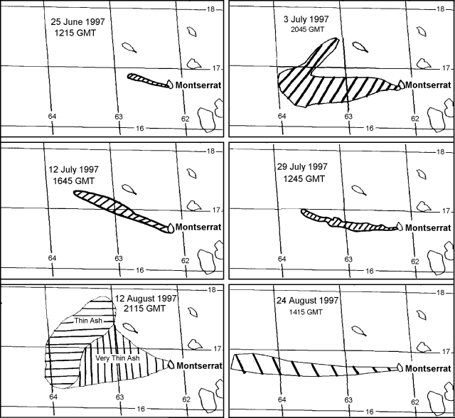 |
Figure 30. Examples of ash plumes from Soufriere Hills documented during mid-1997. Courtesy of SAB. |
Tilt and seismicity. The period 31 July to 20 August was characterized by elevated levels of seismic activity. During 1-6 August tiltmeter readings revealed a cyclic pattern with a 10- to 14-hour periodicity. During this time, regular deflation and inflation of the volcano corresponded with earthquake swarms and continuous pyroclastic flows, respectively. Continuous and near-continuous tremor of varying frequency was noted during several swarms in this period. This pattern is similar to those reported in BGVN 22:06. In addition, on 2 August several very large hybrid events occurred during a hybrid earthquake swarm; at 0900 the hybrid earthquakes peaked at ~3 events/minute with continuous moderate tremor between events.
The 10- to 14-hour cycle continued until 9 August when the pattern was broken with an explosion at 2051. An eruption comprised of several intense bursts caused heavy ash and pumice fall in Old Towne (Plymouth). A new pattern then emerged during 10 to 16 August in which cyclic activity was dominated by hybrid earthquakes and dome growth. Hybrid earthquakes appeared in swarms that were thought to be associated with extrusion of new dome material; the high level of seismic activity suggested a rapid extrusion rate. By 17 August this pattern had become less regular with longer intervals and higher intensity tremors at the end of swarms. After a 17 August swarm, tremor lasting 90 minutes was followed by 6 minutes of well-defined monochromatic seismicity. During 18- 20 August the cycle of alternating hybrid swarms and dome growth developed an 8-hour period.
Seismicity diminished during 21 to 29 August, an interval when rockfall and pyroclastic flow signals were dominant. The chief cyclical pattern noted during this interval took place during 23-26 August: enhanced seismicity at intervals of 12-15 hours. The cycle's peak coincided with modest ash emissions and rockfalls. On 30 and 31 August, activity was reported to be increasing and a 10-hour cycle had become evident.
Pyroclastic flows and ash plumes. During 1-4 August several new pyroclastic flows were reported on the NW flank in the Gages Valley. At 1800 on 3 August a major N-flank flow reached Gages Village and Port Plymouth, causing fires and damage to buildings. The flow was associated with strongly convecting ash plumes that rose up to ~4.6 km altitude and heavy W-flank ashfalls.
On the afternoon of 4 August a dark gray jet was seen projecting from the N flank at 60 degrees to the horizontal, and extending to a height of 600 m. This was followed by pyroclastic flows into the Gages, Mosquito, and Tar River valleys. A vertical ash cloud rose to over ~7.6 km and fragments of rock and pumice up to 11.5 cm diameter fell at the observatory.
On 5 August two periods of intense activity were followed by violent explosions and energetic pyroclastic flows. MVO field teams saw pyroclastic flows enter the sea at the mouth of the Tar River; they covered ~80% of the delta. Researchers investigated submerged portions of the Tar River fan on 25 August. Many of the 5 August pyroclastic flows were subsequently described as rich in pumice, and in addition to the Tar, they also followed the Tuitts, Mosquito, and Gages valleys. Falling pumice reached 8 cm in length; meter-sized impact craters formed up to 1.5 km S of the dome. After the pyroclastic flows there followed a succession of explosive pulses emitting ash at 20- to 30-second intervals; these pulses coincided with elevated 1-Hz harmonic tremor lasting up to 40 minutes.
From 6 to 9 August there were several explosions followed by ash clouds to altitudes of ~5-7 km. Pumice fall and pyroclastic flows were also reported after the explosions. On 7 August field teams saw an ash plume ascend to 1 km at a maximum rate of 47 m/s. From 11 to 31 August, numerous smaller explosions and flows were reported. Throughout the month ash plumes rose up to ~2.4 km, enhanced steaming was coincident with elevated seismicity, and there were small diffuse pyroclastic flows.
Crater observations and measurement. Although high activity occurred during the first week of August, it was not until 7 August that the summit was visible for the first time since July. On 7 August the dome's top contained a bowl-shaped crater oriented with its lower edge facing Gages Mountain. Also, the Gages Valley had become deeply incised. A deep, oval-shaped scar formed from the several small explosions during 6-9 August; on 10 August observers saw new dome material refilling the scar.
On 11 August, the MVO reported theodolite measurements of the new crater taken during clear conditions around 9 August. The crater's volume was 5-7 million cubic meters; the highest point on the dome was measured at 995 m elevation. EDM measurements were also taken on the line from Lee's Yard to Waterworks on several occasions in August; these revealed slow shortening.
A GPS survey conducted on 12 August indicated that a deformation event has occurred in the last 3 months, shifting sites at Whites and Long Ground by about 3 cm N and NE. The results of the survey also suggested that by the end of the interval this movement had slowed or ceased.
On 12 August, a very large spine was observed in the crater, but by the next day it had broken into thirds. A view on 14 August revealed a new cluster of spines above a steep chute at the head of Gages Valley. By 19 August, an area 150 m in diameter perched above Gages wall. It was composed of a series of tall spines; the top of one measured at 969 m. Six days later, on 25 August, it was noted that the mass of spines above Gages wall was breaking up and pyroclastic flows funneled down the Gages valley.
On 27 August fumaroles, rockfalls, and incandescence were noted on the dome's SE flank, an area that had been lacking in recent activity. A secondary phreatic explosion occurred on 30 August after pyroclastic flows had buried a small pond. By 31 August a deep gully had eroded into the deposits below the dome.
Cronan and others (1997) studied Montserrat's hydrothermal discharges in 1995 at spots a few kilometers N of Plymouth near the coast, both on and offshore. The chemical composition of offshore discharges varied the most; for iron, the extreme example, the offshore compositional variation was 300-fold. Temperature also varied at the offshore springs. The authors made a case for monitoring submarine hydrothermal discharges as a means to help predict future eruptions.
Many news reports in the month of August focused on either the ongoing destruction of Plymouth or the lives of people dislocated by the eruption. Press coverage was further heightened when residents made mid-month protests appealing for more governmental support.
For those readers interested in the history of Soufriere Hills, work by Jaggar (1937a, 1937b) and Perret (1939) dealt with the 1933-37 seismic crisis centered at Gages Soufriere. The crisis included abnormal fumarolic activity, earthquakes centered at Gages, and earthquake counts reaching thousands of events per month. Yet, the crisis did not lead to eruptions. Both reports contained an interesting array of experiments and then-new technologies.
References. Cronan, D.S., Johnson, A.G., and Hodkinson, R.A., 1997, Hydrothermal fluids may offer clues about impending volcanic eruptions: Eos, Transactions, American Geophysical Union, p. 341 and 345.
Perret, F.A., 1939, The volcano-seismic crisis at Montserrat, 1933-1937: Washington, D.C., Carnegie Institution of Washington, 76 p.
Jaggar, T.A., 1937A, Adventures and methods in studying West Indian volcanoes, in The Volcano Letter, no. 437 (July 1936, p. 6-7), compiled and reprinted in 1987, edited by Fiske, R.S. and others: Washington, D.C. [ISSN 0890-1996], Smithsonian Institution Press.
Jaggar, T.A., 1937b, Work of F.A. Perret on Montserrat, in The Volcano Letter, no. 449 (July 1937, p. 1-7), compiled and reprinted in 1987, edited by Fiske, R.S. and others: Washington, D.C. [ISSN 0890- 1996], Smithsonian Institution Press.
Geological Summary. The complex, dominantly andesitic Soufrière Hills volcano occupies the southern half of the island of Montserrat. The summit area consists primarily of a series of lava domes emplaced along an ESE-trending zone. The volcano is flanked by Pleistocene complexes to the north and south. English's Crater, a 1-km-wide crater breached widely to the east by edifice collapse, was formed about 2000 years ago as a result of the youngest of several collapse events producing submarine debris-avalanche deposits. Block-and-ash flow and surge deposits associated with dome growth predominate in flank deposits, including those from an eruption that likely preceded the 1632 CE settlement of the island, allowing cultivation on recently devegetated land to near the summit. Non-eruptive seismic swarms occurred at 30-year intervals in the 20th century, but no historical eruptions were recorded until 1995. Long-term small-to-moderate ash eruptions beginning in that year were later accompanied by lava-dome growth and pyroclastic flows that forced evacuation of the southern half of the island and ultimately destroyed the capital city of Plymouth, causing major social and economic disruption.
Information Contacts: Montserrat Volcano Observatory (MVO), c/o Chief Minister's Office, PO Box 292, Plymouth, Montserrat (URL: http://www.mvo.ms/); NOAA/NESDIS Satellite Analysis Branch (SAB), Room 401, 5200 Auth Road, Camp Spring, MD 20746, USA.