Report on Amukta (United States) — September 1997
Bulletin of the Global Volcanism Network, vol. 22, no. 9 (September 1997)
Managing Editor: Richard Wunderman.
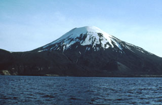
Amukta (United States) Ash puff on 2 March rises to just above the summit
Please cite this report as:
Global Volcanism Program, 1997. Report on Amukta (United States) (Wunderman, R., ed.). Bulletin of the Global Volcanism Network, 22:9. Smithsonian Institution. https://doi.org/10.5479/si.GVP.BGVN199709-311190
Amukta
United States
52.5°N, 171.252°W; summit elev. 1066 m
All times are local (unless otherwise noted)
On 2 March a pilot reported a small eruption at Amukta volcano in the central Aleutian Islands. Ash barely clearing the top of the volcano was reported.
Geological Summary. The symmetrical Amukta stratovolcano lies in the central Aleutians SW of Chagulak Island and is the westernmost of the Islands of the Four Mountains group. The stratovolcano was constructed at the northern side of an arcuate caldera-like feature that is open to the sea along the southern coast of the 8-km-wide Amukta Island. It overlies a broad shield volcano and is topped by a 400-m-wide crater, and a cinder cone is located near the NE coast. There have been several reported eruptions from both summit and flank vents.
Information Contacts: Alaska Volcano Observatory (AVO), a cooperative program of a) U.S. Geological Survey, 4200 University Drive, Anchorage, AK 99508-4667, USA (URL: http://www.avo.alaska.edu/), b) Geophysical Institute, University of Alaska, PO Box 757320, Fairbanks, AK 99775-7320, USA, and c) Alaska Division of Geological & Geophysical Surveys, 794 University Ave., Suite 200, Fairbanks, AK 99709, USA.