Report on Manam (Papua New Guinea) — November 1998

Bulletin of the Global Volcanism Network, vol. 23, no. 11 (November 1998)
Managing Editor: Richard Wunderman.
Manam (Papua New Guinea) Energetic outbursts lead to pyroclastic flows, lava flows
Please cite this report as:
Global Volcanism Program, 1998. Report on Manam (Papua New Guinea) (Wunderman, R., ed.). Bulletin of the Global Volcanism Network, 23:11. Smithsonian Institution. https://doi.org/10.5479/si.GVP.BGVN199811-251020
Manam
Papua New Guinea
4.08°S, 145.037°E; summit elev. 1807 m
All times are local (unless otherwise noted)
Following one month of build-up in seismicity and radial tilt (figure 10), intensive eruptive activity resumed on 5 October 1998—the first since its fatal eruption of November-December 1996 (BGVN 21:12).
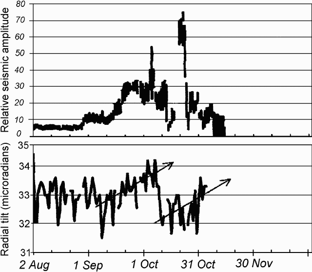 |
Figure 10. Seismicity and radial tilt from a water-tube instrument at Manam, August-October 1998. Courtesy of RVO. |
Visible increases in activity started on 23-25 September, with intermittent dark ash emissions and night-time incandescent projections to ~200 m above South Crater. In subsequent days of October, the activity decreased to continuous white vapor emissions, first profuse then very weak, and occasional roaring sounds and fluctuating glow. This corresponded to a slight decrease in seismic amplitude levels, but the radial tilt continued to show inflation.
On the morning of 5 October a rapid build-up of activity took place. At 0800 ash emissions became forceful, rising ~2 km above South Crater. By 0815 the first small pyroclastic flows started down SE Valley at 5-10 minute intervals. At 0850, the now-dark ash column rose ~3 km, surrounded by blue vapor. Pyroclastic flows started at 0913, penetrating down SW Valley, and the island's E side underwent heavy ash and scoria fall. After 1020 this crater produced several loud explosions every 10-15 minutes. Loud roaring and banging starting at 1205 heralded a decline in activity. By 1600, thick, dark clouds still rose intermittently, but by 1800 only weak, thin gray emissions were visible. Roaring and banging sounds were heard through the night. Although short-lived, this phase also fed a lava flow into SE Valley that branched into two lobes below 900 m elevation and stopped at ~450 m. A lava flow also started toward SW Valley but stopped at the headwall.
In the following days, the tiltmeter 4 km from the summit (at Tabele Observatory) recorded a drop of 2 µrad while the seismicity decreased to near background levels. Until 15 October, gray ash clouds and occasional deep roaring sounds were observed. Not even red glow remained. By the evening of the 16th, red glow reappeared and incandescent projections rose 100-200 m above South Crater. On 17 October, dark ash clouds rose forcefully with rumbling sounds, and minor ash fell on the island's N side.
On the 18th, Main Crater occasionally emitted gray-brown plumes to 600-700 m, and the seismic amplitude increased. Activity in South Crater became sub-continuous, with incandescent projections to 1,000-1,100 m. On the morning of the 19th, a lava flow issued by South Crater descended into SW Valley. The strength of the eruption declined after 1415 and again after 1600. Yet, by 2225 there was a fountain of incandescent projections 1,400-1,600 m above the crater accompanied by loud roaring all night.
Emissions on the morning of the 20th comprised a thick, dark, ash-laden column. In the afternoon, small pyroclastic flows at 1415 and 1750 reached only to the head of SW Valley. By that time, the lava flow extended to within ~2 km of the coast. A single large explosion at 1715 ejected ballistic blocks 1,500 m above the crater. That night, on-going Strombolian explosions rarely reached 1,100 m above the crater.
On the 21st, Main Crater produced dark columns, rising to ~1,000 m, while the roaring Strombolian eruption persisted in South Crater. That night, small tongues of lava flowed in the upper SE Valley.
Activity began to decrease on the 23rd, when the Strombolian projections gave way to intermittent dark ash clouds to ~800 m above the crater. After 1000 on the 23rd, rumbling diminished. The next day Main Crater forcefully ejected dark columns with ballistic fragments and South Crater continued to issue subdued white emissions, with occasional ones that were gray and forceful. This activity persisted until the end of the month, without sound except for occasional low roaring and a faint glow.
While the seismicity noticeably reflected the variations in eruptive strength, tilt was not affected by the second eruptive phase and it resumed rising steadily thereafter as late as early November (figure 10).
Geological Summary. The 10-km-wide island of Manam, lying 13 km off the northern coast of mainland Papua New Guinea, is one of the country's most active volcanoes. Four large radial valleys extend from the unvegetated summit of the conical basaltic-andesitic stratovolcano to its lower flanks. These valleys channel lava flows and pyroclastic avalanches that have sometimes reached the coast. Five small satellitic centers are located near the island's shoreline on the northern, southern, and western sides. Two summit craters are present; both are active, although most observed eruptions have originated from the southern crater, concentrating eruptive products during much of the past century into the SE valley. Frequent eruptions, typically of mild-to-moderate scale, have been recorded since 1616. Occasional larger eruptions have produced pyroclastic flows and lava flows that reached flat-lying coastal areas and entered the sea, sometimes impacting populated areas.
Information Contacts: Ben Talai and Patrice de Saint-Ours, RVO.