Report on Colima (Mexico) — November 1998

Bulletin of the Global Volcanism Network, vol. 23, no. 11 (November 1998)
Managing Editor: Richard Wunderman.
Colima (Mexico) Lava flows and block-and-ash flows down flanks from growing lava dome
Please cite this report as:
Global Volcanism Program, 1998. Report on Colima (Mexico) (Wunderman, R., ed.). Bulletin of the Global Volcanism Network, 23:11. Smithsonian Institution. https://doi.org/10.5479/si.GVP.BGVN199811-341040
Colima
Mexico
19.514°N, 103.62°W; summit elev. 3850 m
All times are local (unless otherwise noted)
The eruption at Colima began by 20 November 1998 following 17 days of continuous seismic unrest and deformation of the summit cone. Gabriel Reyes, Juan José Ramírez, and Yuri Taran noted that fumarolic gases monitored during previous years may have also shown precursory variations in chemical composition and temperature. New fractures in the summit region were observed on repeated occasions by Abel Cortes and J.C. Gavilanes during ascents on 27 November 1997, 18 March 1998, and 5 May 1998. Between 1614 and 1800 on 17 November, Carlos Navarro and Cortes visited La Yerbabuena, a town on the SW flank 9 km from the summit crater, where they heard more than 10 episodes of rumbling noise coming from the volcano. Cloudy weather did not allow direct observation of the volcano, but based on previous experience they interpreted the noises to be the result of small rockslides.
During the morning of 18 November the settlement of La Yerbabuena (~180 inhabitants) was evacuated voluntarily and in orderly fashion with the assistance of the Colima Observatory Information Group and the local civil protection and military authorities. During that day residents also evacuated the settlement of Juan Barragan (120 people) 10 km SE of the summit.
The first helicopter overflight took place between 0800 and 1000 on 19 November but cloudy weather obscured large parts of the summit area. Observers did note a vigorous fumarolic plume blowing W. That night the Red Sismológica Telemétrica del Estado de Colima (RESCO) reported strong seismic activity and harmonic tremor over periods lasting for 6 minutes. They also registered increased rockfall signals.
At 0700 on 21 November the new lava dome had almost entirely filled the 1994 crater (BGVN 23:10; figure 25). At 1130 that morning, lava started spilling out of the summit crater area producing block-and-ash flows to rush down the S slopes at 3- to 5-minute intervals. The block-and-ash flows were mostly emplaced within the eastern branch of Barranca El Cordobán. The most voluminous flows reached the 2,400 m contour, a distance of more than 4 km from the crater.
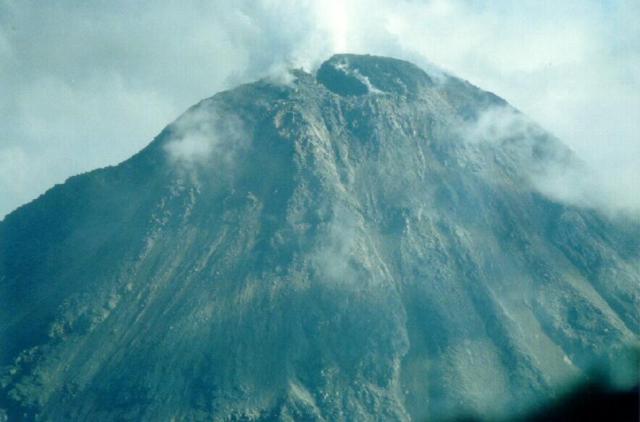 |
Figure 25. Photograph of Colima taken from the SW at 0930 on 21 November 1998. By this time the new dome has entirely filled the 1994 crater and was about to spill out onto the S face (on the right-central portion of the photo). Courtesy of J.C. Gavilanes, Universidad de Colima. |
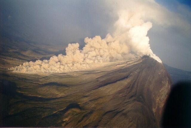 |
Figure 26. An oblique, wide-angle aerial photo taken with the camera somewhat tilted (note horizon in upper corner) showing a pyroclastic event at 0830 on 22 November 1998. The event left a series of block-and-ash flows reaching a maximum distance of 4.5 km W of the summit. Courtesy of Abel Cortés, Colima Volcano Observatory, Universidad de Colima. |
Another flight on 21 November revealed that the lava flow had advanced ~150 m downslope, and had a width of 100 m and a thickness of ~20 m. The lava flow continued advancing such that on 22 November it was 170 m long; on 23 November, 270 m; and on 24 November, 370 m. Block-and-ash flows emplaced during the morning of 25 November in the central branch of Barranca El Cordobán reached 1,900 m elevation. Observers and photographs revealed two additional lava flows as seen from both Rancho El Jabalí (10 km SW of the summit) during the night of 25 November and from Cofradia de Suchitlan (15 km SW) during the night of 26 November; these flows also descended the SW flank and headed towards two drainages (the W branch of Barranca El Cordobán and the S branch of Barranca La Lumbre).
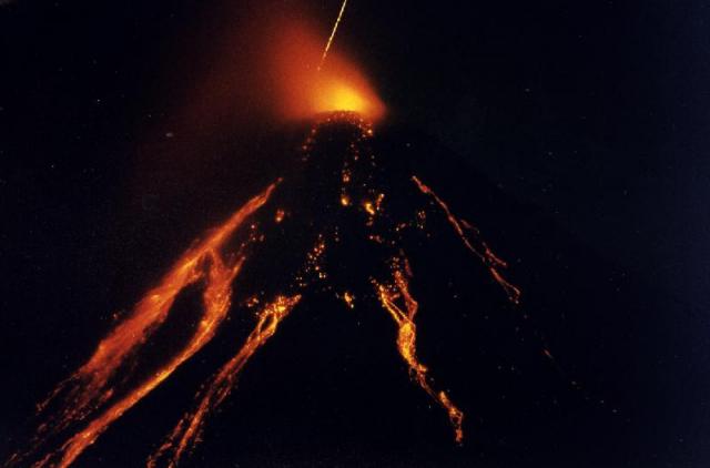 |
Figure 27. Time-lapse photograph (30 minutes) of Colima taken from a point near Suchitlan (15 km SW) around 2300 on 26 November 1998. Courtesy of Claus Siebe, UNAM. |
On 28 November, S. Rodríguez, J.M. Espíndola, and C. Siebe observed the advance of the westernmost lava flow from a 3,100-m-elevation vantage point. Most of the time the flow's front and margins relinquished large blocks (up to 10 m across) producing strong rumbling noises. Small block-and-ash flows moved quietly compared with the rockfalls from the lava flow. Still, it was possible to collect samples of the lava flow.
Viewed in thin section the new lava contained, in decreasing abundance, phenocrysts of zoned plagioclase, hypersthene, pleochroic resorbed brown hornblende, and subordinate magnetite in a microcrystalline to glassy matrix. Chemical analysis indicated that the new lava is very similar in composition to previous eruptions (table 5).
Table 5. Chemistry of freshly erupted Colima lava sampled on 28 November 1998. Courtesy of S. Rodríguez, J.M. Espíndola, and C. Siebe; analysis made by Rufino Lozano, Laboratorio de Fluorescencia de Rayos X at Instituto de Geología, UNAM.
| Element | Analysis |
| SiO2 | 59.14% |
| TiO2 | 0.66% |
| Al2O3 | 17.54% |
| Fe2O3 | 1.86% |
| FeO | 3.91% |
| MnO | 0.11% |
| MgO | 3.71% |
| CaO | 6.64% |
| Na2O | 3.99% |
| K2O | 1.31% |
| P2O5 | 0.16% |
| LOI | -0.02% |
| Total | 99.01% |
| Rb | 20 ppm |
| Sr | 549 ppm |
| Ba | 530 ppm |
| Y | 19 ppm |
| Zr | 148 ppm |
| Nb | 4 ppm |
| V | 110 ppm |
| Cr | 123 ppm |
| Co | 20 ppm |
| Ni | 32 ppm |
| Cu | 92 ppm |
| Zn | 68 ppm |
| Th | less than 2 ppm |
| Pb | 7 ppm |
On 2 December the three lava flows on the SSW flanks had reached these estimated lengths: 1,000 m (more westerly flow), 1,200 m (central flow), and 900 m (SE flow). Good views of these flows were obtained during an overflight the next day (figure 28). Around this time, it seemed most probable that the ongoing eruption would remain mostly effusive and not exceed the magnitude of eruptions witnessed here during past decades. Accordingly, inhabitants of La Yerbabuena were allowed to return to their homes on 1 December.
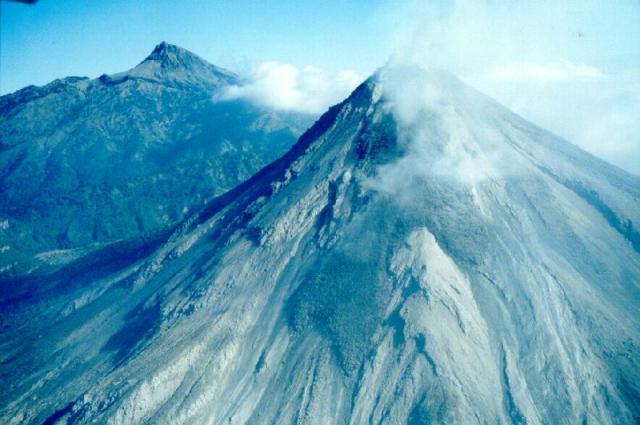 |
Figure 28. The state of lava flow advance on Colima at 0850 on 3 December 1998. Photograph taken from the SW by Juan Carlos Gavilanes. Courtesy of J.C. Gavilanes, Universidad de Colima. |
Fine ash produced thus far during the eruption consisted mostly of non-juvenile material related to rockfalls and small block-and-ash flows. Two stations, one located at Rancho El Jabalí (10 km SW of the summit) and the other at La Becerrera (12 km SW of the summit), registered maximum ashfalls on 23 and 26 November, respectively; both with daily loads of around 50 g/m2. The wind mostly dispersed this ash towards the SW and W.
COSPEC measurements carried out by Gavilanes and Cortes since 30 October 1998 showed a marked increase in SO2 flux (table 6). The highest discharge, measured on 26 November, yielded an estimate of more than 16,000 metric tons/day.
Table 6. COSPEC measurements for SO2 fluxes at Colima volcano at stated dates in 1998. Fluxes are in metric tons/day and were rounded to three significant figures. Measurements on 11 February, 14 April, 2 May, and 25 May were below the detection limit. Extrusion began on 20 November. Courtesy of Juan Carlos Gavilanes and Abel Cortes, Universidad de Colima and Colima Volcano Observatory.
| Date | Average | Maximum | Minimum | Uncertainty (±) | Avg. wind velocity (m/s) |
| 30 Oct 1998 | 408 | 437 | 365 | 36 | 6.01 |
| 14 Nov 1998 | 390 | 484 | 307 | 89 | 8.93 |
| 18 Nov 1998 | 1,610 | 2,270 | 905 | 685 | 7.20 |
| 21 Nov 1998 | 1,400 | 567 | 325 | 121 | 3.93 |
| 22 Nov 1998 | 850 | 1,110 | 647 | 229 | 1.30 |
| 24 Nov 1998 | 4,670 | 5,260 | 4,320 | 467 | 7.72 |
| 25 Nov 1998 | 8,210 | 9,250 | 7,260 | 994 | 7.29 |
| 26 Nov 1998 | 16,420 | 20,360 | 10,120 | 5,120 | 13.5 |
| 27 Nov 1998 | 10,670 | 13,150 | 7,930 | 2,610 | 15.2 |
| 28 Nov 1998 | 4,790 | 5,600 | 3,890 | 853 | 3.20 |
| 30 Nov 1998 | 2,330 | 2,500 | 2,070 | 216 | 5.81 |
| 03 Dec 1998 | 1,890 | 2,500 | 1,520 | 490 | 3.73 |
Geological Summary. The Colima complex is the most prominent volcanic center of the western Mexican Volcanic Belt. It consists of two southward-younging volcanoes, Nevado de Colima (the high point of the complex) on the north and the historically active Volcán de Colima at the south. A group of late-Pleistocene cinder cones is located on the floor of the Colima graben west and east of the complex. Volcán de Colima (also known as Volcán Fuego) is a youthful stratovolcano constructed within a 5-km-wide scarp, breached to the south, that has been the source of large debris avalanches. Major slope failures have occurred repeatedly from both the Nevado and Colima cones, producing thick debris-avalanche deposits on three sides of the complex. Frequent recorded eruptions date back to the 16th century. Occasional major explosive eruptions have destroyed the summit (most recently in 1913) and left a deep, steep-sided crater that was slowly refilled and then overtopped by lava dome growth.
Information Contacts: Juan Carlos Gavilanes, Carlos Navarro, Abel Cortés, Alicia Cuevas, and Esther Ceballos, Universidad de Colima; Claus Siebe, Juan Manuel Espíndola, Instituto de Geofísica, UNAM; Sergio Rodríguez-Elizarrarás, Instituto de Geología, UNAM.