Report on Colima (Mexico) — December 1998

Bulletin of the Global Volcanism Network, vol. 23, no. 12 (December 1998)
Managing Editor: Richard Wunderman.
Colima (Mexico) Lava continues descending the S flank during December 1998
Please cite this report as:
Global Volcanism Program, 1998. Report on Colima (Mexico) (Wunderman, R., ed.). Bulletin of the Global Volcanism Network, 23:12. Smithsonian Institution. https://doi.org/10.5479/si.GVP.BGVN199812-341040
Colima
Mexico
19.514°N, 103.62°W; summit elev. 3850 m
All times are local (unless otherwise noted)
This report is based primarily on official releases mainly covering December 1998. On 1 December three lava lobes existed, and the longest (central) about 800 m long and 350 m wide. Loose material traveled downslope 4.5 km. Monitored parameters indicated that the volcano was relatively stable, suggesting that neighboring communities were not at risk. On 1 December, the evacuation order was rescinded for the SW- flank community of Yerbabuena, 9 km from the summit. However, scientists reported increased activity on 9 December, when the longest flow reached 1.2 km from the summit. Summit winds changed at that time and began blowing ash away from villages.
By 10 December the central lobe had extended to ~1.7 km in length, and the E lobe reached a distance of ~1.3 km from the summit. In accord with these advances, the number of incandescent blocks escaping both near the summit and at the lava fronts increased. Figure 29 shows the three lava lobes on 11 December.
A press release on 14 December stated that during the previous 72 hours the volcano had generally remained at low intensity. The width of the central lava flow width remained at 350 m but in the following days the front crept forward to reach the following lengths: on 14 December; ~1.8 km; on 16 December, ~1.9 km; and on 4 January, ~2.9 km. The shorter, E lobe on 14-15 December had remained at ~1.35 km from the summit; on 16 December it reached 1.40 km. Blocks continued to break off and feed small avalanches but they remained within a 4.5-km radius.
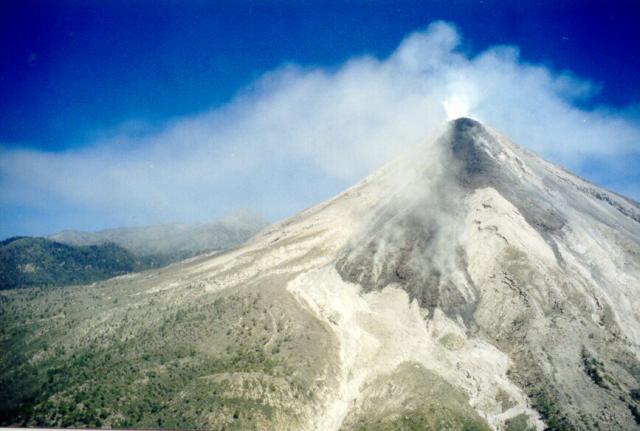 |
Figure 29. Fresh block lava flowing down Colima's upper slopes as seen from the air off the SW side on 11 December 1998. Volcan de Colima appears in the right foreground; the peak of Nevado de Colima can be seen in the left-central part of the photo obscured by haze. Lava flows followed incisions of the Cordoban drainage (barrancas). From left to right these headwaters comprise the Western, Central, and Eastern Cordoban. Photograph by Juan Carlos Gavilanes, Colima Volcano Observatory. |
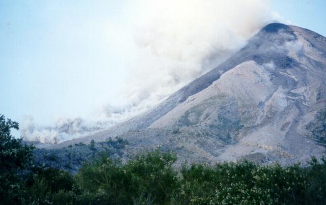 |
Figure 30. A block-and-ash flow seen at Colima on 11 December 1998 descending from the dome on the W side of Barranca Cordoban and beside one of the new lava flows. View is from a point at 2,150 m, 4.25 km S of the dome. Photograph by Juan Carlos Gavilanes, Colima Volcano Observatory. |
SO2 monitoring. A COSPEC flight on 31 December 1998 made five transects below the plume that resulted in an SO2 flux estimate of 4,930 ± 1,040 metric tons/day. An important component of a flux estimate comes from the wind velocity measurement, in this case computed by GPS. The average value was 4.7 m/s.
Satellite views. Peter Mouginis-Mark and over 10 other collaborators, colleagues, and co-workers have created a website displaying processed GOES 8 and GOES 10 satellite images of potential hot spots. Colima is one of eleven selected sites; each site gets imaged by a GOES satellite an average of once every 15 minutes.
Geological Summary. The Colima complex is the most prominent volcanic center of the western Mexican Volcanic Belt. It consists of two southward-younging volcanoes, Nevado de Colima (the high point of the complex) on the north and the historically active Volcán de Colima at the south. A group of late-Pleistocene cinder cones is located on the floor of the Colima graben west and east of the complex. Volcán de Colima (also known as Volcán Fuego) is a youthful stratovolcano constructed within a 5-km-wide scarp, breached to the south, that has been the source of large debris avalanches. Major slope failures have occurred repeatedly from both the Nevado and Colima cones, producing thick debris-avalanche deposits on three sides of the complex. Frequent recorded eruptions date back to the 16th century. Occasional major explosive eruptions have destroyed the summit (most recently in 1913) and left a deep, steep-sided crater that was slowly refilled and then overtopped by lava dome growth.
Information Contacts: Mauricio Breton Gonzalez; Carlos Navarro Ochoa, and Juan Carlos Gavilanes, Colima Volcano Observatory, Universidad de Colima, Ave. 25 de Julio 965, Colima 28045, Colima, México; Peter Mouginis-Mark, GOES Hotspot Monitoring System, Hawaii Institute of Geophysics and Planetology, University of Hawaii, 2525 Correa Road, Honolulu, Hawaii 96822 (URL: http://modis.higp.hawaii.edu/).