Report on Colima (Mexico) — January 1999

Bulletin of the Global Volcanism Network, vol. 24, no. 1 (January 1999)
Managing Editor: Richard Wunderman.
Colima (Mexico) Lava lobes continue to advance, explosion on 10 February ejects ash and ballistic blocks
Please cite this report as:
Global Volcanism Program, 1999. Report on Colima (Mexico) (Wunderman, R., ed.). Bulletin of the Global Volcanism Network, 24:1. Smithsonian Institution. https://doi.org/10.5479/si.GVP.BGVN199901-341040
Colima
Mexico
19.514°N, 103.62°W; summit elev. 3850 m
All times are local (unless otherwise noted)
Volcano Colima's three active block-lava lobes continued to slowly advance during January and February. The series of updates on the eruption written by Mauricio Bretón and issued through official channels on 5 and 19 January and 2 February indicated comparative quiet in terms of visible activity, monitored parameters, and the number and size of rockfalls. The updates now appear on the University of Colima Volcano Observatory website, where seismic data has also recently been plotted. Table 7 presents basic data for the lava lobes on 8 January.
Table 7. Some dimensions of advancing block lavas at Colima on 8 January 1999. Courtesy of Juan Carlos Gavilanes, Abel Cortes, and Carlos Navarro Ochoa.
| Drainage | Location of the front (m, elevation) | Length (m) | Maximum width (m) | Maximum thickness (m) |
| Western Cordoban | 2,400 | 2,800 | 250 | 20-30 |
| Central Cordoban | 2,390 | 3,100 | 250 | 20-30 |
| Eastern Cordoban | 2,560 | 2,500 | 250 | 20-30 |
A 7 February visit to the western and central fronts, in the headwaters of the Rio Cordoban, indicated that at ~2,180 m elevation these lobe fronts were only separated by a few meters of uncovered ground (figure 31). The visitors, included Mauricio Bretón, James Luhr, Carlos Navarro, and their guide Norberto Mendez from La Yerbabuena village. Although not visited, the flow front of the eastern lobe stood at 2,280 m elevation and continued to advance slowly, 5 m per day. The lava flow fronts were ~30 m high. Assuming an average thickness for the 1998-99 block lavas of 15 m, Navarro estimated the total erupted lava volume as 33 x 106 m3.
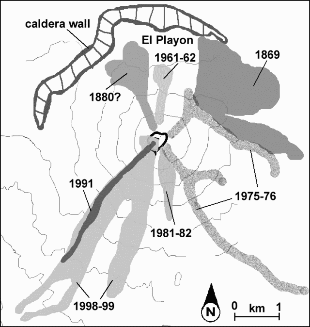 |
Figure 31. Sketch map of Volcan de Colima and vicinity showing block lava flows as late as 7 February 1999. The volcano is also locally known as "Fuego" and "Volcan de Fuego de Colima." Courtesy of Carlos Navarro. |
At 0900 on 8 February, Luhr and Navarro took photographs of the summit crater during a military helicopter flight (figures 32 and 33). They also saw a newly formed fissure cutting through the NE flank of the now deflated November 1998 dome. This fissure had nearly vertical walls that stood 5-10 m high and were encrusted with sulfur. Observers on the flight witnessed a small explosion that ejected gas with minor ash (figure 33). The plume rose within 20 seconds to an altitude of 1 km over the summit. The explosion was also recorded seismically, expressed as a low-frequency event.
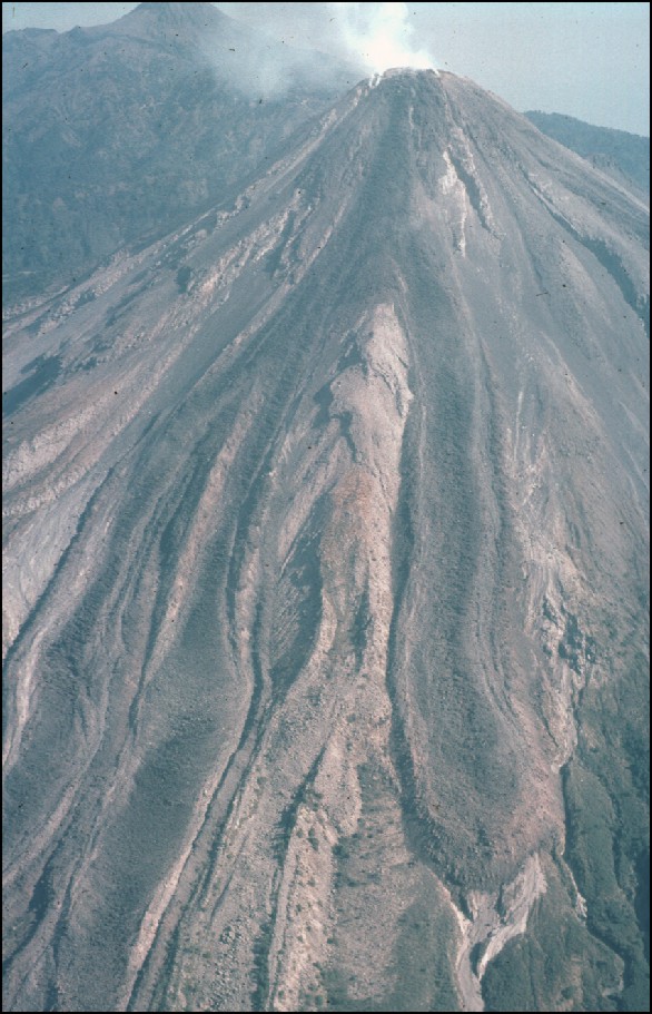 |
Figure 32. NNE-looking helicopter view of Colima volcano on 8 February 1999 showing the three active lava lobes bifurcating, two on the left (SW flank), and one breaking to the right (S flank) passing around a local high. Note that some of the prominent bounding levees surrounding the lava flows are actually from older lava flows. The 1991 lava flow has been completely covered by the new lava (see figure 31). Block and ash flows had also passed down these drainages both prior to and during lava emplacement. Photo courtesy of James Luhr. |
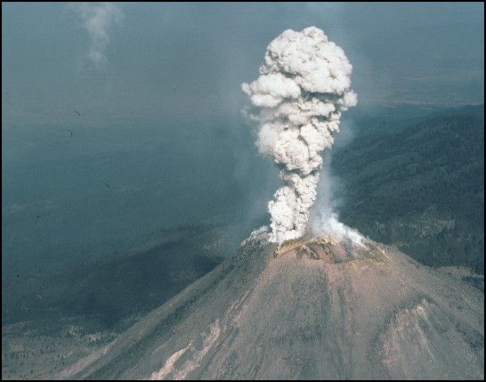 |
Figure 33. During the helicopter flight a small explosion took place at 1004 on 8 February; this shows the plume of gas and minor ash after it rose for ~5 seconds. Courtesy of James Luhr. |
At 0152 on 10 February a loud explosion ejected material from the E part of the November 1998 dome and parts of the adjacent summit weakened by hydrothermal alteration over the past 20 years. Strong seismicity was detected for less than an hour before the explosion, according to Gabriel Reyes of the Colima Seismic Network (RESCO). The 10 February explosion produced low-frequency signals allegedly 2.5 times larger than those associated with an explosion in July 1994, which destroyed the dome. Civil protection agencies reported that some residents were abruptly awakened by the explosion noise in the cities of Colima (32 km SSE of the volcano) and Guzman (25 km NE).
Another perspective on this explosion was provided by two members of the Jalisco State civil protection group who were sleeping in an observatory building at ~4,050 m elevation on Nevado de Colima, which forms the high point of the Colima volcanic complex, 5.8 km N of the active Volcan de Colima ("Fuego"). From the afternoon of 9 February these observers watched as vigorous fumaroles sent abundant gases above the volcano's summit. Then, at 1900 that day the fumarole's output decreased abruptly, seemingly halting until around the time of explosion about seven hours later. Less than 2 minutes after the explosion a column rose to 3-4 km forming a mushroom-shaped cloud. At the same time, incandescent blocks traveled down the N slope and others flew in high parabolic arcs 3.5-4 km from the vent. Some blocks started small forest fires in an area known as El Playón, between the N foot of the active cone and the caldera's northern rim (figure 31). Block-and-ash flows descended the San Antonio and Monte Grande river valleys and extended up to 3 km from the summit.
In the course of fieldwork, Luhr and Navarro had spent the night of 9-10 February at a small cabin on the N side of Nevado de Colima, 9 km N of the active volcano (the Jalisco State civil protection hut); they too were abruptly awakened by the explosion. Outside the cabin they saw a large column of ash and vapor illuminated in a rose color as it ascended rapidly behind Nevado de Colima's summit. The illuminated effect continued for up to 25 minutes with gradually decreasing intensity. Two dark plumes of ash bifurcated near the summit, obscuring the stars on this moonless and cloudless night. One of the plumes moved E and NE, droppin ash over the settlements including Tonila, San Marcos, La Cofradia, and Los Mazos. The other plume moved NW. Ashfall at the summit of Nevado de Colima lasted less than 3 hours. About 5 g of sample was collected. The ash consisted of fine angular fragments of plagioclase, pyroxenes, and occasional brown hornblende, and was interpreted to be non-juvenile, a result of explosive pulverization of the dome andesite. Some 3 hours after the explosion, Navarro observed brightly incandescent blocks descend the active cone into the NW part of El Playón, some of which started small forest fires.
Later, at about 1100 on 10 February from a point 5.8 km N of the volcano, Luhr and Navarro saw a gas column with minor ash rising 2.3 km above the volcano's summit and heard a sound like a jet turbine for up to 20 minutes. The sound reminded them of crater-generated noises heard when they visited the lava front on 7 February. Residents of La Yerbabuena had also heard similar sounds some days before these observers, as well as sporadic explosions that continued through 12 February. On clear nights around this time, observers saw incandescence coming from the crater.
On 11 February Gabriel Reyes of RESCO and Francisco Nuños Cornú and Carlos Suarez of the University of Guadalajara installed a 3-component seismic station in the Playón area. At distances up to 3-4 km from the summit they found numerous impact craters on the road. Fragmental blocks of 80-90 cm size formed craters up to 2 m in diameter; the craters' circular outlines suggested that the ballistic blocks descended nearly vertically. According to Suarez, ~80% of the sampled blocks consisted of fresh dome material, likely from the November 1998 dome.
Geological Summary. The Colima complex is the most prominent volcanic center of the western Mexican Volcanic Belt. It consists of two southward-younging volcanoes, Nevado de Colima (the high point of the complex) on the north and the historically active Volcán de Colima at the south. A group of late-Pleistocene cinder cones is located on the floor of the Colima graben west and east of the complex. Volcán de Colima (also known as Volcán Fuego) is a youthful stratovolcano constructed within a 5-km-wide scarp, breached to the south, that has been the source of large debris avalanches. Major slope failures have occurred repeatedly from both the Nevado and Colima cones, producing thick debris-avalanche deposits on three sides of the complex. Frequent recorded eruptions date back to the 16th century. Occasional major explosive eruptions have destroyed the summit (most recently in 1913) and left a deep, steep-sided crater that was slowly refilled and then overtopped by lava dome growth.
Information Contacts: Carlos Navarro Ochoa, Mauricio Bretón González, Juan Carlos Gavilanes, and Abel Cortes, Colima Volcano Observatory, Universidad de Colima, Ave. 25 de Julio 965, Colima 28045, Colima, México (URL: https://portal.ucol.mx/cueiv/); James Luhr, Smithsonian Institution, NMNH Department of Mineral Sciences, Washington, DC 20560-0119 USA; Gabriel Reyes, Universidad de Colima, Red Sismológica Telemétrica del Edo. de Colima (RESCO), Centro Univ. de Inv. En Ciencias Básicas, Ave. 25 de Julio, 965 Villa San Sebastián, Apdo. Postal 2-1694, Colima México; Francisco Nuñez-Cornú and Carlos Suarez-Plascencia, University of Guadalajara, Av. Universidad 203, Del Ixtapa, Puerto Vallarta, Jal., México.