Report on Santa Maria (Guatemala) — March 1999

Bulletin of the Global Volcanism Network, vol. 24, no. 3 (March 1999)
Managing Editor: Richard Wunderman.
Santa Maria (Guatemala) Explosions, lava flows, and lahars; summary of 1995-98 activity
Please cite this report as:
Global Volcanism Program, 1999. Report on Santa Maria (Guatemala) (Wunderman, R., ed.). Bulletin of the Global Volcanism Network, 24:3. Smithsonian Institution. https://doi.org/10.5479/si.GVP.BGVN199903-342030
Santa Maria
Guatemala
14.757°N, 91.552°W; summit elev. 3745 m
All times are local (unless otherwise noted)
Explosive activity and lava extrusion from the Caliente vent of the Santiaguito lava dome complex on the SW flank of Santa María continued in January 1999. Explosive activity in January was smaller (with plumes 150-500 m in height) following strong activity in November 1998 (see below). Recent plumes differed from typical explosive activity at Santiaguito; white-to-gray plumes, sometimes partially translucent, were denser and did not disperse rapidly, but draped the flanks of the dome. The lava flow extended ~500 m SW of the vent and had an oversteepened flow front, which periodically collapsed forming small pyroclastic flows and plumes 400-500 m high.
Summary of activity 1995-98. Frequent small-to-moderate explosive eruptions from Caliente vent accompanied by lava extrusion, periodic small pyroclastic flows, and lahars, took place throughout the 1990's. Lava extrusion down the ESE flank of Caliente that began in 1991 continued until 1995, gradually filling the barranco at the head waters of Río Nimá II (figure 28). In September 1995, the lava flow stopped after overtopping the barranca wall and spilling into the Río Nimá I drainage. From September 1995 until May 1996, lahars from the lava spillover traveled down the Río Nimá I, depositing fine sediments.
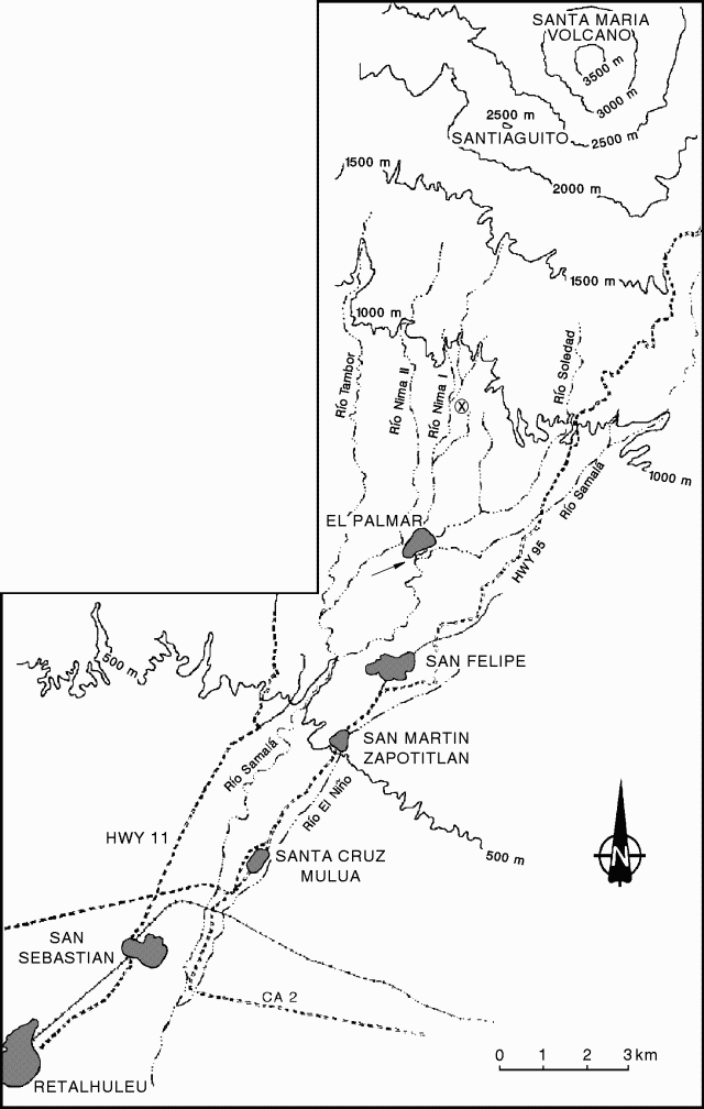 |
Figure 28. Sketch map of rivers and towns S of Santa María. Locations of drainages are approximate. Santiaguito Volcano Observatory is delineated by the circled "x" (~ 3 km N of El Palmar). The arrow below the abandoned town of El Palmar indicates where the Río Nimá I diverted into the Río Samalá. Courtesy of INSIVUMEH. |
Lava extrusion resumed in March 1996, shifting to an easterly direction. The first large lahar down the Río Nimá I took place on 17 May 1997. Lahars 5 m deep swept down the river, destroyed a bridge at Finca El Faro, and deposited 20-25 cm of sediment at the village of El Palmar, 10 km S of Santiaguito. Ten additional lahars took place from May to September 1997.
In 1998 continued lava extrusion into the Río Nimá I contributed to the generation of lahars downstream. From March to May 1998 the government dredged the river from 200 m above to 800 m below the bridge to protect the downstream towns of San Sebastian and Retalhuleu. The major highway was repeatedly overrun and then cleared.
On 28 May 1998, a large lahar descended the Río Nimá I and entered the N end of El Palmar, depositing 40 cm of fine sediment in the streets. The lahar was 7 m deep when it passed the Santiaguito Volcano Observatory, ~6 km S of Santiaguito. About 60 families were evacuated from El Palmar during the lahar, which was reported to be as loud as a jet engine; there were no fatalities. Following the May lahar the government declared El Palmar to be uninhabitable and the village was moved E across the Río Samalá.
From May to September an additional 12-15 lahars raised the river bed. From May to August, 5 m of hyperconcentrated-flow deposits were deposited in the Río Samalá above and below the town of San Felipe.
In August the largest lahar swept through the abandoned El Palmar, covering the S end of the town and destroying the cathedral, leaving only the front tower and the back wall standing. The lahar was 7 m deep and deposited about 2 m of sediment near the town hall. The Río Nimá I, which since 1991 had been diverted just south of town into the Río Samalá, shifted to a new course directly through the abandoned town. The lahar also produced major sedimentation downstream. Before May there had been 10 m of clearance below the Interamericana Pacifica highway bridge over the Río Samalá, 18 km from Santiaguito. After the August lahar there was only 1.5 m of clearance.
In November 1998 lahars down the Río Nimá I filled the channel above Finca La Mosquela, north of El Palmar, covering coffee plantations. There were, however, no major lahars resulting from Hurricane Mitch. The channel of the Río Nimá I, which in 1997 was ~12 m deep and 4-5 m wide at Finca Faro, below the Observatory, is now 15-20 m wide and 3-5 m deep. Farther downstream, between Finca La Mosquela and Finca Santa Marla, above El Palmar, the channel is only 1-3 m deep.
A strong effusive pulse began in November 1998, the first major magmatic event at Santiaguito since the explosions of 1989 and 1990. On 4 November a new lava flow began descending the SW flank of Caliente. Rapid effusion formed a cupola over the vent that collapsed repeatedly 8-20 November, producing pyroclastic flows in all directions, but principally SW. Pyroclastic flows traveled 4-5 km SW and S, and ash clouds rose 2 km. On 11-13 November collapses occurred at intervals of 15-60 minutes. Ashfall was reported in the towns of Retalhuleu and Coatepeque, where 2 mm of dark-gray ash accumulated.
Geological Summary. Symmetrical, forest-covered Santa María volcano is part of a chain of large stratovolcanoes that rise above the Pacific coastal plain of Guatemala. The sharp-topped, conical profile is cut on the SW flank by a 1.5-km-wide crater. The oval-shaped crater extends from just below the summit to the lower flank, and was formed during a catastrophic eruption in 1902. The renowned Plinian eruption of 1902 that devastated much of SW Guatemala followed a long repose period after construction of the large basaltic andesite stratovolcano. The massive dacitic Santiaguito lava-dome complex has been growing at the base of the 1902 crater since 1922. Compound dome growth at Santiaguito has occurred episodically from four vents, with activity progressing E towards the most recent, Caliente. Dome growth has been accompanied by almost continuous minor explosions, with periodic lava extrusion, larger explosions, pyroclastic flows, and lahars.
Information Contacts: Otoniel Matías, Instituto Nacional de Sismologia, Vulcanologia, Meteorologia e Hydrologia (INSIVUMEH), Ministerio de Communicaciones, Transporte y Obras Publicas, 7A Avenida 14-57, Zona 13, Guatemala City, Guatemala.