Report on Colima (Mexico) — April 1999

Bulletin of the Global Volcanism Network, vol. 24, no. 4 (April 1999)
Managing Editor: Richard Wunderman.
Colima (Mexico) Variable SO2 fluxes; 10 May explosion ascends to about 10 km altitude
Please cite this report as:
Global Volcanism Program, 1999. Report on Colima (Mexico) (Wunderman, R., ed.). Bulletin of the Global Volcanism Network, 24:4. Smithsonian Institution. https://doi.org/10.5479/si.GVP.BGVN199904-341040
Colima
Mexico
19.514°N, 103.62°W; summit elev. 3850 m
All times are local (unless otherwise noted)
A large explosion on 10 May was followed by intermittent explosions during 14-26 May. Variations in SO2 flux and morphological changes to the summit crater preceded the explosions.
SO2 flux data collected during 3 December 1998-15 May 1999 (table 10) showed that daily SO2-flux averages ranged between ~1,300 and 4,900 metric tons per day (t/d). In contrast, six days before the 10 May explosion researchers measured an anomalously low SO2 flux averaging ~350 t/d. Five days after the explosion a similarly low SO2 flux prevailed.
Table 10. Colima volcano's SO2 flux (in metric tons per day) from COSPEC measurements, 3 December 1998-15 May 1999. Data obtained by Colima Volcano Observatory staff members including J.C. Gavilanes and A. Cortés, with the collaboration of UNAM staff member Yuri Taran. In addition, on 3 and 22 February, the data were obtained by UNAM staff member Hugo Delgado. Courtesy of Juan Carlos Gavilanes, Colima Volcano Observatory.
| Date | Avg. | Max | Min | Uncert. (±) | Avg. wind velocity (m/s) | Traverse method |
| 03 Dec 1998 | 1,890 | 2,500 | 1,510 | 489 | 3.73 | Airborne |
| 07 Dec 1998 | 3,390 | 4,540 | 2,950 | 798 | 10.8 | Airborne |
| 09 Dec 1998 | 5,360 | 6,710 | 4,350 | 1,180 | 7.81 | Airborne |
| 11 Dec 1998 | 2,280 | 3,670 | 2,210 | 728 | 8.00 | Airborne |
| 31 Dec 1998 | 4,930 | 5,780 | 3,690 | 1,043 | 4.73 | Airborne |
| 03 Feb 1999 | 4,530 | 5,290 | 3,206 | 1,043 | 7.71 | Airborne |
| 14 Feb 1999 | 2,377 | 2,610 | 2,030 | 293 | 10.3 | Airborne |
| 17 Feb 1999 | 1,256 | 1,657 | 853 | 402 | 8.50 | Airborne |
| 20 Feb 1999 | 1,710 | 2,410 | 948 | 732 | 5.01 | Airborne |
| 22 Feb 1999 | 2,319 | -- | -- | 350 | -- | Airborne |
| 04 Mar 1999 | 4,764 | 5,408 | 4,087 | 661 | 15.1 | Airborne |
| 11 Mar 1999 | 2,760 | 3,642 | 2,184 | 729 | 15.2 | Airborne |
| 26 Mar 1999 | 1,432 | 2,030 | 943 | 543 | 8.6 | Ground |
| 31 Mar 1999 | 1,214 | 1,520 | 917 | 301 | 10.0 | Ground |
| 14 Apr 1999 | 1,044 | 1,406 | 674 | 366 | 7.7 | Ground |
| 04 May 1999 | 352 | 377 | 326 | 25 | 10.2 | Ground |
| 15 May 1999 | 406 | 483 | 361 | 61 | 5.1 | Airborne |
Shortly after the 10 February outburst (BGVN 24:02), views into the established summit crater disclosed that it held a small, centrally located inner crater, as well as some other small craters on its W side. All these small craters were attributed to explosions, such as those on 10 February, some others on 18 February, or other intense degassing events around that time. In the weeks after 10 February observers also saw concentric cracks becoming conspicuous in the summit area. Between 14 February and 11 March the summit crater became increasingly deep and fractured; however, despite these changes, the 1987 explosion crater still remained relatively intact on the dome's E side. Subsequent activity then declined until 10 May.
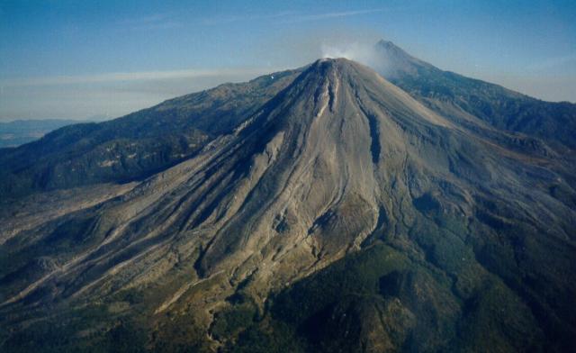 |
Figure 35. Broad overview of Colima's SW face on the exceptionally clear day of 11 March 1999. The photo captures recently erupted lava flows and their bounding levees. Courtesy of Juan Carlos Gavilanes, Colima Volcano Observatory, University of Colima. |
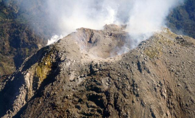 |
Figure 36. Oblique aerial view of Colima's summit crater as photographed on 11 March 1999. The viewer is looking at the mountain's SW side. Note the crescentic crack sets and fractures on the outer face and the lumpy, multiply cratered landscape within the summit crater. Courtesy of Juan Carlos Gavilanes, Colima Volcano Observatory, University of Colima. |
10 May explosion. At 1353 on 10 May an explosion was felt and heard in the city of Colima, 32 km SSE of the summit. At least 2 hours before the explosion, seismologist Gabriel Reyes (Red Sismológica Telemétrica del Edo. de Colima (RESCO), University of Colima) informed civil protection authorities about the increasing possibility of an explosive event within hours based on local seismicity. As a result, the civil protection officials provided warnings via telephone and radio to village leaders in La Yerbabuena and Juan Barragan. In the latter village, Jalisco civil protection officials initiated an evacuation of ~90 inhabitants. Meanwhile, at Yerbabuena (~192 inhabitants), the political representative of the village, Mr. Jesus Mendez, told residents to stay alert. Civil protection authorities of Colima recommended maximum alert without evacuation.
At the time of the eruption Observatory and RESCO staff were in their city of Colima offices. The accompanying photo (figure 37) was made ~45 seconds after they heard their windows rattle. Later, when the mushroom cloud appeared to cease rising, Carlos Navarro used a clinometer to estimate that its top reached ~6.5 km above the summit, an altitude of over 10 km.
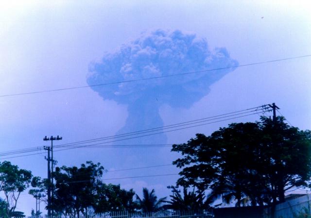 |
Figure 37. A photo of Colima's 10 May explosion, which produced a rapidly rising mushroom-shaped column. The photo was taken from the city of Colima (~ 32 km SSE of the volcano's summit) shortly after the explosion was first heard (see text). Courtesy of Juan Carlos Gavilanes, Colima Volcano Observatory, University of Colima. |
Eyewitnesses in La Yerbabuena (8 km SW of the summit) and Civil Protection authorities reported that the explosion was accompanied by small pyroclastic flows. The two largest pyroclastic flow mainly descended the SW flank where they entered into the Barrancas La Lumbre and Cordoban drainages. In a manner and scope very similar to the 10 February explosion, ballistic ejecta landed up to 4.5 km from the summit dome and caused local forest fires. Between 1930 and 2210 that day observers saw at least two much smaller exhalations of steam and ash without audible explosion noises. Authorities evacuated several villages.
14-26 May explosions. Two ash-bearing explosions took place on 14 May: one rose ~2.2 km above the summit; the other, ~1 km above the crater. In a 24-hour period around 17 May, there were about 20 explosive or degassing events, with ash falling on the edifice and incandescence coming from the summit dome. According to the Washington Volcanic Ash Advisory Center, by about 0800 that day the plume had reached 5 km altitude. Moreover, they described the plume as ~6 km wide, extending laterally for ~10 km, and traveling SW at 28 km/hour.
An Observatory press release on 19 May 1999 noted a 24-hour decrease in both the strength and the frequency of outbursts; however, at 0846 that morning an explosive eruption took place. On 24-25 May a large relative increase in seismicity occurred, including signals suggestive of degassing and explosions, but these decreased by 26 May.
Geological Summary. The Colima complex is the most prominent volcanic center of the western Mexican Volcanic Belt. It consists of two southward-younging volcanoes, Nevado de Colima (the high point of the complex) on the north and the historically active Volcán de Colima at the south. A group of late-Pleistocene cinder cones is located on the floor of the Colima graben west and east of the complex. Volcán de Colima (also known as Volcán Fuego) is a youthful stratovolcano constructed within a 5-km-wide scarp, breached to the south, that has been the source of large debris avalanches. Major slope failures have occurred repeatedly from both the Nevado and Colima cones, producing thick debris-avalanche deposits on three sides of the complex. Frequent recorded eruptions date back to the 16th century. Occasional major explosive eruptions have destroyed the summit (most recently in 1913) and left a deep, steep-sided crater that was slowly refilled and then overtopped by lava dome growth.
Information Contacts: Colima Volcano Observatory, University of Colima, Ave. 25 de Julio 965, Colima 28045 México (URL: https://portal.ucol.mx/cueiv/); Washington Volcanic Ash Advisory Center (VAAC), NOAA/NESDIS Satellite Analysis Branch, Room 401, 5200 Auth Road, Camp Springs, MD 20746, USA (URL: http://www.ospo.noaa.gov/Products/atmosphere/vaac/); Gabriel Reyes, Red Sismológica Telemétrica del Edo. de Colima (RESCO), Centro Univ. de Inv. En Ciencias Básicas, Universidad de Colima, Ave. 25 de Julio, 965 Villa San Sebastián, Apdo. Postal 2-1694, Colima, México.