Report on Batur (Indonesia) — June 1999
Bulletin of the Global Volcanism Network, vol. 24, no. 6 (June 1999)
Managing Editor: Richard Wunderman.
Batur (Indonesia) New eruption beginning in March; frequent explosions
Please cite this report as:
Global Volcanism Program, 1999. Report on Batur (Indonesia) (Wunderman, R., ed.). Bulletin of the Global Volcanism Network, 24:6. Smithsonian Institution. https://doi.org/10.5479/si.GVP.BGVN199906-264010
Batur
Indonesia
8.2403°S, 115.3775°E; summit elev. 1711 m
All times are local (unless otherwise noted)
During the week of 9-15 March, white ash plumes rose 10-100 m above the crater. Booming noises were heard six times, and volcanic earthquakes increased drastically compared to the previous week (table 1). It was later determined that an ash eruption had begun on 15 March, sending bluish-white plumes 10-50 m high. On 17 March, two relatively recent craters merged when a connecting ridge collapsed as a result of earthquakes and small eruptions.
Table 1. Weekly seismicity recorded at Batur, March-July 1999. Types of events include volcanic A-type, volcanic B-type, tectonic, explosion earthquakes, and ash emissions (small explosion earthquakes). No data were available for the period 30 March-19 April. Maximum explosion amplitudes were reported as 2-26 mm during May; more typical, smaller amplitudes were 1.5-24 mm during May-July. Courtesy of VSI.
| Date | A-type | B-type | Tectonic | Explosion | Emission |
| 02-08 Mar 1999 | 2 | 0 | 1 | 0 | 2 |
| 09-15 Mar 1999 | 106 | 241 | 1 | 0 | 26 |
| 16-22 Mar 1999 | 0 | 14 | 1 | 270 | 5 |
| 23-29 Mar 1999 | -- | -- | 1 | 299 | -- |
| 30 Mar-05 Apr 1999 | -- | -- | -- | -- | -- |
| 06-12 Apr 1999 | -- | -- | -- | -- | -- |
| 13-19 Apr 1999 | -- | -- | -- | -- | -- |
| 20-26 Apr 1999 | 1 | 2 | 2 | 79 | 35 |
| 27 Apr-03 May 1999 | 0 | 0 | 0 | 42 | 21 |
| 04-10 May 1999 | 0 | 0 | 0 | 26 | 39 |
| 11-17 May 1999 | 8 | 3 | 6 | 68 | 21 |
| 18-24 May 1999 | 0 | 0 | 3 | 337 | 47 |
| 25-31 May 1999 | 1 | 6 | 0 | 112 | 31 |
| 01-07 Jun 1999 | 3 | 4 | 1 | 6 | 19 |
| 08-14 Jun 1999 | 12 | 5 | 4 | 0 | 52 |
| 15-21 Jun 1999 | 4 | 6 | 4 | 85 | 48 |
| 22-28 Jun 1999 | 5 | 13 | 1 | 141 | 31 |
| 29 Jun-05 Jul 1999 | 10 | 10 | 2 | 171 | 50 |
| 06-12 Jul 1999 | 1 | 6 | 1 | 122 | 32 |
| 13-19 Jul 1999 | 0 | 0 | 1 | 206 | 14 |
Volcanic activity was dominated by emission events (small explosions) during the week of 23-29 March; the eruption plume was white-blue in color, rising 10-100 m above crater rim. Booming noises were heard three times on 22 March, but no glow was observed. Reports are not available for most of April, but during late April through the middle of May the seismic record was dominated by explosion events. Ash plumes, described as "white" or "white-bluish" were observed rising 50-100 m above the crater. Neither explosion sounds nor glow was observed.
Six explosions on 17 May ejected materials that fell around the crater. Another explosion on 25 May was accompanied by incandescent ejections that fell around the crater. Explosion sounds were heard on 17 occasions during the week of 25-31 May. "White ash emissions" rose only to 25 m during 1-14 June, but varied between 10 and 100 m the rest of the month. Similar activity continued through mid-July, and a variable rumbling noise was heard the week of 13-19 July.
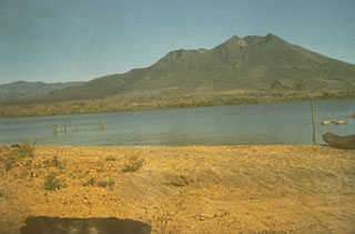
Geological Summary. The historically active Batur is located at the center of two concentric calderas NW of Agung volcano. The outer 10 x 13.5 km caldera was formed during eruption of the Bali (or Ubud) Ignimbrite about 29,300 years ago and now contains a caldera lake on its SE side, opposite the Gunung Abang cone, the topographic high of the complex. The inner 6.4 x 9.4 km caldera was formed about 20,150 years ago during eruption of the Gunungkawi Ignimbrite. The SE wall of the inner caldera lies beneath Lake Batur; Batur cone has been constructed within the inner caldera to a height above the outer caldera rim. The Batur stratovolcano has produced vents over much of the inner caldera, but a NE-SW fissure system has localized the Batur I, II, and III craters along the summit ridge. Recorded eruptions have been characterized by mild-to-moderate explosive activity sometimes accompanied by lava emission. Basaltic lava flows from both summit and flank vents have reached the caldera floor and the shores of Lake Batur in historical time.
Information Contacts: Volcanological Survey of Indonesia (VSI), Jalan Diponegoro No. 57, Bandung 40122, Indonesia (URL: http://www.vsi.esdm.go.id/).