Report on Lopevi (Vanuatu) — July 1999

Bulletin of the Global Volcanism Network, vol. 24, no. 7 (July 1999)
Managing Editor: Richard Wunderman.
Lopevi (Vanuatu) Intracrater vent emits December 1998 lava flow; 1999 ash emissions
Please cite this report as:
Global Volcanism Program, 1999. Report on Lopevi (Vanuatu) (Wunderman, R., ed.). Bulletin of the Global Volcanism Network, 24:7. Smithsonian Institution. https://doi.org/10.5479/si.GVP.BGVN199907-257050
Lopevi
Vanuatu
16.507°S, 168.346°E; summit elev. 1413 m
All times are local (unless otherwise noted)
Sporadic eruptive activity at Lopevi volcano occurring since July 1998 has consisted of intermittent Strombolian explosions confined to a NW-flank crater at ~1,000 m altitude. Lava extrusion in December 1998 produced a small intracrater flow (figure 3). The flow originated from a ~20-m-high cone ("A" on figure 3) at the NW end of the main 1963 crater. The cone itself contained a small but prominent steep-walled crater (figures 4 and 5).
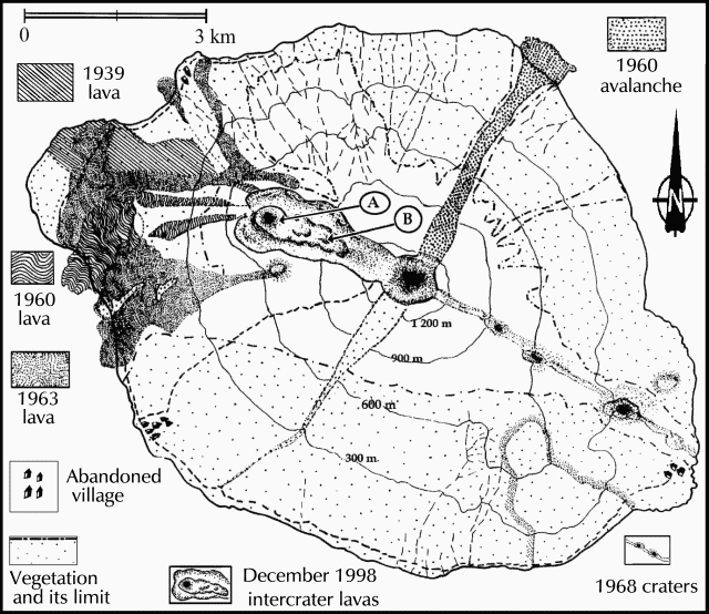 |
Figure 3. Sketch map of Lopevi showing lavas of 1939-1998. Areas "A" and "B" refer to photos shown as figures 3 and 4. Produced from an original map by A-J. Warden including observations by A-J. Warden and R. Priam (Archive Service de Mines); revised and updated by D. Charley and M. Lardy and drafted by A. Mabonlala, IRD. |
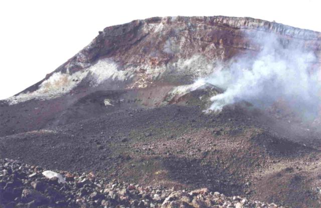 |
Figure 4. The intracrater cone of Lopevi (labeled "A" on the sketch map, figure 3) is seen looking NNW on 19 March 1999 with the fresh 1998 aa lava flow in the center and right foreground. The wall of the 1963 crater appears in the background. Photo courtesy of IRD and M. Lardy. |
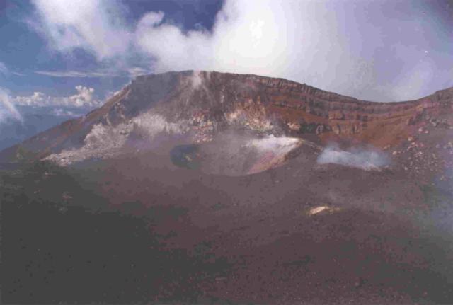 |
Figure 5. The intracrater cone of Lopevi (labeled "A" on the sketch map, figure 3) is seen looking NNW on 19 March 1999. The wall of the 1963 crater appears in the background. Photo courtesy of IRD and M. Lardy. |
During a March 1999 visit scientists examined the intracrater flow (figure 6), which had a volume of ~6,000 m3. The lower (eastern end) of the flow is labeled "B" on the map (figure 3). The intracrater flow contained abundant lava blocks with aa texture and a cover of explosion debris. Meter-sized blocks originating from a relatively viscous magma had been rafted to the flow front.
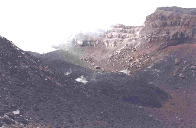 |
Figure 6. The 1998 Lopevi intracrater lava flow (looking NW from point "B" on figure 3) forms the dark-colored area extending diagonally across the 1963 crater floor. The ejecta-covered flow, ~100 m long and 10 m wide, traveled from left to right from the small cone seen steaming at the upper left. Photo courtesy of IRD and M. Lardy. |
Following initially more rapid movement, the lava slowed to advance at daily rates of a few to a dozen meters. Minor Vulcanian eruptions accompanied the flow. Constant fumarolic activity along with periodic small explosion plumes continued since January 1999. From 2 August 1999 scientists observed eruption plumes that rose to about 1 km altitude associated with the ejection of bombs from the crater.
Geological Summary. The small 7-km-wide conical island of Lopevi, known locally as Vanei Vollohulu, is one of Vanuatu's most active volcanoes. A small summit crater containing a cinder cone is breached to the NW and tops an older cone that is rimmed by the remnant of a larger crater. The basaltic-to-andesitic volcano has been active during historical time at both summit and flank vents, primarily along a NW-SE-trending fissure that cuts across the island, producing moderate explosive eruptions and lava flows that reached the coast. Historical eruptions at the 1413-m-high volcano date back to the mid-19th century. The island was evacuated following major eruptions in 1939 and 1960. The latter eruption, from a NW-flank fissure vent, produced a pyroclastic flow that swept to the sea and a lava flow that formed a new peninsula on the western coast.
Information Contacts: Sandrine Wallez and Michel Lardy, Institut de Recherche pour la Développment (IRD), BP 76, Port Vila, Vanuatu; Claude Robin, OPGC, 5 rue Kessler, 63000 Clermont-Ferrand, France; Charley Douglas, Vanuatu Department of Geology, Mines and Water Resources, PMB 01, Port Vila, Vanuatu.