Report on Cameroon (Cameroon) — September 1999
Bulletin of the Global Volcanism Network, vol. 24, no. 9 (September 1999)
Managing Editor: Richard Wunderman.
Cameroon (Cameroon) Tremor after March-April eruption; felt seismic events in early October
Please cite this report as:
Global Volcanism Program, 1999. Report on Cameroon (Cameroon) (Wunderman, R., ed.). Bulletin of the Global Volcanism Network, 24:9. Smithsonian Institution. https://doi.org/10.5479/si.GVP.BGVN199909-224010
Cameroon
Cameroon
4.203°N, 9.17°E; summit elev. 4095 m
All times are local (unless otherwise noted)
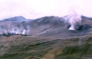
The eruption from the S flank of Mt. Cameroon that began on 28 March was followed by the opening of a second set of fissures opening on 30 March, sending a voluminous aa flow towards the ocean that continued throughout the first two weeks of April (BGVN 24:03 and 24:04). On 11 April the flow front was 150-200 m wide and 30 m thick and progressing at a rate of several m/hour; lava production ended on 14 April. A notice on 5 June from Henri Hogbe Nlend, the Minister of Scientific and Technical Research (Ministre de la Recherche Scientifique et Technique, MINREST), said abnormal and repeated high-amplitude seismic events were recorded on the night of 30 May by seismographs in Ekona. This was the first time since the end of the eruption that such events have been registered.
On July 11 the head of the Scientific Committee monitoring Mt. Cameroon, Samuel Ayongue, was quoted in The Post, a weekly newspaper, as being "...worried about the tremors going on now because they have increased in intensity and frequency." According to Ayongue, the tremors were being caused by magma refilling spaces created during the eruption. It was difficult to locate the earthquakes because of inadequate seismic equipment.
The Assistant Director of the Institute for Mining and Geological Research (IRGM) at Ekona, Richard Ubangoh, disclosed on 13 October that during 4-6 October, 54 seismic events ("earth tremors") were recorded. A notice to the Minister of Scientific and Technical Research confirmed earlier reports of frequent felt earthquakes by residents living on the foot of Mt. Cameroon. A source at MINREST, quoting the notice for Isaha'a Boh, stated that the events "... were not serious [enough] to cause any damage or immediate threat." The Assistant Director regretted that "... the equipment in use presently, are quite old and cannot provide reliable results." While waiting for 10 new seismographs from Europe in the next six months Ubangoh stated that provisional equipment would be installed at the foot of the mountain in the next three months.
Geological Summary. Mount Cameroon, one of Africa's largest volcanoes, rises above the coast of west Cameroon. The massive steep-sided volcano of dominantly basaltic-to-trachybasaltic composition forms a volcanic horst constructed above a basement of Precambrian metamorphic rocks covered with Cretaceous to Quaternary sediments. More than 100 small cinder cones, often fissure-controlled parallel to the long axis of the 1400 km3 edifice, occur on the flanks and surrounding lowlands. A large satellitic peak, Etinde (also known as Little Cameroon), is located on the S flank near the coast. Historical activity was first observed in the 5th century BCE by the Carthaginian navigator Hannon. During historical time, moderate explosive and effusive eruptions have occurred from both summit and flank vents. A 1922 SW-flank eruption produced a lava flow that reached the Atlantic coast, and a lava flow from a 1999 south-flank eruption stopped only 200 m from the sea. Explosive activity from two vents on the upper SE flank was reported in May 2000.
Information Contacts: Isaha'a Boh Cameroon, Media Research and Strengthening Institute, P.O. Box 731, Yaounde, Cameroon.