Report on Additional Reports (Unknown) — December 1999

Bulletin of the Global Volcanism Network, vol. 24, no. 12 (December 1999)
Managing Editor: Richard Wunderman.
Additional Reports (Unknown) Japan: Spectra of hydrophone-detected tremor
Please cite this report as:
Global Volcanism Program, 1999. Report on Additional Reports (Unknown) (Wunderman, R., ed.). Bulletin of the Global Volcanism Network, 24:12. Smithsonian Institution. https://doi.org/10.5479/si.GVP.BGVN199912-600500
Additional Reports
Unknown
Lat Unknown, Unknown; summit elev. m
All times are local (unless otherwise noted)
Robert Dziak at the NOAA/Pacific Marine Environmental Laboratory noted that loud acoustic signals continue to be detected from an unknown submarine source in or adjacent to the Volcano Islands of Japan (see sketch map in BGVN 24:11). Spectra and representative time series appear in figures 2, 3, and 4. These data were collected near the Galapagos Islands by a NOAA hydrophone (at 8°S, 95°W) roughly 14,000 km from the estimated source.
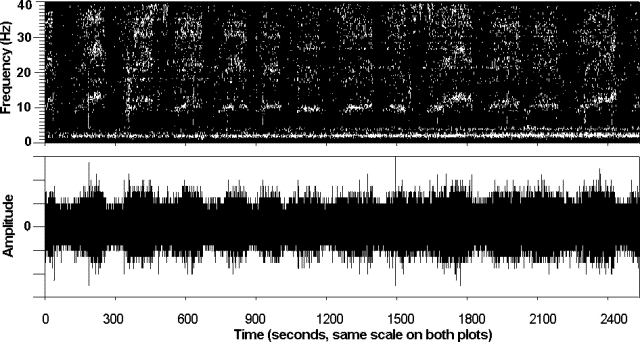 |
Figure 2. Hydrophone record showing the acoustic signals detected from an inferred submarine eruption along the Bonin arc. At this time, the exact location of the volcano is uncertain. The diagram shows a ~ 2,500-second interval of the time-series amplitude (bottom) and corresponding frequency spectra (from consecutive 1-second data windows) received on a hydrophone at 10°S, 95°W. The tremor signals typically last 2-5 minutes; they display a 10 Hz fundamental with 20, 30, and 40 Hz overtones. The signals were recorded on 21 March 1999 (2100-22:00 GMT), after propagating across the Pacific through the oceanic-sound (SOFAR) channel. Similar signals were detected at hydrophone arrays in the E and NE Pacific and at remote hydrophones maintained by NOAA located near the Galapagos Islands. Courtesy of R. Dziak. |
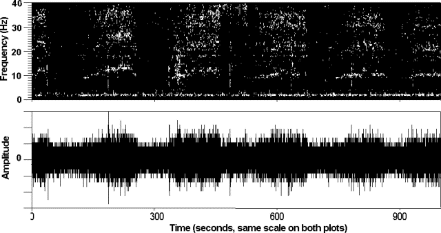 |
Figure 3. This diagram shows an enlargement of the hydrophone record at 10°S, 95°W from an inferred submarine eruption along the Bonin arc. The diagram shows a ~1,000-second interval of the time-series amplitude (bottom) and the corresponding frequency spectra (top). For this interval, only the 20- and 30-Hz overtones are readily apparent (above). The signals shown arrived at the hydrophone at 2100-2200 GMT on 21 March 1999. Courtesy of R. Dziak. |
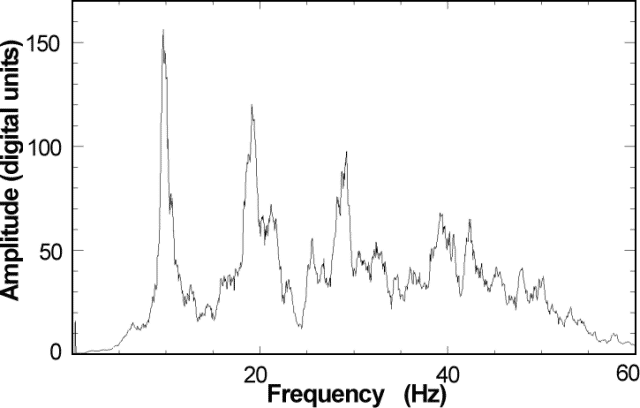 |
Figure 4. A spectral plot of hydrophone amplitude versus frequency from an unconfirmed submarine eruption along the Bonin arc. The spectra were produced from one of the 2-minute signal packets shown in figures 3 and 4. The plot shows a fundamental frequency centered near 10 Hz, and lower-amplitude harmonics at 20, 30, and 40 Hz. Courtesy of R. Dziak. |
The extremely high-amplitude tremor signals have been detected since May 1998, and are clearly recorded on hydrophone arrays in the N and E Pacific, and at a NOAA array in the equatorial area near the Galapagos Islands. The signals are larger, for example, than those from the 1993 submarine eruption at Soccoro Island (BGVN 18:01), and consist of a high-amplitude 10-Hz fundamental and three harmonics at 20, 30, and 40 Hz . The signals are unlikely to have come from any easily envisioned synthetic or biological sources (such as whales) because the fundamental wavelengths are substantial, seemingly too long to have been generated by these types of sources.
In general, the hydrophones are deployed within the ocean-sound (SOFAR) channel. The sound channel is a region of low acoustic velocity, and therefore acts much like a waveguide, allowing sound waves in the ocean to propagate over long distances with little loss in signal strength. However, the signal can be small or even absent at some stations due to bathymetry shadowing or other effects.
According to Olivier Hyvernaud, after careful comparison with the hydroacoustical data, the signals were recognized in seismic records at Tahiti, where the French Polynesian Network commonly records the converted seismic waves of ocean-acoustic signals that propagate past the islands. However, the signals have not been recognized on seismic instruments at Iwo Jima. Although it may seem surprising that Iwo Jima would lack a signal, Dziak notes that the difference could be explained by the physics of the situation. Acoustic waves propagating through an ocean-sound channel (2-D) would undergo little attenuation. In contrast, the seismic waves propagating through the Earth's crust (3-D) undergo much greater attenuation with distance. The Bulletin continues to present hydro-acoustical data so that others may compare them with records from local instruments.
The inferred source area of these acoustic signals (see BGVN 24:11) was derived by combining the arrival times of correlated signals throughout the Pacific basin with detailed ocean sound-speed models. Ocean sound-speed is a complex function of temperature, salinity, and pressure (depth). The models are a result of 30 years of direct sampling of these ocean parameters and account for seasonal variations. Unfortunately, the source of these signals is well to the W of the hydrophone arrays; consequently, the source location is not well-constrained. The estimated source area comprises over ~1.4 x 10⁵ km2, and the area of uncertainty (the "box" shown on the sketch map) could extend far enough east to include the known active volcanic areas such as the Bonin arc. It is hoped that as more ancillary information becomes available, it will be possible to derive a better estimate of the source location.
On the topic of volcanism along the volcanic front of the Bonin arc, Yasuo Otani of the Japanese Maritime Safety Agency noted that there are daily commercial air flights to Guam (~1,300 km S of Iwo jima).
Otani conveyed the latest observations at the two known active vents near Iwo Jima. At Fukutoku-okanoba on 25 January observers saw very small changes in water color; on 26 January they noted somewhat larger-scale changes. Around the same time, 25-26 January, Funka-asane was also the scene of discolored water.
Both Fukutoku-okanoba and Funka-asane are sufficiently shallow that the vent's flux changes can be easily seen from the surface. In fact, hydrothermal emanations and small-scale eruptions gain much attention from fishermen, who keep an eye on various local eruptive sites because they believe some eruptive phases affect fishing.
Otani expressed doubt of far-traveled geophysical signals from either of these two sources near Iwo jima. Instead, he noted, enormous acoustical noise must eminate from breakwater construction on the margin of the Bonin Islands (Ogasawara Islands), ~200 km NE of Iwo Jima, where a large-scale blasting and other heavy moving has been occurring.
Geological Summary. Reports of floating pumice from an unknown source, hydroacoustic signals, or possible eruption plumes seen in satellite imagery.
Information Contacts: Robert P. Dziak, Oregon State University/NOAA, Hatfield Marine Science Center, 2115 SE OSU Drive, Newport, OR 97365 USA (URL: http://newport.pmel.noaa.gov/); Yasuo Otani, Coastal Surveys and Cartography Division, Hydrographic Department, Maritime Safety Agency, 3-1 Tsukiji, 5-Chome, Chuo-ku, Tokyo 104-0045, Japan.