Report on Lopevi (Vanuatu) — April 2000

Bulletin of the Global Volcanism Network, vol. 25, no. 4 (April 2000)
Managing Editor: Richard Wunderman.
Lopevi (Vanuatu) Intermittent ash eruptions October 1999-April 2000; pyroclastic flow in February
Please cite this report as:
Global Volcanism Program, 2000. Report on Lopevi (Vanuatu) (Wunderman, R., ed.). Bulletin of the Global Volcanism Network, 25:4. Smithsonian Institution. https://doi.org/10.5479/si.GVP.BGVN200004-257050
Lopevi
Vanuatu
16.507°S, 168.346°E; summit elev. 1413 m
All times are local (unless otherwise noted)
Intermittent activity in October and December 1999 and February-March 2000 was reported by pilots flying near the island. Reports sent to the Wellington Volcanic Ash Advisory Center and the Port Vila control tower resulted in aviation advisories that formed the basis for this summary. Additional information about February activity was provided by John Seach, who visited the volcano (figure 7) during 23-24 February and talked to local residents.
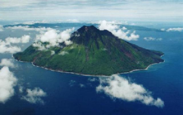 |
Figure 7. Photograph of Lopevi volcano with Epi Island in the distance, February 2000. Courtesy of John Seach. |
During 1963-82, ash emissions, lava flows, lava fountains, and Strombolian explosions occurred intermittently. This twenty-year pattern ended on 24 October 1982. Eruptive activity resumed in July 1998. A series of Strombolian explosions in the main 1963 crater (just NW of the central crater) was observed during November-December 1998 (BGVN 24:02). Lava extrusion in December 1998 produced a small intracrater flow from a cone at the NW end of the 1963 crater (BGVN 24:07). Sporadic eruptive activity observed between the end of December 1998 and March 1999 was confined to the 1963 crater at ~1,000 m elevation on the NW flank.
Ground observers reported on 15 October 1999 that a minor eruption approximately one week earlier consisted of a continuous ash plume rising to an altitude of 300-600 m. An ash cloud up to 2,700 m altitude was reported by pilots on 9-10 December.
Activity during February 2000. At 1422 on 3 February an ash cloud was reported up to 4,500 m over the island. Between 0507 and 0520 on 18 February a Vanair pilot reported an ash cloud initially as high as 9 km and then around 4.8 km altitude. A plume was identified on infrared and early morning visible satellite imagery, but there was considerable cloudiness in the area. Activity was continuing as of 0602 on 19 February, with an ash plume to ~5.5 km altitude. Convective activity through the day rapidly obscured any traces of the ash plume on satellite imagery. Analyses indicated that the plume may have contained significant ash that was expected to move ESE-SE and extend to 370 km. Due to the convective activity pilots were advised to respond as though the plume was rising to ~9 km altitude. However, another pilot report at 0621 indicated that activity had ceased.
According to John Seach, around midday on 19 February villagers on the neighboring island of Paama heard two loud explosions from the volcano; the second was the loudest heard in two years. This was followed by a brown ash cloud rising to ~4.5 km altitude visible from an aircraft en route from Sydney to Hawaii. Ashfalls occurred on Paama. A pyroclastic flow from the NW-flank crater (figure 8) traveled 2.5 km SW and reached the sea along a 300-m-wide front, where it created a delta. Blocks of 4 m in diameter were carried down to sea level. A 3-m-diameter block 50 m from the sea had a surface temperature of 170°C.
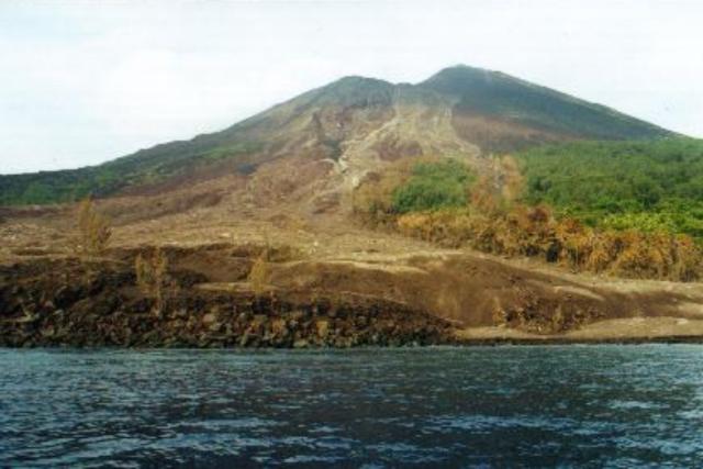 |
Figure 8. View of the 19 February pyroclastic flow path from summit of Lopevi to the sea, 23 February 2000. Courtesy of John Seach. |
Trees buried in the ash were only visible as circular, black smoking areas when observed on 23 February. On the edge of the pyroclastic-flow deposit trees 0.5 m in diameter were snapped off 2 m from the ground (figure 9); some were upturned and redeposited in the ash. Standing devastated trees were burnt to a height of 18 m and debris was lodged in the canopy. Some fallen trees were still burning. Within 20 m of the edge of the pyroclastic-flow deposit were fallen devastated trees, and standing burnt trees were present for another 10 m beyond that. Observers were forced back when ground temperatures (over 200°C) melted boots. The air was filled with the smell of burnt trees and sulfur. Coconuts superheated and exploded. Sap in smaller branches boiled and formed bubbles on the outside of the branch.
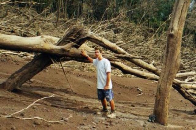 |
Figure 9. Devastated trees at the edge of a pyroclastic flow from Lopevi, 23 February 2000. Courtesy of John Seach. |
The active NW crater (figure 10) was climbed by Seach and Geoff Mackley on 23 and 24 February 2000. A lava dome was present on the SW crater rim from where the pyroclastic flow had originated along a 100-m-wide front. Lighter colored deposits marked its track down the volcano. On the N edge of the pyroclastic-flow deposit and 200 m below the NW crater was the source of a debris avalanche. A debris volume on the order of a million cubic meters had moved, exposing a large hole and producing two branching flows that moved ~250 m SW towards the sea. A new 150-m-high cinder cone formed inside the old crater was smoking with blue and white vapor being emitted. Ground temperature was 81°C at the base of the cinder cone. A two-week-old flank lava flow was observed to have traveled 1.5 km WNW to an elevation 250 m below the NW crater, burning trees and vegetation.
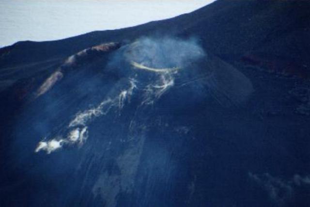 |
Figure 10. Aerial view of the active NW crater at Lopevi, February 2000. Courtesy of John Seach. |
Additional eruptions during March and April 2000. Another minor eruption on 15 March sent ash to 1,500 m, where it mixed with meteorological clouds. A stronger eruption began on 21 March with ash reported to 2,700 m altitude along with steam to 450 m. Activity increased the next day, when the plume was reported to be at levels of 4,200-4,500 m. The eruption continued during 23-24 March with plumes rising to altitudes of about 2,400 m.
A pilot report around 1100 on 24 April indicated a very dark-brown ash cloud rising from the volcano to an altitude of ~4,800 m and drifting NW. The report also noted that a new vent on the W side was emitting lava. A notice to aviators stated that they should expect ash to 5,400 m altitude within 550 km in the NW quadrant of the volcano. Ash warnings to aviators in the late morning and night of 25 April indicated that ash and lava continued to be emitted from the W vent. Pilot reports indicated that the height of the ash cloud was difficult to determine due to cloud cover, but was at least to 600 m altitude. The ash appeared to be thinning out beyond 18 km W of the volcano, but the extent of the plume could not be determined from satellite imagery. A notice at 2155 on 26 April stated that no further visual activity reports had been received since 25 April.
Geological Summary. The small 7-km-wide conical island of Lopevi, known locally as Vanei Vollohulu, is one of Vanuatu's most active volcanoes. A small summit crater containing a cinder cone is breached to the NW and tops an older cone that is rimmed by the remnant of a larger crater. The basaltic-to-andesitic volcano has been active during historical time at both summit and flank vents, primarily along a NW-SE-trending fissure that cuts across the island, producing moderate explosive eruptions and lava flows that reached the coast. Historical eruptions at the 1413-m-high volcano date back to the mid-19th century. The island was evacuated following major eruptions in 1939 and 1960. The latter eruption, from a NW-flank fissure vent, produced a pyroclastic flow that swept to the sea and a lava flow that formed a new peninsula on the western coast.
Information Contacts: Wellington Volcanic Ash Advisory Center (VAAC), MetService, PO Box 722, Wellington, New Zealand (URL: http://www.metservice.co.nz/); John Seach, PO Box 16, Chatsworth Island, N.S.W. 2469, Australia.