Report on Bezymianny (Russia) — April 2000
Bulletin of the Global Volcanism Network, vol. 25, no. 4 (April 2000)
Managing Editor: Richard Wunderman.
Bezymianny (Russia) Volcanic tremor in mid-February and mid-March, ash clouds in mid-March
Please cite this report as:
Global Volcanism Program, 2000. Report on Bezymianny (Russia) (Wunderman, R., ed.). Bulletin of the Global Volcanism Network, 25:4. Smithsonian Institution. https://doi.org/10.5479/si.GVP.BGVN200004-300250
Bezymianny
Russia
55.972°N, 160.595°E; summit elev. 2882 m
All times are local (unless otherwise noted)
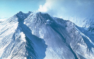
This report covers the period January-April 2000. As of 28 April 2000, KVERT (Kamchatkan Volcanic Eruption Response Team) temporarily suspended operations because of a lack of funding. Except for brief episodes of volcanic and seismic activity in mid-February and mid-March, little to no seismicity was registered beneath the volcano through the remainder of the period. Occasional, weak fumarolic activity was frequently accompanied by fumarolic plumes rising 50-800 m above the volcano and extending up to 50 km away. The volcano frequently was obscured by clouds, which prevented both visual and satellite observations.
During the week of 11-17 February seven shallow earthquakes were registered beneath the volcano. Seismic activity increased above background levels during 10-13 March, and on 14 March the hazard level color code was raised to Red due to continuous volcanic tremor after 0425, which occasionally registered at distances 100 km. At 0430, a satellite image showed a 4-pixel thermal anomaly with a temperature of 50°C and a small ash cloud. At 0742, the ash cloud rose to 5 km altitude and spread to the W; at 0815 ashfall was recorded in Kozirevsk; and at 1100 the ash cloud covered Kozirevsk and spread up to the Sredinny Range, a distance of 225 km. After 1000, the level of volcanic activity decreased and on 15 March the hazard status was reduced to Yellow after seismicity decreased to background levels. Analysis by the Alaska Volcano Observatory (AVO) of a satellite image taken at 0630 on 15 March revealed a 6-pixel thermal anomaly but no ash cloud. According to GMS-5 satellite data (Tokyo VAAC), between 0932 and 2032 on 15 March the ash cloud drifted across Shelekhov Bay and moved NW at an altitude of ~7 km.
At 0500 on the morning of 16 March the volcano erupted again, prompting a hazard status change to Orange. AVO reported that a satellite image taken at 0530 showed an 8-pixel thermal anomaly and a detached ash cloud drifting SW with the leading edge ~140 km from the volcano. The size of the cloud was estimated to be ~100 km E-W by 60 km N-S, but no height estimate was available. KVERT detected increased seismic activity under the volcano with volcanic tremor beginning around 2350 on 15 March and continuing until 0930 the next morning.
Visual reports at 2106 on 18 March from the village of Kozirevsk indicated that a dark dense plume rose to 5,000 m altitude and extended more than 150 km SW. The base of the cloud was not distinct and ashfall may have occurred. Seismicity returned to background levels after 19 March. Rock avalanches continued, although no volcanic tremor was recorded. On 19-22 March, a steam-and-gas plume rose 1-2 km above the volcano and extended up to 10 km NE and E. On 23 March, a plume rose 200 m above the volcano and satellite images analyzed by AVO continued to show a thermal anomaly, but of decreased intensity.
During the last week in March and throughout April seismicity returned to background levels and occasional fumarolic activity and shallow earthquakes were typical of the activity during the earlier part of the year.
Geological Summary. The modern Bezymianny, much smaller than its massive neighbors Kamen and Kliuchevskoi on the Kamchatka Peninsula, was formed about 4,700 years ago over a late-Pleistocene lava-dome complex and an edifice built about 11,000-7,000 years ago. Three periods of intensified activity have occurred during the past 3,000 years. The latest period, which was preceded by a 1,000-year quiescence, began with the dramatic 1955-56 eruption. This eruption, similar to that of St. Helens in 1980, produced a large open crater that was formed by collapse of the summit and an associated lateral blast. Subsequent episodic but ongoing lava-dome growth, accompanied by intermittent explosive activity and pyroclastic flows, has largely filled the 1956 crater.
Information Contacts: Olga Chubarova, Kamchatka Volcanic Eruptions Response Team (KVERT), Institute of Volcanic Geology and Geochemistry, Piip Ave. 9, Petropavlovsk-Kamchatsky, 683006, Russia; Tom Miller, Alaska Volcano Observatory (AVO), a cooperative program of a) U.S. Geological Survey, 4200 University Drive, Anchorage, AK 99508-4667, USA (URL: http://www.avo.alaska.edu/), b) Geophysical Institute, University of Alaska, PO Box 757320, Fairbanks, AK 99775-7320, USA, and c) Alaska Division of Geological & Geophysical Surveys, 794 University Ave., Suite 200, Fairbanks, AK 99709, USA.