Report on Piton de la Fournaise (France) — July 2000

Bulletin of the Global Volcanism Network, vol. 25, no. 7 (July 2000)
Managing Editor: Richard Wunderman.
Piton de la Fournaise (France) Eruptions in February, March, June, and July 2000
Please cite this report as:
Global Volcanism Program, 2000. Report on Piton de la Fournaise (France) (Wunderman, R., ed.). Bulletin of the Global Volcanism Network, 25:7. Smithsonian Institution. https://doi.org/10.5479/si.GVP.BGVN200007-233020
Piton de la Fournaise
France
21.244°S, 55.708°E; summit elev. 2632 m
All times are local (unless otherwise noted)
During 14 February to 4 March 2000 an eruption occurred at Piton de la Fournaise that was briefly mentioned in a previous report (BGVN 25:01) and is discussed here in more detail. After 4 March through May, there was no volcanic activity and seismicity was low with 1-2 events per month. On 23 June volcanism recommenced with an eruption that lasted more than a month.
Eruption of 14 February 2000. Three and a half months after its previous eruption (BGVN 24:09), Piton de la Fournaise erupted on 14 February. Throughout January, seismicity was well above normal levels until the beginning of February when a relative lull in seismicity lasted for two weeks (figure 50). At 2314 on 13 February a seismic crisis began that lasted 64 minutes. A total of 261 earthquakes occurred with magnitudes up to 1.9. The deepest events were localized at sea level, just below Dolomieu summit crater (figure 51).
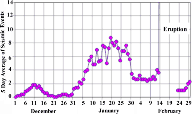 |
Figure 50. Seismic events at Piton de la Fournaise during December 1999- February 2000 shown as a series of five day averages. Heightened activity occurred through January, and a relative lull in activity occurred two weeks prior to the eruption on 14 February. Seismic information was not available for the beginning of the eruption (February 14-24). Courtesy of OVPDLF. |
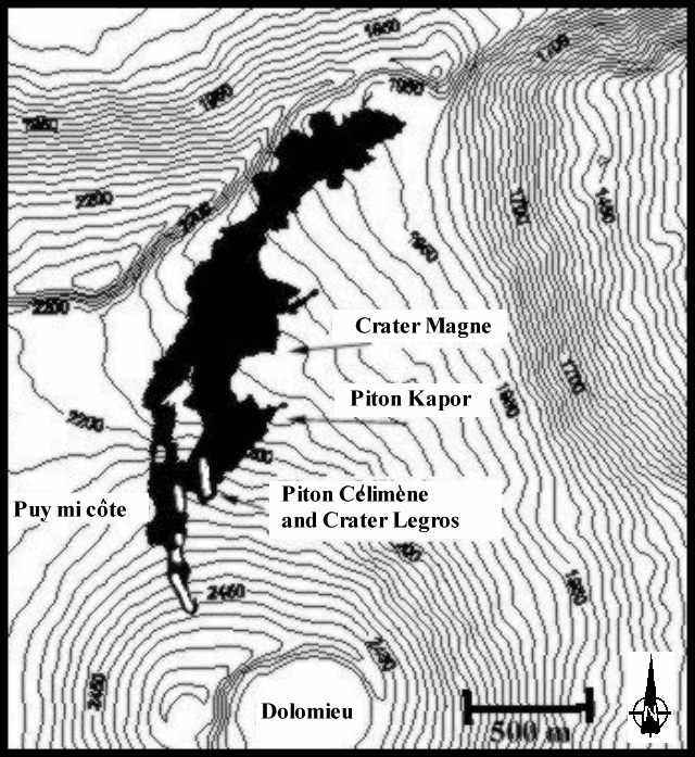 |
Figure 51. Map of the N flank of Piton de la Fournaise showing the lava flows from the 14 February 2000 eruption (black), fissure vents (white lines within the flow), and the major features associated with the flow. Note Dolomieu summit crater at lower edge of the map. Courtesy of OVPDLF. |
On 13 February, three minutes after the beginning of the seismic crisis, the first significant variations in deformation were recorded at 2317 and 2320, on radial and tangential components, respectively, by the "Dolomieu Sud" tiltmeter station. After initial deformation was observed, tiltmeter and extensometer stations at "Soufriere," "Bory," "Tunnel Catherine," and "Flanc Est" (figure 52) registered variations, with up to 270 µrad recorded for the "Soufriere tiltmeter" radial component. The intrusion of magma caused inflation under the summit crater. The inflation center started S of Dolomieu summit crater, migrated below Dolomieu, and then traveled to the N flank of the volcano where several vents opened (figure 53). At 0018 on 14 February, tremors registered at all of the seismic stations marking the beginning of the eruption.
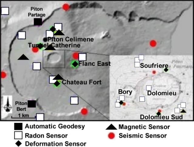 |
Figure 52. Map showing the location of radon, deformation, magnetic, and seismic stations on Piton de la Fournaise in February 2000. Courtesy of OVPDLF. |
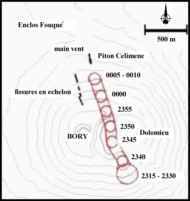 |
Figure 53. During the 14 February 2000 eruption at Piton de la Fournaise the center of inflation migrated. The incenter of inflation was calculated on 5-minute intervals and plotted on this sketch map. The center of inflation was estimted based on the shift of deformation vectors over time. Courtesy of OVPDLF. |
Inclement weather produced by cylone Eline passing 200 km N of Reunion inhibited visual observations for several days. After that, scientists found that several en echelon fissures were localized on the N flank starting at 2,490 m elevation (white lines within black lava flows, figure 53). An aa flow inundated the "Puy Mi-Côte" crater, passed to the W and E of the crater, and continued in the direction of "Piton Partage." Both vents were inactive at the time of observation. Eruptive activity was concentrated on a vent 300 m E of Puy Mi-Côte, where stable 20- to 30-m-high fountains were observed from a new crater, whose rim grew to 20 m high at that time. A second, much smaller crater was active about 100 m above the main crater. A large aa lava flow and meter-sized blocks descended in the direction of "Piton Kapor" (site of the 1998 eruption), then joined the first lava flow and followed the "rempart Fouqué" to the E. This lava flow terminated about 4 km away at 1,950 m altitude near "Nez Coupé de Saint Rose." Beginning on 24 February a large number of small pahoehoe lava flows were observed. For several hours on 4 March a large number of gas-piston events were observed and then at 1800 tremor stopped, marking the end of the eruption.
Retrospective analysis revealed that the initial aa lava flow represented most of the erupted material. The lava was particularly irregular with scoria that ranged in size from tens of centimeters to meter-sized blocks. Pahoehoe flows from the 24 February phase of the eruption partly covered the aa lava that was emitted earlier. The entire lava flow covered an area of about 1.3 x 10⁶ m2 and comprised a total volume of about 4 x 10⁶ m3 of aphyric basalt. The main new crater was called "Piton Célimène" (figure 53).
Eruption of 23 June 2000. Beginning in June, long-term deformation was observed at several stations near the volcano. Since the beginning of the month up to 0.1 mm of inflation took place at the "Soufrière" extensometer (figure 52). Starting on 12 June clear inflation of up to 70 µrad was observed at the "Dolomieu Sud" tiltmeter. After 20 June inflation of up to 20 µrad was observed at the "Château Fort" tiltmeter. The Château Fort extensometer showed variations in opening, shear, and vertical movement components.
Seismicity increased during 9-14 June with twelve deep earthquakes ~6 km below the W flank. During 15-21 June seismicity drastically increased with 2, 2, 4, 10, 29, 69, and 101 earthquakes recorded on successive days (figure 54). All of these earthquakes occurred below Dolomieu summit crater, with focal depths between sea level and 1 km above sea level. They had magnitudes up to 1.8 that increased with the number of earthquakes recorded. During the same time period, five deep earthquakes also occurred.
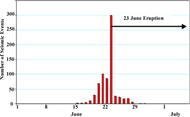 |
Figure 54. The number of daily seismic events recorded at two seismic stations at Piton de la Fournaise during 1 June through 6 July 2000. Courtesy of OVPDLF. |
During 0600-0640 on 22 June, following 50 seismic events, there was a small seismic crisis that consisted of 36 low-energy seismic events. For 36 hours after the seismic crisis only very low-energy earthquakes occurred. At 1650 on 23 June another seismic crisis took place (figure 54). It consisted of about 300 earthquakes, including some greater than M 2 and possibly as high as M 2.5. Some of the earthquakes were recorded at the seismic station in Cilaos, more than 30 km from the volcano.
During the seismic crisis one shallow earthquake was centered under the E flank of the volcano. Around this time the observatory's tiltmeter network showed uplift of the central part of the volcano to over 200 µrad. The inferred effect of an intrusion was first localized under the summit region, then shifted to the SE. At 1800 eruption tremor began, and tremor localization suggested the eruption site was on the SE flank between "Signal de l' Enclose" and "Château Fort" craters between 1.9 and 2.2 km elevation. Figure 55 shows these named locations and the actual fissure vent and extent of lava flows.
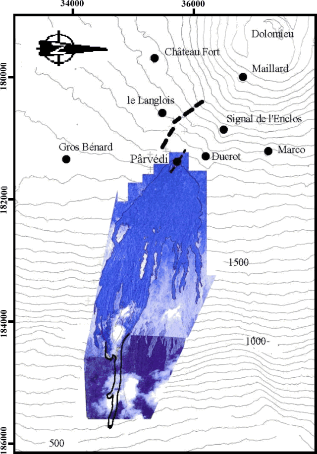 |
Figure 55. Map and image composite of the 23 June 2000 lava flows on the E flank of Piton de la Fournaise. Courtesy of OVPDLF. |
According to the observatory staff, the 23 June eruption began with the formation of a short-lived, 500-m-long, SE-trending fissure on the SE flank at an elevation of ~2,100 m (figure 55). A second, 200-m-long, ESE trending vent also formed on the SE flank at ~1,800 m. About eight lava fountains initially rose up to 50 m above the second vent. In addition, a 300-m-long aa lava flow traveled down the "Grandes Pentes" to an elevation of 580 m. About two days after the eruption began, the intensity of the lava fountains decreased, and the crater rim reached a height of 10-15 m.
Within 24 hours after the onset of the eruption, tremor rapidly decreased to less than 10% of the initial value. Unlike typical eruptions at Piton de la Fournaise, seismicity under the central crater continued for the first five days of the eruption. During 24-28 June there were 26, 22, 17, 17 and six seismic events, respectively, up to M 2.5. Similar seismic events occurred during eruptions in 1986, 1988, and 1998; in two cases they preceded the formation of new vents. However, no new vents formed during 24-28 June. After 29 June no seismic events were recorded, and starting on 27 June there was an increase in tremors that remained around initial levels and lasted three weeks. Throughout most of the eruption there was a lava lake in the eruption crater and several meter-sized lava flows emerged at its base reaching up to 300-400 m below the crater. Lava samples were collected during the eruption, and a lava temperature of 1,160°C was measured several times using a thermocouple.
On 30 July the eruption stopped after 37 days of activity. The initial flow was entirely aa lava, while the later outspreading lava flows were aa and pahoehoe lava. The entire lava flow covered an area of ~3 x 10² m2 and comprised a total volume of ~1 x 10⁷ m3. The final crater was 26 m high and was named "Piton Pârvédi."
Geological Summary. Piton de la Fournaise is a massive basaltic shield volcano on the French island of Réunion in the western Indian Ocean. Much of its more than 530,000-year history overlapped with eruptions of the deeply dissected Piton des Neiges shield volcano to the NW. Three scarps formed at about 250,000, 65,000, and less than 5,000 years ago by progressive eastward slumping, leaving caldera-sized embayments open to the E and SE. Numerous pyroclastic cones are present on the floor of the scarps and their outer flanks. Most recorded eruptions have originated from the summit and flanks of Dolomieu, a 400-m-high lava shield that has grown within the youngest scarp, which is about 9 km wide and about 13 km from the western wall to the ocean on the E side. More than 150 eruptions, most of which have produced fluid basaltic lava flows, have occurred since the 17th century. Only six eruptions, in 1708, 1774, 1776, 1800, 1977, and 1986, have originated from fissures outside the scarps.
Information Contacts: Thomas Staudacher, Nicolas Villeneuve, Jean Louis Cheminée, Kei Aki, Jean Battaglia, Philippe Catherine, Valérie Ferrazzini, and Philippe Kowalski, Observatoire Volcanologique du Piton de la Fournaise, Institut de Physique du Globe de Paris, Institut National des Sciences de l'Univers, 14 RN3 - Km 27, 97418 La Plaine des Cafres, Réunion, France (URL: http://www.ipgp.fr/fr/ovpf/observatoire-volcanologique-piton-de-fournaise).