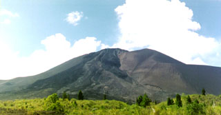
Report on Soputan (Indonesia) — October 2000
Bulletin of the Global Volcanism Network, vol. 25, no. 10 (October 2000)
Managing Editor: Richard Wunderman.
Soputan (Indonesia) Lava dome growth continues; Strombolian and ash eruptions from summit crater
Please cite this report as:
Global Volcanism Program, 2000. Report on Soputan (Indonesia) (Wunderman, R., ed.). Bulletin of the Global Volcanism Network, 25:10. Smithsonian Institution. https://doi.org/10.5479/si.GVP.BGVN200010-266030
Soputan
Indonesia
1.112°N, 124.737°E; summit elev. 1785 m
All times are local (unless otherwise noted)
This report covers the period of 1 July-31 October 2000. Activity increased and lava dome growth continued after the 13 May explosion (BGVN 25:06). By the end of June, an average of 100 earthquakes occurred per day, but the number of avalanche earthquakes decreased and fluctuated between 20 and 60 per day.
Soputan Post Observatory (SPO) at Maliku and Lokon Post Observatory (LPO) at Tomohon noted anomalous activity on 1 July. At 1200 strong tremor signals sent seismographs off-scale, but had estimated amplitudes of 20-50 mm. Visual observations at that time were hindered by haze. Workers at LPO heard a thundering sound twice at 2232, and during 2255-2303 more thundering occurred, this time accompanied by lava ejection. Lava flowed 200 m down the W flank of the volcano, and covered flows from the 13-14 May eruption.
A Strombolian eruption was observed at 0200 on 2 July with the lava fountain reaching 10-50 m above the summit. A thick white-gray ash emission reached 100 m above the summit crater and later changed to a brown color on the morning of 2 July. Further tremor earthquakes occurred with amplitudes of 30-50 mm. A dark-brown ash explosion, accompanied by a thundering sound, rose 200 m. The hazard status was set to 3 (on a scale of 1-4) on 3 July.
Reports resumed on 25-26 July, when a dense brown ash cloud rising ~1,500-3,500 m above the summit was observed along with lava fountaining to a height of 50 m. Observatory workers frequently heard rumblings from the volcano. At the end of July lava flows and lava avalanches moved down the sides of Soputan toward the SW to a distance of 400 m. Avalanche earthquakes and volcanic tremor dominated the seismic record, and an increase in deep volcanic (A-type) earthquakes took place.
Explosions issuing from the summit crater continued to be observed through the beginning of August. Ash emissions were brown-black in color, rose ~2,500 m, and were accompanied by rumbling. Lava avalanches reached distances of up to 2,000 m from the volcano, and pyroclastic flows traveled 700 m, both trending W. Seismicity remained similar to the previous week and maintained a high level. Soputan's hazard status was raised to 4 on 7 August.
Similar activity continued, and on 15 August at 2105 a dark-gray ash explosion occurred from the summit crater and rose 2,500 m. Ash from the explosion drifted SW. A Strombolian explosion followed and reached 150 m above the crater rim. The outburst was accompanied by a lava avalanche that flowed 200 m down the volcano's SW flank. Thundering that rattled windows in Maliku village 7 km away occurred coeval with the explosions. Volcanic ash advisories stated that the ash cloud from this event was carried to an altitude of 4,300 m.
Visual activity diminished until late September, but seismicity continued at similar levels until dropping in mid-September. A white, variable-density ash plume rose 25-200 m above the summit. Continuous volcanic tremor persisted until early September, and avalanche earthquakes also decreased significantly. During this period a white, variable-density ash cloud rose 50-200 m above Soputan's summit. Similar ash emissions continued until late September although cloud thickness decreased. Seismicity continued to decrease with avalanche earthquakes occurring nearly half as frequently and other earthquake types remaining similar in number.
In early October the hazard level for Soputan was decreased from 4 to 2. An ash plume continued to rise up to 200 m; in mid-October it decreased in height to 20 m above the summit crater. No further volcanic earthquakes occurred, and seismographs registered only avalanche and tectonic earthquakes for the rest of the month.
Geological Summary. The Soputan stratovolcano on the southern rim of the Quaternary Tondano caldera on the northern arm of Sulawesi Island is one of Sulawesi's most active volcanoes. The youthful, largely unvegetated volcano is the only active cone in the Sempu-Soputan volcanic complex, which includes the Soputan caldera, Rindengan, and Manimporok (3.5 km ESE). Kawah Masem maar was formed in the W part of the caldera and contains a crater lake; sulfur has been extracted from fumarolic areas in the maar since 1938. Recent eruptions have originated at both the summit crater and Aeseput, a prominent NE-flank vent that formed in 1906 and was the source of intermittent major lava flows until 1924.
Information Contacts: Dali Ahmad, Volcanological Survey of Indonesia (VSI), Jalan Diponegoro No. 57, Bandung 40122, Indonesia (URL: http://www.vsi.esdm.go.id/); Darwin Volcanic Ash Advisory Centre (VAAC), Bureau of Meteorology, Northern Territory Regional Office, PO Box 40050, Casuarina, NT 0811, Australia (URL: http://www.bom.gov.au/info/vaac/).

