Report on Colima (Mexico) — April 2001

Bulletin of the Global Volcanism Network, vol. 26, no. 4 (April 2001)
Managing Editor: Richard Wunderman.
Colima (Mexico) Correction to last report; a strong dome explosion on 22 February 2001
Please cite this report as:
Global Volcanism Program, 2001. Report on Colima (Mexico) (Wunderman, R., ed.). Bulletin of the Global Volcanism Network, 26:4. Smithsonian Institution. https://doi.org/10.5479/si.GVP.BGVN200104-341040
Colima
Mexico
19.514°N, 103.62°W; summit elev. 3850 m
All times are local (unless otherwise noted)
This report primarily covers an explosion that occurred on 22 February 2001. Colima was previously discussed in BGVN 25:06 in a summary of reports by the University of Colima's Volcano Observatory covering the interval from August 1999-May 2000. That report contained several mistakes worth noting here. First, at that time residents were not evacuated but rather were advised to avoid entering closer than a radius of 6.5 km. Second, the 11.5 km radius serves to alert residents of settlements like Yerbabuena (at 8 km radial distance) and La Becerrara (12 km) in cases of heightened activity when evacuations are called for. Such evacuations did not occur in the stated interval. Those corrections addressed, its also worth noting that citizens continued to be cautioned to avoid drainages for fear of lahars. Occasional volcanic outbursts continued, as noted in an early August 2000 observatory report. Authorities remained concerned about the possibility of strong outbursts like those seen on 10 February and 17 July 1999 (BGVN 24:01, 24:02, 24:06, and 24:08). An observatory report on 22 September 2000 noted a slight decline in activity seen in monitored parameters during the previous week. A volcanic ash advisory on 11 November 2000 reported ash to ~6 km altitude, although this could not be confirmed by GOES-8 satellite imagery.
22 February 2001: Visual and video observations. On 22 February at 0532 a strong explosion took place at Colima's intracrater dome. Based on images from video cameras at both the infrared and visible wavelengths, the explosive column expanded laterally at ~100 m/s and rose with mean velocity of ~200 m/s to attain an altitude ~3 km above the summit. The ash cloud, which on the videos appeared as a broad and conspicuous zone above the summit, proceeded to travel to the ENE and produced ashfall at a distance of ~25 km from the volcano in Tuxpan, Jalisco. Small pyroclastic flows formed in the SW sector and descended to the 3,000 m contour interval.
Inside of Colima's 250-m-diameter summit crater the explosion left a new crater ~150 m in diameter and ~30 m deep. The largest ejected blocks measured greater than 5 m in diameter and fell ~300-400 m below the crater. Principally in the volcano's NE sector, observers found rock fragments up to 1.5 km from the vent that created impact craters up to 2 m in diameter. The rock fragments consisted of fresh andesite, dome material presumably emplaced during the 1998-1999 eruption.
Seismic and tilt observations. Figure 38 shows the epicenters and hypocenters of 33 earthquakes located during February 2001. The figure shows events at depths ranging from the summit crater to 5 km below sea level. Fifteen earthquakes (M 1.9-3.9) were recorded during the 9-hour interval prior to the 22 February explosion. These events are shown on figure 38 as points surrounded by open circles.
 |
Figure 38. A map and E-W cross section for Colima plotting seismic data acquired during February 2001 (i.e., epicenters (above) and hypocenters (below)). On the map, VC is Volcán de Colima; NC is Nevado de Colima; the volcano complex's relief is shown by contours at 3,000 m, 3,500 m, and 4,000 m. The two seismic stations nearest Colima's summit are shown as triangles (designated EZV4 and EZV3); the inclinometer station (Aguila, AGL), as a cross; and the video station (Nevado, NVD), a diamond. Courtesy of V. Zobin. |
Figure 39 shows the variations in seismic energy release during February as recorded by station EZV4. The increase in seismicity starting 48 hours before the 22 February explosion is clearly seen. The seismic signal labeled "explosion" on 22 February was much larger than any others seen in the same month.
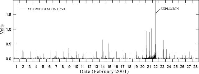 |
Figure 39. Seismicity recorded by Colima seismic station EZV4 (~ 2 km NW of the summit) during February 2001; the data illustrate the comparatively large signal obtained from the 22 February explosion. The data were recorded every 2 minutes. Courtesy of G. Reyes. |
The 22 February explosion accompanied sharp deflation. Tilt at inclinometer station Aguila (AGL, figure 38) was measured in both tangential and radial components. At this station, inclinometers underwent large sudden and non-reversing offsets due to the 22 February explosion. Specifically in the radial direction the offset was ~10 µrad and in the tangential direction, ~32 µrad. For comparison, at other times during February, diurnal variation at this station was on the order of 2 to 3 µrad. Ignoring the large 22 February displacement, the overall offsets seen for the bulk of February amounted to less than ~8 µrad. These comparisons underscore the size of station AGL's non-reversing offsets on 22 Februrary.
Geological Summary. The Colima complex is the most prominent volcanic center of the western Mexican Volcanic Belt. It consists of two southward-younging volcanoes, Nevado de Colima (the high point of the complex) on the north and the historically active Volcán de Colima at the south. A group of late-Pleistocene cinder cones is located on the floor of the Colima graben west and east of the complex. Volcán de Colima (also known as Volcán Fuego) is a youthful stratovolcano constructed within a 5-km-wide scarp, breached to the south, that has been the source of large debris avalanches. Major slope failures have occurred repeatedly from both the Nevado and Colima cones, producing thick debris-avalanche deposits on three sides of the complex. Frequent recorded eruptions date back to the 16th century. Occasional major explosive eruptions have destroyed the summit (most recently in 1913) and left a deep, steep-sided crater that was slowly refilled and then overtopped by lava dome growth.
Information Contacts: Observatorio Vulcanológico de la Universidad de Colima, Colima, Col., 28045, México (URL: https://portal.ucol.mx/cueiv/).