Report on Santa Maria (Guatemala) — April 2001

Bulletin of the Global Volcanism Network, vol. 26, no. 4 (April 2001)
Managing Editor: Richard Wunderman.
Santa Maria (Guatemala) Block lava flow continues, filling in valleys and destroying vegetation
Please cite this report as:
Global Volcanism Program, 2001. Report on Santa Maria (Guatemala) (Wunderman, R., ed.). Bulletin of the Global Volcanism Network, 26:4. Smithsonian Institution. https://doi.org/10.5479/si.GVP.BGVN200104-342030
Santa Maria
Guatemala
14.757°N, 91.552°W; summit elev. 3745 m
All times are local (unless otherwise noted)
The block lava flow that began to extend S from the Caliente vent during July 1999 (BGVN 24:12 and 25:06) remained active during January 2001. The toe of this active flow reached 3.6 km from the vent, extending down the narrow ravine of the Río Nimá II (figure 30). Across the medial section, the flow had enlarged considerably. At the location of the January 2000 flow front, flow thickness increased from 18 m to 43-67 m according to laser range finder measurements. At this point the flow was also at its widest, with a maximum width of ~510 m, and displayed prominent levees. Where the flow moved alongside the 1902 crater rim, inflation caused the flow top to rise 5-10 m above the rim. Collapses from the flow margins have fallen over this divide and extended into and down the adjacent valley. At the mouth of this valley, pyroclastic-flow deposits mantle vegetation within ~75 m of the valley floor, where upstream facing bamboo stems are charred and smaller bushes have been flattened and imbricated in the direction of flow. At this location a ~30 m deep, marginal ravine has been entirely filled with debris over a 12-month period.
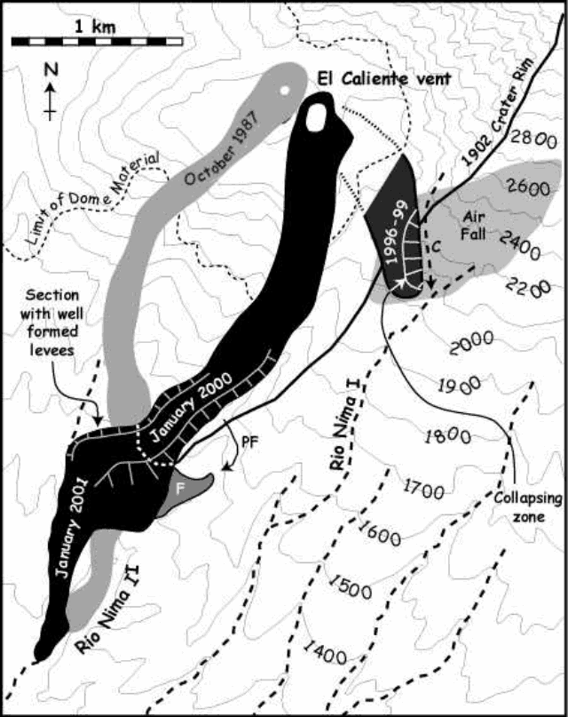 |
Figure 30. Map of Santiaguito dome developed by processing a 25 January 2001 Landsat 7 Enhanced Thematic Mapper Plus image. (C) denotes the new course of streams diverted through the 1902 crater wall by the 1996-99 flow. (PF) marks the course of pyroclastic flows from the block flow medial section, and (F) denotes valley fill observed during ground-based observations of this medial section. Courtesy of the authors (listed below). |
As during January 2000 (BGVN 25:06), the Caliente vent was filled to the brim and the area marked by a low dome feature. Between 0443 and 1105 on 25 January 2001, observers counted 25 small ash eruptions, giving a rate of ~4 per hour. Eighteen of these events were paired, comprised of two emissions separated by 1-3 minutes. More powerful events generated small (less than 400-m-long) pyroclastic flows. During the observation period, both the dome and upper flow zone suffered frequent collapses, with 156 rock falls observed. Of the 23 rock falls observed before sunrise, seven were incandescent.
The now inactive 1996-99 flow (figure 30) is being undercut by the Río Nimá I causing considerable collapse activity. A major collapse at ~0822 on 25 January fed repeated ash clouds that rose ~1 km. Repeated events of this type have removed ~33% of the distal section of this flow in 12 months. Most of this volume has collapsed into the Río Nimá I to feed continued aggradation along this river. Ashfalls from these events mantled vegetation to the E, where the zone of impacted vegetation is readily apparent in figure 30.
The rates of SO2 emission at Santiaguito were measured from a tripod site N of the Finca El Faro on four dates (25 January: 229 metric tons/day; 26 January: 90 metric tons/day; 23 February: 155 metric tons/day and 28 February: 193 metric tons/day). These emission rates represent about twice the average SO2 emission rate over the 20 year period of 1973-93 as determined by Andres and others (1993). The data suggest that SO2 emission rates increase only moderately during periods of elevated dome extrusion rate at Santiaguito.
Reference. Andres, R.J., Rose, W.I., Stoiber, R.E., Williams, S.N., Matías, O., Morales, R., 1993, A summary of sulfur dioxide emission rate measurements from Guatemalan volcanoes: Bull. Volc. 55, p. 379-388.
Geological Summary. Symmetrical, forest-covered Santa María volcano is part of a chain of large stratovolcanoes that rise above the Pacific coastal plain of Guatemala. The sharp-topped, conical profile is cut on the SW flank by a 1.5-km-wide crater. The oval-shaped crater extends from just below the summit to the lower flank, and was formed during a catastrophic eruption in 1902. The renowned Plinian eruption of 1902 that devastated much of SW Guatemala followed a long repose period after construction of the large basaltic andesite stratovolcano. The massive dacitic Santiaguito lava-dome complex has been growing at the base of the 1902 crater since 1922. Compound dome growth at Santiaguito has occurred episodically from four vents, with activity progressing E towards the most recent, Caliente. Dome growth has been accompanied by almost continuous minor explosions, with periodic lava extrusion, larger explosions, pyroclastic flows, and lahars.
Information Contacts: Andy Harris and Luke Flynn, HIGP/SOEST, University of Hawai'i, 2525 Correa Road, Honolulu, HI 96822, USA (URL: http://modis.higp.hawaii.edu/); James Vallance, Department of Civil Engineering and Applied Mechanics, McGill University, Montreal, Quebec H3A 2K6, Canada; Mark Davies, School of Environmental Sciences, University of East Anglia, Norwich, NR4 7TJ, United Kingdom; Bill Rose, Gregg Bluth, and Jeremy Shannon, Department of Geological Engineering and Sciences, Michigan Technological University, Houghton, MI 49931, USA; Otoniel Matías and Gustavo Chigna, INSIVUMEH, 7a Av. 14-57, Zona 13, Guatemala City, Guatemala.