Report on Three Sisters (United States) — May 2001
Bulletin of the Global Volcanism Network, vol. 26, no. 5 (May 2001)
Managing Editor: Richard Wunderman.
Three Sisters (United States) Radar interferometry suggests uplift during 1996-2000
Please cite this report as:
Global Volcanism Program, 2001. Report on Three Sisters (United States) (Wunderman, R., ed.). Bulletin of the Global Volcanism Network, 26:5. Smithsonian Institution. https://doi.org/10.5479/si.GVP.BGVN200105-322070
Three Sisters
United States
44.133°N, 121.767°W; summit elev. 3159 m
All times are local (unless otherwise noted)
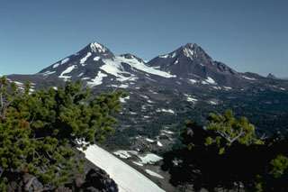
United States Geological Survey (USGS) scientists detected a slight uplift of the ground surface over a broad region centered 5 km W of South Sister volcano in the Three Sisters region (figure 1). The area is located within the central Oregon Cascade range, 35 km W of Bend, and 100 km E of Eugene, Oregon. The measured uplift, which occurred during 1996-2000, covered an area ~15-20 km in diameter; the maximum amount of uplift at the region's center was ~10 cm. Several close aerial inspections of the area revealed no unusual surface features.
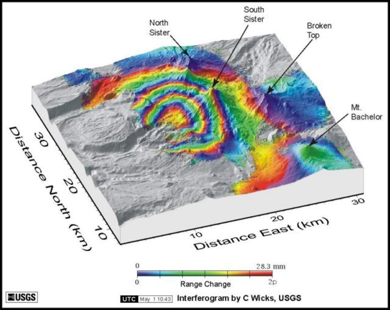 |
Figure 1. Radar interferogram showing ground uplift pattern centered ~ 5 km W of South Sister. Each shaded region represents ~ 2.8 cm of ground movement in the direction of the satellite. In this case, four concentric shaded bands show that the surface moved toward the satellite (close to vertical) by as much as 10 cm between August 1996 and October 2000. Data gaps occur where forest vegetation or other factors hinder the acquisition of useful radar data. A numerical model places the source of the uplift ~ 7 km beneath the ground surface. After a color version by Wicks and others (2001), which uses radar images from the European Space Agency's ERS satellites. |
The uplift was detected by using satellite radar interferometry (InSAR), which uses satellite data to make radar images of the ground surface (figure 1). InSAR can detect even minor (down to a few centimeters) changes in ground elevation over time. Images from 1996 and 2000 were compared and revealed the rise in ground level. The exact timing of uplift between the two dates, or whether it will continue, is unknown, but is being studied further.
The specific cause of the uplift was also uncertain. Uplift in the Three Sisters region may reflect intrusion of a relatively small volume of magma at a possible depth of 7 km. If this is the result of intrusion, it indicates that the region remains active, but does not suggest eruptive activity without additional precursors. In the Three Sisters area, earthquake activity appeared to be at or near background levels and gas emissions were low as of May 2001. The USGS plans to enhance the existing monitoring network in the region to more accurately detect possible precursors and to better understand the uplift phenomenon. Installation of one or more additional seismometers, a global positioning system (GPS) receiver, a resurvey of existing benchmarks and installation of new ones, and periodic airborne and ground-based sampling of gases are all being considered.
References. Wicks, C., Jr., Dzurisin, D., Ingebritsen, S.E., Thatcher, W., and Lu, Z., 2001, Ground uplift near the Three Sisters volcanic center, central Oregon Cascade Range, detected by satellite radar interferometry: in prep.
Geological Summary. The north-south-trending Three Sisters volcano group dominates the landscape of the Central Oregon Cascades. All Three Sisters stratovolcanoes ceased activity during the late Pleistocene, but basaltic-to-rhyolitic flank vents erupted during the Holocene, producing both blocky lava flows north of North Sister and rhyolitic lava domes and flows south of South Sister volcano. Glaciers have deeply eroded the Pleistocene andesitic-dacitic North Sister stratovolcano, exposing the volcano's central plug. Construction of the main edifice ceased at about 55,000 yrs ago, but north-flank vents produced blocky lava flows in the McKenzie Pass area as recently as about 1600 years ago. Middle Sister volcano is located only 2 km to the SW and was active largely contemporaneously with South Sister until about 14,000 years ago. South Sister is the highest of the Three Sisters. It was constructed beginning about 50,000 years ago and was capped by a symmetrical summit cinder cone formed about 22,000 years ago. The late Pleistocene or early Holocene Cayuse Crater on the SW flank of Broken Top volcano and other flank vents such as Le Conte Crater on the SW flank of South Sister mark mafic vents that have erupted at considerable distances from South Sister itself, and a chain of dike-fed rhyolitic lava domes and flows at Rock Mesa and Devils Chain south of South Sister erupted about 2000 years ago.
Information Contacts: Cascades Volcano Observatory (CVO), U.S. Geological Survey (USGS), 5400 MacArthur Blvd., Vancouver, WA 98661 USA (URL: https://volcanoes.usgs.gov/observatories/cvo/); Volcano Hazards Team, USGS, 345 Middlefield Road, Menlo Park, CA 94025-3591 USA (URL: http://volcanoes.usgs.gov/); Pacific Northwest Seismograph Network, University of Washington Geophysics Program, Box 351650, Seattle, WA 98195-1650 USA (URL: http://www.geophys.washington.edu/SEIS/PNSN/); Oregon Department of Geology and Mineral Industries, 800 NE Oregon St., Suite 965, Portland, OR 97232 USA (URL: http://www.oregongeology.org/sub/default.htm).